Gates Charles. Ancient Cities: The Archaeology of Urban Life in the Ancient Near East and Egypt, Greece and Rome
Подождите немного. Документ загружается.


392 ANCIENT ITALY AND THE ROMAN EMPIRE
and the end of this book, but continue on through the Middle Ages and the modern era. They
were variously ruined quickly or slowly; built over or left exposed; pillaged for building materials;
reconverted and reused; or surviving virtually intact – then slowly brought back to the conscious-
ness of the public from the Renaissance on, through the interests and efforts of artists, architects,
historians, and archaeologists (amateur and professional), popes and politicians, and indeed the
public at large.

CHAPTER 24
Roman provincial cities
“Hunting, bathing, having fun, laughing – That is living!” (Finley 1977: 73). This phrase (in Latin)
was discovered scratched onto the paving of the forum of Thamugadi, a Roman city in Algeria,
and for many Romans of the prosperous and peaceful fi rst through early third centuries it must
indeed have expressed their view of the ideal life. We have already examined Roman cities in the
Italian peninsula, the heartland of the Roman Empire: Cosa, Ostia, Pompeii, and Rome itself.
Let us now travel outside Italy to see how provincial cities resemble or differ from those in the
heartland. The candidates for a visit are many. How to choose? Since we have been tracking the
development of urbanism in the eastern Mediterranean and Near East, we shall concentrate on
these regions, exploring to what degree Roman cities continued earlier traditions. Moreover,
the evidence from the eastern half of the empire is particularly rich. Shifts in habitation in this
region led to the abandonment of many major Roman cities – and hence to their preservation.
The western empire deserves our attention, too. For the most part, the pre-Roman past of this
region has lain outside the scope of this book. Apart from Phoenician and Greek settlements in
coastal Spain and Mediterranean France, an urban tradition did not develop there until brought
by the Romans. The local contexts are thus quite different from those in the eastern empire. As
a result, the study of western Roman cities strikes a different tone.
We shall examine ten cities: seven examples from the eastern Mediterranean, and three from
western Europe. Our exploration will begin with Athens, and then move in a clockwise direction
to Ephesus and Pergamon, Perge, Palmyra, Jerash, and Lepcis Magna. We shall then cross the
Mediterranean to France, England, and Germany, to finish with a look at Nîmes, London, and
Trier (see the map, Figure 23.1). These cities raise questions about Roman cities that we should
keep in mind as we explore our examples. Seven themes seem of particular interest. First, the
blend of Roman culture with pre-existing cultures, and how this mix was expressed in the urban
landscape will be key in the eastern region with its several thousand years of urban experience.
Athens was a cultural heirloom for the Romans, a seat of revered Greek culture, but nonetheless
the Romans introduced their favorite building types. Second, religious syncretisms, or the mul-
tiplicity of cults, result in variations of temple and tomb structures. In Ephesus and Pergamon,
Egyptian cults mingled with Greek and Roman religions, whereas in Syrian Palmyra, the Classical
mixes with the native Near Eastern. Third, the varying economic bases of towns, dependent on
the geographic location of cities, may affect the appearance of cities, and the experiences of their
inhabitants. Fourth, city layouts may vary, with newly founded cities having different types of
plans from older, established cities. In addition, local topographies can affect city plans. Fifth,
building types and plans, the elements of the physical world of the city: to what degree are they
uniform throughout this region, to what degree do they differ? Sixth, the traditions of construc-
tion: to what degree were these techniques local, to what degree brought from Italy? Seventh and
last, we are also interested in benefactors, imperial and local: who were they, and what did they
394 ANCIENT ITALY AND THE ROMAN EMPIRE
hope to gain from their gifts to their city? In sum, what constitutes a Roman city? Can we indeed
recognize a Roman city, no matter where we might be in the Empire?
ATHENS
“Greece, the captive, took her savage victor captive, and brought the arts into rustic Latium”
(Alcock 1993: 1). So wrote Horace about the lasting power of Greek culture for the Romans
despite the latter’s military conquest of the Greek world. For the Romans, no city better symbol-
ized the achievements of Greek culture than Athens. Although not the major commercial and
administrative city of the Greek peninsula under Roman rule, now organized as the province of
Achaia – that was Corinth, destroyed by the Romans in 146 BC, then resettled as a colony in 44
BC – Athens retained its special aura. The city maintained its reputation as an intellectual center
for many centuries, even after the crippling attack in 267 of the Herulians, a Germanic tribe from
eastern Europe. The end of its long tradition finally came in 529, when the Byzantine emperor
Justinian closed its famous philosophical schools.
When a Roman emperor wished to emphasize his philhellenism, he would donate a magnificent
new monument to Athens, thereby paying homage to this city and to the intellectual and artistic
life that it had nurtured for centuries. The two emperors who drew most upon Greek models for
urban architecture were Augustus and Hadrian. Indeed, they both made gifts to Athens (see the
map of Athens, Figure 14.1). Augustan monuments include the Temple of Roma, a small circular
temple placed east of the Parthenon, its Ionic order copying that of the recently refurbished Erech-
theion; and the Roman Agora, a porticoed rectangular market square built to the east of the older,
established agora. The most important building of this period was the large Odeion of Agrippa, a
covered theater built in 15 BC in the older agora, a donation of Augustus’s son-in-law.
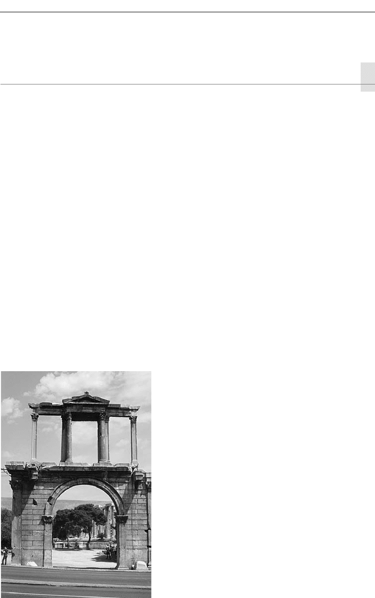
Hadrian visited Athens in 133; in honor of his trip, he built a monumental gate (Figure 24.1).
The gateway combines Roman and Greek forms: a Roman arch below, but Greek post-and-lintel
Figure 24.1 Hadrian’s Arch, Athens

ROMAN PROVINCIAL CITIES 395
forms in the upper tier. It marks the boundary between the established earlier Greek city and
the sector newly developed by the Romans, enclosed in an extension of the city wall. This func-
tion was noted by the inscriptions carved on its lower friezes: “This is Athens, the ancient city
of Theseus” (on the west) and “This is the city of Hadrian, not of Theseus” (on the east). Other
building projects of Hadrian included a library, built next to the earlier Roman Agora, and the
completion of the Olympieion, the huge temple to Zeus begun in the late sixth century BC and
much advanced, but not finished, in 175–164 BC. The Olympieion, at least, lies just to the east of
Hadrian’s arch, thus inside Hadrian’s city.
Imperial patrons were not alone in making gifts to the city. Local philanthropy existed, too.
Herodes Atticus, a wealthy Athenian of the mid-second century, donated the large odeion built
into the south-west slope of the Acropolis as a memorial to his wife, Regilla.
After the Herulian attack of 267, a new defensive wall was built, the “Valerian Wall.” The area
enclosed was much smaller than that of the Themistoklean Wall with its Hadrianic extension,
and shows clearly how dramatically the city had shrunk. However great its lingering prestige,
Athens had now become an economic backwater, a minor town important only for its region.
This situation continued through the Middle Ages and the Ottoman period. In 1834, the for-
tunes of the city once again changed sharply, with its selection as the capital of the recently
independent Kingdom of Greece.
EPHESUS AND PERGAMON
The vital centers of the Greek areas of the Roman Empire lay not on the Greek peninsula, but
further east: on the east Aegean coast in the province of Asia (Ephesus and Pergamon), in the
province of Syria (Antioch, today the Turkish city of Antakya), and Egypt (Alexandria) – all well-
established in the earlier Hellenistic period. Ancient remains of the last two cities are difficult
of access, being overlain by silting (Antioch) and later occupation (both). Ephesus, however,
and much of Pergamon have been the objects of rewarding archaeological excavations, thanks
to shifts in settlement location from ancient to medieval and modern times that have made the
ancient remains easier to reach.
Pergamon in Roman times we have already touched upon in Chapter 18. The Trajaneum, or
Temple of the Divine Trajan, of the early second century was the main building of this period
on the Acropolis. It set the orientation for the grid plan that determined orientations of new
construction even down on the plain below. We also noted the Asklepieion, the sanctuary just
out of the city, with its important construction of the second century.
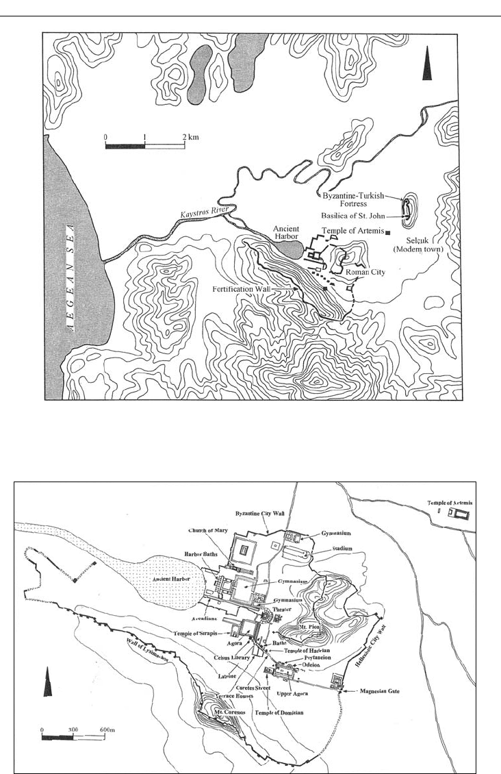
Ephesus was the capital of the Roman province of Asia, with a large population estimated
at 250,000. Occupied since the Bronze Age, it was an important Greek and then Roman city,
internationally famous for its Temple of Artemis and blessed with good harbor facilities. In
late Roman times, its commercial and political prominence came to an end, as silting from the
Cayster River filled the harbor. Today the Roman ruins lie several kilometers from the Aegean
coastline (Figure 24.2). By Justinian’s time (sixth century), the site of the Roman city was given
up in favor of a defensible inland location, around the tomb and basilica church of St. John, the
apostle and evangelist.
The Roman city has been brought to light by Austrian excavations conducted since 1897. A
walk through the extensive ruins gives a good impression of the grandeur of this major Roman
city (Figure 24.3). The topography has much affected the city’s layout, for the city lies between
two hills. A central street (Curetes Street), dominating the plan, runs downhill from the west
396 ANCIENT ITALY AND THE ROMAN EMPIRE
Figure 24.2 Regional plan, Ephesus and environs
Figure 24.3 City plan, Ephesus
ROMAN PROVINCIAL CITIES 397
through the saddle between the two hills. On the south hillside, at least, excavations have revealed
well-preserved houses of the wealthy, arranged on terraces. The main street continues down to
the Library of Celsus, then turns north toward the Greco-Roman theater (where St. Paul was
denounced as a troublemaker to the assembled multitude by a maker of statues of Artemis),
then west again going straight to the harbor. This last leg is a fourth- or fifth-century reworking,
complete with the then still unusual addition of street lights.
Excavation projects at large Greco-Roman sites in Turkey have been encouraged by the gov-
ernment to restore selected buildings. The Austrian excavators at Ephesus are now focusing on
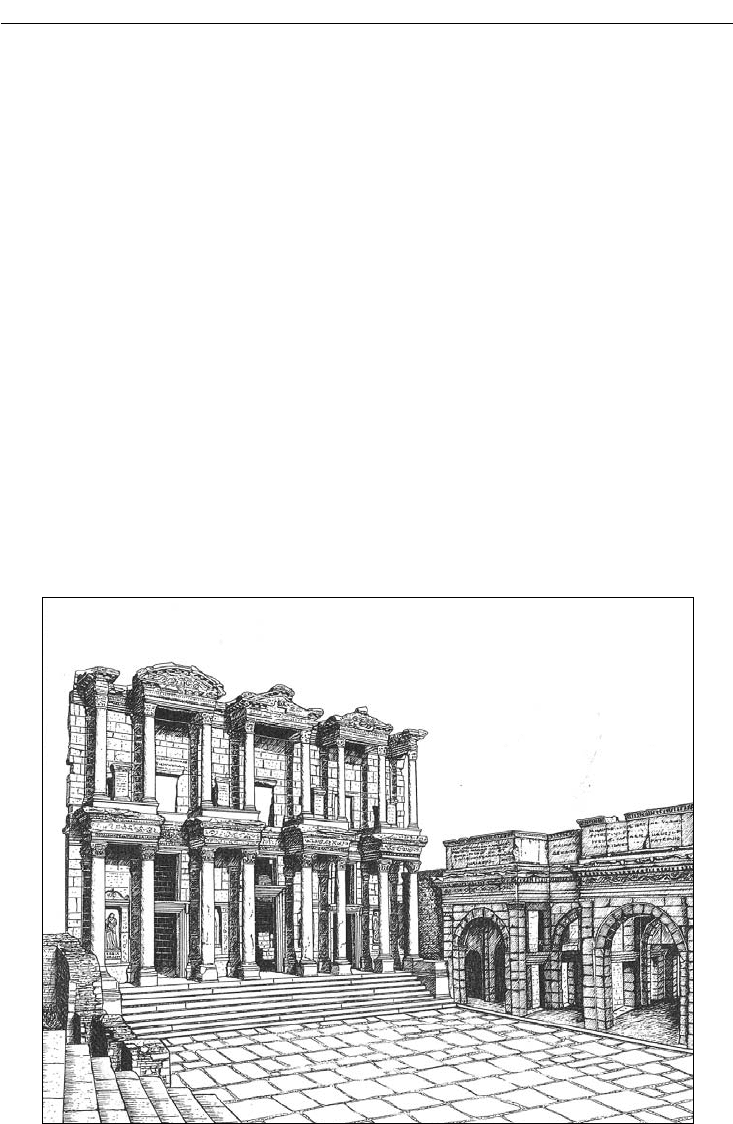
the hillside houses mentioned above. Earlier, they restored the façade of the Library of Celsus
(Figure 24.4). This library was built in 110 by Gaulius Julius Aquila in honor of his father, Gaius
Julius Celsus Polemaenus, proconsul of Asia in 106–107. Its beautiful façade is decorated with
projections and niches that recall the stage buildings of Roman theaters. Statues personifying
qualities of Celsus, such as Wisdom and Virtue, fill the niches on either side of the central door-
way. Behind the façade, the building is simpler and smaller. A single interior room originally was
equipped with three stories of galleries for the storage of manuscripts. Celsus himself was buried
in a basement chamber, in a lead coffin placed inside a marble sarcophagus, found in situ but not
opened. It was rare for an individual to be buried inside the city limits, and is a mark of Celsus’s
distinction.
In the eastern Mediterranean, local building traditions were hardly changed by the arrival of
the Romans. Cut stone was still favored, whereas the concrete and brick constructions typical
in Italy and the central and western Mediterranean were unusual. A striking contrast of the two
Figure 24.4 Library of Celsus and South Gate of the Agora, Ephesus

398 ANCIENT ITALY AND THE ROMAN EMPIRE
types of construction can be seen in two temples traditionally (although not without controversy)
attributed to Serapis: one at Ephesus, the other at Pergamon. Serapis was the Ptolemaic hybrid of
the Egyptian Apis with the Greek Hades (Chapter 18); his cult remained popular both in Egypt
and in regions with commercial contacts with Egypt during the imperial centuries. At Ephesus,
the Temple of Serapis of the early second century looks like a standard Greco-Roman temple.
Its post-and-lintel structure comes from the Greek tradition, as does its decoration, Corinthian
columns on the porch, and carved architectural decorative motifs such as bead-and-reel and egg-
and-dart. Roman in concept is its imposing frontality, with steps leading up to the entry. Indeed
the front view is all there is, for the temple is nestled against the hillside, built on a terrace cut out
of the bedrock. One cannot walk around it. The cella is a single room, modest in size; cuttings
for water channels indicate the importance of water in the cult. To the Egyptian tradition belongs
the massive scale of the temple, especially its front porch. The columns are monoliths 14m–15m
high, and the door frame is constructed of colossal blocks. The wheels that held the ends of the
gigantic door flaps rolled along large arcs cut into the floor blocks.
The Temple of Serapis, or the Temple of the Egyptian Gods, at Pergamon is quite different.
Known today as the Red Hall (Kızıl Avlu, in Turkish), this building complex lies at the base of
the acropolis hill, on flat ground. The Red Hall is made of baked bricks and concrete, an unusual
choice in Roman Asia Minor. Massive, the building rose two stories high. Marble veneer would
have covered the walls, but that has been stripped away. A Christian church was later constructed
inside (also the fate of the Serapeion at Ephesus), thereby altering and even destroying some of
the pre-Christian architectural features.
The identification of the Red Hall as a temple for Egyptian gods is not certain. However,
several striking features make this likely. The complex is extremely large. The main building
measures 60m × 26m. It is flanked by round towers with a smaller court in front of each. In front
of this three-part structure lies a huge court (ca. 200m × 100m), today mostly covered by modern
buildings. Under this court the Selinus (mod. Bergama) River still flows; it has been proposed
that this river was symbolic of the Nile. In addition, caryatid columns used in the smaller courts
that flank the main building have been carved on two sides with men and women, both in realis-
tic Greco-Roman style, but some wearing Egyptian pharaonic headgear. The Red Hall contained
a colossal statue, perhaps of Serapis. This statue was hollow, and a priest could climb into it and
speak out, as if he were the god speaking. The hole in the statue base can still be seen.
A current project of the German Archaeological Institute in Istanbul to document and analyze
afresh this building may provide new answers about its identification and function. Whatever the
results, the Red Hall remains unique in Asia Minor, a monumental complex constructed in brick,
a construction technique brought from afar. Clearly the effect sought from its scale, layout, and
materials was very special indeed.
PERGE
Royal patronage has proved an important factor in the embellishment of towns, likewise the
interest of wealthy benefactors, such as Herodes Atticus. Almost always these patrons were men.
Unusual, then, is the city of Perge in Pamphylia, on the south coast of Asia Minor, where the
most famous benefactor was a woman, Plancia Magna. Of distinguished family, Plancia Magna
was nonetheless no mere appendage to male glory; inscriptions of dedications and commemora-
tions found in the Turkish excavations at Perge have revealed that in the early second century
she was the leading force of her family.
ROMAN PROVINCIAL CITIES 399
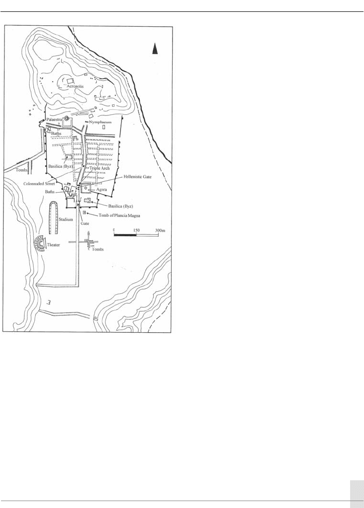
Perge lies a few kilometers inland from
the port town of Attaleia (today’s Antalya)
focusing on a low flat hill, the sort of forma-
tion much appreciated in this area. For much
of Perge’s history, the flat hill became the
defended acropolis. Here, excavations have
recovered finds dating as far back as the Early
Bronze Age; a possible Hittite city is still unat-
tested, however. Probably in the Hellenistic
period settlement expanded down the slope
of the hill, then, in late Hellenistic and Roman
times, to the south of the hill on slightly slop-
ing, almost flat ground. A wall surrounded
the town, built by the Seleucids in the third
century BC, supplemented by an enlargement
in the fourth century AD. Outside the walled
town lay a theater, built up against a nearby
hill, and a well-preserved stadium. Also out-
side was a Temple to Artemis, which accord-
ing to literary sources was the most famous
building of Perge. Despite much prospecting
in the region, it has not yet been found.
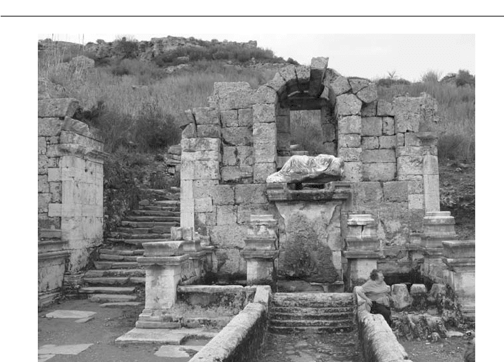
The city is divided by crossing streets into
four unequal areas (Figure 24.5), with city
blocks of different sizes. The main north–
south street, porticoed on both sides and with
a stone-lined watercourse down the middle,
runs from an elaborate nymphaeum (fountain
building) at the base of the acropolis (Figures
24.7 and 24.8) southward to the entrance gates. The Hellenistic gate is marked by a round tower
at either side (Figure 24.6). According to inscriptions, Plancia Magna renovated the gate, adding
its horseshoe-shaped court and a monumental triple archway at the north end of the court. The
interior walls of the court were lined with two levels of niches, seven above and below on each
side, each filled with a statue of a founder or prominent citizen of the city. Indeed, much sculp-
ture has been found at Perge, now on display in the Antalya Museum. Its local production was
substantial, although not rivaling that of Aphrodisias in the Maeander River valley to the north-
west, whose nearby marble quarries were exploited for an industry with a lively export trade.
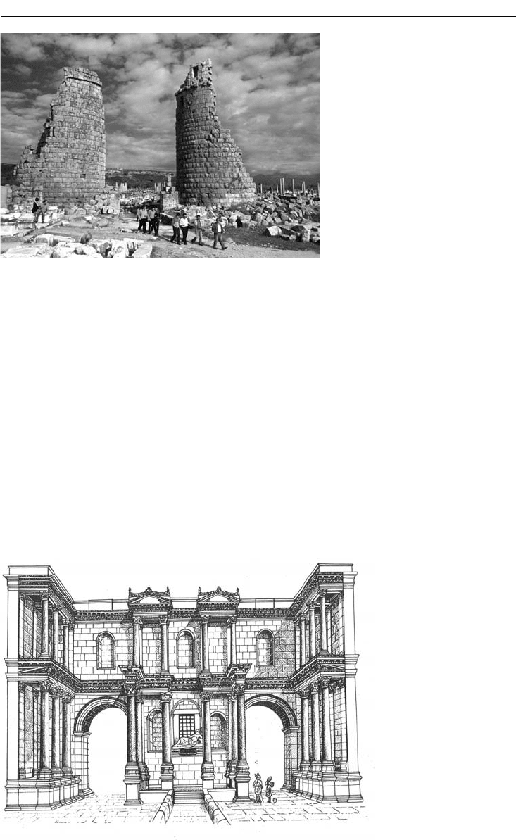
PALMYRA
Palmyra, the “place of palms,” the Roman version of Tadmor, the old Semitic name, is located
at an oasis in the Syrian desert. Although occupied since prehistoric times, its early settlements
are poorly known. The city’s great prosperity and most surviving architecture date from the late
Hellenistic period to the late third century
AD. Especially in the second and third centuries, Pal-
myra grew rich from long-distance caravan trade, from its central position on an east–west trade
route between the Mediterranean coast and the Euphrates River and Mesopotamia. Political
Figure 24.5 City plan, Perge
400 ANCIENT ITALY AND THE ROMAN EMPIRE
conditions in the Near East made this route important at this time. To the south, the Nabataeans,
who earlier dominated trade from their capital city of Petra (in modern Jordan), were annexed by
the Romans in the early second century and lost their commercial ascendancy. In addition, Pal-
myra was well placed between long-standing rivals, the Romans and, to the east, the Parthians,
the rulers of Mesopotamia and Iran. Although the city belonged to the Romans, the Palmyrenes
were Semitic. Their culture was thus a blend of local Syrian with an admixture of Mediterranean
Greco-Roman elements.
The Romans took control of Palmyra some time in the first century. Hadrian visited in 129
with great celebration. The most dramatic episode in the city’s history occurred in the later third
century. After the Sassanian Persians (the successors of the Parthians) defeated and captured the
Roman emperor Valerian at Edessa in 260, Roman rule in Syria seemed to crumble. A Palmyrene
tribal leader, Odainat (Odaenathus, in Latin), stepped into the gap to protect his city’s interests.
He declared himself king of Palmyra, although remaining nominally a vassal of Rome. Acting as
Rome’s regional ally, he consolidated his position with victories over the Sassanians. His success
was short-lived: in 267 he was assassinated. His widow, Bat Zabbai (better known as Zenobia),
Figure 24.7 North nym-
phaeum (reconstruction),
Perge
Figure 24.6 South Gate, Hellenistic
period, Perge
ROMAN PROVINCIAL CITIES 401
took charge as regent for her infant son, and quickly put into motion an ambitious program of
conquest. Her armies captured Egypt and marched into Asia Minor. Then she proclaimed her
son Augustus, that is, a ruler independent of Rome. At this the Romans finally reacted. In 272,
the emperor Aurelian attacked and captured Palmyra, but spared the city. Zenobia, by most
accounts, was taken to Rome and displayed to the crowd in Aurelian’s triumphal procession; she
spent the rest of her life in comfortable detention in Tivoli, outside Rome. Soon after Aurelian’s
victory, the Palmyrenes massacred the occupying garrison; in revenge, the Romans sacked the
city. The city never recovered from this blow.
Palmyra is an extremely evocative site. The warm colored, intricately carved classical architec-
ture of this abandoned oasis city spreads out in the desert sands at the foot of a bare mountain
(Figure 24.9). From the seventeenth century, western travelers began to visit and write about the
ruins. Systematic exploration began in the late nineteenth century with a Russian team; German,
French, Swiss, Polish, and Syrian researchers have followed.
The architecture of Palmyra is, in general, Greco-Roman, but modifications were made by this
Semitic people with their own gods and their own customs. The main colonnaded street, with its
monumental arched gateway and tetrapylon, is firmly Roman; so too is the theater. Colonnaded
streets, gateways and theaters are architectural forms fulfilling functions found throughout the
Roman world, so the Roman architectural style comes as no surprise. Different in style, in con-
trast, are temples and tombs, building types that reflect local religious practices.
The major temple at Palmyra was consecrated to the Semitic god Bel. The cult on this site
must antedate the temple of the Roman period, for the orientation of the precinct and temple
differs from that of the central colonnaded street and the rough grid plan of the city proper.
Built in the first half of the first century, dedicated in 32, the Temple of Bel shows a remarkable
synthesis of Near Eastern and Greco-Roman forms (Figures 24.10 and 24.11). From the outside,
Figure 24.8 North nymphaeum, Perge