Flechtner F.M., Gruber Th., G?ntner A., Mandea M., Rothacher M., Sch?ne T., Wickert J. (Eds.) System Earth via Geodetic-Geophysical Space Techniques
Подождите немного. Документ загружается.

Using ARGO, GRACE and Altimetry Data t o Assess the Quasi Stationary 355
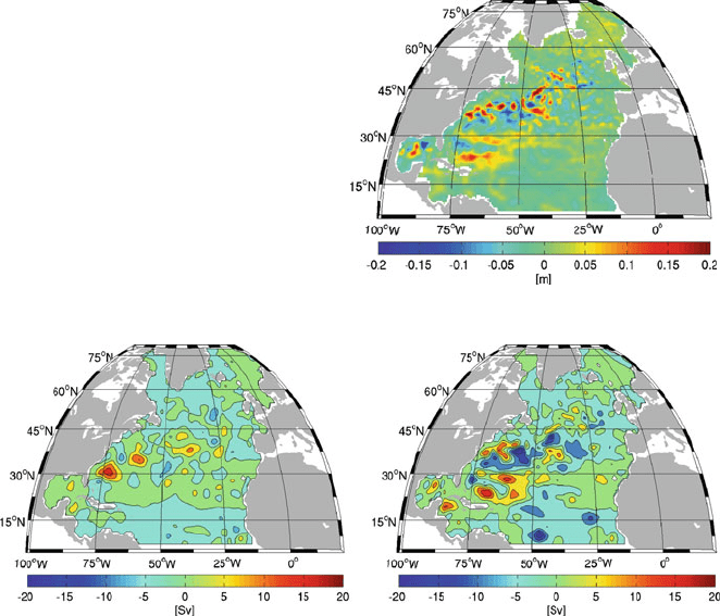
Fig. 4 Inter-annual change in
altimetry data (2006–2005)
Fig. 5 Change in barotropic stream function (ARGO06-ARGO05 left and AltARGO06-
AltARGO05 right). Altimetry has a stronger impact on total transports then ARGO data have
more pronounced changes in AltARGO experiments. The changes in T and S fields
are distinct and quite similar between ARGO only experiments and AltARGO solu-
tions. In accordance to these findings, only smaller modifications in T and S are
needed to compensate for the misfit in surface elevation. The variability in transports
can be either explained by the bottom pressure change (which is loosely constrained
during the assimilation to that of a forward solution; Sidorenko et al., 2005) or the
change in vertically integrated potential energy (which is the result of redistribution
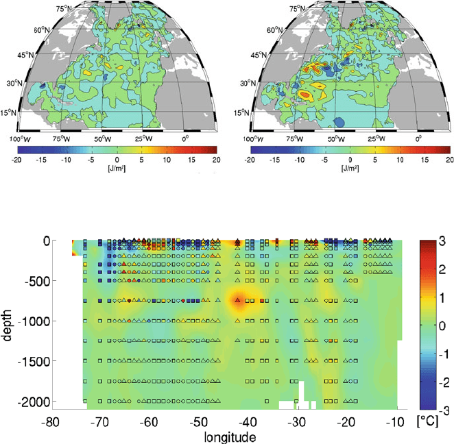
of T and S within the water column). Figure 6 shows the difference in vertically
integrated potential energy between ARGO06-ARGO05 (left panel) and between
AltARGO06-AltARGO05 (right panel).
It demonstrates that a significant part of the transport variability is due to the
variability in vertically integrated potential energy. Thus, despite the fact that T
and S adjustments done by IFEOM are mainly due to the ARGO anomalies, the
modifications in potential energy are mainly from including altimetry. The latter in
turn has a significant impact on transport variability.
Figure 7 shows the temperature change (AltARGO06-AltARGO05) across a sec-
tion at 37.5
◦
N. It is dominated by the ARGO anomalies. The changes due to the
altimetry assimilation are an order of magnitude smaller and are of the same sign
356 F. Richter et al.
Fig. 6 Change in vertical integrated potential energy (ARGO06-ARGO05 left and AltARGO06-
AltARGO05 right) scaled by 10
–5
. The transport changes induced by using altimeter data are
produced by adjusting the vertical density structure in the model
Fig. 7 Temperature change along a section through the North Atlantic at 37.5
◦
N. Difference
between solutions AltARGO06-AltARGO05 is shown in background colour. The difference in
the observations (2006–2005) at ARGO positions is depicted by colour coding the following sym-
bols: both years are present in ARGO data (circle), if only 1 year (2005 square, 2006 triangle)is
present the difference is computed using the climatology data instead of the missing year
within the entire depth (not shown here). The plot demonstrates that the model takes
into account even the transient signal which can be present in raw data. The pattern
of positive anomaly at about 40
◦
W corresponds to an unstable profile measurement
(year 2005). This anomaly is partly captured by IFEOM (which accounts for the
whole available information) and results in stable model solution.
4 Summary and Conclusions
The quasi-stationary circulation of the North Atlantic is estimated for the years
2005–2006 using ARGO, GRACE and altimetry data. The assimilation technique
has been used to reduce the misfit between data and model by adjusting T and S
Using ARGO, GRACE and Altimetry Data t o Assess the Quasi Stationary 357
fields. It is shown that inclusion of the additional information from altimetry sig-
nificantly changes the estimates of transports and variability. The sea level rise
between 2005 and 2006 of about 5 cm in the Nordic seas is shown to be present
in both, ARGO and altimetry data. Both datasets also reveal large variability in
the Gulf Stream region and its extension which contributes to the estimated inter-
annual differences of about 20 cm. The Gulf Stream region shows the transport
variability of about 20 Sv in maximum. The changes are more pronounced for the
simulations including altimetry data despite the fact that using altimetry leads to
only small additional adjustments in T and S. These adjustments in turn modify
the vertically integrated potential energy significantly, which explains the transport
variability. Thus, the vertically integrated potential energy anomaly shows that the
transport variability is dominated mainly by the altimetry information while the
major changes in T and S are explained by the ARGO data.
Acknowledgment This is publication no. GEOTECH 1249 of the GEOTECHNO-LOGIEN
programme of BMBF, grant 03F0434B.
References
Ganachaud A, Wunsch C (2003) Large-scale ocean heat and freshwater transports during the world
ocean circulation experiment. J. Clim. 16, 696–705.
Gouretski VV, Koltermann KP (2004) WOCE Global Hydrographic Climatology. Bundesamt für
Seeschifffahrt und Hydrographie, Hamburg und Rostock, Germany.
Guinehut S, Coatanoan C, Dhomps A-L, Le Traon P-Y, Larnicol G (2009) On the use of satellite
altimeter data in ARGO quality control. J. Atmos. Oceanic Technol. 26, 395–402.
Ivchenko VO, Danilov SD, Sidorenko DV, Schröter J, Wenzel M, Aleynik DL (2007)
Comparing the steric height in the Northern Atlantic with satellite altimetry. Ocean Sci. 3,
485–490.
Kivman G, Danilov S, Fritzsch B, Harig S, Reick C, Schröter J, Seufer V, Sidorenko D, Staneva
J (2005) Improved estimates of the oceanic circulation using the CHAMP geoid. Earth
Observation with CHAMP, Results from Three Years in Orbit, Springer-Verlag, Heidelberg,
pp. 211–216.
Losch M, Schröter J (2004) Estimating the circulation from hydrography and satellite altimetry in
the southern ocean: limitations imposed by the current geoid models. Deep-Sea Res. I 51(9),
1131–1143.
Lumpkin R, Speer K (2007) Global ocean meridional overturning. J. Phys. Oceanogr. 37,
2550–2562.
Reigber C, Schmidt R, Flechtner F, König R, Meyer U, Neumayer K-H, Schwintzer P, Yuan Zhu S
(2005) An earth gravity field model complete to degree and order 150 from GRACE: EIGEN-
GRACE02S. J. Geodyn. 39(1), 1–10.
Rio MH, Hernandez F (2004) A mean dynamic topography computed over the world ocean from
altimetry, in situ measurements, and a geoid model. J. Geophys. Res. 109, C12032.
Rio MH, Schaeffer P, Lemoine JM, Hernandez F (2005) Estimation of the ocean Mean Dynamic
Topography through the combination of altimetric data, in-situ measurements and GRACE
geoid: from global to regional studies. Proceedings of the GOCINA international workshop,
Luxembourg.
Sidorenko D, Danilov S, Kivman G, Schröter J (2005) On the use of a deep pressure gradient
constraint for estimating the steady state ocean circulation from hydrographic data. Geophys.
Res. Lett., doi: 10.1029/2005GL024716.
358 F. Richter et al.
Stammer D, Wunsch C, Giering C, Eckart C, Heimbach P, Marotzke J, Adcroft A, Hill CN,
Marshall J (2002) The global ocean circulation during 1992–1997, estimated from ocean
observations and a general circulation model. J. Geophys. Res. 107(C9), 3118–3145.
Stammer D, Wunsch C, Giering C, Eckart C, Heimbach P, Marotzke J, Adcroft A, Hill CN,
Marshall J (2003) Volume, heat and freshwater transports of the global ocean circulation 1993–
2000, estimated from a general circulation model constrained by World Ocean Circulation
Experiment (WOCE) data. J. Geophys. Res. C1, 3007.
Treguier AM, Theetten S, Chassignet EP, Penduff T, Smith R, Talley L, Beismann JO, Böning C
(2005) The north Atlantic subpolar gyre in four high-resolution models. J. Phys. Oceanogr. 35,
757–774.
Wenzel M, Schröter J (1998) Combined assimilation of altimetric and hydrographic data. AVISO
Newsletter 6, 122–124.
Wenzel M, Schröter J, Olbers D (2001) The global ocean circulation during 1992–1997, estimated
from ocean observations and a general circulation model. Prog. Oceanogr. 48(C9), 73–119.
Wenzel M, Schröter J (2002) Assimilation of TOPEX/Poseidon data in a global ocean model:
differences in 1995–1996. Phys. Chem. Earth 27, 1433–1437.

A 15-Year Reconstruction of Sea Level
Anomalies Using Radar Altimetry
and GPS-Corrected Tide Gauge Data
Nana Schön, Saskia Esselborn, and Tilo Schöne
1 Introduction
When estimating sea level changes over the last century, one major problem is the
spatial non-uniformity. Regional estimates give a broad range of results for sea level
rise. For the determination of consistent time series, satellite radar altimetry data
(RA) with its short but near-global coverage must be combined with the relatively
long but spatially sparse set of tide gauge time series. Church et al. (2004) devel-
oped a reconstruction scheme that takes i nto account the regional differences and
can produce reliable estimates. In this paper, a similar reconstruction procedure is
used, but improved in two aspects. First, the typical correction for land movement,
commonly accomplished by employing a global isostatic adjustment (GIA) model
(e.g., Davis and Mitrovica, 1996; Lambeck et al., 1998; Peltier, 2004), is replaced by
applying vertical land movement trends extracted from the combined TIGA (GPS
Tide Gauge Benchmark Monitoring – Pilot Project) dataset of co-located GPS sta-
tions to the tide gauge data set (Schöne et al., 2009). Second, a careful selection of
the tide gauges used in the reconstruction minimizes the influence of their spatial
distribution.
2 Methodology
For the reconstruction of sea level anomalies (SLA), a modified Optimal
Interpolation (OI) algorithm (Kaplan et al., 1997) is applied. Fully corrected and
harmonized monthly altimetric sea surface height anomaly data derived from the
Altimeter Database and Processing System ADS (chapter “Radar Altimetry Derived
Sea Level Anomalies – The Benefit of New Orbits and Harmonization” by Schöne
et al., this issue) are gridded into 1
◦
× 1
◦
maps and are used t o estimate the global
N. Schön (B)
Helmholtz Centre Potsdam, GFZ German Research Centre for Geosciences,
Department 1: Geodesy and Remote Sensing, Telegrafenberg, 14473 Potsdam, Germany
e-mail: nana.schoen@gfz-potsdam.de
359
F. Flechtner et al. (eds.), System Earth via Geodetic-Geophysical Space Techniques,
Advanced Technologies in Earth Sciences, DOI 10.1007/978-3-642-10228-8_30,
C
Springer-Verlag Berlin Heidelberg 2010

360 N. Schön et al.
covariance structure as expressed in empirical orthogonal functions (EOFs). The
amplitude of these EOFs is estimated using tide gauge records. This way, the main
spatial patterns of the SLAs are extracted from the RA data, while their amplitude
time series is reconstructed using the tide gauge data. For this reconstruction, the
first 25 area-weighted EOFs are used, which cover over 91% of the global variabil-
ity. Church et al. (2004) have argued that this number of EOFs is sufficient for an
OI reconstruction.
The land movement part of the tide gauge records is GPS-corrected using verti-
cal trends derived from the TIGA combination (chapter “Reanalysis of GPS Data at
Tide Gauges and the Combination for the IGS TIGA Pilot Project” by Rudenko et al.
this issue). For this study, 18 tide gauges (see Schöne et al., 2009) are selected
from the global TIGA network. Tide gauge data for the period 1987–2001 are taken
from the PSMSL data archive (Woodworth and Player, 2003). The selection cri-
teria are chosen such as to comply with the recommendations of Douglas (2001)
for tide gauges, as well as Blewitt and Lavallée (2002) for the GPS time series.
An additional three tide gauges (La Libertad 2 (PSMSL ID 845/012), Pt. La Rue
(PSMSL ID 442/007), Unalaska (PSMSL ID 820/021)) were used for the stabiliza-
tion of the OI algorithm (see Schöne et al., 2009 for a detailed discussion). Only a
small number of tide gauges satisfy all the necessary selection criteria. In addition
to this, the influence of their geographical distribution on the reconstruction hinders
a more flexible selection of tide gauges. Adaptively using all tide gauges available
for a certain period of time is not recommended, since the i ntegrity of a changing
geographical distribution in time cannot be determined. Instead, a fixed configura-
tion of tide gauges that must stay unchanged throughout the reconstruction period
is chosen beforehand, which of course further diminishes the set of eligible tide
gauges.
For all sea level time series only one average GPS value for the vertical
velocity is applied. A comparison of the GPS land movement trends with those
determined by Peltier (2004) in his VM4 GIA model (Fig. 1), shows that, espe-
cially in the Southern Hemisphere, the model trends tend to be smaller than
those derived from GPS data. However, since several GPS-derived trends are
extracted from very short time series only, a fully reliable comparison cannot yet be
drawn.
It is assumed that the GPS vertical trends describe ongoing, long-term processes.
Hence, the corrections for land movement are applied not only for the period of
time over which the trend was determined, but are also projected into the past. The
respective corrections are applied from the beginning of the reconstruction period
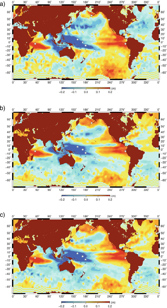
Fig. 1 (a) Sea level anomalies (SLA) for January 1998, TOPEX radar altimetry data. (b)Sealevel
anomalies (SLA) reconstruction for January 1998 using 18 (21) tide gauges with GPS vertical
corrections. Tide gauges used in the reconstruction are depicted as stars.(c) Sea level anomalies
(SLA) reconstruction for January 1998 using 18 (21) tide gauges with GIA model vertical correc-
tions (Peltier, 2004). Tide gauges used in the reconstruction are depicted as stars. Three tide gauges
without GPS or GIA corrections were used for stabilization of the algorithm
A 15-Year Reconstruction of Sea Level Anomalies 361
Fig. 1 (Contd.)
362 N. Schön et al.
(1987) to its end in 2001. An exception is Pohnpei, where a strong positive trend is
derived from the GPS time series. Careful examination of the PSMSL time series
suggests that the strong uplift signal is the result of a recent process and that the
GPS correction should be applied only from 1999 onwards.
3 Comparison of GIA vs. GPS Corrections
The reconstruction results using GPS vertical corrections (Fig. 1b) are compared
with the one using GIA model corrections (Fig. 1c) as well as the original TOPEX
altimetry data (Fig. 1a) for January 1998. Here, t he two dominant signals are the
double tongue-shaped positive anomaly resulting from the 1997/1998 El Niño event,
and the Indian Ocean Dipole event (IOD) (Feng and Meyers, 2003) with its char-
acteristic warming (positive anomaly) in the Indian Ocean, as well as a distinct
cooling (negative anomaly) in the Indonesian/Western Pacific region. Both recon-
structions agree well with the original data, with RMS differences of 3.74 cm (GPS
corrections) and 4.01 cm (GIA corrections), respectively.
In the comparison of the reconstructions, the advantage of the GPS-corrected
reconstruction is most visible in the rendition of the negative anomaly east of
Japan. Also, the intensity of the double tongue (El Niño signal) is reproduced more
distinctly. In contrast, the GIA-corrected reconstruction overestimates the positive
anomalies in the North Atlantic and also shows slightly more negative artifacts
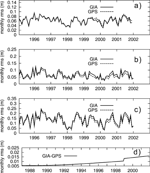
around New Zealand. Figure 2 shows a comparison of monthly RMS values for
both reconstructions. Although, in the global scale (Fig. 2a), the RMS for the GPS
corrections is slightly higher, the regional RMS comparisons for the North Atlantic
(Fig. 2b) and North Pacific (Fig. 2c) show the overall improvement from the GPS
correction.
In the Southern Pacific region, the GIA-corrected gives a better result. This may
be due to the fact that some of the GPS trends used were derived from short time
series (see Schöne et al., 2009). A recalculation has now produced significantly
lower trends for the short time series (D. Thaller, personal communication May,
2009). Hence, the results for the Southern Pacific, as well as the Southern Atlantic,
should be treated with care.
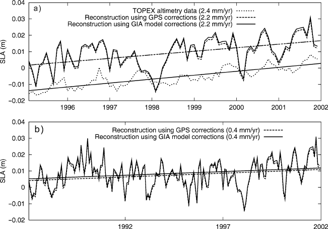
The effect of the GPS vs. GIA corrections on the sea level trend is depicted
in Figure 3. A comparison with the trend extracted from the satellite altimetry data
over the common period (1995–2001) gives a very good agreement (2.2 mm/year vs.
2.4 mm/year); with the GPS-corrected reconstruction slightly closer to the altimetry
data over the whole period. The 21 uncorrected tide gauges used in the reconstruc-
tion give a considerably higher trend of 3.1 cm/year for the same period. The fact
that the rendition of the seasonal cycle is not yet satisfactory is most probably due
to the small number of tide gauges used. The lack of gauges causes an erroneous
overestimation of anomalies, resulting in a noisy reconstruction (see also Chambers
et al., 2002). The trend for the whole 15-year reconstruction period (1987–2001), is
comparably low at only 0.4 mm/year for both corrections, compared to 3.6 mm/year
A 15-Year Reconstruction of Sea Level Anomalies 363
Fig. 2 Monthly RMS time series for TOPEX/Poseidon – GPS/GIA, resp. (a) global (b)North
Atlantic (50
◦
–20
◦
Lat, 280
◦
–360
◦
Lon) (c) North Pacific (50
◦
–30
◦
Lat, 150
◦
–210
◦
Lon) (d)RMS
difference GIA-GPS. The jump in 1999 marks the application of the Pohnpei GPS correction
from the tide gauges alone. It remains to be seen whether this low rate holds when
more land movement data becomes available, or whether it is, at least in part, caused
by an instability of the algorithm.
4 Conclusion
GPS corrections can markedly improve the quality of an SLA reconstruction pro-
vided that enough tide gauges are available. Especially in the North Atlantic and
North Pacific, a regional improvement can be achieved (see also Snay et al., 2007).
Results for the Southern Oceans must be treated with care due to the insufficient
length of GPS time series in this area (see also Blewitt and Lavallée, 2002).
Acknowledgments The author would like to thank Daniela Thaller for providing the GPS data,
as well as for her overall help and expertise. This is publication no. GEOTECH-1251 of the
GEOTECHNOLOGIEN programme of BMBF, grant 03F0434A.
364 N. Schön et al.
Fig. 3 (a) A comparison of global SLA trends for the 1995–2001 period. (b) Global SLA trends
for the 1987–2001 period
References
Blewitt G, Lavallée D (2002) Effect of annual signals on geodetic velocity. J. Geophys. Res.
107(B7), doi: 10.1029/2001JB000570.
Chambers DP, Melhaff CA, Urban TJ, Fuji D, Nerem RS (2002) Low-frequency variations in
global mean sea level: 1950–2000. J. Geophys. Res. 107(C4), 3026–3035.
Church A, White NJ, Coleman R, Lambeck K, Mitrovica JX (2004) Estimates of the regional
distribution of sea level rise over the 1950–2000 period. J. Clim. 17, 2609–2625.
Davis JL, Mitrovica JX (1996) Glacial isostatic adjustment and the anomalous tide gauge record
of eastern North America. Nature 379, 331–333.
Douglas BC (2001) Sea level change in the era of the recording tide gauge. In: Douglas BC,
Kearney MS, Leatherman SP (eds.), Sea Level Rise – History and Consequences, Academic
Press, New York, pp. 37–64.
Feng M, Meyers G (2003) Interannual variability in the tropical Indian Ocean: a two-year time-
scale of Indian Ocean Dipole. Deep-Sea Res. II 50, 2263–2284.
Kaplan A, Kushnir Y, Cane MA, Blumenthal MB (1997) Reduced space optimal analysis for
historical data sets: 136 years of Atlantic sea surface temperatures. J. Geophys. Res. 102,
27835–27860.
Lambeck K, Johnston P, Smither C (1998) Sea-level change, glacial rebound and mantle viscosity
for northern Europe. Geophys. J. Int. 134, 102–144.
Peltier WR (2004) Global glacial isostasy and the surface of the ice-age earth: the ICE-5G (VM2)
Model and GRACE, Ann. Rev. Earth Planet. Sci. 32, 111–149.
Schöne T, Schön N, Thaller D (2009) IGS tide gauge benchmark monitoring pilot project (TIGA):
scientific benefits. J. Geod. 83(3–4), March 2008, doi: 10.1007/s00190-008-0269-y.
Snay R, Cline M, Dillinger W, Foote R, Hilla S, Kass W, Ray J, Rohde J, Sella G, Soler T (2007)