Flechtner F.M., Gruber Th., G?ntner A., Mandea M., Rothacher M., Sch?ne T., Wickert J. (Eds.) System Earth via Geodetic-Geophysical Space Techniques
Подождите немного. Документ загружается.

Radar Altimetry Derived Sea Level Anomalies 323
for ERS-1 and ERS-2, by NASA/CNES for TOPEX/Poseidon and JASON-1, and by NOAA for
GEOSAT. This i s publication no. GEOTECH-1252 of the GEOTECHNOLOGIEN programme of
BMBF, grant 03F0434A. Altimetry and orbit data is available through the ADS system at GFZ
http://adsc.gfz-potsdam.de/ads.
References
Ablain M, Cazenave A, Valladeau G, Guinehut S (2009) A new assessment of global mean sea
level from altimeters highlights a reduction of global trend from 2005 to 2008. Ocean Sci.
Discuss. 6, 31–56.
AVISO (2008) SMM-MU-M5-OP-13184-CN, Edition 4.1, October 2008, http://www.aviso.
oceanobs.com/fileadmin/documents/data/tools/hdbk_j1_gdr.pdf
Biancale R, Bode A (2006) Mean annual and seasonal atmospheric tide models based on 3-
hourly and 6-hourly ECMWF surface pressure data. GFZ Scientific Technical Report 06/01,
doi: 10.2312/GFZ.b103-06011.
Boucher C, Altamimi Z, Sillard P, Feissel-Vernier M (2004) The ITRF2000. IERS Technical Note,
No. 31.
Flechtner F, Schmidt R, Meyer U, Schöne T, Esselborn S, Förste C, Stubenvoll R, Rudenko S,
Neumayer KH, Rothacher M, König R (2006) The benefit of EIGEN gravity field models
for altimetry and vice versa. In: International Symposium on “15 Years of Progress in Radar
Altimetry” Symposium (Venice 2006).
Foerste C, Schmidt R, Stubenvoll R, Flechtner F, Meyer U, König R, Neumayer H,
Biancale R, Lemoine JM, Bruinsma S, Loyer S, Barthelmes F, Esselborn S (2008) The
GeoForschungsZentrum Potsdam/Groupe de Recherche de Geodesie Spatiale satellite-only and
combined gravity field models: EIGEN-GL04S1 and EIGEN-GL04C. J. Geod. 82(6), 331–346,
doi: 10.1007/s00190-007-0183-8.
GEOSAT Handbook (1997) http://ibis.grdl.noaa.gov/SAT/gdrs/geosat_handbook
Hedin AE (1987) MSIS-86 thermospheric model. JGR 92, 4649–4662.
Hopfield HS (1969) Two-quadratic tropospheric refractivity profile for correction satellite data.
JGR 74(18), 4487–4499.
Knocke P, Ries J (1987) Earth radiation pressure effects on satellites. Technical
Memorandum CSR-TM-87–01. Center for Space Research, The University of Texas at
Austin, USA.
Letellier T (2004) Etude des ondes de marée sur les plateux continentaux. Thèse doctorale,
Université de Toulouse III, Ecole Doctorale des Sciences de l’Univers, de l’Environnement
et de l’Espace, 237 pp.
Marini JW, Murray CW (1973) Correction of laser range tracking data for atmospheric refraction
at elevations above 10 degrees. NASA GSFC X-591-73-351.
Massmann FH, Neumayer KH, Raimondo JC, Enninghost K, Li H (1997) Quality of the D-PAF
ERS orbits before and after inclusion of PRARE data. Proceedings of the 3rd ERS Symposium
on Space at the service of our Environment, Florence, Italy, 17–21 March 1997, ESA SP-414,
3Vols.
McCarthy DD, Petit G (eds.) (2003) IERS Conventions. IERS Technical Note 32.
Pearlman MR, Degnan JJ, Bosworth JM (2002) The international laser ranging service. Adv. Space
Res. 30(2), 135–143, doi: 10.1016/S0273-1177(02)00277-6.
Rudenko S, Schöne T (2007) Influence of parameterization on the accuracy of altimetry satellite
orbits. Geophy. Res. Abstr. 9, 07492.
Rudenko S, Schöne T, Gendt G, Zhang F, Thaller D (2007) Precise orbits of altimetry satellites
and analysis of GPS data at tide gauges for sea level research. In: Observations of the System
Earth from Space: status seminar, 22–23 November 2007, Bavarian Academy of Sciences and
Humanities, Munich; Programme & Abstracts, Koordinierungsbüro GEOTECHNOLOGIEN,
41–46.
324 T. Schöne et al.
Rudenko S, Schöne T, Raimondo JC (2006) Precise orbits of altimetry satellites ERS-1, ERS-2 and
TOPEX/Poseidon. In: International Symposium on “15 Years of Progress in Radar Altimetry”
(Venice 2006).
Scharroo R, Schrama EJO, Naeije M, Benveniste J (2000) A recipe for upgrading ERS altimeter
data. Proceedings of ERS-ENVISAT Symposium, Gothenburg, 2000.
Scharroo R, Lillibridge JL, Smith WHF, Schrama EJO (2004) Cross-calibration and long-term
monitoring of the microwave radiometers of ERS, TOPEX, GFO, Jason, and Envisat. Mar.
Geod. 27, 279–308.
Standish EM (1998) JPL Planetary and Lunar Ephemerides, DE405/LE405, JPL IOM 312.
F-98-048.
Tavernier G, Fagard H, Feissel-Vernier M, Le Bail K, Lemoine F, Noll C, Noomen R, Ries JC,
Soudarin L, Valette JJ, Willis P (2006) The international DORIS service: genesis and early
achievements. In: DORIS Special Issue, P. Willis (ed.), J. Geod. 80(8–11), 403–417, doi:
10.1007/s00190-006-0082-4.

Combining GEOSAT and TOPEX/Poseidon
Data by Means of Data Assimilation
Manfred Wenzel and Jens Schröter
1 Introduction
The global sea level is exceedingly reacting on variations of the climate. A warming
of the world ocean or the melting of large continental ice sheets for example would
lead to a sea level rise that would affect directly a large part of mankind. These
effects are reasonable well studied on the global scale but they are still uncertain on
regional or even local scale. For the period of the TOPEX/Poseidon altimetric mea-
surements Wenzel and Schröter (2006, 2007) showed that the sea level trends vary
substantially in space and time and that they are closely associated with heat and
salt anomalies in the ocean. By assimilating the TOPEX/Poseidon measurements
into a global ocean circulation model they were able to separate the individual parts
contributing to the sea level change (steric effects, oceanic fresh water budget). But
longer time-series of the global distribution of sea level variability are needed to con-
firm these results because the climate-induced decadal and secular sea level changes
may be concealed by seasonal, annual and interannual variations, which may act as
noise masking long-term trends. One step in this direction is to utilize sea surface
height (SSH) data from the GEOSAT altimetric mission (1987–1989) in combina-
tion with the TOPEX/Poseidon data (1993–2000). Both datasets will be assimilated
into a global ocean circulation model. By doing this the data gap between GEOSAT
and TOPEX/Poseidon can be filled in a dynamically consistent manner. We will then
be in a position to separate sea level rise due to inflow of continental waters from
warming of the ocean for a much longer time period and reduce estimation error.
2 Model and Data
For our purpose we use the Hamburg Large Scale Geostrophic model (LSG, Maier-
Reimer and Mikolajewicz, 1991; Maier-Reimer et al., 1993). In conjunction with its
adjoint this model has been used successfully for ocean state estimation (e.g. Wenzel
M. Wenzel (B)
Alfred Wegener Institute for Polar and Marine Research, 27570 Bremerhaven, Germany
e-mail: manfred.wenzel@awi.de
325
F. Flechtner et al. (eds.), System Earth via Geodetic-Geophysical Space Techniques,
Advanced Technologies in Earth Sciences, DOI 10.1007/978-3-642-10228-8_26,
C
Springer-Verlag Berlin Heidelberg 2010
326 M. Wenzel and J. Schröter
and Schröter, 2006, 2007). It has 2 × 2 degree horizontal resolution, 23 vertical
layers (varying from 20 m thickness for the top layer to 750 m for the deepest ones)
and the implicit formulation in time allows for a time step of 10 days. The uti-
lized global OGCM has a free surface. Mass conservation is achieved by taking into
account the volume and mass of the surface freshwater flux as well as by includ-
ing the steric effects of thermal expansion and haline contraction. This offers the
possibility to combine altimetric measurements with hydrographic data in a dynam-
ically consistent manner. Details about the assimilation procedure can be found e.g.
in Hellmer et al. (2005).
Here we perform two assimilation experiments. First we make use of all available
data from altimetry of both satellite missions called GEOSAT-TOPEX/Poseidon
(GETO). It is mostly a substantial extension of the previous work reported in
Hellmer et al. (2005) and Wenzel and Schröter (2007). The relative reference
between the satellite altimeters is uncertain, as there was no period of overlap.
We accept this fact by referencing GEOSAT to its own temporal mean. The gap
to TOPEX/Poseidon is filled by the ocean model. As it turned out the results for this
gap were not satisfactorily and a second assimilation experiment was performed
using additional data.
The only continuous dataset for sea level for the whole assimilation period is land
based and consists of tide gauge records. In a preliminary study it was found that
the direct use of sea level time series at tide gauge stations has only little influence
on the general model behaviour. There are simply too many reasonable dynamically
consistent solutions for a local sea level that are the effect of regional changes in
wind forcing or local density variations in the ocean which are inside the observed
variability We therefore produced a global dataset for sea surface height which is
reconstructed from tide gauges and observed variability patterns as measured by
TOPEX/Poseidon in analogy to the study by Church and White (2006). The second
experiment is then denoted GEOSAT-TOPEX/Poseidon-Reconstructed (GETORC).
Let us next describe the datasets used in the experiment GETO in detail:
• Monthly sea surface temperatures (SST) for the period 1987–2000 (Reynolds
et al., 2002).
• Gridded fields of 10 day averages of sea surface height anomalies (SSHA)
as measured by the TOPEX/Poseidon altimetric mission for the period
1993–2000, provided by GeoForschungsZentrum Potsdam (GFZ; S. Esselborn,
pers. communication). These anomalies are combined with the SHOM98.2
mean sea surface height (MSSH; available online at the time of writ-
ing at: http://www.cls.fr/html/oceano/projets/mss/cls_shom_en.html) referenced
to the EIGEN-GRACE01S geoid (available online at the time of writing
at: http://www.gfz-potsdam.de/grace/results/grav/g001_eigen-grace01s.html)to
give absolute dynamic height values.
• Preliminary re-processed gridded fields of 10 day averages of sea surface
height anomalies (SSHA) as measured by the GEOSAT altimetric mission for
the period 1987–1989, provided by GeoForschungsZentrum Potsdam (chapter
“Radar Altimetry Derived Sea Level Anomalies – The Benefit of New Orbits
Combining GEOSAT and TOPEX/Poseidon Data by Means of Data Assimilation 327
and Harmonization” by Schöne et al., 2009, this issue). These anomalies are
referenced to their own temporal mean.
• Temporal mean transports of mass, freshwater and heat as obtained by differ-
ent authors and as they are summarized e.g. by Bryden and Imawaki (2001)
and by Wijffels (2001). Transport constraints are not applied for the Antarctic
Circumpolar Current (ACC).
• The climatological mean temperatures and salinities from the WOCE Global
Hydrographic Climatology (WGHC; Gouretski and Koltermann, 2004) in com-
bination with the mean annual cycle from the World Ocean Atlas (WOA01;
Conkright et al., 2002). These data are supplied to the assimilation procedure
with small weights thus serving only as background information.
• The mean annual cycle of temperatures, salinities and horizontal velocities on
two sections in the Weddell Sea area and on four sections in the Ross Sea.
These data are taken from high resolution model experiments of the Weddell
Sea (Schodlok et al., 2002) and the Ross Sea (Assmann and Timmermann, 2005)
whose water mass characteristics and circulation are in good agreement with local
observations.
In the second experiment GETORC, we additionally use SSHA fields that
are reconstructed from tide gauges and an EOF basis deduced from the
TOPEX/Poseidon data, in analogy to Church and White (2006). These data will
be applied for the whole period 1987–2000.
3 Results
The data assimilation produces minor changes in atmospheric forcing which is in
agreement with observed atmospheric variability. Further, the initial temperature
and salinity fields of the ocean can be adjusted. Both changes result in a tem-
poral evolution of the modelled ocean which is as close to the observations in
space and time as possible and follows the exact model equations. All ocean fields
are in dynamic equilibrium and data counterparts can be modelled in satisfactory
agreement with the observed values. It is found that the initial state has only little
influence on the evolution. The most important changes are in the wind and thermal
forcing. Freshwater fluxes have small local effects, however their global integral
directly influences the global sea level variation.
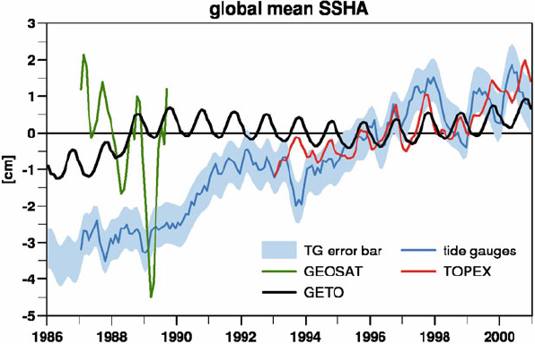
Figure 1 shows the modelled global mean sea level anomaly (GMSLA) after
assimilation for the experiment GETO in comparison to the above mentioned
satellite measurements. While the model reproduces the GMSLA derived from
TOPEX/Poseidon quite well this is not the case for GEOSAT. Even the trend
during the period 1987–1989 is not reproduced. The model prefers a positive
trend while the data show a negative one. Anyhow, the modelled positive trend
seems to be more realistic to some extent as one can conclude from the GMSLA
reconstructed by Church and White (2006) from tide gauge records that shows a
positive trend throughout the period 1986–2000. Furthermore, Fig. 1 shows that
from hydrographical data alone the assimilation has no reason to produce a sea
328 M. Wenzel and J. Schröter
Fig. 1 Temporal evolution of the global mean of the sea level anomaly from assimilation exper-
iment GETO compared to the satellite data used. Because the GEOSAT data are anomalies only
with no own reference, they are adjusted to have the same temporal mean as the model solution.
For comparison the SSHA data reconstructed from tide gauges (blue curve) are included together
with the error bars (blue shading) taken from Church and White (2006)
level rise as strong as given by Church and White (2006), although its steric part
during this period appears to be reasonable. To demonstrate the latter Fig. 2 shows
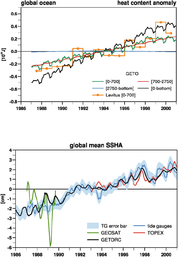
the evolution of the oceans heat content from experiment GETO. Its trend fits well
to the results of Levitus et al. (2005). Therefore, the missing part must contribute to
the oceanic fresh water budget (eustatic sea level change) that remains unrestricted
during most of the assimilation period as long as the models SSHA is constrained by
data only for disconnected sub-periods that do not have a common reference, i.e. as
for TOPEX/Poseidon an absolute reference is needed for the GEOSAT data before
reliable statements are possible for the past 20 years. Another possibility to improve
the situation would be to link the different SSHA datasets by additional information
about the evolution of the sea level during the whole assimilation period.
Consequently we produced the second experiment GETORC. The SSHA data
reconstructed from tide gauges are utilized as additional information during the
whole assimilation period. Also for GETORC the negative trend from the GEOSAT
data during 1987–1989 is not reproduced (Fig. 3). Nevertheless, now the tem-
poral evolution of the GMSLA fits well to the one given by Church and White
(2006) for the whole period 1987–2000. Beside this, during the time with the
TOPEX/Poseidon SSHA employed (1993–2000) it is even further improved. This
improvement is not only confined to the GMSLA. It also applies to the spatial
structure of the sea level. The root mean square (RMS) value for the difference
between the modelled SSH and the data is only slightly smaller for GETORC than
for GETO during the GEOSAT period (1987–1989), but it is significantly reduced
Combining GEOSAT and TOPEX/Poseidon Data by Means of Data Assimilation 329
Fig. 2 Temporal evolution of the global oceans heat content anomaly for the depth ranges
[0–700 m], [700–2,750 m] and [2,750 m-bottom]. For the upper 700 m the corresponding annual
mean values derived from Levitus et al. (2005) are included
Fig. 3 Temporal evolution of the global mean of the sea level anomaly from assimilation exper-
iment GETORC compared to the satellite data used. Note that in this experiment the SSHA data
reconstructed from the tide gauges are assimilated!
for the TOPEX/Poseidon period (Fig. 4a, b). In general the RMS differences now
coincide approximately with the values that result from the differences between the
SSHA data derived from altimeter and the ones reconstructed from tide gauges.
Accordingly the spatial correlations between model and data have increased for

330 M. Wenzel and J. Schröter
Fig. 4 Upper row: temporal evolution of the spatial RSM of the difference between the model
SSHA and the data. Lower row: the corresponding correlations for the two experiments GETO
(left: a, c)andGETORC(right: b, d). For comparison the light grey shading gives the corre-
sponding values for the difference between the tide gauge reconstruction and the satellite data
both periods (Fig. 4c, d). Both facts strongly indicate that the model solution profits
from assimilating this additional dataset that bridges the gap between GEOSAT and
TOPEX/Poseidon.
To analyse the regional distribution of the modelled sea level trend (Fig. 5) in
more detail it is dissected into the parts that stem from the eustatic contribution, i.e.
the ocean fresh water budget, and from the steric effects, i.e. thermal expansion and
haline contraction. On global average the eustatic part (Fig. 5b) contributes about
two thirds (1.98 mm/year) to the total sea level rise (2.95 mm/year, Fig. 5a) although
on regional to local scale it is less important than the thermosteric (Fig. 5c) and the
halosteric part (Fig. 5d). Both, the thermosteric and the halosteric changes, are of
the same order of magnitude locally and they nearly compensate in large parts of
the world ocean, as has been demonstrated already by Wenzel and Schröter (2006,
2007), whereas on global average the halosteric trend is negligible (0.05 mm/year)
compared to the thermosteric (0.92 mm/year).
A further inspection of the results on a global scale shows, that about half of
the thermosteric sea level rise stems from an upper ocean warming (0–700 m). The
development of the heat content of this layer (Fig. 6a) is mainly constrained via the
sea surface temperature and by the climatological hydrographic annual cycle and it
fits well to the estimates of Levitus et al. (2005), even better than for experiment
GETO (Fig. 2). In the lower depth ranges (700–2,750 m and 2,750 m-bottom) we
find ocean warming, an increasing heat content too. Both layers add about one quar-
ter to the total heat surplus each, i.e. together as much as the upper 700 m. Thus, the

Combining GEOSAT and TOPEX/Poseidon Data by Means of Data Assimilation 331
Fig. 5 (a) Local sea level trend dissected into its (b) eustatic, (c) thermosteric and (d)halosteric
contribution. Note the enlarged colour scale for the eustatic part!
Fig. 6 (a) Temporal evolution of the global oceans heat content anomaly for the experiment
GETORC as in Fig. 2, (b) the resulting global mean sea level anomaly dissected into its
thermosteric, halosteric and eustatic contribution
deep ocean adds an essential contribution to the total (thermo)steric sea level rise.
In any case, the global steric sea level variations give only about one third of the
total trend. The subordinate importance of the steric trend compared to the eustatic
during this period has already been stressed by Jevrejeva et al. (2008). Furthermore,
in comparison with the eustatic variations, the steric show a much weaker annual
cycle that is out of phase (Fig. 6b), a well known result from hydrology.
4 Summary and Conclusions
In order to assess the sea level rise for periods longer than the continuous observa-
tions by TOPEX/Poseidon we performed two assimilation experiments. Both use the
GEOSAT mission data additionally and bridge the gap between these observations
332 M. Wenzel and J. Schröter
in a dynamically consistent manner in accordance with standard ocean observations.
It is found that the global fresh water fluxes of the ocean remain uncertain to such an
extent that the evolution of the sea level cannot be concluded from measurements
of fluxes or estimates of land ice melting. Without continuous records of the sea
level no reliable estimates can be made, as has been demonstrated in the experiment
GETO.
We therefore used additional observations provided by time series of sea level at
tide gauges. From these data global maps of sea level anomalies were constructed
using the EOF technique applied in Church and White (2006). These maps are sub-
sequently assimilated in addition to the sea surface height anomalies from altimetry.
Experiment GETORC then provides the answer to the total sea level rise and to
its temporally and spatially varying contributions. Ocean warming accounts for
one third of global sea level rise by steric expansion. Half of it is confined to the
upper 700 m of the ocean, in good agreements with the independent analysis of
Levitus et al. (2005). The other half of oceanic thermosteric expansion is found in
equal parts above and below the depth of 2,750 m. That is we diagnose very strong
warming of the deep ocean which cannot be deducted from the very sparse in situ
observations alone. In addition to warming of the ocean we find an inflow of fresh
water with amplitude close to 2 mm/year. This value is also on the high side but it is
supported by the analysis of Jevrejeva et al. (2008). Wrapping up we can conclude
that a relative reference has been found between the satellite missions GEOSAT and
TOPEX/Poseidon which is physically reasonable and in accordance with oceanic
observations, in particular tide gauge records.
Acknowledgement This is publication no. GEOTECH-1253 of the GEOTECHNOLOGIEN pro-
gramme of BMBF, grant 03F0434B. We are grateful to the anonymous reviewer for helpful
comments and suggestions.
References
Assmann KM, Timmermann R (2005) Variability of dense water formation in the Ross Sea. Ocean
Dyn. 55(2), 68–87, doi: 10.1007/s10236-004-0106-7.
Bryden HL, Imawaki S (2001) Ocean heat transport. In: Siedler G, Church J, Gould J (ed.), Ocean
Circulation and Climate, Academic Press, New York, International Geophysics Series Vol. 77,
pp. 455–474.
Church JA, White NJ (2006) A 20th century acceleration in global sea-level rise. Geophys. Res.
Lett. 33, L01602, doi: 10.1029/2005GL024826.
Conkright ME et al. (2002) World Ocean Atlas 2001: objective analysis, data statistics and figures,
CD-ROM Documentation, National Oceanographic Data Center, Silver Springs, MD, 17 pp.
Gouretski VV, Koltermann KP (2004) WOCE Global Hydrographic Climatology, A Technical
Report, Berichte des Bundesamtes für Seeschifffahrt und Hydrographie, No. 35, 50 pp + 2
CD-ROM
Hellmer HH, Schodlok MP, Wenzel M, Schröter J (2005) On the influence of adequate Weddell
Sea characteristics in a large-scale global ocean circulation model. Ocean Dyn. 55, 88–99.
Jevrejeva S, Moore JC, Grinstead A (2008) Relative importance of mass and volume changes to
global sea level rise. J. Geophys. Res. 113, D08105, doi: 10.1029/2007JD009208.
Maier-Reimer E, Mikolajewicz U (1991) The Hamburg large scale geostrophic ocean general
circulation model (Cycle 1), Technical Report, 2, Deutsches Klimarechenzentrum, Hamburg