Flechtner F.M., Gruber Th., G?ntner A., Mandea M., Rothacher M., Sch?ne T., Wickert J. (Eds.) System Earth via Geodetic-Geophysical Space Techniques
Подождите немного. Документ загружается.

Combining GEOSAT and TOPEX/Poseidon Data by Means of Data Assimilation 333
Maier-Reimer E, Mikolajewicz U, Hasselmann K (1993) Mean circulation of the Hamburg LSG
OGCM and its sensitivity to the thermohaline surface forcing. J. Phy. Oceanogr. 23, 731–757.
Levitus S, Antonov J, Boyer T (2005) Warming of the world ocean, 1955–2003. Geophys. Res.
Lett. 32, L02604, doi: 10.1029/2004GL021592.
Reynolds RW et al. (2002) An improved in situ and satellite SST analysis for climate. J. Clim. 15,
1609–1625.
Schodlok MP et al. (2002) On the transport, variability, and origin of dense water masses crossing
the South Scotia Ridge. Deep Sea Res. II 49, 4807–4825.
Wenzel M, Schröter J (2006) Understanding measured sea level rise by data assimilation. In:
“Proceedings of the Symposium on 15 Year of Progress in Radar Altimetry”, SP-614, ESA
Publication Division, Noordwijk, The Netherlands, ISBN 92-9092-925-1, ISSN 1609-042X,
CD-ROM.
Wenzel M, Schröter J (2007) The global ocean mass budget in 1993–2003 estimated from sea level
change. J. Phy. Oceanogr. 37(2), 203–213, doi: 10.1175/JPO3007.1.
Wijffels SE (2001) Ocean transport of fresh water. In: Siedler G, Church J, Gould J (eds.), Ocean
Circulation and Climate, Academic Press, New York, International Geophysics Series Vol. 77,
pp. 475–488.

Reanalysis of GPS Data at Tide Gauges
and the Combination for the IGS TIGA
Pilot Project
Sergei Rudenko, Daniela Thaller, Gerd Gendt,
Michael Dähnn, and Tilo Schöne
1 Introduction
Analysis of tide gauge measurements for sea level change research requires a well
defined reference frame. Such reference frame can be realized through precise posi-
tions of GPS stations located at or near tide gauge benchmarks. Establishment,
maintenance and expansion of the network of GPS stations at tide gauges and estab-
lishment of such a reference frame are the primary purposes of the IGS GPS Tide
Gauge Benchmark Monitoring Pilot Project (TIGA) (Schöne et al., 2009). Presently,
six TIGA analysis centres (TAC) contribute to the project, namely, Geoscience
Australia (AUT), a consortium of University of Canberra, University of Tasmania
and Australian National University (CTA), German Geodetic Research Institute
(DGF), EUREF (ETG) through Federal Agency for Cartography and Geodesy
(Germany), German Research Centre for Geosciences (GFT) and University La
Rochelle (ULR). Three TAC (CTA, GFT and ULR) contribute with global station
network solutions, whereas AUT, DGF and ETG provide regional station network
solutions for the regions Pacific/Australia/Antarctica, Atlantic and Europe, respec-
tively. Different TAC provided their solutions in 2002–2006. However, with the
switch within the IGS from using a relative model for antenna phase centre vari-
ations (PCV) to an absolute PCV model primarily affecting the station height a
reprocessing became necessary within the TIGA project.
2 Reprocessing of GPS Data at Tide Gauge Benchmarks
at GFT
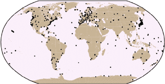
GPS data of the global network of 403 GPS stations (Fig. 1) at the time interval
from March 1998 till December 2007 were processed using EPOS-PV2 soft-
ware (Gendt et al., 1994) improved in the recent years. The main improvements
S. Rudenko (B)
Helmholtz Centre Potsdam, GFZ German Research Centre for Geosciences,
Department 1: Geodesy and Remote Sensing, Telegrafenberg, 14473 Potsdam, Germany
e-mail: sergei.rudenko@gfz-potsdam.de
335
F. Flechtner et al. (eds.), System Earth via Geodetic-Geophysical Space Techniques,
Advanced Technologies in Earth Sciences, DOI 10.1007/978-3-642-10228-8_27,
C
Springer-Verlag Berlin Heidelberg 2010
336 S. Rudenko et al.
Fig. 1 Global station distribution of the GFT solution
include use of the absolute PCV model, implementation of IERS Conventions 2003
(McCarthy and Petit, 2004), development of a new ambiguity fixing scheme allow-
ing to fix 95 vs. 80% of ambiguities (Ge et al., 2005), implementation of a new
data processing strategy for huge GNSS networks (Ge et al., 2006) allowing to
process GPS data from a few hundred stations in one network solution and other
improvements.
The GPS analysis follows the scheme described in Zhang et al. (2007) with the
following modifications. The absolute PCV model is used instead of relative one.
The total number of stations in the GFT solution increased from 372 (Zhang et al.,
2008) to 403 by adding 31 new TIGA stations located in Europe, Asia, Africa,
Australia, Pacific, North and South America. The global network of GPS stations
includes 216 IGS stations and 187 GPS TIGA stations. ITRF2005 (Altamimi et al.,
2007) is used as a priori reference frame. Initial coordinates of 197 stations not
present in the ITRF2005 are estimated ones and their velocities are computed using
NNR-NUVEL1A model (McCarthy and Petit, 2004). A procedure based on the
GFZ rapid product generation was created to compute satellite clocks using the
global network of up to 98 IGS stations. The derived satellite clocks and orbits are
used for data cleaning within precise point positioning (PPP), namely, for detecting
cycle slips, outliers and bad observation periods. The EIGEN-GL04S1 Earth gravity
model with the time variations of C20, C30 and C40 is used instead of JGM2. The
Earth gravity model truncation level increased from 8 to 12.
The final results are given in the SINEX format and include weekly sets of GPS
station coordinates, daily values of Earth rotation parameters and their rates, as well
as satellite antenna offsets. The mean value of RMS fits of L3 ionosphere-free linear
combination of phase observables is 6.9 mm.
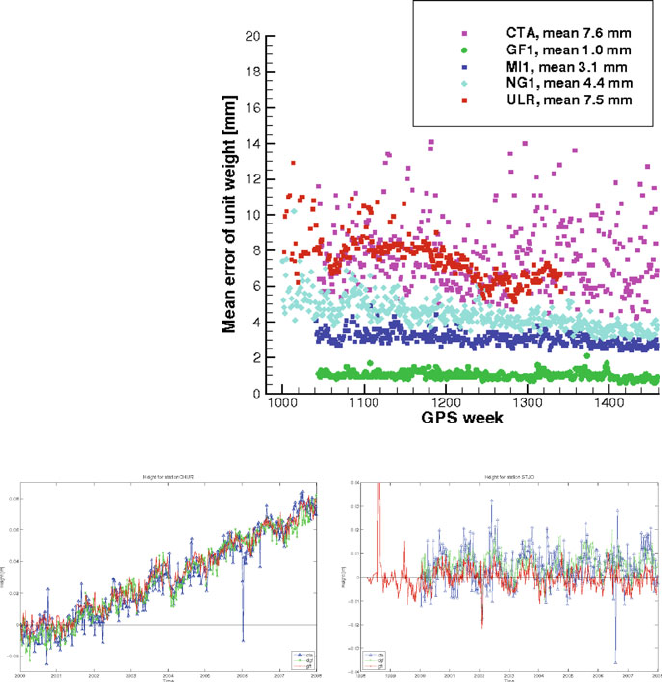
Weekly station coordinates of the GFT solution were compared with those of the
solutions of two TACs, namely, CTA and ULR, and with the solutions of three IGS
Analysis Centres (AC), namely, GFZ (GF1), Massachusetts Institute of Technology,
USA (MI1) and National Geodetic Survey, NOAA, USA (NG1) ACs (Fig. 2). The
Reanalysis of GPS Data at Tide Gauges 337
Fig. 2 Comparison of
weekly station coordinates of
the GFT solution and the
solutions of other TIGA and
IGS analysis centres
Fig. 3 Time series of station heights derived from the individual TAC solutions for two TIGA sites
mean RMS difference of station coordinates of GFT and GF1 solutions is 1.0 mm,
and of GFT and four other IGS and TIGA AC solutions is 3–8 mm. The differ-
ences can be caused by using different models, software packages, data processing
strategies, etc.
Figure 3 shows the time series of station height derived from the GFT solu-
tion in the comparison with two other TIGA analysis center solutions, namely,
CTA and DGF. The temporal behavior agrees quite well. After removing the linear
trend (10.2 mm/year for the GFT solution) from the time series of station CHUR
(Churchill, Canada), the weighted RMS values of the residuals are 8.1, 6.0 and
5.5 mm for the CTA, DGF and GFT solution, respectively. In the case of STJO
(St. John’s, Canada), the vertical trend is much smaller (–0.2 mm/year for the
GFT solution). The weighted RMS values are 7.3, 4.1 and 6.4 mm for the three
series.

338 S. Rudenko et al.
3 Combination of Weekly TIGA Solutions
As the TACs perform the processing on a best-effort basis, not all could manage it
to fully reprocess all data. Table 1 summarizes the actual status of the reprocessed
solutions (20/10/2009).
In order to minimize the so-called analysis noise and to provide station
coordinates for all TIGA observing stations (TOS) in one common reference
frame, a combination of the individual contributions is indispensable. Hence, a
similar procedure that is already applied for the official weekly IGS product
(see Ferland et al., 2005) is done for the TIGA project as well. The individ-
ual contributions are provided as weekly solutions using the SINEX format, so
that the full variance-covariance matrix and the information on a priori con-
straints are provided in addition to the solution itself. Therefore, it is possi-
ble to fully remove the constraints applied to the individual contributions, i.e.
mainly datum definition, and, thus, to derive datum-free normal equation sys-
tems (NEQs). The availability of datum-free NEQs is the precondition for a
rigorous combination of all TAC contributions. The combination is done using
the Bernese GPS Software version 5.0 (Dach et al., 2007) with further mod-
ifications implemented at GFZ in order to be able to handle all contributions
as best as possible. The weekly combined solutions are aligned to the IGS
realization of the ITRF2005 (Altamimi et al., 2007) using no-net-rotation and
no-net-translation conditions for the set of reference frame stations used within
the IGS.
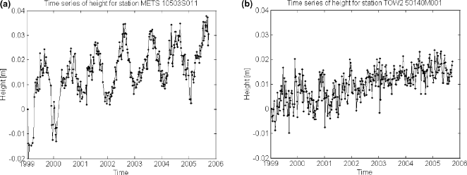
Figure 4 shows the time series of station heights derived from the weekly com-
bined solutions exemplarily for two TOS. Metsahovi (METS, Fig. 4a) is one of
the stations with a clearly pronounced annual signal, e.g. coming from atmo-
spheric or hydrological loading. Contrary, the station Townsville (TOW2; Fig. 4b)
has even almost no annual signal; however, a comparably large linear trend is
visible.
The time-series of combined coordinates of the TOS were used to reconstruct
sea level anomalies and it turned out that the time series perform very well for such
applications (see Schöne et al., 2009).
Table 1 Status of reprocessed TAC contributions that were computed using the new IGS standards
TAC First week Last week
No. of weeks
available
No. of weeks
missing No. of stations
AUT 0887 1,512 626 0 ∼80
CTA 1,043 1,474 432 0 ∼130
DGF 1,043 1,511 469 0 ∼60
ETG 1,400 1,548 149 0 ∼40
GFT 939 1,459 515 6 ∼400
ULR 834 1,511 678 0 ∼300
Reanalysis of GPS Data at Tide Gauges 339
Fig. 4 Time series of weekly combined station heights for Metsahovi (METS) and Townsville
(TOW2)
4 Summary and Conclusions
Reanalysis of GPS data at tide gauges allows establishing a reference frame to be
used to correct tide gauge measurements and tie them to the ITRF. GPS data of
stations located at or near tide gauge benchmarks (TIGA stations) have been repro-
cessed at six TIGA analysis centres. The improvements and results of reprocessing
of GPS data from the global network of 403 stations at the time span from March
1998 till December 2007 at GFT TAC are described. The mean RMS difference
of weekly station coordinates of GFT and GFZ IGS AC solutions is 1.0 mm, and
of GFT solution and the solutions of four other IGS and TIGA ACs is 3–8 mm.
The procedure and some results of the combination of the solutions of six TACs
are given.
Acknowledgments Use of GPS data from IGS (Dow et al., 2005) and TIGA stations is acknowl-
edged. We are grateful to F. Zhang, M. Ge, Th. Nischan and A. Brandt for useful discussions and
some help and to the anonymous reviewer for the comments improved the paper. This publica-
tion no. GEOTECH-1250 of the programme GEOTECHNOLOGIEN of the German Ministry of
Education and Research (BMBF), grant 03F0434A.
TAC solutions are available at TIGA web page http://adsc.gfz-potsdam.de/tiga/index_
TIGA.html.
References
Altamimi Z, Collilieux X, Legrand J, Garayt B, Boucher C (2007) ITRF2005: A new release of the
International Terrestrial Reference Frame based on time series of station positions and Earth
Orientation Parameters. J. Geophys. Res. 112, B09401, doi: 10.1029/2007JB004949.
Dach R, Hugentobler U, Fridez P, Meindl M (2007) Bernese GPS Software 5.0, Astronomical
Institute University of Bern, Bern, Switzerland.
340 S. Rudenko et al.
Dow J, Neilan R, Gendt G (2005) The International GPS Service: Celebrating the 10th anniver-
sary and looking to the next decade. Adv. Space Res. 36(3), 320–326, doi: 10.1016/
j.asr.2005.05.125.
Ferland R, Gendt G, Schöne T (2005) IGS reference frame maintenance. In: Meindl M (ed.),
Celebrating a Decade of the International GPS Service, Workshop and Symposium 2004,
Proceedings. Astronomical Institute University of Bern, Switzerland.
Ge M, Gendt G, Dick G, Zhang FP (2005) Improving carrier-phase ambiguity resolution in global
GPS network solutions. J. Geod. 79, 103–110, doi: 20.2007/s00290-005-0447-0.
Ge M, Gendt G, Dick G, Zhang FP, Rothacher M (2006) A new data processing strategy for huge
GNSS networks. J. Geod. 80, 199–203, doi: 10.1007/s00190-006-0044-x.
Gendt G, Dick G, Mai W, Nischan T, Sommerfeld W (1994) Nutzerhandbuch zum
Programmsystem EPOS.P.V2 (Earth Parameters and Orbit determination System) für die
Analyse von GPS-daten. GeoForschungsZentrum Potsdam, Bereich “Rezente Kinematik und
Dynamik der Erde”, February 18, 1994.
McCarthy D, Petit G (2004) IERS Conventions (2003). IERS Technical Note 32.
Schöne T, Schön N, Thaller D (2009) IGS tide gauge benchmark monitoring pilot project (TIGA):
Scientific benefits. J. Geod. 83, 249–261, doi: 10.1007/s00190-008-0269-y.
Zhang F, Gendt G, Ge M (2007) GPS data processing at GFZ for monitoring the vertical
motion of global tide gauge benchmarks: Technical report for projects TIGA and SEAL.
GeoForschungsZentrum Potsdam Scientific Technical Report STR07/02, 28p.
Zhang F, Wünsch J, van Dam T, Gendt G, Ge M, Schöne T (2008) Vertical crustal motion at
tide gauges derived by analyzing GPS time series. GeoForschungsZentrum Potsdam Scientific
Technical Report STR08/03, 106p.

Sea Level Rise in North Atlantic Derived
from Gap Filled Tide Gauge Stations
of the PSMSL Data Set
Heiko Reinhardt, Dimitry Sidorenko, Manfred Wenzel, and Jens Schröter
1 Introduction
Sea level in the second half of the last century has been observed at a large number of
tide gauges. The major difficulty in deriving a consistent analysis of sea level rise is
caused by temporal data gaps and vertical shifts in tide gauge positions. Additionally
vertical land motion has to be separated from sea level change.
In the past years the tide gauge stations data have been efficiently used for many
coastal and global ocean applications as well as for validation of ocean models.
Thus Jevrejeva et al. (2006) used the global set of gauges to compute the sea
level rise variability for the time period spanned by Permanent Service for Mean
Sea Level (PSMSL, web page http://www.pol.ac.uk/psmsl) data set. They follow
two approaches, one using simple mean of all active gauge stations and the other
using averaging of the next-neighbouring-stations. The resulting global averaged
trend is 1.8 mm/year for the time period 1900–2000. Church et al. (2004) used
PSMSL data set together with TOPEX/POSEIDON satellite mission to estimate
the spatio-temporal pattern for the world ocean leading to an averaged linear trend
of 1.8±0.3 mm/year for the last 50 years. Other works concentrate on regional
applications as exemplified by Zervas (2001) and Holgate and Woodworth (2004).
Most of these studies however neglect the temporal data gaps or just omit such
series from the analysis. Our concern is therefore to reconstruct the missing data.
Including reconstructed series into analysis would serve for the improvement of
the regional distribution of the gauge data. Following we describe the dataset and
present the methods for closing the gaps. The validation of these methods is demon-
strated. The reconstructed data is further used together with IFEOM model to obtain
the spatial trend and variability patterns in the North Atlantic for the period from
1950 to 1994.
H. Reinhardt (B)
Stiftung Alfred Wegener Institut für Polar und Meeresforschung,
27570 Bremerhaven, Germany
e-mail: heiko.reinhardt@awi.de
341
F. Flechtner et al. (eds.), System Earth via Geodetic-Geophysical Space Techniques,
Advanced Technologies in Earth Sciences, DOI 10.1007/978-3-642-10228-8_28,
C
Springer-Verlag Berlin Heidelberg 2010
342 H. Reinhardt et al.
2 The PSMSL Gauge Data Set
Proudman Oceanographic Institute UK maintains the Permanent Service for Mean
Sea Level (PSMSL), and provides us with the revised local referenced data s et
(RLR), consisting of time series of mean monthly sea level at gauge stations in a
common time reference frame.
Gauge stations are mainly confined to the coasts of the continents, mostly Europe
and North America and a few stations on islands in the open ocean. Few stations
show data before 1900. This number increases in decades afterwards. A sufficient
number of active stations can be seen after 1950. We consider the gauge stations in
the region of IFEOM model (the North Atlantic) and the time-span from January
1950 to December 2006. Only the gauges providing time series for longer than
5 years were used.
Each gauge station rests on the ground below it, using it as its local reference
frame. To compare data f rom different tide gauges, shifts in the reference frame
must be corrected for each tide gauge. Land movements are mostly due to glacial
isostatic adjustment (GIA), where the land still moves since the last glacial maxi-
mum 10,000 years ago. Oil or groundwater drilling or constructions near the gauge
stations complicate the situation.
A way to reduce the time series from land movement would be with the help
of GPS signals which can give a very precise value at sensor locations. GPS data
however was not used in this study due to its limited availability at gauge stations
and other drawbacks (see Snay et al., 2007). Results including GPS corrections are
subject of a separate study.
Here, we use a correction for GIA by Peltier, which can be accessed via PSMSL
(see Peltier, 1998). These values are based on theoretical assumptions and neglect
some local effects of land movement.
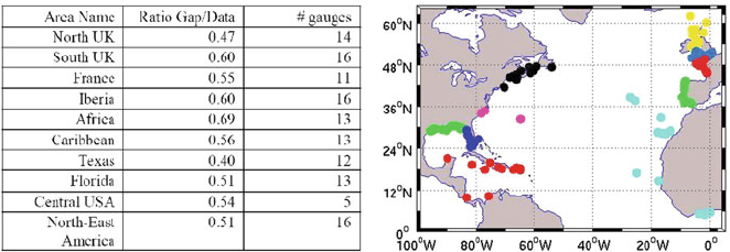
We group the gauge stations of the North Atlantic into 10 regions as shown in
Fig. 1. Typically tide gauges in the same region show similar behaviour expressed
by their covariance structure. This is used in our gap-filling method.
Fig. 1 Regional distribution of the gauge stations in North Atlantic used for gap filling (right)and
details of each region

Sea Level Rise in North Atlantic Derived from Gap Filled Tide Gauge Stations 343
Our grouping of gauges takes into account gauge stations that are lying close
together at the same continental coast line. Exceptions are the regions Caribbean
and Africa. The stations in the Caribbean and on the coast of Central America were
taken into one group due to large data gaps at the end of few time series in these
regions. The stations on the Canaries, Azores islands and African coast were taken
in one group because there are a few stations in that region.
The table within Fig. 1 (left part) summarizes the regions as well as the percent-
age of missing values in the data. The total number of missing values in one region
should not exceed 60% of the total number of data values in that region.
3 Theoretical Background and Used Method
Multi-Channel-Singular-Signal-Analysis (MSSA): The MSSA method is mostly
used for noise reduction, but can be also used for filling of data gaps. This work
strongly relies on Ghil et al. (2002) where a detailed description of MSSA can
be found. MSSA is based on a time lagged grand covariance matrix C, where the
covariance of N time series (channels) each with a lag of M time steps to the other
is calculated according to:
(C
l,l
)
j,j
=
1
˜
N
min (N,N+j−j
)
max (1,1+j−j
)
x
l
(t)x
l
(t + j − j
)
ˇ
N is a normalising factor. l and l
denote the respective time series, j and j
are the
indices of the entries of sub-block matrices. The grand covariance matrix is made
up of N
2
sub matrices each containing a lagged covariance matrix of time series l
and l
.
From Matrix CN∗M eigenvectors ( M for each time signal) and N∗M eigenval-
ues can be calculated. By projecting each time series to the according eigenvector
one gets M∗N principal components (PCs) showing the temporal behaviour. By
projecting the PCs on the according time series one obtains N∗M reconstructed
components (RCs).
Summing over all the according RCs fully reconstructs each time series. Every
RC explains a certain percentage of variance of the time series, given by the nor-
malised eigenvalues. So with the first few RCs the dominant behaviour of the signal
can be explained, while higher RCs can be neglected as noise. This is important for
our gap-filling method, since we try to reconstruct only information for long term
variations in the data gaps and filter the time series after reconstruction.
Method for gap-filling: For gap-filling we considered the years from 1950 to
2006. Our aim was to get consistent time-series for all gauges for this period. The
time series of the gauges are used as channels in MSSA in each region. While a few
gauge stations have data for almost the entire time span, most gauge stations show
large data gaps. There are several possibilities to treat with gaps in time series, the
simplest being linear interpolation thereby neglecting variabilities in the time sig-
nal. Other methods as e.g. EOFs only consider covariances in space, e.g. transform