Elsevier Encyclopedia of Geology - vol I A-E
Подождите немного. Документ загружается.


having experienced greater tectonic stress and have
more pronounced fractures/discontinuities, younger
limestones (such as the Chalk) also have cracks and
hence significant secondary permeability. The high per-
meability results in limited near-surface erosion and
hence the calcareous rocks invariably form uplands
with low groundwater levels. Where the calcium car-
bonate goes into solution, it moves through and may go
out of the limestone mass, leaving extensive openings/
cavesystems, particularly in the older limestones. These
underground karstic features may develop at any level,
depending mainly on the depth of groundwater in the
geological past. Subvertical chimneys are commonly
found connecting the semihorizontal caves. These low-
pressure zones result in preferential percolation, above
which swallow holes and other large surface features
are common. In stronger limestones, the arching effect
usually prevents collapse of the rock, although spec-
tacular hollows have occurred where the roof of an
underground passage has suddenly given way. The infill
of wide solution hollows, such as grykes, swallets, or
pipes, may be subject to sudden washout and may lead
to collapse.
In both the older limestones (such as the Carbon-
iferous Limestone) and the younger Chalk materials,
man-made excavations occur. Although in the stron-
ger older limestones it is easy to create stable mine
passageways, where Chalk has been exploited for
lime burning or to remove flints for building, it is
much more difficult to assess the stability of the host
rock. Quite spectacular subsidences have taken place
related to old Chalk workings, such as occurred at
Reading in the 1990s.
Fluid Extraction
Overburden pressure is supported by the volume and
structure of the underlying material and its contai-
ned fluids. If the condition is confined, with no egress
of fluids, the ground will be stable. However, if there is
a reduction in the pore pressure due to a net egress of
fluid (egress minus ingress), then the pressure experi-
enced by the soil/rock supporting the overburden will
be greater, the increase being [in] related to the [reduc-
tion in] stress previously taken by the liquid. [With the
increase in] as a consequence of the increased amount
of stress taken by the soil mass, some internal failure or
distortion takes place. This causes non-elastic subsid-
ence and, due to the rearrangement and/or decrease in
volume of the material mass, settlement may be mani-
fest at the ground surface.
Groundwater Extraction
Groundwater extraction has taken place under a
number of large cities and has resulted in subsidence.
Notable subsidence occurred in central London be-
tween 1865 and 1931 due to water abstraction from
the Chalk. Beneath Mexico City, there is an aquifer
between 50 and 500 m below ground level. Progres-
sive pumping from this aquifer for over 100 years has
resulted in much of the old city settling by 4 m, and in
the north-east of the city, settlement of 7.5 m has been
recorded.
Problems with settlement have been noted in
the Shanghai area, where up to 300 m of Quaternary
deposits are present in the Yangtze delta. These de-
posits contain five aquifers that were extensively
pumped during the twentieth century. In the early
years (1921–48), only some 9 million m
3
of water
was pumped, but it was noted that a ground settle-
ment of 23 mm per annum occurred and a 19-km
2
area experienced settlement of more than 0.5 m. With
the increase in population of the city, between 1949
and 1956, the extraction rose to 140million m
3
per
year, resulting in an average settlement of 43 mm and
an area of 93 km
2
experiencing in excess of 0.5 m sub-
sidence. Between 1957 and 1961, the abstraction rose
to 200 million m
3
per year and the ground settlement
was 100 mm per year. Having recognized the problem
that the water extraction was creating, the rate of
pumping was reduced to 72 million m
3
per year be-
tween 1966 and 1989, and the settlement dropped to
2 mm per year. However, in the period 1990 to 2001,
the rate of extraction increased to 113 million m
3
per
year and the settlement increased to 16 mm per year. As
a result of the groundwater extraction, the ground in
the central part of Shanghai has settled by over 2.5 m.
As the urban sprawl has extended, the settlement has
expanded out such that now the whole of Shanghai
has effectively suffered some ground settlement due to
water extraction. This has caused major problems and
damage to the infrastructure-sewers, roads, subway
tunnels, and buildings.
Groundwater extraction near Pixley in California
caused some 0.75 m of settlement between 1958 and
1963, the surface depression being mainly over the
area pumped, with the effect decreasing with dis-
tance. In the Houston/Galveston region, the presence
of faults has restricted the area affected by the de-
watering such that a face up to a metre high has
developed over a length of almost 17 km.
Oil and Gas Extraction
Oil extraction became important in the twentieth
century and has also been associated with ground
subsidence. In the Wilmington Oil Field of California,
subsidence was first noted late in the 1930s, within
3 years of the commencement of oil production. By
1947, the rate of subsidence was some 0.3 m per year,
ENGINEERING GEOLOGY/Subsidence 11

and by 1951, when 140 000 barrels a day was being
extracted, the rate of subsidence had reached 0.7 m
per year. In 1957, a decision was made to inject water
into the sediments in an attempt to repressurize them,
and by 1962, subsidence had effectively ceased over
most of the field. Nevertheless, by 1966, up to 9 m
of settlement had occurred over an elliptical area of
more than 75 km
2
.
The Ekofisk Oil Field in the Norwegian sector
of the North Sea is a series of dome-like structures
within the Cretaceous and Paleocene Chalk, sealed
from other formations by a shale/low-permeability
chalk cap and flanked by low-porosity chalks. The
hydrocarbon is extracted from the Chalk reservoir
some 3 km below the seabed. With hydrocarbon
extraction, there was little natural replenishment of
the pore fluids and hence the 3 km of overburden
pressure caused breakdown of some of the Chalk
within the reservoir rocks, resulting in a loss of sup-
port for the overlying strata and surface settlement.
The initial subsidence was reportedly in the order of
0.5 m per year, but analyses carried out subsequently
have indicated that a seafloor settlement in the order
of 7 m has occurred. The exploration/production plat-
form was raised by 6 m and recharge of the reservoir
was undertaken by injecting fluids.
Settlement has been reported in the Groningen Gas
Field, where there is exploitation of between 70 and
240 m of Permian sandstones at a depth of some 3 km.
In this area it is estimated that the subsidence will
exceed 0.25 m by 2025. Although this is not a major
subsidence, in the low-lying Polder region of Holland,
the effect of the ground settlement is significant.
Subsidence Related to Dissolution
of Salts
The most important halite deposits in Britain occur
between Birmingham and Manchester, where notices
frequently draw attention to the effect of salt subsid-
ence. Subsidence related to the halite of Triassic age
beneath the plains of the north-west Midlands has
developed as a consequence of natural events and
human activity. In many areas, particularly around
Northwich and Winsford, the salt subcrops beneath
the Quaternary deposits, which are frequently quite
granular in character. Percolating groundwaters dis-
solve the salt until the waters become saturated, pro-
ducing a phenomenon referred to as ‘wet rock head’.
The dissolution of the halite removes support from
the material above, leading to subsidence of the over-
lying materials and settlement at the ground surface.
Although mining of the salt has taken place in the
north-west Midlands, most salt is now won by brine
pumping. As the liquid being drawn to the low-pres-
sure zones around the brine pumping well passes
along the natural discontinuities within the rock
mass, there is no predictable size or shape of the
zone from which the salt has been removed. It may
be roughly circular or almost linear, depending on the
structure/permeability of the strata. Clearly the dis-
solution of the salt will be at its maximum where the
incoming water is fresh, whereas around the extrac-
tion point, provided the rate of extraction is not too
fast, the water will be saturated and the brine can be
brought to the surface for the salt to be crystallized
out. Large subsidence features have been formed as a
consequence of brine pumping, such as in Bottom
Flash, near the village of Winsford. On many occa-
sions, the main collapse takes place after extraction in
an area has ceased. Subsidence up to 1.6 m has been
recorded near Hengelo in The Netherlands, with
some of the surface settlements occurring several
years after pumping ceased.
In other areas, salt has been mined by pillar-and-stall
mining, which creates large underground cavities. Be-
cause the salt is prone to dissolution and creep, these
mines become unstable in time; serious problems
have occurred in areas such as Northwich, where the
British Government has provided grant funding for the
infilling of some of the mines.
Gypsum is another mineral that is prone to dissol-
ution. A number of subsidence features have develo-
ped in the Ripon area of Yorkshire due to gypsum
mining. General areas have sunk and/or hollows have
developed, in part through collapse into voids created
in these soluble mineral beds.
Flowing Water
The natural flow of water through granular/non-
cohesive material is capable of leaching the finer frac-
tion. When the texture of the soil is not controlled by
the interaction between the coarser particles, the loss
of fines removes support to the overlying material
such that the coarser fraction is repositioned and den-
sified. When this takes place, the overlying material, if
uncemented, loses [the] some support, resulting in set-
tlement, sometimes referred to as hydrocompaction.
Rainfall penetrating vertically into the ground will
be deflected at the groundwater level or at the depth
where the soil becomes less permeable, commonly at
the top of the bedrock. Flowing down-slope, the rain-
water develops a series of very small channelettes that
progressively merge to form more definite channels,
and then pipes, at this water level. These soil pipes are
generally 75 to 100 mm wide but may be up to
200 mm across. When the flow becomes interrupted,
resulting in eddying, the water within the pipes may
create underground cavities, which subsequently col-
lapse. Such subsidence hollows may be up to a metre
or so deep and in the order of 1 to 3 m across.
12 ENGINEERING GEOLOGY/Subsidence

Alluvium
Most of the alluvial deposits in the world are estuar-
ine in nature, although fluviatile sediments occur in
valleys. Generally formed in the past 8000 years asso-
ciated with the rising sea-level, alluvial deposits are
normally consolidated, i.e., they have never had an
overburden load greater than that existing today. For
this reason the sediments often have a high moisture
content and high porosity.
The main types of subsidence that occur in alluvial
deposits are related to densification, when the de-
posits are either drained and/or are loaded in excess
of the natural overburden pressure. In both situations,
water is squeezed out through the pore throats of the
sediment, particles are rearranged, and clay minerals
are bent. Where the sediments have sufficient permea-
bility that the water can be easily squeezed out, the
settlement is relatively quick and is referred to as
‘primary’ consolidation, whereas finer sediments
with smaller pore throats and lower permeabilities
will experience a steady consolidation over a longer
period, known as ‘secondary’ consolidation.
Where organic-rich sediments occur, the initial
moisture content may be in the order of 1000%,
with water accumulating both between and within
the structure and cells of the various plants forming
the marsh/peat material. When such deposits are
loaded by a linear structure such as a road or railway,
or by buildings, the overburden pressure squeezes out
water from the organic-rich horizon, resulting in
settlement. When the Holme Post was installed near
Peterborough in Great Britain in 1851, to assess the
shrinkage of the peat due to drainage, the top of the
post was level with the ground surface. Within
10 years, the ground level had fallen by 1.5 m, and it
had dropped by some 4 m by 1970.
Cuttings Resulting in Change in
Groundwater Regime
Cuttings that create a modification to the ground-
water regime will invariably result in subsidence
as the zone of saturation is lowered and densification
occurs.
Shrink/Swell
Groundwater levels vary in depth related to wet and
dry periods. In areas where evaporation is compara-
tively strong, the evaporation front in the dry period
may be relatively low such that the ground above loses
most of its free water and some of the adsorbed water.
Consequently, the ground shrinks and stiffens during
the dry periods. Where hedges or trees exist, the
nutrient-seeking roots remove considerable quantities
of groundwater from the soils, producing a bowl-
shaped zone of non-saturated soil. This frequently
reaches 3 or 4 m in depth, and the lateral limit of
dry soils may extend beyond the canopy of the tree.
In the wet season, some of this effect is reversed and,
if the trees are removed, rehydration may take place
over the course of 5–10 years.
Subsidence Related to Volcanism
At Pozzuoli, on the coast adjacent to Mount Vesuvius
in Italy, there is evidence that the ground has
experienced both subsidence and uplift as a conse-
quence of the change in ground stresses created by
the build-up and release of pressures associated with
volcanic activity. The uplift is clearly evidenced by the
borings of marine molluscs found in columns some
2 m above sea-level whereas the subsidence is mani-
fest by the presence of ancient floor slabs beneath the
present sea-level.
Thermokarst
In Arctic areas, subsidence occurs when frozen
ground is thawed. Near Edmonton, Canada, when a
power station cooling lake was created, the perimeter
dams subsided by more than 1.5 m when the ice lenses
within the frozen ground thawed and the overburden
pressure displaced the water.
Glossary
collapse The sudden falling in or falling down of the
ground.
compaction Densification of the ground induced
by human activity, such as the rolling of a road
pavement, whereby the particles are forced to-
gether by compactive effort to stabilize the material
and to reduce interparticle voids.
consolidation A natural densification generally ac-
companied by a loss of water and/or the precipita-
tion of a cement; may or may not involve particle
rearrangement and/or the flexing of particles such
as clay minerals.
settlement The surface manifestation of sinking
ground.
subsidence The sinking of the ground.
See Also
Engineering Geology: Natural and Anthropogenic
Geohazards; Problematic Rocks; Problematic Soils.
Further Reading
Bell FG and Stacey R (1992) Subsidence in rock masses. In:
Bell FG (ed.) Engineering in Rock Masses, pp. 246–271.
London: Butterworth & Heinemann.
ENGINEERING GEOLOGY/Subsidence 13
Chai J-C, Shen S-L, Zhu H-h, and Zhang X-L (2004) Land
susbidence due to groundwater drawdown in Shanghai.
Geotechnique, LIV 2: 143–148.
Cooper AH (1989) Airborne multispectral scanning of sub-
sidence caused by Permian gypsum dissolution at Ripon,
North Yorkshire. QJEG 23: 219–239.
Evans WB, Wilson AA, Taylor BJ, and Price D (1968)
Geology of the Country around Macclesfield, Congleton,
Crewe and Middlewich. London: Institute of Geological
Sciences, HMSO.
Leddra MJ and Jones ME (1990) Influence of increased
effective stress on the permeability of chalks under hydro-
carbon reervoir conditions. In: Proceedings International
Chalk Symposium, Brighton, Thomas Telford, London,
pp. 253–260.
Lofgren BN (1979) Changes in aquifer system properties
with groundwater depletion. In: Saxene SK (ed.) Evalu-
ation an Prediction of Subsidence. Proc. Speciality Conf.
Am. Soc. Civil Engineers, Gainsville, pp. 26–47.
Price DG (1989) The collapse of the Heidegroeve: a case
history of subsidence over abandoned mine workings in
Cretaceous calcarenites. In: Proceedings International
Chalk Symposium, Brighton, Thomas Telford, London,
pp. 503–509.
Wassmann TH (1980) Mining subsidence in Twente, east
Netherlands. Geologie en Mijnbouw 59: 225–231.
Ground Water Monitoring at Solid Waste Landfills
J W Oneacre and D Figueras, BFI, Houston,
TX, USA
ß 2005, Published by Elsevier Ltd.
Introduction
Subpart E of the Subtitle D regulations in the USA
require substantial ground water monitoring at mu-
nicipal solid waste landfills [MSWLF]. Owners and
operators must adequately define the geological and
hydrogeological conditions and must develop a sam-
pling and analysis plan that includes statistical analy-
sis of the geochemical data. These regulations and
causes of ground water variability at MSWLFs are
discussed in the Further Reading Section at the end of
this article. Causes for variability include inadequate
site characterization, improper well design, drilling,
development, and sampling, laboratory artefacts, and
misapplication of statistical methods.
Under 258.54(a)(1)(2) of the Federal regulations
and Texas Administrative Code [TAC] 330.234.
(a)(1)(2), the executive director may delete any con-
stituent that the owner can document is not reason-
ably expected to be in or derived from the waste.
Also, the director can establish an alternative list of
inorganic indicator constituents in lieu of some or all
of the heavy metals if the alternative constituents
provide a reliable indication of inorganic releases
from the MSWLF unit to the groundwater.
This paper presents and proposes several alterna-
tive and innovative methods for groundwater moni-
toring specific to MSWLFs, that the authors believe
can meet the regulatory criteria and be cost-effective.
These methods include free carbon dioxide determin-
ation for landfill gas impact, thermal surveys for gas
and/or leachate migration, stable isotope analyses for
fingerprinting discrete sources, and passive sampling
using dedicated sondes.
Free Carbon Dioxide [CO
2
]
Determination
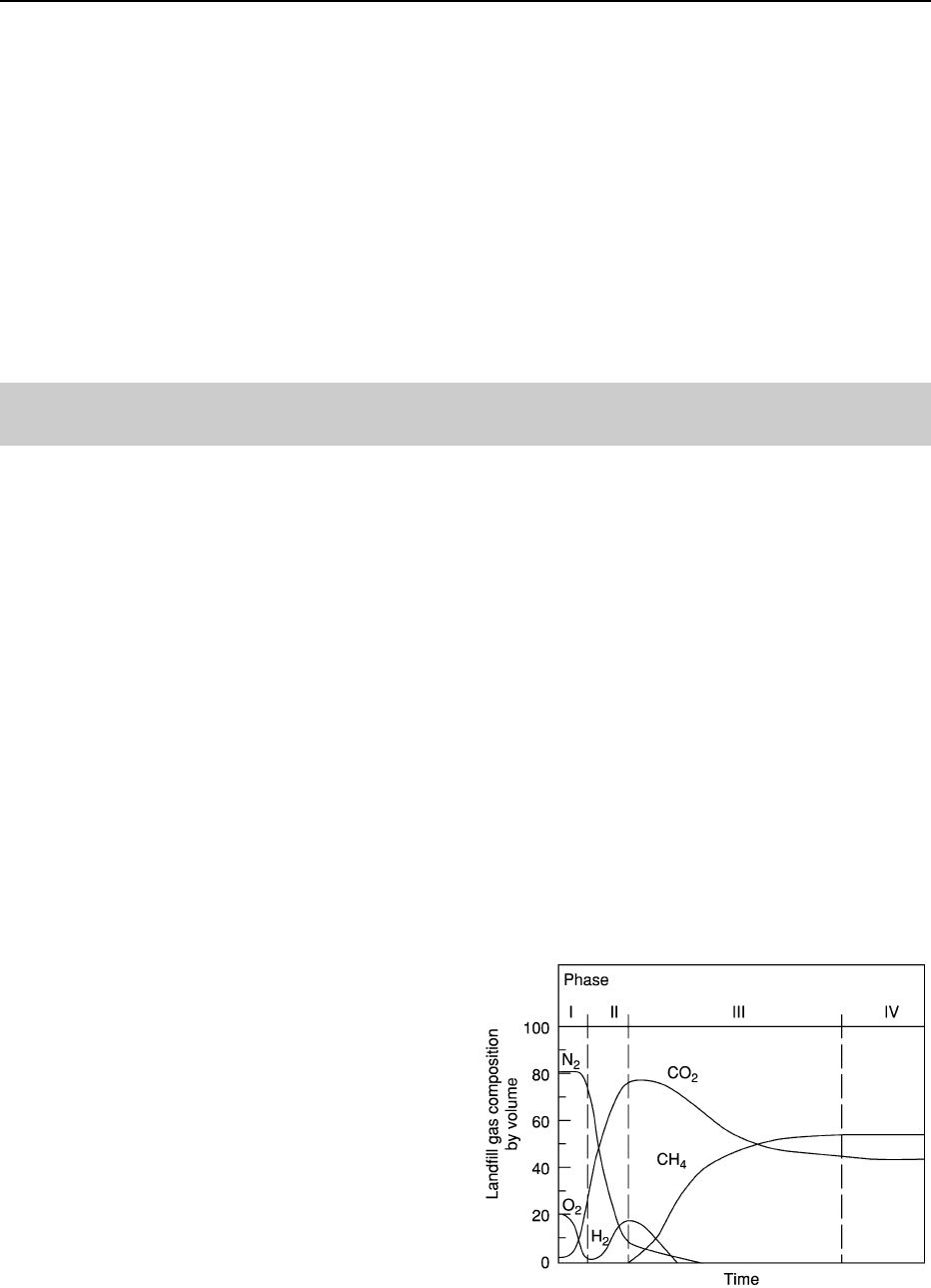
The various phases of gas formation in MSWLFs are
presented in Figure 1. Four phases exist and are desig-
nated as: Phase I, Aerobic; Phase II, Anaerobic Non-
Methanogenic; Phase III, Anaerobic Methanogenic
Unsteady; and Phase IV, Anaerobic Methanogenic
Steady. During Phase II, CO
2
blooms to 50% and
90% by volume. From this peak, CO
2
decreases to
about 30% to 50% during Phase IV. Although CO
2
concentration in water is less than 1 mg l at one atmos-
phere, enrichment to groundwater occurs due to the
concentration of CO
2
in landfill gas. CO
2
is much more
soluble in water than methane [CH
4
], 1700 mgl com-
pared to about 50 mg l; therefore, as the CO
2
gas
Figure 1 Phases of landfill gas formation (after Farquhar and
Rovers (1973)).
14 ENGINEERING GEOLOGY/Ground Water Monitoring at Solid Waste Landfills
pressure increases, CO
2
goes into solution, and forma-
tion of carbonic acid occurs which lowers the pH.
Landfill gas will travel through porous media via
two processes; diffusion in response to a concentra-
tion gradient and convection from a pressure gradi-
ent. Gas will move more readily along paths of least
resistance (zones of high hydraulic conductivity) and
may move outward significant distances if upward
movement is hindered by impervious layers such as
frost, clay, concrete, etc. The depth to which landfill
gas can penetrate is a function of site soil properties
and soil moisture content. The groundwater surface
represents a good lower limit of movement, particu-
larly for methane; however, CO
2
will readily go into
solution.
At MSWLFs with landfill gas migration, a full pH
unit drop is typical in impacted wells as shown in
Figure 2. Wells with no gas impact have pH values
of about six whereas wells with most significant gas
impact have a pH of five or lower. Since a relationship
exists between pH, total alkalinity, and free CO
2
;
having values for two parameters allows the calcula-
tion of the third. For this site, the owner measures pH
and total alkalinity and then determines the free CO
2
concentration. Background CO
2
values are below
50 mg l; however, gas impact has caused the CO
2
values to increase in excess of 400 mg l. Also, as
CO
2
values increase, volatile organic compounds
(VOCs) begin to appear and the percentages of sample
with VOCs increases as CO
2
increases. In contrast,
wells with background concentrations of CO
2
, nearly
75% of all samples do not show VOCs (Figure 3).
From the above discussion, there is a good correl-
ation between elevated CO
2
values and the occur-
rence of VOCs. There are 149 samples with CO
2
concentrations less than 50 mg l and no detections of
VOCs. In contrast, 47% of samples with CO
2
greater
than 50 mg l contained VOCs and the likelihood of a
VOC occurrence increases to 90% with increasing
CO
2
concentration. Using free CO
2
concentrations
as an indicator parameter could reduce the need for
routine analyses of VOCs.
Thermal Surveys
The technical approach for using thermal surveying is
based upon the fact that, in the absence of local influ-
ences, the Earth’s temperature increases about 0.2 to
1.2
C with every 100 feet of depth below the ground
surface. This temperature increase is due to conduct-
ive heat flow; heat moving through a medium such as
Figure 2 pH and CO
2
relationship in groundwater.
Figure 3 VOC and CO
2
relationship.
ENGINEERING GEOLOGY/Ground Water Monitoring at Solid Waste Landfills 15

soil, rock, or groundwater as a result of temperature
differences between the inner Earth and ground sur-
face. A simple example of heat conduction is heat
transferred through a knife held over an open flame;
the handle will become hot to the touch as heat moves
from the knife tip to the handle. At shallow depths,
temperature is also affected by the diurnal, or day–
night cycle, and seasonal, or summer–winter cycle.
Diurnal influences extend only a few feet below the
ground surface but seasonal influences can reach to
depths of about 50 feet.
Heat in the Earth may also move due to advection.
Gas or water can convey heat through porous media
and thus create temperature differentials that may
reflect subsurface media processes. A highly perme-
able gravel bed will carry away the interior Earth’s
heat more rapidly and therefore show a temperature
anomaly that is lower than surrounding, less perme-
able material. Conversely, an anomaly high will exist
where the groundwater is locally affected by heat
above the normal geothermal gradient. MSWLFs gen-
erate heat as a byproduct of decomposition of wastes;
this is demonstrated by the fact that the optimum
temperature for methane generation is about 35
C
(95
F). Once heated, water temperature will change
slowly since it has a high specific heat capacity com-
pared to most natural materials and is therefore a
potentially useful tracer. In addition, increased tem-
perature of water will alter the density and viscosity
such that groundwater at 40
C will travel twice as
fast as water at 5
C. Researchers have used tempera-
ture to trace thermal anomalies as much as five miles
from the source. Traditional application of thermal
surveys include location of groundwater supplies,
identification of geothermal areas, and delineation
of groundwater seepage around dams.
Precisely calibrated thermistors measure electrical
resistance which varies proportionally with tempera-
ture. Thermistor probes are set at depths of about 10
feet to eliminate diurnal effects. Equilibrium requires
about twenty-four hours; readings are taken with a
resistance bridge and values converted to tempera-
tures using calibration tables prepared for each
sensor.
Analyses of dD and d
18
O help identify the probable
source of groundwater. If the isotopic composition
plots close to the meteoric water line in a position
similar to that of present-day precipitation for a par-
ticular geographic region, the groundwater is almost
certainly meteoric.
For the southern California area near a landfill
test site with elevated chlorides, the expected dD and
d
18
O values typically fall in the range of 50% and
7.5%, respectively. Due to shifts in climatic patterns
during the Tertiary, the time period associated with
the bedrock at the test site, precipitation from the
Tertiary differed isotopically from the isotopic
composition of present-day precipitation. This com-
positional difference varies based upon the speci-
fic stratigraphic horizon within the Tertiary. The
significance of the isotopic differences is discussed
below.
D/H and
18
O in Landfill Leachates
It has been observed that significant deuterium en-
richment in landfill leachates are due in part to the
anaerobic decomposition of organic wastes within
landfills. In addition, it was noted that increased dD
and d
18
O in groundwater were contaminated by an
adjacent landfill. Leachates from landfills in Illinois
have dD values enriched about 30% to 60% relative
to dD of local precipitation.
A significant portion of the hydrogen in landfill
methane comes from the landfill leachate where mi-
crobes preferentially use the lighter hydrogen isotope,
thereby enriching the leachate with deuterium. As the
landfill ages and more methane is generated, more
enrichment of deuterium occurs. Thus deuterium
enrichment makes deuterium a very useful tracer for
detecting groundwater impact from landfills.
13
C in Landfills
The major components of landfill gas, methane, and
carbon dioxide (CH
4
and CO
2
), will show unique
isotopic signatures compared to the surrounding en-
vironment. Methanogenesis will cause the CO
2
por-
tion of the landfill gas to become enriched relative to
d
13
C; whereas the CH
4
portion will become depleted
relative to d
13
C. d
13
C values of around þ 20% for
CO
2
and 50% for CH
4
have been reported. Values
for d
13
C will increase as the landfill ages since the
microbes will prefer to use the isotopically light
carbon to produce CH
4
, thereby enriching the CO
2
at the expense of the CH
4
.
Because CO
2
is much more soluble in water
than CH
4
(around 1700 mg l compared to 50 mg l),
landfill leachates will also become enriched with
d
13
C due to increased alkalinity. Using the isotopes
of hydrogen and carbon, researchers have been able
to differentiate various sources for CH
4
.
Environmental Isotopic Analyses
General Principles
Isotopes of specific elements, such as hydrogen,
carbon, and oxygen, have the same number of
protons but different number of neutrons in the
16 ENGINEERING GEOLOGY/Ground Water Monitoring at Solid Waste Landfills

nucleus. This gives a different atomic weight for a
specific element, even though the element maintains
the same atomic number. As an example, hydrogen
occurs as 1H with an atomic weight of 1 or as 2H
(deuterium) or 3H (tritium) with atomic weights of
2 and 3, respectively. Stable isotopes do not undergo
any natural radioactive decay and provide an under-
standing to the source of water or a process affecting
water after release from the atmosphere. Any process
that causes different isotopic ratios in different media
is the result of isotopic fractionation. The most im-
portant process is vapour-liquid fractionation caused
by evaporation and condensation. For instance,
18
O/
16
O in rainwater is different from ocean water,
which is different from oil brines.
For convenience, the d (delta) notation is used to
describe isotope ratios, which is defined as:
d ½sample¼ðR½sampleR½standardÞ=
R½standard1000
where dX represents the relative difference in parts
per thousand (called per mil (%)) between the isotope
ratio (R) in a sample and the ratio in some specified
standard. For d
18
O, the reference standard is SMOW,
Standard Mean Ocean Water; d
13
C uses the PDB
scale, a belemnite from the Pee Dee Formation of
South Carolina; and d
34
S uses the Canyon Diablo
troilite as the reference standard. Stable isotope
values associated with landfill leachates and gases
demonstrate pronounced signatures that are separate
from the surrounding environment.
18
O/
16
O and D/H in Groundwater
The isotopic composition of seawater, is by defin-
ition, zero per mil for both d
18
OanddD. Upon evap-
oration from seawater, the water vapour has an
isotopic concentration of about 80% for dD and
9% for d
18
O. Fractionation processes affect the
isotopes such that rain becomes progressively lighter
in both d Dandd
18
O, as it moves farther from the
ocean source. Data from modern rainfall plots on a
straight line defined as:
dD ¼ 8d
18
O þ 10 ½2
It has been suggested that an upper limit of þ18% þ/
2% exists for d
13
C in landfills due to eventual
steady state conditions that develop between CO
2
input and CH
4
production.
13
C in Oilfield Water
Data regarding d
13
C in oilfield water are not abun-
dant; however, study of d
13
C values for Miocene
petroleum source rocks in California showed high
d
13
C values, greater than þ5% PDB. d
13
C studies
conducted on Miocene rocks in California showed
d
13
C values typically above þ5 and as high as
þ27.8% PDB. Thus, the very high d
13
C values were
the result of degradation of organic acid anions by
sulphate-reducing bacteria. Decarboxylation of short-
chain aliphatic acid anions, principally acetate, is a
probable major source for CO
2
in the oilfield waters.
Isotopic Data Interpretation
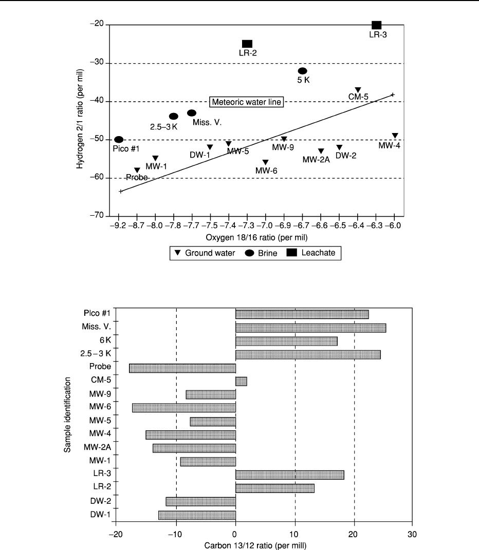
Isotopic data from the California landfill site have
been plotted in various combinations in Figures 4
and 5. Figure 4 depicts d
18
O ratio versus dD ratio
and shows the meteoric water line for rainfall in the
southern California area. If data points plot off this
line, this would indicate that the water (fluid) tested
had been formed in an environment significantly dif-
ferent and unique with respect to normal precipita-
tion. Site groundwater samples tend to plot on or
below the meteoric water line, showing that they are
strongly related to modern precipitation. The brine
samples plot well above the line, indicating a different
source or time period for this water. The leachate
samples are far removed from either brine or ground-
water, showing a totally different and distinct process
of formation. This plot clearly shows that leachate,
groundwater, and brine have distinct isotopic signa-
tures. MW-1, the highest chloride well, and the
‘probe’, (completed in highly fractured bedrock) are
strongly shifted toward the Pico #1 brine sample.
There is a strong probability based on this plot, that
there is some mixing between the oilfield brine being
produced from the Pico #1 (1500 foot zone) and the
water samples obtained from MW-1 and the probe.
Absolutely no mixing of groundwater and leachate
are indicated based on this plot.
Figure 5 is a simple plot that illustrates the wide
variance in carbon isotopic analysis of samples from
groundwater, brine, and leachate sources. The dis-
solved inorganic carbon 13/12 ratios have distinct
and definitive isotopic signatures. This indicates
that the carbon isotopes are extremely useful in delin-
eating any mixing between brine, leachate, and
groundwater. Based upon the simple comparison of
carbon isotopes, there is no relationship between the
groundwater samples and landfill leachate.
Passive In Situ Sampling
Much research and discussion have occurred in recent
years regarding appropriate groundwater sampling
practices.
It has been shown that variable speed centrifugal
pumps reduce purge time, aid in slug and pump tests,
ENGINEERING GEOLOGY/Ground Water Monitoring at Solid Waste Landfills 17
and consistently provide low turbidity. Recent studies
suggest that dissolved oxygen (DO) and Redox, key
field parameters for groundwater sampling, are the
last field parameters to stabilise. Unfortunately, these
parameters are infrequently measured, even though
DO and Redox play an important role in geochemical
equilibrium of trace constituents such as heavy metals.
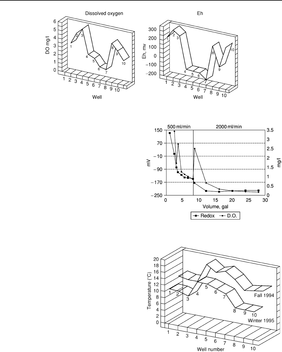
Figure 6 shows upgradient and downgradient DO
and Redox data from a MSWLF in New England
with a defined leachate plume. Due to the anaerobic
nature of leachate, impacted downgradient wells
are depleted of DO and show a strongly reduced
condition. Preliminary findings suggest that purging
a nominal one well volume is necessary to establish
equilibrium of DO and Redox and an average is two
well volumes. In addition, atmospheric conditions
Figure 4
18
O vs. D for brine, leachate, and groundwater for Californian landfill site.
Figure 5 Carbon 13/12 ratios for brine, leachate, and groundwater for Californian landfill site.
18 ENGINEERING GEOLOGY/Ground Water Monitoring at Solid Waste Landfills
apparently influence DO and Redox in a standing
column of well water to depths of 30 feet.
Low-flow purging that removes a minimal volume
of water may not fully remove this atmospheric arti-
fact. Figure 7 shows readings for DO and Redox,
demonstrating an apparent ‘stabilization’ of the two
parameters occurring at low-flow purging. Based
upon USEPA guidelines for sampling, one would con-
clude that representative formation water is present
in the well. However, increasing the flow rate shows a
dramatic decrease in Redox of about 60%; a better
representation of true formation water. This has sig-
nificance for parameters sensitive to reducing condi-
tions such as arsenic. Low-flow purging may have
benefits for sites with known contamination, but for
routine detection monitoring, may have limitations.
In situ passive sampling may have the benefit of
eliminating purging while measuring key parameters
specific to MSWLFs. In situ passive sampling can also
provide continuous monitoring rather than semi-
annual sampling. The owner can set the sampling
intervals to weekly, daily, hourly, or by the minute.
Maintenance is low, with only periodic recalibrations
and battery replacement. Such in situ passive sampling
devices can fit into 2 inch wells and monitor as many
as eight parameters. For MSWLFs, key parameters
would include: water level, temperature, pH, Specific
Conductance, DO, Redox, chloride, ammonium, and
CO
2
. As stated previously, landfill gas impact is char-
acterised by increased CO
2
and depressed pH. Con-
versely, leachate impact is characterized by increases
in temperature, Specific Conductance, chloride, and
ammonium, while DO and Redox will show dramatic
decreases.
By obtaining data on a daily or weekly basis, short-
term temporal or long-term seasonal changes can
be noted and filtered from the data. For example,
Figure 8 shows seasonal temperature data for the
New England MSWLF.
Note that seasonal fluctuations occur for tempera-
ture; however, the most impacted wells the GHR-11,
maintains their high temperature anomaly from
Figure 6 Reduction of DO and Eh in groundwater from leachate impact.
Figure 7 Changes in Eh and DO due to pumping rates in well
MW-1-3D.
Figure 8 Seasonal temperature anomalies from leachate
impact.
ENGINEERING GEOLOGY/Ground Water Monitoring at Solid Waste Landfills 19

early autumn to winter. By utilising in situ passive
samplers, owners and regulatory agencies could real-
ize several key benefits:
.
Parameters Unique to MSWLFs – The Subtitle
D parameter list has inherent problems. Firstly,
most of the heavy metals are not critical to
MSWLFs; secondly, some are soluble under oxidis-
ing conditions and/or low pH, a situation not per-
tinent due to the strongly reducing and buffering
nature of MSWLF leachate; thirdly, the list impli-
citly assumes leachate impact only and does not
address impact from landfill gas. Alternative par-
ameters, such as those presented in this article, not
only serve as better indications of groundwater
impact but also will better delineate the means of
impact, leachate, or landfill gas.
.
Continuous Monitoring of Ground Water – Rather
than quarterly or semi-annual monitoring, in situ
passive sampling can provide much more data that
depicts temporal, seasonal, or long-term trends in
groundwater quality.
.
Reduced Frequency of Sampling – Owners could
reduce sampling frequency by using the data from
in situ monitoring to determine if and when a
sample should be taken. By establishing confidence
intervals or other statistical criteria, owners would
take samples only when exceedences of such
criteria occurred.
.
Cost Control – Reduction of groundwater monitor-
ing costs, particularly post-closure accruals, would
assist owners with small buckets, such as munici-
palities.
.
Error Reduction – Data is simply downloaded
from a datalogger to a laptop computer, thereby
reducing a significant source of error, manual
transcription.
.
Better Public Relationship – Continuous monitor-
ing could reduce public concern and increase
confidence that a MSWLF is operated properly.
Conclusion
This article presents options to traditional ground-
water monitoring at MSWLFs. By incorporating
these options, owners can better delineate leachate
versus gas impact; fingerprint definitive sources, and
generate more and higher-quality groundwater data
specific to MSWLFs. In Situ passive sampling may
provide several benefits that include sampling
frequency reduction, understanding of temporal
trends, cost control, transcription error reduction,
and better public confidence.
See Also
Engineering Geology: Natural and Anthropogenic Geo-
hazards; Liquefaction; Made Ground. Quarrying.
Further Reading
Baedecker MJ and Back W (1979) Hydrogeological Pro-
cesses and Chemical Reactions at a Landfill. Ground
Water 17: 429–437.
Barcelona Michael, et al. (1990) Contamination of Ground
Water: Prevention, Assessment, Restoration. Park Ridge,
New Jersey: Noyes Data Corporation.
Beluche R (1968) Degradation of Solid Substrate in a Sani-
tary landfill. Ph.D. Thesis, University of Southern Cali-
fornia, Los Angeles, California.
Birman J (1990) Handbook of Ground Water Development
by Roscoe Moss Company. New York: John Wiley and
Sons.
Carothers WW and Kharaka YK (1980) Stable Carbon
Isotopes Of HCO
3
– in Oil-field Waters – Implications
for the Origin of CO
2
. Geochimica et Cosmochimica
Acta 44: 323–332.
Coleman DD, et al. (1993) Identification of Landfill
Methane using Carbon and Hydrogen Isotope Analysis.
Proceedings of 16th International Madison Waste Con-
ference, pp. 303–314. University of Wisconsin-Madison.
Drever JI (1982) The Geochemistry of Natural Waters.
Englewood Cliffs: NJ Prentice-Hall.
Farquhar GJ and Rovers FA (1973) Gas Production During
Refuse Decomposition, Water, Air and Soil Pollution.
Vol. 2.
Matthess FPG and Brown RM (1976) Deuterium and
oxygen-18 as indicators of Leachwater Movement
from a Sanitary Landfill. In: Interpretation of Environ-
mental Isotope and Hydrochemical Data in Ground-
water Hydrology. Vienna International Atomic Energy
Agency.
Games LM and Hayes JM (1977) Carbon Isotopic Study of
the Fate of Landfill Leachate in Groundwater. Journal of
Water Pollution Control Federation 49: 668–677.
Hackley KC, Liu CL, and Coleman DD (1996) Environ-
mental Isotope Characteristics of Landfill Leachates and
Gases. Ground Water 34(5): 827–834.
Liu, et al. (1992) Application of Environmental Isotopes to
Characterize Landfill Gases and Leachate. Geological
Society of America Abstracts with Programs, Cincinnati,
Ohio, p A35.
Ludwig H (1967) Final report: In Situ Investigation of
Gases Produced from Decomposing Refuse. California
State Water Quality Control Board.
Murata KJ, Friedman I, and Madsen BM (1969) Isotopic
Composition of Diagenic Carbonates in marine Miocene
Formations of California and Oregon. US Geology
Survey Professional Paper 614–B.
Oneacre JW (1992) Solid waste – Principles and Practice in
the United States. International Conference on Environ-
mental Protection and Control Technology, Enserach,
Kuala Lumpur, Malaysia, pp. 661–674.
20 ENGINEERING GEOLOGY/Ground Water Monitoring at Solid Waste Landfills