Elsevier Encyclopedia of Geology - vol I A-E
Подождите немного. Документ загружается.

Engineering Geology
Major construction works depend upon sound site
investigation, which documents the underlying geo-
logical setting and the strengths and behaviours of the
rocks and engineering sols and recognizes hazardous
ground conditions. In the UK alone, over 30% of all
major civil engineering projects are delayed owing to
poor ground conditions. It is essential to carry out
thorough site investigations, using a range of geo-
logical techniques, including mapping and geophys-
ical surveys, as well as committing significant time to
material testing. Consideration of climate is a major
issue, as in Hong Kong, where the failure of tower
blocks has been attributed to the failure of thick trop-
ical soils overlying crystalline basement, coupled with
high rainfall (see Engineering Geology: Overview).
Geology of Waste Management
The urban machine creates an immense amount of
waste, which may be defined as any substance that
constitutes a scrap material, effluent, or unwanted
surplus or any substance or article that requires dis-
posal because it is worn-out or contaminated in some
way. Although there is increasing emphasis on waste
minimization and recycling, it is accepted that there
will always be waste and that a strategy for its
disposal will be required.
Wastes can conveniently be divided on the basis of
whether they are managed (i.e. there is a management
strategy in place to deal with their disposal that is in
line with current practice and legislation) or unman-
aged (i.e. there is no management strategy). Strategies
for dealing with wastes have been based largely on
two concepts: dilute and disperse, or concentrate and
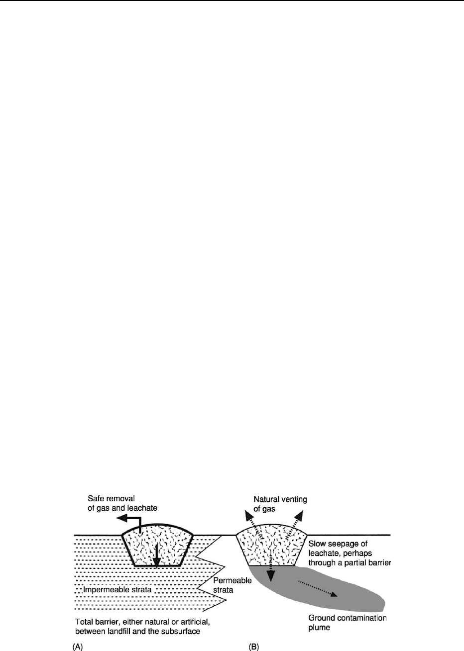
contain (Figure 5). The failure of these strategies
ultimately leads to pollution, which is a by-product
of inadequate waste-management strategies.
The dilute-and-disperse strategy is now largely dis-
credited, because it relies on the potential of a given
environmental setting to dilute the waste materials
and then to disperse them. This has been, and con-
tinues to be, an issue for the dispersal of effluents in
the sea and of gases in the atmosphere, as these natural
systems are becoming choked with inadequately dis-
persed wastes. Concentrate and contain is now seen
as the most viable option, with wastes being concen-
trated, compacted, or shredded where possible, before
being placed in a safe totally enclosed (or ‘sanitary’)
facility. At one level this entails the adequate prepar-
ation of a landfill site; at another, the containment of
radioactive materials in an appropriate repository in
perpetuity.
Contaminated Land
Contaminated land is any area that has been contam-
inated by its past industrial use or by the disposal of
wastes. Contamination is therefore an inevitable eff-
ect of industrialization, and of waste disposal, as it
involves the introduction of materials not naturally
present at a given location. Contaminated land is a big
issue in developed nations, with the decline in heavy
industry and the targeting of former sites of industry
as valuable real estate in inner-city locations. Increas-
ingly, there is a need for adequate assessment of a site –
assessing the type and level of contamination – before
developing a clean-up strategy.
Sanitary Landfill
Employing the principle of concentrate and contain,
sanitary landfills (Figure 5) ensure that appropriate
voids are chosen for landfilling, appropriate contain-
ment strategies are employed in developing the land-
fill (using liners, separating the void into cells divided
by bunds, and capping the site securely), the void is
filled in an economical and organized manner, and
Figure 5 Landfill options: (A) total containment, and (B) slow dispersal. (Reproduced with permission from Bennett MR and Doyle
P (1997) Environmental Geology: Geology and the Human Environment. Chichester: John Wiley.)
30 ENVIRONMENTAL GEOLOGY
the by-products of the decay of putrescible wastes (i.e.
landfill gas and leachates) are removed safely. The
decomposition of wastes by bacteria takes place in
three phases: first, aerobic bacteria break down the
large organic molecules; second, anaerobic bacteria
create simple compounds, such as hydrogen, ammo-
nia, carbon dioxide, and organic acids; and, finally,
the methane-rich landfill gas is created. In practice,
this means that in the early years of a landfill the
amount of gas produced is relatively small, rising
to a maximum in around 20 years. Uncontrolled mi-
gration of this gas can be lethal, as in some cases the
results have been explosive, with gases migrating
through suitable geological pathways, as happened
in 1986 at Loscoe in northern England. Leachates
are dealt with by ponding and removal, in most
cases, and then treated.
Deep Repositories for Nuclear Wastes
The disposal of nuclear radioactive wastes is a diffi-
cult problem, given the ‘geological’ time-scales of the
half-lives of the isotopes of uranium used in the
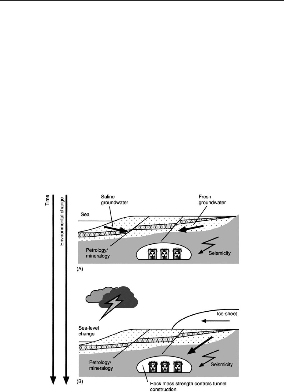
nuclear-power industry. One option is to concentrate
wastes in a secure surface repository, which can be
monitored to ensure that the multiple walls of the
containment are secure. This obviously requires a
long-term commitment. Over the last few decades,
other options have been considered, including using
a uniform densely crystalline deep-crustal rock body
as a natural repository, which could be sealed in per-
petuity (Figure 6). Lithologies considered have in-
cluded fine-grained tuffs, basalts, and evaporates,
and detailed investigations in the UK and the USA
of the feasibility of sites in Cumbria and Texas, re-
spectively, have been carried out. However, technical
difficulties and political issues have stalled these
geological solutions.
Geology of Natural Hazards
Natural hazards occur on a regular basis, cause dis-
ruption and destruction, and annually lead to large
losses of life under tragic circumstances (see Engineer-
ing Geology: Natural and Anthropogenic Geohazards).
Geological hazards include high-magnitude low-
frequency events (earthquakes, volcanoes, and tsu-
namis) and low-magnitude high-frequency events
Figure 6 Deep-repository option for nuclear wastes, illustrating (A) the current geology, and (B) the geology at some point in
the future with the influx of fresh glacial meltwaters (arrow). (Reproduced with permission from Bennett MR and Doyle P (1997)
Environmental Geology: Geology and the Human Environment. Chichester: John Wiley.)
ENVIRONMENTAL GEOLOGY 31
(such as soil, fluvial, and coastal erosion). Dealing with
both types of event severely tests the local civil-defence
infrastructures, and, with the frequency of disasters
apparently on the increase – with attendant casualties
and economic costs – planning for disaster manage-
ment is a major preoccupation of local authorities.
There are three broad hazard types: atmospheric
hazards, caused by tropical storms, hurricanes, and
droughts; exogenic hazards, such as flooding, coastal
erosion, and mass movement; and endogenic hazards,
resulting from internal Earth processes, such as vol-
canoes and earthquakes. In many cases there can be
considerable overlap between these events, as one can
trigger another. In profiling natural hazards, it is im-
portant to gather data on the magnitude and fre-
quency (including temporal spacing) of the events,
the duration and speed of onset of a typical event,
and the extent and dispersion of the effects. These
issues have to be taken into account in civil-defence
planning strategies, which will identify the risk to life,
property, and the economy.
Risk assessment is an important task and will in
many cases involve a predictive element, although
prediction of earthquakes and volcanic eruptions is
a tricky business, without a simple solution. Hazard
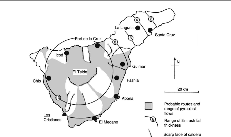
mapping is a significant technique and had been used
to good effect in identifying patterns of eruption in
populated volcanic regions (Figure 7). This, together
with a numerical assessment of the vulnerability of a
given settlement, are important tools in the armoury
of an environmental geologist.
See Also
Building Stone. Clays, Economic Uses. Engineering
Geology: Overview; Natural and Anthropogenic Geoha-
zards. Geological Conservation. Geological Engineer-
ing. Quarrying. Urban Geology.
Further Reading
Bailleul TA (1987) Disposal of high-level nuclear waste in
America. Bulletin of the Association of Engineering
Geologists 24: 207–216.
Bell FG (1992) Salt mining and associated subsidence in
mid-Cheshire, England, and its influence on planning.
Bulletin of the Association of Engineering Geologists
29: 371–386.
Bell FG (1993) Engineering Geology. Oxford: Blackwell.
Bell FG (1996) Dereliction: colliery spoil heaps and
their rehabilitation. Environmental and Engineering
Geoscience 2: 85–96.
Bell FG, Duane MJ, Bell AW, and Hytiris N (1996)
Contaminated land: the British position and some case
histories. Environmental and Engineering Geoscience 2:
355–368.
Bennett MR and Doyle P (1997) Environmental Geology:
Geology and the Human Environment. Chichester: John
Wiley.
Figure 7 Volcanic hazard map of Tenerife, Canary Islands.
32 ENVIRONMENTAL GEOLOGY

Booth B (1979) Assessing volcanic risk. Journal of the
Geological Society of London 136: 331–340.
Bryant EA (1991) Natural Hazards. Cambridge:
Cambridge University Press.
Culshaw MG, Bell FG, Cripps JC, and O’Hara M (eds.)
(1987) Planning and Engineering Geology. London:
Geological Society.
Doyle P, Barton P, Rosenbaum MR, Vandewalle J, and
Jacobs K (2002) Geoenvironmental implications of the
underground war in Flanders, 1914–1918. Environmen-
tal Geology 43: 57–71.
Fookes PG and Poole AB (1981) Some preliminary consid-
erations on the selection and durability of rock and con-
crete materials for breakwaters and coastal protection
works. Quarterly Journal of Engineering Geology 14:
97–128.
Gray M (2004) Geodiversity: valuing and conserving abiotic
nature. Chichester: John Wiley.
Gray RE and Bruhn RW (1984) Coal mine subsidence: east-
ern United States. Geological Society of America Reviews
in Engineering Geology 6: 123–149.
Joseph JB (2004) Perception or reality – waste, landfill and
the environment. Geology Today 20: 107–112.
Lumsden GI (ed.) (1992) Geology and the Environ-
ment in Western Europe. Oxford: Oxford University
Press.
McFeat-Smith I, Workman DR, Burnett AD, and Chau EPY
(1989) Geology of Hong Kong. Bulletin of the Associ-
ation of Engineering Geologists 26: 23–107.
Prentice JE (1990) Geology of Construction Materials.
London: Chapman & Hall.
Price M (1985) Introducing Groundwater. London: Allen
& Unwin.
Smith K (1996) Environmental Hazards: Assessing Risk
and Reducing Disaster, 2nd edn. London: Routledge.
Thomas RG (1989) Geology of Rome, Italy. Bulletin
of the Association of Engineering Geologists 26:
415–476.
Waltham AC (1994) Foundations of Engineering Geology.
Glasgow: Blackie.
Williams GM and Aitkenhead N (1991) Lessons from
Loscoe: the uncontrolled migration of landfill gas.
Quarterly Journal of Engineering Geology 24: 191–207.
Woodcock NH (1994) Geology and Environment in Britain
and Ireland. London: UCL Press.
EROSION
See SEDIMENTARY PROCESSES: Erosional Sedimentary Structures; Aeolian Processes; Fluxes and
Budgets
ENVIRONMENTAL GEOLOGY 33

a0005 EUROPE
Contents
East European Craton
Timanides of Northern Russia
Caledonides of Britain and Ireland
Scandinavian Caledonides (with Greenland)
Variscan Orogeny
The Urals
Permian Basins
Permian to Recent Evolution
The Alps
Mediterranean Tectonics
Holocene
East European Craton
S V Bogdanova and R Gorbatschev, Lund
University, Lund, Sweden
R G Garetsky, Institute of Geological Sciences, Minsk,
Belarus
ß 2005, Elsevier Ltd. All Rights Reserved.
Introduction
The East European Craton is the coherent mass of
Precambrian continental crust in the north-eastern
half of Europe. Across a suture zone between the
North Sea and the Black Sea, that crust meets the
younger, thinner, warmer, and more mobile crust of
western and southern Europe.
The overall area of the East European Craton is
more than 6.7 million km
2
, including the shelf seas.
Within the East European Craton, Precambrian
crystalline crust is exposed in the Baltic (also Fennos-
candian) and Ukrainian Shields as well as in minor
areas in Belarus and the Voronezh Massif of south-
western Russia. Elsewhere, the craton is covered by
the Late Proterozoic and Phanerozoic sedimentary
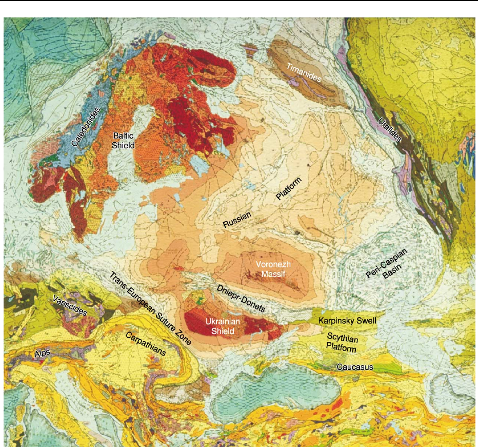
deposits of the Russian Platform (Figure 1).
The present state of the East European Craton is
largely controlled by structures dating back to the
time of its formation by the successive collision of
three large, once independent, crustal segments –
Fennoscandia, Sarmatia, and Volgo-Uralia – in the
Palaeoproterozoic, ca. 2.1–1.7 Ga ago. This view
was first proposed in 1993. Until then, the East
European Craton was regarded as a rather uniform
region of numerous minor ‘blocks’ of Archaean crust
set in a matrix of Proterozoic folded belts.
Margins and Borders
Most of the margins of the East European Craton are
characterized by the presence of younger mobile belts
(Figure 1). In the north-west, the Scandinavian Cale-
donides (see Europe: Scandinavian Caledonides (with
Greenland)) form a ca. 1800 km long strongly eroded,
but still up to 15-km thick, pile of large thrust sheets
built up of Early Palaeozoic and Precambrian rocks.
These nappes derive from source areas far to the
present west and were thrust atop the crystalline base-
ment around 450–400 Ma ago. Autochthonous base-
ment fabrics are still perceptible throughout the
Caledonides, while geophysical and palaeogeographi-
cal data indicate that the Pre-Caledonian margin of
the East European Craton may be as much as 400 km
off the Atlantic coast of Scandinavia.
Along the north-eastern margin of the East
European Craton, the Timanide Belt extends between
the Urals and northernmost Norway (see Europe:
Timanides of Northern Russia). It features initial
sedimentation along a passive continental margin,
followed by compression, metamorphism, and
igneous activity due to subduction and collision
650–600 Ma ago.
The eastern limit of the East European Craton is
the Late Palaeozoic Uralide Orogen, which repre-
sents the zone where ancient Europe collided with
Asian terranes 350–300 Ma ago (see Europe: The
Urals). Farther south-west, the margin of the East
34 EUROPE/East European Craton
European Craton was developed in the Neoprotero-
zoic and Early Cambrian due to collision between
the Craton and part of Gondwana. That margin was
subsequently complicated by the uplifted south-
eastern continuation of the Devonian Dniepr–Donets
Aulacogen (the Karpinsky Swell in Figure 1).
The southern edge of the East European Craton
is outlined by the Alpine mountain belts of the
Crimea and Caucasus. In that region, the Scythian
Platform marks a slab of East European cratonic
crust involved in the Alpine–Mediterranean orogenic
process.
Figure 1 The East European Craton in its crustal setting between central Europe and western Siberia. The craton area is marked in
reddish-brown colours. The fainter the tint, the thicker the sedimentary cover. The areas of outcrop in the Baltic and Ukrainian Shields
and the Voronezh Massif can be clearly seen. The cover is also thin in Belarus, but only in a minor uplift is the craton actually exposed. It
can also be seen that the basement is more deeply buried in the eastern part of the Russian Platform than in the west. Between the
eastern region and the basin beneath the southern Baltic Sea is the so-called ‘Scythian Rampart’ of the early geologists, which connects
the Baltic and Ukrainian Shields. The cover is thickest in the Peri-Caspian Basin, where the mottled patterns denote salt-dome tectonics.
Among the large rifts and aulacogens characteristic of the East European Craton, the originally Proterozoic but subsequently rejuven-
ated central Russian and Pachelma systems can be clearly recognized. The latter is immediately north-north-east of the Voronezh
Massif. The rift systems to the west of the Urals and in the south-western foreland of the Timanides can also be seen. Prominent in the
south is the Devonian Dniepr–Donets Aulacogen and its inverted eastward continuation (the so-called ‘Karpinsky Swell’) between the
Scythian Platform and the Peri-Caspian Basin and onwards into Asia. This figure is part of the ‘Carte Tectonique de l’Europe et des
Re
´
gions Avoicinantes,’ scale 1 to 10 min. IUGS Commission for the Geological Map of the World, 1975 (by courtesy of the CGMW.)
EUROPE/East European Craton 35

In the south-west, the Trans-European Suture Zone
is the limit of the East European Craton. Across
that boundary, the Craton abuts terranes successively
formed during the Caledonian, Variscan, and Alpine–
Mediterranean orogenies. Along the central course of
the Trans-European Suture Zone, palaeontological
data indicate that some terranes in Poland repre-
sent detached slices of the Craton. In northern
Germany, a wedge of East European cratonic crust
has been traced seismically far to the south-west of
the Trans-European Suture Zone.
Crustal Thickness and Magnetic and
Gravity Fields
The crust of the East European Craton is mostly
around 35 km to somewhat more than 40 km
thick. Moho depths of up to 50 km occur particularly
in a wide central area near Moscow, in the south-
west, and in the Ukrainian and Baltic Shields.
Local maxima may even exceed 60 km. Under some
of the Archaean parts of the East European Craton,
cratonic roots in the lithospheric mantle reach down
to 200–250 km.
The most pronounced Moho uplift, to a level of
around 30 km, is associated with the northern part of
the Peri-Caspian Basin, where a thick Proterozoic to
Phanerozoic cover is also present. In consequence, the
thickness of the Precambrian crystalline crust is only
10–15 km in that region.
At the borders of the East European Craton, Moho
depths increase along the Uralides and the Caucasus
collisional belts as well as in the central and southern
parts of the Trans-European Suture Zone. Further
north, continental crust thins markedly towards the
North Atlantic Ocean.
In detail, steep gradients of Moho depth commonly
follow one-time collisional and accretionary plate
and terrane boundaries and, in general, the boundar-
ies between Archaean and Proterozoic crust. How-
ever, in places, the original continental crust has been
thickened by later mafic underplating or thinned by
extension and magmatism.
The East European Craton differs from the neigh-
bouring parts of Europe and western Siberia in fea-
turing numerous belts of strong magnetic anomalies.
These outline the boundaries of the different crustal
units as well as later rifts and some major belts of
granitic and high-grade metamorphic rocks (Figure 2).
The patterns of the gravity field are similar, but
strongly negative anomalies occur only along the
Scandinavian Caledonides and just outside the limits
of the craton along the Carpathian, Crimean, and
Caucasian Alpine–Mediterranean mountains.
Morphology, Topography, and
Sedimentary Cover
Morphologically, most of the East European Craton
forms a vast low-lying plain. Some small-scale broken
topography exists in the shield areas, particularly in
the recently glaciated Baltic Shield. The largest flats,
in contrast, extend towards the south-east, where the
Peri-Caspian depression is largely below global sea-
level (Figure 1). Pronouncedly mountainous areas
occur only in western and northern Scandinavia,
where the Caledonides and their Precambrian base-
ment were uplifted and topographically rejuvenated
during the opening of the North Atlantic.
The cover of the Russian Platform mostly ranges
between some tens of metres and 2 km in thickness
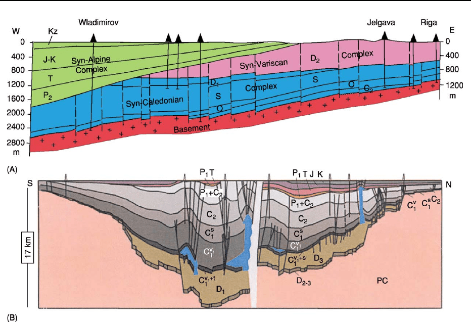
(Figures 1 and 3A). Several rifts and basins, however,
contain sedimentary piles 3–5 km thick, while the
Dniepr–Donets Aulacogen in the Ukraine and south-
western Russia has a fill exceeding 15 km in thickness
(Figure 3B). A general depression of the basement–
cover boundary occurs towards the marginal moun-
tain belts of the Timanides, Uralides, and Caucasus, the
greatest cover thickness of approximately 20 km being
reached in the area to the north of the Caspian Sea.
The covered parts of the East European Craton
comprise several large basins of sedimentation, e.g.
the Moscow, Baltic, and Peri-Caspian basins. These
were largely formed in response to recurrent cycles of
rifting, subsidence, and compression. Maxima of
basin formation and filling occurred during the
Riphean (Meso- to Neoproterozoic), the Early Ven-
dian (terminal Neoproterozoic), the Late Cambian-
Ordovician, the Middle-to-Late Devonian, the
Carboniferous–Permian transition, and the Triassic
(Figures 3–5). Generally, these maxima were related
to orogenies, major plate-tectonic movements, rota-
tions of the East European Craton, and its interaction
with other proto-continents such as Laurentia,
Greenland, and Avalonia.
Large rifts and aulacogens are characteristic elem-
ents of the East European Craton (Figure 6). Many of
the oldest, i.e. of Meso- to Neoproterozoic age, are
associated with the system of Palaeoproterozoic
sutures that arose as a result of the formation of
the craton from several colliding crustal segments.
To this group belong the Pachelma, Volyn-Orsha,
and Central Russian rifts and aulacogens (Figure 6).
Other rifts of that age follow age-province boundar-
ies, while several Neoproterozoic troughs in the Peri-
Urals region were developed on a Mesoproterozoic
passive continental margin. Unlike the Precambrian
rifts, many Phanerozoic rifts, for instance the Dniepr-
Donets Aulacogen, cut sharply across the grain of
the crust.
36 EUROPE/East European Craton
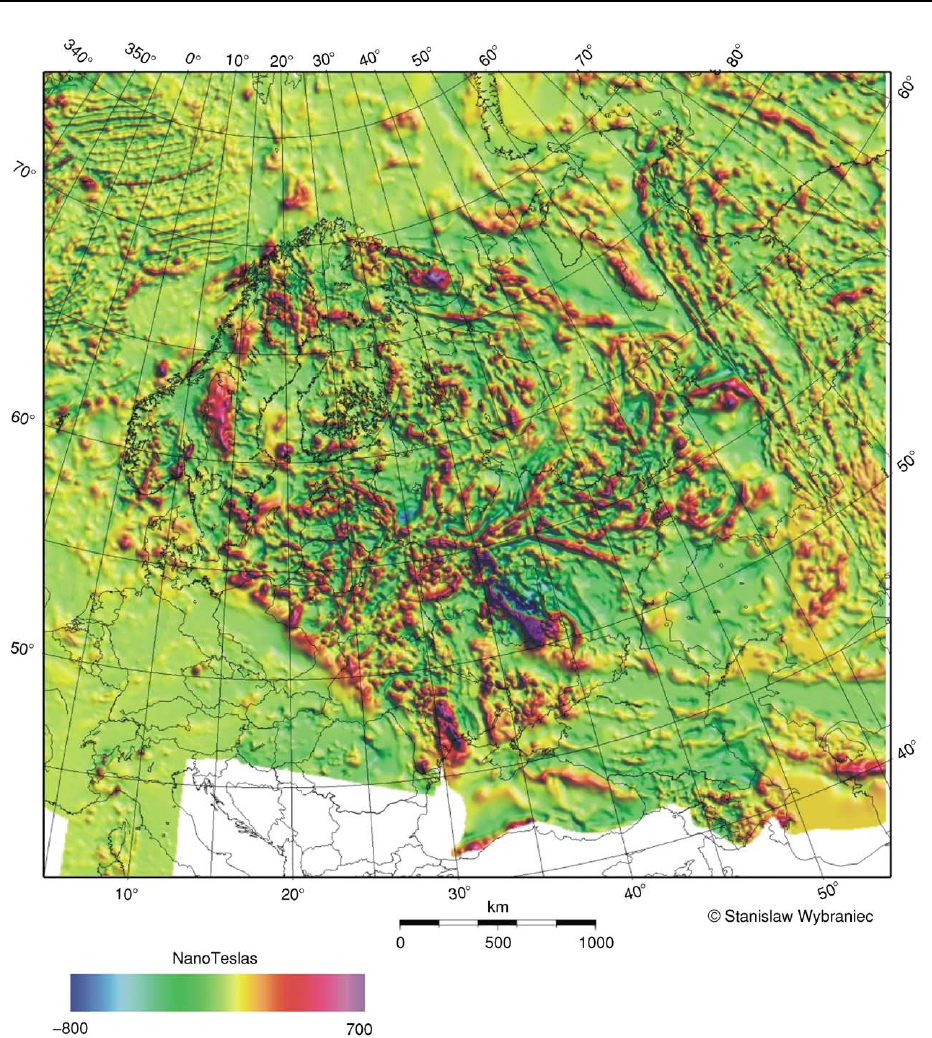
Figure 2 Magnetic anomaly patterns in the East European Craton. In general, these patterns describe very well the tripartite crustal-
segment structure of the East European Craton (cf. Figure 8). In addition, the strongest positive anomalies mark major occurrences of
magnetic iron ores, for example the Kursk magnetic anomaly in the Voronezh Massif and the anomalies indicating the ores of
northernmost Sweden (Kiruna, etc) and the Kriviy Rog ores in the Ukraine. Where sedimentary fillings are very thick in rifts and basins,
ribbon-shaped negative or alternating negative–positive anomaly patterns prevail (e.g. in the Dniepr–Donets and Pachelma Aulaco-
gens and the Peri-Caspian Basin). Moderately positive anomalies are associated with amphibolite to granulite facies metamorphic
belts and some granite provinces, such as the rapakivi massifs and parts of the Trans-Scandinavian Igneous Belt. However, other
rapakivi plutons (Viborg, for instance) have negative anomalies. Similar diversity is also found for the Archaean protocratons. Map by
courtesy of S Wybaniec of the Polish Geological Institute.
EUROPE/East European Craton 37
Rifting in the East European Craton was com-
monly accompanied by within-plate mafic magma-
tism, which, during some periods, e.g. the Devonian,
may have been associated with mantle-plume
upwelling. Among the products are kimberlites (see
Igneous Rocks: Kimberlite) found, for instance, in the
Ukrainian Shield, Voronezh Massif, and Kola Penin-
sula region.
Crustal Segments of the East
European Craton
The Meso- and Neoproterozoic Volyn-Orsha, central
Russia, and Pachelma rifts and aulacogens divide
the East European Craton into three different parts
(Figures 6 and 8). Research during the last 15 years
has demonstrated that these correspond roughly to
three Precambrian crustal segments, each of which
has its own Archaean–Palaeoproterozoic history.
The three segments are Fennoscandia (including
the Baltic-Fennoscandian Shield) in the north-west
and north, Sarmatia (comprising the Ukrainian Shield
and the Voronezh Massif) in the south, and Volgo-
Uralia in the east.
Fennoscandia and Sarmatia both feature Archaean
cores and accreted Palaeoproterozoic juvenile
continental crust, whereas Volgo-Uralia is almost
entirely Archaean but was strongly reworked in the
Palaeoproterozoic.
Fennoscandia
The Fennoscandian crustal segment consists of two
principal parts (Figure 9). In the north-east there is a
large domain of Archaean crust, while the rest of the
segment is made up of Palaeo- and Mesoproterozoic,
mostly juvenile, mantle-derived rocks. These belong
to several successively formed orogenic belts.
The demarcation between the Archaean and Pro-
terozoic regions is fairly sharp, but the edge of the
Archaean has been reworked tectonically and
Figure 3 Sections across the Phanerozoic sedimentary cover of the Russian Platform and adjoining areas. (A) Profile of the eastern
part of the Baltic Sea Depression, showing the disconformities between three different tectonostratigraphic complexes. These
correspond roughly to the three Phanerozoic orogenies that shaped adjoining central Europe and changed the regimes of sedimenta-
tion and erosion within the East European Craton. C, Cambrian; O, Ordovician; S, Silurian; D, Devonian; P, Permian; T, Triassic;
J, Jurassic; K, Cretaceous; Kz, Cenozoic. (B) General seismic section across the Dniepr–Donets Rift Basin. The ends of the section are
approximately 170 km apart, but the middle portion of the profile has been omitted from the diagram. Salt diapirs are shown in blue.
Pc, Precambrian; D, Devonian; C, Carboniferous; P, Permian; T, Triassic; J, Jurassic; K, Cretaceous. Seismic section by courtesy of the
Secretariat of the EUROPROBE Programme.
38 EUROPE/East European Craton
magmatically, and is overlain or overthrusted by
Palaeoproterozoic rock units. Inside the Archaean
domain, however, is the north-west–south-east trend-
ing Late Palaeoproterozoic collisional Lapland–Kola
Orogen, while isotopic data suggest that parts of
the Palaeoproterozoic region in the south-west are
underlain by blocks or wedges of Archaean crust.
The Archaean domain comprises the Karelian Pro-
tocraton, the Belomorian Belt along the White Sea,
several different terranes in the Kola Peninsula, and a
western province extending all the way to the Lofoten
Islands of Norway but partly hidden beneath the
Caledonide allochthon.
The Karelian Protocraton is the largest province of
Archaean crust. It contains a sizable area and several
minor occurrences of igneous rocks older than
3.1 Ga, the oldest zircon ages being about 3.5 Ga.
These rock units are set in terranes dominated by
3.0–2.8 Ga greenstone belts rich in komatiites (see
Igneous Rocks: Komatiite) and juvenile tonalite–
trondhjemite–granodiorite (TTG) granitoids. The
greenstone belts are of several generations and have
been attributed to a number of different geodynamic
settings such as continental rifts, oceanic arcs, and
active continental margins. Remnants of approxi-
mately 2.8 Ga ophiolites are found in the north-
eastern part of the Protocraton. In the literature,
block mosaics as well as large gently dipping crustal
wedge structures are indicated. This suggests
a complex but still largely undeciphered story of
Mesoarchaean continent assemblage. In the Neoarch-
aean, i.e. after 2.8 Ga, volcanism and granitoid mag-
matism continued, producing rocks ranging from
TTG complexes to granites of collisional regimes
and late post-kinematic intrusions.
Similar Neoarchaean developments characterize
the adjacent Kola and Belomorian provinces, but
these lack rocks older than 3.0 Ga. A notable feature
of the Central Kola sub-province is the presence of the
thick but subsequently highly metamorphosed 2.7 Ga
Keivy cover sequence, which is known for its giant
crystals of kyanite, staurolite, and other minerals.
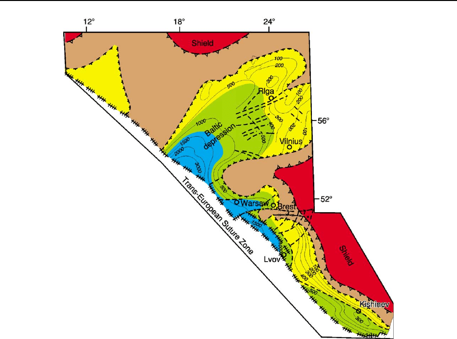
Figure 4 Lithologies of the Cambrian to Silurian rocks along the south-western margin of the East European Craton. The lithofacies
zones are: blue, deep-water pelites; green, lower-shelf calcareous and pelitic rocks; and yellow, shallow-water calcareous rocks. The
brown fields represent areas from which these and similar lithologies have been removed by erosion; red indicates other parts of the
exposed Precambrian crystalline crust. ß Svetlana Bogdanova.
EUROPE/East European Craton 39
