Elsevier Encyclopedia of Geology - vol I A-E
Подождите немного. Документ загружается.

sea-level changes and isostatic uplift or subsidence,
partly modified by tectonic movements, produced
considerable changes in the geography of Europe
during the Holocene. Depending on the geographic
position of the affected area, large relative sea-level
changes (positive or negative ones) have occurred
(Figure 7). These changes are particularly obvious
where large intracontinental basins like the recent
Baltic Sea area were affected.
At the beginning of the Holocene, large parts of the
Baltic Basin were filled with freshwater from the Baltic
Ice Lake which was fed mainly by meltwater from a
large glaciated area in North and north-eastern Europe.
The only important outlet in the O
¨
resound (between
the recent Danish island Sealand and southern Sweden)
was too narrow to serve as a sufficient spillway be-
tween the Baltic Ice Lake and the North Sea. The global
sea-level was about 25 metres lower than in the Baltic
Ice Lake. When the Scandinavian inland ice started
to retreat from southern Sweden, a spillway through
the central Swedish Depression was opened. As a
dramatic process, half of the recent Baltic Sea’s
water volume drained into the Atlantic Ocean via
the Kattegat and North Sea. This drainage took no
longer than a few years and had an enormous impact
along the former shores of the Baltic Ice Lake. Large
areas previously covered by water became dry land,
and southern Scandinavia became directly connected
to central Europe. Saline waters of the Kattegat could
enter the Baltic Basin for a time-span of a few hun-
dred years, a stage of the Baltic Sea’s development
known as the Yoldia Sea, a phase which is dated from
11 570 to 10 700 years BP (Figure 8).
The connection between the Yoldia Sea and the Kat-
tegat through central Sweden was located in a rapidly
uplifting region. Therefore, the connection closed at
about 10 700 years BP and a newly dammed-up fresh-
water lake was formed within the Baltic Basin. It
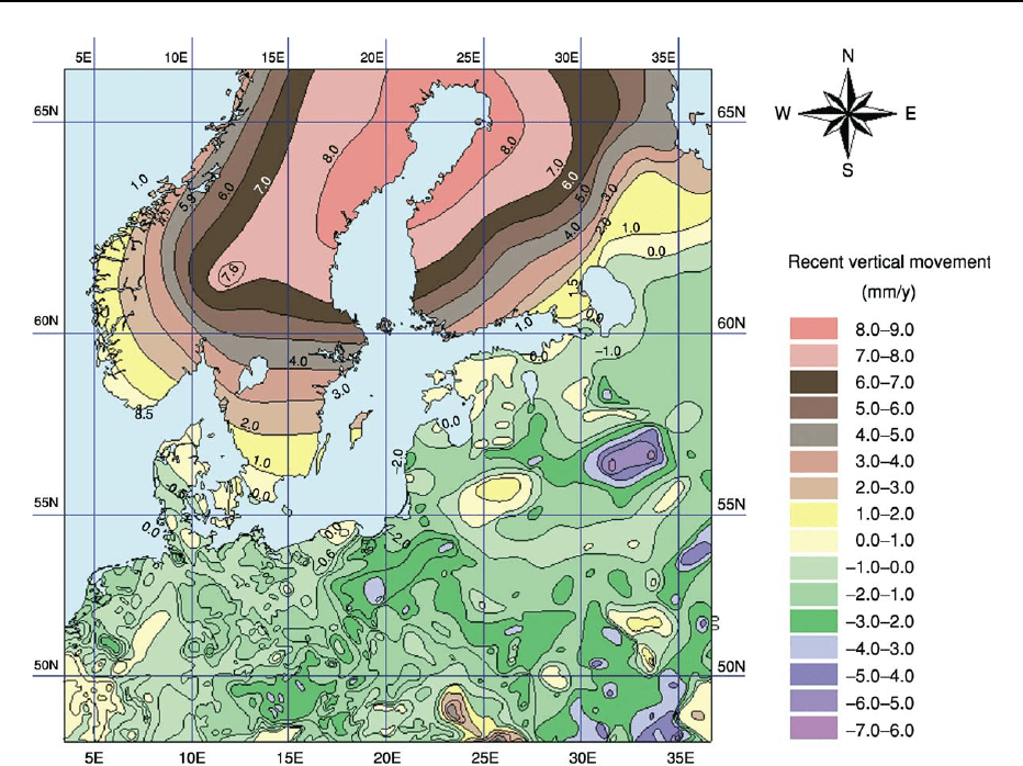
Figure 5 Recent vertical movement of the Earth’s crust. In the northern part the map is dominated by the extensive, north-east-
south-west-stretched uplift of Fennoscandia with maximum values of >8 mm year. The subsidence of a belt surrounding the Baltic
Shield is less differentiated. (From Harff J, Frischbutter A, Lampe R, and Meyer M (2001) Sea-level change in the Baltic Sea:
interrelation of climatic and geological processes. In: Gerhard LC, Harrison WE, and Hanson BM (eds.)
Geological perspectives of global
climate change
. Tulsa, Oklahoma, American Association of Petroleum Geologists in collaboration with the Kansas Geological Survey
and the AAPG Division of Environmental Geosciences: 231–250. Reprinted by permission of the AAPG whose permission is required
for further use.)
150 EUROPE/Holocene
is called Ancylus Lake, with reference to a typical
freshwater snail occurring in these waters (Ancylus
fluviatilis)(Figure 9). This freshwater stage lasted
more than two thousand years and was characterised
by considerable short-term water level fluctuations. As
differential isostatic uplift continued, the critical
thresholds between the Baltic Basin and Kattegat
moved from southern Sweden to the recent-formed
Danish Straits. At about 8000 years BP, the eustatic
sea-level rise led to the first ingressions of marine
waters into the Baltic Basin. In pace with the rapidly
rising global sea-level, the thresholds were flooded
and a stable connection between the Kattegat and the
Baltic Basin was formed. This crucial phase of
the Baltic Sea’s evolution is called the Littorina trans-
gression, after a marine snail which is common in
deposits of this period (Littorina littorea). At the
onset of the Littorina transgression, the water level
rose at a rate of 25 mm year within the south-western
Baltic Basin (eustatic rise added to crustal subsidence,
as described above), which slowed down later to
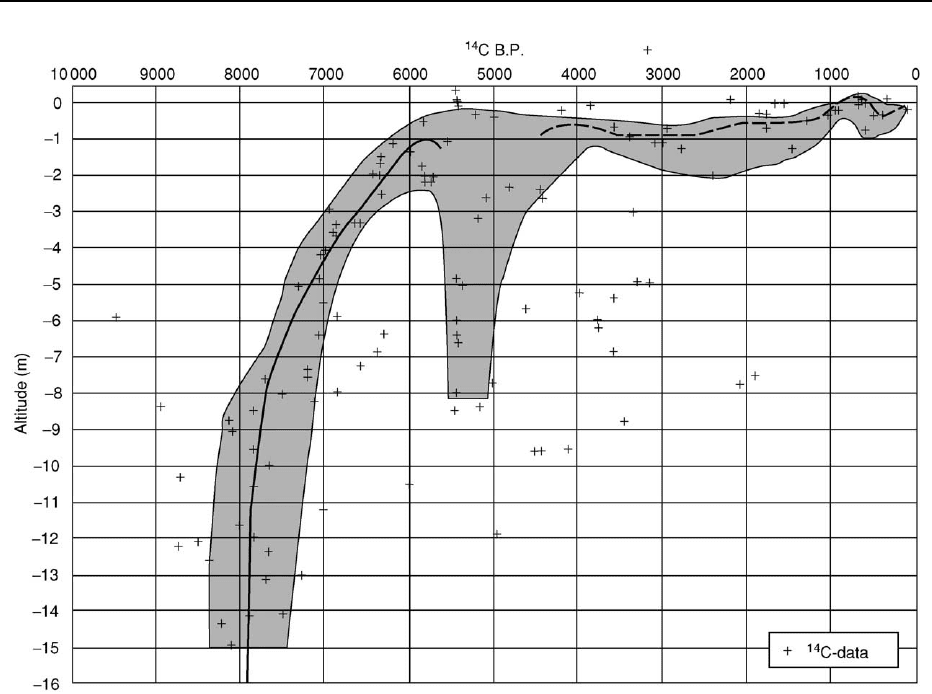
about 3 mm year at about 4500 years BP (Figure 10).
During a time-span of less than a thousand years, the
sea-level rose by more than 20 m, implying enormous
rates of coastal retreat within the southern Baltic
Basin. Due to the rapidly rising sea-level at the begin-
ning of the Littorina Stage, the glaciogenically-shaped
land relief was drowned without any notable coastal
erosion and longshore transport processes of sedi-
mentary material. The resulting geographical situ-
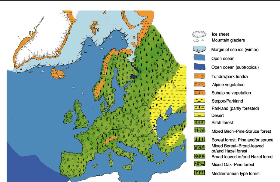
ation is shown in Figure 11. Only after the sea-level
rise slowed down at the end of the Littorina Stage
(about 2000 years BP), and during the Post-Littorina
Stage, was the recent spit and barrier coast formed by
erosion and sediment transport. This process was
mainly controlled by climatic factors, such as the
wind-driven hydrographic regime which was super-
imposed on long-term eustatic and isostatic move-
ments which have caused rising relative sea-levels
and coastal retreat at the southern Baltic shores in
recent times. Further north in Fennoscandia, isostatic
uplift continuously exceeded the eustatic sea-level
rise, resulting in a permanent general sea regression
(Figure 7).
The changing Holocene sea level within the Mediter-
ranean basins was and is mainly controlled by eustatic
processes. In contrast to northern Europe, glacio-
isostasy does not play a significant role. On the other
hand, this region occupies the junction between the
African-Arabian and the Eurasian plates which gives
considerable tectonic activity in the different sediment-
ary basins of the Mediterranean Sea. Therefore, the
general picture of the sea-level, development which
reflects the eustatic curves, is superimposed on the
regional and local tectonics.
A matter of ongoing discussion is the possibility of
the reconnection of the Black Sea and the Mediterra-
nean Sea during the period of Holocene sea-level rise.
A catastrophic flood scenario at about 7500 years BP
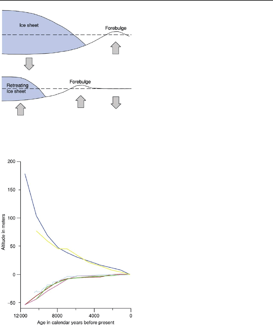
Figure 6 Principle of glacio-isostatic vertical crustal move-
ments: (a) Ice load causes subsidence of the Earth’s crust
below and compensatory uplift beyond the ice margin as a fore-
bulge; (b) Uplift of the ice-released Earth’s crust and related
displacement of the forebulge. (Modified after Daly 1934.)
Figure 7 Schematic Holocene relative sea level curves for
different European regions (blue = Oslo, Norway; yellow =
south-eastern Sweden; light blue = southern Baltic Sea; brown
= French Atlantic coast; green = Netherlands; purple = central
Mediterranean).
EUROPE/Holocene 151
is questioned because of indications of a more com-
plex and progressive transgression process over the
past 12 000 years.
Interrelation of Human Activity and
Natural Environment
In terms of human history, the onset of the Holocene
is equivalent to the beginning of the Mesolithic
period, which is characterised by prevailing hunter,
fisher, and gatherer societies in Europe. The tempera-
ture rise at the end of the Younger Dryas caused an
accelerated deglaciation. Alpine glaciers retreated to
historical dimensions and the receding inland ice in
Scandinavia was followed successively by tundra,
steppe, and finally forests. This was accompanied by
an enhanced northward migration of animals and
their Mesolithic hunters. The rapidly changing nat-
ural environment, possibly in combination with
human activity, resulted in the extinction of some
characteristic genera of the Pleistocene megafauna
such as the mammoth (see Tertiary To Present: Pleis-
tocene and The Ice Age). Another consequence of the
rapidly changing landscapes was a very variable
migration pattern of the Mesolithic hunter, fisher,
and gatherer groups in central and north-western
Europe.
The following Neolithic period was closely con-
nected with the introduction of farming in the various
geographical regions. The first Neolithic settlements
in southern Europe (Greece) are dated to about 9000
calendar years BP. In northern Germany, southern
Scandinavia and the British Isles, they are more than
3000 years younger. Coming from the Near East, the
new method of food-procurement spread to the Great
Hungarian Plain in a first wave from 8200–7800
years BP. A second leap entered the North European
Plain at around 7400 years BP. Neolithic settlers from
Southeast Europe migrating along the rivers Danube
and Rhine were probably responsible for the conse-
quent social and cultural changes. In parts of Europe
(e.g., western Mediterranean and northern Europe)
the native Mesolithic population adopted agricultural
methods to form a transitional economy.
While the hunter-fisher-gatherer societies of the
Mesolithic used and manipulated the natural ecosystem
without altering it considerably, the Neolithic farmers
started to transform the environment according to their
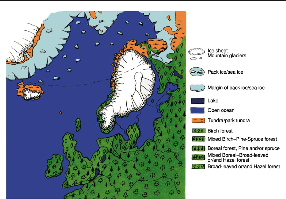
Figure 8 North-western Europe during the Yoldia Sea stage of the Baltic Sea’s history (about 11 000 years BP). (From Andersen BG
and Borns HW (1994)
The ice age world: an introduction to Quaternary history and research with emphasis on North America and Europe during the
last 2.5 million years
. Oslo: Scandinavian University Press, with permission.)
152 EUROPE/Holocene
needs. Cultivation started within rather small (perhaps
pre-existing) open land patches in the Early Neolithic.
In this phase clearances remained localised and the early
Neolithic farmers were still highly dependent on intact
natural habitats surrounding the cultivated land
patches.
This situation changed in the later part of the Euro-
pean Holocene, when increasing demand for agricul-
tural products induced a major transformation of the
yet still mainly natural environment into an agricul-
tural one. This process was certainly time-transgres-
sive and affected some European regions more than
others. But, far from being controlled solely by
human action, natural feedback, combined with
differing vulnerability of the existing ecosystems,
amplified, shifted, or interfered with the initial direc-
tion of processes initiated by human activity. In order
to adapt to the partly self-induced new conditions,
human societies had to react by further cultural de-
velopment which accelerated the general transform-
ation process of the natural environment. This is
exemplified by the domestication of animals which
were advantaged by the anthropogenically influenced
environment, while on the other hand natural com-
petitors and predators became progressively extinct
by hunting kill-off or simply by loss of habitat (exten-
sive land use by farming). The same applies to floral
assemblages, as initially, their composition was
governed by natural conditions but it became increas-
ingly influenced by agriculture. This development
finally produced an increasing interdependence of
cultivated plants and animals with mankind. Societies
like the Irish people in nineteenth century, for exam-
ple, were greatly dependent on potato growth. When
the Late Potato Blight ruined all the potato crop in
Ireland in the 1840s, the resulting famine lead to
dramatic consequences. About 1 million people died
while another 1.5 million people emigrated.
The stability of the cultural landscape which had
evolved out of the interplay between natural and
human influences, as well as that of human societies
living there, depended on the state of their equilib-
rium. Changes of the natural component could cause
considerable impact to the progressively complex
human society and this is exemplified by climatic or
geological influences. Some historical epochs with a
prospering economy and politically stable conditions
are connected with warmer periods.
Colder climate deviations often were characterised
by political and economical instability. This refers,
for example, to the time of the Germanic migrations
about 450–700 ad and the Little Ice Age between
1500 and 1800 ad. Rather short-term, but possibly
catastrophic, impacts derived from events like
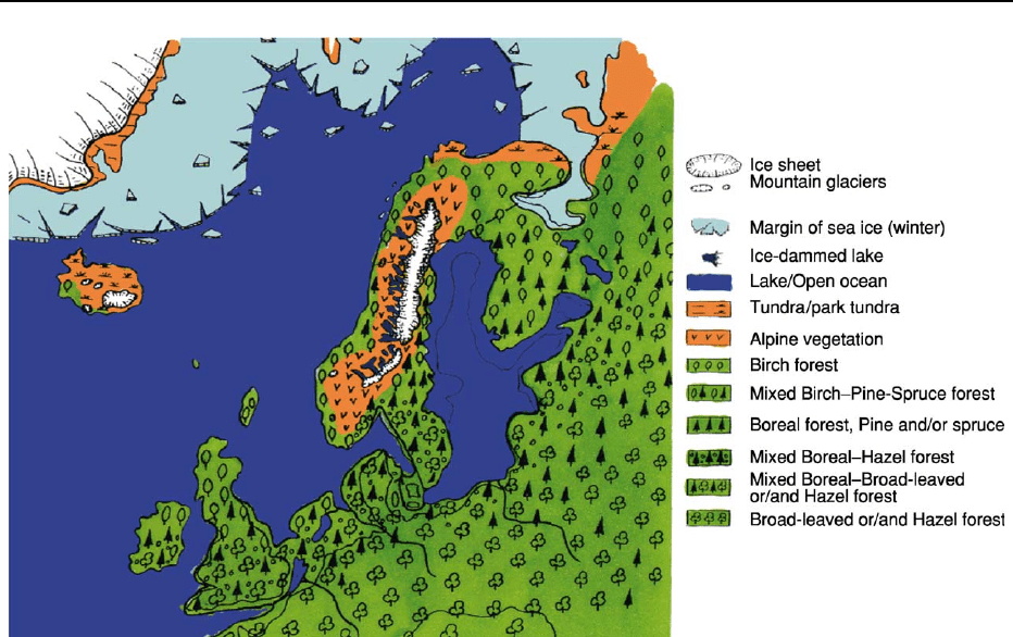
Figure 9 North-western Europe during the Ancylus Lake stage of the Baltic Sea’s history (about 9500 years BP). (From Andersen BG
and Borns HW (1994)
The ice age world: an introduction to Quaternary history and research with emphasis on North America and Europe during the
last 2.5 million years
. Oslo: Scandinavian University Press, with permission.)
EUROPE/Holocene 153
volcanism (e.g., the eruption of Vesuvius in ad 79
described by Pliny the Younger), earthquakes (e.g.,
the disastrous one of Lisboa in ad 1755) or floods
along rivers and seashores.
On the other hand, changing social conditions also
induced dramatic changes of their natural environ-
ment. Once human activity stopped or declined, the
surrounding environment developed depending on its
natural stability. Robust ecosystems changed back
to a state similar to the original one being controlled
by the natural conditions. An example for such pro-
cesses is the re-forestation after depopulation during
the Thirty Years’ War (1618–1648 ad) in central
Europe.
In other cases, human activity led to irreversible
effects on the ecosystem’s stability when the social
structures collapsed. During the Roman period there
was a land use maximum partly on metastable
soils. Here, terraces were maintained, preventing soil
erosion. After the invasion of eastern nomads, the
land was partly abandoned and soil erosion started
at a greater extent and in the worst case, barren bad-
lands were the final result. Therefore, maximum ero-
sion is not connected with maximum land use, but
with subsequent phases in different cultural environ-
ments. Generally, when judging human impact on the
natural environment, it is often regarded only as
negative. However, in contrast, the creation of new
metastable ecosystems more diverse than before, par-
ticularly in the early phases of the Holocene, would
not have been possible without human activity.
Human Activity and Environmental
Conservation
During the last 500 years, human impact on the
European environment have become much more im-
portant than the natural conditions. Particularly
Figure 10 Preliminary curve of relative sea-level change for western Pomerania, shaded area: interval of ‘data confidence’, solid
line: local trend for western Pomerania, dashed line: estimated trend, for the time span between 6000 and 4500 years BP tectonically
controlled local uplift is assumed. Note: Ages are given here in
14
C years BP. (From Harff J, Frischbutter A, Lampe R, and Meyer M
(2001) Sea-level change in the Baltic Sea: interrelation of climatic and geological processes. In: Gerhard LC, Harrison WE, and Hanson
BM (eds.)
Geological perspectives of global climate change. Tulsa, Oklahoma, American Association of Petroleum Geologists in collabor-
ation with the Kansas Geological Survey and the AAPG Division of Environmental Geosciences: 231–250. Reprinted by permission of
the AAPG whose permission is required for further use.)
154 EUROPE/Holocene
within the last hundred years, industrial methods in
agriculture have resulted in a widespread conversion
of natural habitats into farming land. Accelerated
human-induced soil loss has become a major prob-
lem. Measures initiated to solve the problems of
modern agriculture, for example, to protect the soil
against nutrient depletion, partly result in adverse
effects such as eutrophication.
One of the most severe impacts on environment
is connected with the beginning of industrialisation.
Natural resources which had accumulated over mil-
lions of years have been exploited within decades or
less. Large industrial facilities have been built on ter-
rain of formerly less affected landscapes. Moreover,
military needs have modified great parts of the ter-
rain. Growing populations all over Europe have
enhanced the conversion of natural habitats into
settlement areas. At the same time, the management
of industrial and municipal waste has become a major
issue. The effects of industrialisation are reflected by
many proxies such as the concentration of heavy
metals in sub-recent deposits (Figure 12).
All these tendencies have developed ideas on nature
conservation, sometimes with the idealistic approach
of going back to a state where human influence is
negligible. Nature conservation in this context may
be regarded as a contradiction in itself because it
does not recognise the vital role of human society
for the natural environment. Large areas along the
Netherlands’s coast would have been flooded if the
coast was not protected by coastal engineering. Fur-
thermore, the dynamic character of the environmen-
tal status must be considered. For the last 8000 years
of the Baltic Sea’s history it can be shown, for exam-
ple, that high nutrient levels already existed immedi-
ately after the Littorina Transgression. Without any
remarkable human influence, organic substances and
nutrients could accumulate in the sediments because
of restricted vertical convection. This process has
been intensified during the last centuries and decades
by agriculture and the industrial release of nutrients
(Figure 13). Thus, if the Helsinki Commission for the
protection of the Baltic Sea aims to restore the eu-
trophication level of the 1950s, it must be stated
that that was just one time slice of the Baltic Sea’s
Holocene development. One might be successful in re-
establishing the concentrations of certain nutrients,
but it would be in a completely different new context.
As human society develops further, it cannot be
expected that there will be no response by the natural
environment. A certain equilibrium, including the
benefit for as many species as possible including
Figure 11 Europe about 4500 years BP. (From Andersen BG and Borns HW (1994) The ice age world: an introduction to Quaternary history
and research with emphasis on North America and Europe during the last 2.5 million years
. Oslo: Scandinavian University Press, with
permission.)
EUROPE/Holocene 155
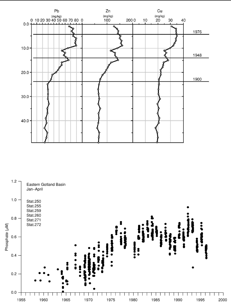
Figure 12 Enrichment of heavy metals within the last century, as recorded in a sediment core from the Arkona Basin (western Baltic
Sea). (From Th. Leipe, Baltic Sea Research Institute Warnemu
¨
nde, with permission.)
Figure 13 Trends of winter phosphate concentrations in the surface layer (0–10 m) of the eastern Gotland Basin (central Baltic Sea).
(From G. Nausch, Baltic Sea Research Institute Warnemu
¨
nde, with permission.)
156 EUROPE/Holocene

Table 1 Summary of the climatic and historical development during the European Holocene
Calendar
years BP
Environmental
Period General climatic features Selected historical events
Stages of the Baltic
Sea’s development
Modern climatic optimum, warm World War I and II Mya Sea
200 Subatlantic
French Revolution
Little Ice Age, mean annual
temperature in Europe 1
C
lower than today, cold winters,
but pronounced fluctuations,
glacier advances
Less brackish
400 Thirty Years’ War Mya Sea
Lymnaea Sea
Renaissance and reformation Brackish
600
Bubonic plague kills about one third
of the European population
Transition to colder conditions
800
Medieval climatic optimum, mean
annual temperature 1–1.5
C
higher than today, winegrowing
as far north as to the British
Isles, first dry, later wet
Brackish
Subatlantic
1000
Expansion of Norman people as far
as Iceland, Greenland, North
America and southern Russia
1200
Cold and wet period, many
glacier advances
1400
Subatlantic End of the Roman Empire Slightly brackish
1600
Invasion of the Huns forces the
emigration of nations
Lymnaea Sea
1800
2000 Roman climatic optimum, as
warm as the Medieval
optimum, mostly very wet,
towards the end more dry
Foundation of the Roman Empire
First southward migrations of
Gothic tribes
2200
Pronounced cold period, mean
annual temperature 1–1.5
C
lower than today, very cool
summers, very wet, large
glacier advances
Celtic La Te
`
ne culture in big
parts of Europe
2400
Beginning of the Greek classic period
Formation of the Roman Republic
2600 Celtic Hallstatt culture in central and
western
Subatlantic Europe introduces the iron age
Subboreal Greek Archaic period
2800
3000 First Celtic tribes in eastern and
central Europe
Brackish
3200
(Continued)
EUROPE/Holocene 157

Predominantly warm with Distinct
fluctuations, less precipitation
than during Subatlantic
Urn field culture in central and
South-eastern Europe
3400
First bloom of the Mycene culture in
Greece
3600
Beginning of the Bronze Age in
northern Europe
3800 Subboreal
Cold period with glacier
advances, initially dry,
later more wet
4000
4200 In Europe exists an extensive trade
route network
4400
Early Minoic culture at Crete Island
launches the European Bronze Age
4600
4800
5000 Increasing influence of Indo-European
people all over Europe
5200 Introduction of the wheel in Europe
5400 Megalithic monuments in many regions
of central and western Europe
Brackish
5600 Subboreal
5800 Atlantic
6000 Narva-culture in North-eastern Europe
6200 Rapid increase of humidity in
eastern central Europe
First stone buildings at the Orkney
Islands
6400 First Neolithic settlements at the
British Isles
Warm period, mean annual
temperatures 2–3
C warmer
than today, especially warm
winters, very moist, former
predominant pines are
replaced in the forests by oaks,
lime and hazel
6600
Late Mesolithic Ertebølle - culture
in northern central Europe
6800
7000 Neolithic Karanovo – culture in
South-eastern Europe
7200 Late Mesolithic Ertebo
¨
lle culture in
northern Europe
7400 Neolithic ‘Bandkeramik’ – culture in the
Loess areas of central Europe
7600 Strongly brackish
7800
Mesolithic Kongemose culture in
northern Europe
Littorina Sea
8000
(Continued)
Table 1 Continued
Calendar
years BP
Environmental
Period General climatic features Selected historical events
Stages of the Baltic
Sea’s development
158 EUROPE/Holocene

mankind is desirable. Closed production cycles might
be one of the important targets to achieve this.
Actualism in a New Context
The special character of the Holocene as a period
which is not only part of the geological past but also
an interface with the future, gives the principle of
actualism a new dimension. In addition to regarding
the present as being the key to the past, past and
present times might be regarded as a key to the future.
Predictions of future developments become more and
more important to cope with possible changes in
the natural environment. For this purpose, detailed
knowledge about similar processes in the past is
indispensable. In order to calibrate proxies from the
geological record, it is necessary to analyse recent
proxies by comparison with older ones, and also the
Table 1 Continued
Calendar
years BP
Environmental
Period General climatic features Selected historical events
Stages of the Baltic
Sea’s development
Short lived cold interval, drop of
the mean annual temperature
by 2
C
Ancylus Lake
8200 First Neolithic agricultural societies in
South-eastern Europe and Greece
Freshwater
8400
The English Channel separates
the British
8600 Slightly warmer and moister
than today
Isles from the continent
8800
9000 Atlantic Hunter and gatherer societies
Boreal Cold phase in the Carpathian
Basin
9200
During summers generally
warmer than today, mainly
open winters
Maglemose-culture in northern Europe
9400
Azilian culture in western Europe
9600
Microliths become common
9800
Use of log-boats is proven
10000
10200 Boreal
Preboreal Nomadic hunters arrive in England
10400
Ahrensburg culture in northern Germany
Freshwater
10600
Summers as warm as today,
but very cold winters
10800 Ancylus Lake
Yoldia Sea
11000 Freshwater
11200 Regionally
brackish
11400 Quick warming Bromme culture in Denmark
Freshwater
11600 Preboreal Beginning of the Holocene Mesolithic Yoldia Sea
Younger Dryas End of the Pleistocene Palaeolithic Baltic Ice Lake
11800
12000 Cold period, mean annual
temperatures by 5–9
C
lower than today
Freshwater
EUROPE/Holocene 159
