Cotton W.R., Pielke R.A. Human Impacts on Weather and Climate
Подождите немного. Документ загружается.

Dust 89
But in simulations of entrainment of Saharan dust into Florida thunderstorms,
van den Heever and Cotton (2004) found that dust impacts not only the cloud
microphysical characteristics but also the dynamical characteristics of convective
storms as well. The variations in cloud microstructure and storm dynamics by
dust, in turn, alter the accumulated surface precipitation and the radiative proper-
ties of anvils. These results suggest that the whole dynamic structure of the storms
is influenced by varying dust concentrations. In particular, the updrafts are consis-
tently stronger and more numerous when Saharan dust is present compared with
a clean airmass. This suggests that the clouds respond to dust in a similar way to
the dynamic seeding concepts discussed in Chapter 2. That is, the dust results in
enhanced glaciation of convective clouds which leads to dynamical invigoration
of the clouds, larger amounts of processed water, and thereby enhanced rainfall at
the ground (Simpson et al., 1967; Rosenfeld and Woodley, 1989, 1993). However,
van den Heever et al.’s simulations resulted in reduced rainfall on the ground at
the end of the day. During the first few hours dust enhanced precipitation but by
the end of the day, the clean aerosol simulations produced the largest surface rain
volume.
Overall, the evidence is compelling that anthropogenic emissions of aerosols
and gases are having an impact on the stability of cloud layers, cloud cover-
age, cloud microstructure, cloud dynamics, precipitation processes, and cloud/fog
occurrence.
5
Urban-induced changes in precipitation and weather
5.1 Introduction
In Chapter 4, we examined the possible effects of particulate and gaseous emis-
sions on precipitation and weather on the regional scale in a general sense rather
than specific urban-induced changes. In this chapter, we examine the evidence
suggesting that pollutants as well as other urban effects are causing changes in
the weather and climate in and immediately surrounding urban areas.
There is considerable evidence which suggests that major urban areas are caus-
ing changes in surface rainfall, increased occurrences of severe weather, especially
hailfalls, and alterations to surface temperatures (Ashworth, 1929; Kratzer, 1956;
Landsberg, 1956, 1970; Changnon, 1968, 1981a; Changnon and Huff, 1977, 1986;
Hjelmfelt, 1980; Oke, 1987). Some of the hypothesized causes of those changes
include:
• urban increases in CCN concentrations and spectra, and IN concentrations;
• changes in surface roughness and low-level convergence;
• changes in the atmospheric boundary layer and low-level convergence caused by urban
heating and land-use changes; and
• addition of moisture from industrial sources.
A major cooperative experiment was carried out in the St. Louis, Missouri
area in the 1970s to identify urban-induced changes in weather and climate
and to identify the primary causes of those changes. A comprehensive review
and summary of the experiment and its results are described in the monograph
METROMEX: A Review and Summary (Changnon, 1981b). In this section we
draw heavily on those findings to discuss the potential mechanisms causing urban-
induced changes in weather and climate.
First of all METROMEX and related studies showed that St. Louis exhibits a
major summertime precipitation anomaly relative to the surrounding rural area.
The area-average urban-related increase is about 25%. Much of the enhanced
90
Urban increases in CCN and IN 91
rainfall occurs during the afternoon (1500 to 2100 local daylight time (LDT)),
over the city and the close-in area east and northeast. The clouds producing those
changes are deep convective clouds and thunderstorms. In fact the frequency of
thunderstorms is enhanced in that region by 45% and hailstorms increased by
31%. Not only is the hailstorm frequency higher, but hailstones are larger and
of greater number. The rainfall observations also indicated a maximum around
midnight extending from approximately 2100 to 0330 LDT located northeast of
the city. Changnon and Huff (1986) estimated that the area experienced a 58%
increase in nocturnal rainfall relative to the surrounding countryside. The storms
responsible for the nocturnal maxima were well-organized storms such as squall
line thunderstorms that swept across the urban area and moved across the affected
region.
How does an urban area cause those changes? Let us examine each of
the hypothesized mechanisms and see how well each fits the METROMEX
observations.
5.2 Urban increases in CCN and IN concentrations and spectra
Not surprisingly, anthropogenic activity in the St. Louis urban area caused major
increases in CCN concentrations; as much as 94%. Droplet size distributions
as a result were found to be narrower with larger concentrations of droplets
in the clouds downwind of the city compared to upwind. Large numbers of
large, wettable particles, having radii greater than 10 m with many as large
as 30 m were found over the city. These “ultra-giant” particles can serve as
embryos for initiation of collision and coalescence. This is consistent with the
finding that clouds over the city did have a greater number of larger droplets.
The METROMEX scientists cautioned, however, that they had less confidence
in those observations compared to the observed higher concentrations of small
cloud droplets.
Similar to the study of paper pulp mills, the METROMEX modeling studies
revealed that the time required to initiate precipitation in upwind and downwind
clouds was only different by a few minutes. It was therefore concluded that the
anthropogenic CCN do not play a major role in the creation of the urban rainfall
anomaly.
It was also found that the concentrations of IN were not greatly altered over and
downwind of the urban area. If anything, it was found in the winter months that
the IN concentrations were actually less over the urban region. This suggested
that the coagulation of the few IN with the more numerous anthropogenic aerosol
actually deactivated or “poisoned” the IN.
92 Urban-induced changes in precipitation and weather
In summary it does not appear that the anthropogenic emissions of aerosols can
by themselves cause the observed increases in rainfall. It is possible that changes
in the cloud and raindrop spectra can have an impact on the rate of glaciation
of a cloud and thereby the subsequent cloud behavior. We will examine this
hypothesis next as the glaciation mechanism.
5.3 The glaciation mechanism
As noted in Part I, it is generally accepted that cumuli containing supercooled
raindrops glaciate more readily than more continental, cold-based cumuli that do
not contain supercooled raindrops. There are several reasons for this. First of all,
larger drops freeze more readily than smaller drops by immersion freezing. More
importantly, as noted in Part I, the coexistence of large, supercooled drops and
small ice crystals, nucleated by some mechanism of primary nucleation, favors
the rapid conversion of a cloud from a liquid cloud to an ice cloud (i.e., glaciation)
(Cotton, 1972a,b; Koenig and Murray, 1976; Scott and Hobbs, 1977). Thus the
ultra-giant particles observed over St. Louis could produce more supercooled
raindrops which would accelerate the glaciation process. This process does not
require any change in IN concentrations.
A second factor potentially affecting the rapid glaciation of urban clouds is that
the altered drop-size spectra could initiate secondary production of ice crystals.
Laboratory studies have indicated that copious quantities of ice splinters are
produced when an ice particle collects supercooled cloud droplets when cloud
temperatures are within the range of −3to−8
C, and when the cloud is composed
of a mixture of large drops (greater than 125 m radius) and small droplets (less
than 7 m ). All these criteria were met in the clouds observed over St. Louis
during METROMEX.
As noted by Keller and Sax (1981), however, in broad, sustained fast-rising
updrafts, even when all the criteria for secondary ice production are met, the
secondary ice particles and graupel particles will be swept upwards out of the
limited temperature range favorable for secondary ice crystal production. Until the
updrafts weaken and graupel particles settle into the secondary production zone,
the positive feedback mechanism of secondary production is broken. Therefore
the opportunities for rapid and complete glaciation of a cloud are greatest if the
cloud has a relatively weak, steady updraft or the updraft is a pulsating convective
tower. We will show that the clouds over the St. Louis urban area had less buoyant
energy or CAPE (as evidenced by lower values of
e
)
1
than rural clouds. Thus the
1
e
, called equivalent potential temperature, is a conservative variable for wet adiabatic processes. See Cotton
and Anthes (1989) and Pielke (1984) for a mathematical definition of
e
.
Impact of urban land use on weather 93
clouds over the urban area would be expected to have weaker updraft strengths
as they enter freezing levels than rural clouds, further enhancing the potential for
rapid and complete glaciation.
The hypothesis then builds on the dynamic seeding hypothesis described in
Part I. That is, the rapidly glaciated, urban clouds would explosively deepen after
they penetrate into subfreezing temperatures, process more moisture through their
greater depths, live longer, and rain more. Evidence supporting the glaciation
hypothesis is as follows. First of all, it was observed during METROMEX that
cumuli over the adjacent rural areas exhibited a distribution in cloud top heights
that was bimodal, with many clouds terminating at a height of about 6 km and
many others rising to 12 km, but with few clouds penetrating just to heights
of around 9 km. In contrast, urban cloud top heights had a more continuous
distribution with cloud top heights at all levels between 5 and 13 km. One
interpretation of these measurements is that enhanced glaciation of the urban
clouds allowed more clouds to penetrate upward through an arresting level, such
as an inversion in temperature or a dry layer, and thereby rise to greater heights.
The fact that there is a downwind maximum in thunderstorm activity and hail is
consistent with more vigorous glaciation of the clouds as well. Finally the finding
that merger of clouds was more frequent over the urban area is consistent with
the dynamic seeding hypothesis (Simpson, 1980).
Unfortunately enhanced glaciation of urban clouds was never directly observed
during METROMEX. This is because the airborne sensors used were not capable
of discriminating between glaciated and unglaciated clouds. Thus this mechanism
remains an unproven hypothesis.
5.4 Impact of urban land use on precipitation and weather
Except for the Ohio River valley in the immediate area of the city, St. Louis is
located in a vast farmland on a relatively flat plain. The presence of a major urban
area changes the surface properties markedly. Firstly, the presence of buildings,
particularly tall downtown structures, alters surface roughness from the relatively
smooth cropland and occasional forest to a very rough surface. This rough surface
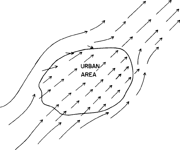
creates surface drag which slows the winds near the ground. As shown in Fig. 5.1,
air approaching the city would slow down and tend to divert around the city
something like flow around an isolated rock in a stream. On the downwind side
of the city, air streaming around the city would tend to converge, causing upward
motion in that region. There are documented cases where changes in surface
roughness have led to a slowing down of cold fronts upwind of New York City, and
acceleration of the front downwind (Loose and Bornstein, 1977). Bornstein and
94 Urban-induced changes in precipitation and weather
Figure 5.1 Schematic illustration of low-level airflow over and around a major
urban area due to changes in surface roughness.
Leroy (1990) found that moving thunderstorms split upon experiencing a barrier-
induced divergence around the New York City complex, resulting in enhanced
precipitation along the lateral edges of the city and downwind of the city. Analysis
of winds and precipitation over Atlanta, Georgia by Bornstein and Lin (2000)
suggests that a similar barrier-induced effect is present there as well.
Even more important are the changes in the heat and water budget at the
surface caused by the presence of a city. In the countryside, the Earth’s surface
consists of fallow and plowed fields, grasslands, and small forested areas. The
soils are, relative to much of the urban area, rather moist and contain vegetation
which can transfer significant amounts of moisture to the atmosphere. By contrast,
the surface in the city is a rather impermeable layer, consisting of a mixture of
concrete, asphalt, and buildings with a relatively small area of undisturbed soils
and vegetation. A greater fraction of rainfall therefore runs off in urban areas than
in the countryside.
These changes in surface properties alter the surface energy budget in two
ways. First of all, in an urban area such as found in the central United States,
a greater fraction of the incoming solar radiation is reflected over the cities as
the concrete and buildings are more reflective than plowed fields and cropland.
This greater reflectance, or what we call albedo, has a cooling effect over the
Impact of urban land use on weather 95
urban areas. Secondly, the more moist land surfaces over the countryside cause
a greater fraction of the solar energy absorbed at the surface to be converted
into latent heat release rather than sensible heat transfer. In other words, much of
the absorbed energy goes into evaporating water from the soil and transpiration
from the vegetative canopy. This causes a cooling effect in rural areas relative to
the drier, less vegetated urban areas. Because the impact of creating a drier, less
vegetation-covered soil in the urban area is much greater than the cooling effect
of increased albedo over urban areas, the urban areas in a humid climate such as
St. Louis warm more quickly than the surrounding countryside. In addition, the
heat stored in concrete and asphalt leads to the urban area remaining warmer later
into the evening than the surrounding countryside. Other factors such as heat and
moisture emissions by industry, automobiles, and buildings contribute to heating
of the urban area relative to the countryside. All heating leads to what is called
an urban heat island.
During METROMEX, St. Louis was shown to have a well-defined heat island
centered over the downwind commercial district, northeast of the core of the urban
area. Its maximum size and intensity occurred between midnight and 0600 LDT.
It was also found that the air immediately above the urban area was usually drier
than over nearby rural areas. Let us consider the hypothetical diurnal variation of
the boundary layer of the urban area.
At sunrise, air temperatures begin to rise over both the rural and urban areas.
Owing to a shallower nocturnal inversion over the country than the city, air
temperatures rise more quickly over the countryside at first. As the ground is
heated in both the urban and rural areas, however, a mixed layer forms which
deepens more rapidly over the city than the rural areas. This is because the low-
level nocturnal inversion strength is weaker over the city. By midday, heating
proceeds more rapidly over the city because more of the absorbed energy goes into
sensible heat rather than latent heat. The boundary layer thus becomes increasingly
deeper and drier over the city. On typical afternoons, the urban boundary layer
was found to be 100 to 400 m deeper over St. Louis than the rural areas.
Figure 5.2a illustrates a late afternoon vertical cross-section over the city show-
ing a deeper urban boundary layer, that is warmer and drier than the countryside.
Associated with this warmer and drier pool of air over the city is rising motion
which produces a sea-breeze-like circulation between the city and the countryside.
As seen in Fig. 5.2b this rising motion over the city draws low-level air into
the city causing low-level convergence. Such low-level convergence has been
found to be favorable for producing deep, precipitating cumulus clouds and also
increases the likelihood that those clouds will merge in this low-level conver-
gence zone to produce bigger, heavier raining clouds (Pielke, 1974; Ulanski and
Garstang, 1978a,b; Chen and Orville, 1980; Simpson et al., 1980; Tripoli and

96 Urban-induced changes in precipitation and weather
Z (m)
2000
1000
COOL
MOIST
COOL
MOIST
COOL, MOIST
(WARM)
DRY
(a)
(b)
URBAN
WARM, DRY
INVERSION
Figure 5.2 (a) Schematic vertical cross-section over a major urban area during
the late afternoon in a humid climate region illustrating the effects of the urban
heat island. (b) Similar to (a) except a horizontal map of the altered low-level
winds by the heat island in the absence of large-scale prevailing flow.
Cotton, 1980). The maximum convergence would occur somewhat downwind of
the urban area as the heated boundary layer is advected in that direction (Mahrer
and Pielke, 1976; Hjelmfelt, 1980).
During the evening hours, heat conduction from the ground in the urban area
limits the rate of cooling compared to the countryside. The surface remains warmer
and the low-level air is less stable than in the rural areas. Thus the heat island
remains stronger over the city throughout the night.
In the next subsections, the observed behavior of clouds and precipitation over
and downwind of St. Louis are discussed to see if they are consistent with changes
in the urban boundary layer.
Impact of urban land use on weather 97
5.4.1 Observed cloud morphology and frequency
Clouds over the St. Louis urban area were found to have bases 600 to 700 m
higher than rural clouds. This is consistent with the observation that the air over
the city is warmer and drier. The exception was clouds downwind of refineries,
where it is believed that moisture injections by the refineries caused lower cloud
bases. Air motion into the bases of the clouds were stronger which is consistent
with the expected more vigorous thermals due to the heat island.
Cloudiness (defined as the percent coverage of clouds over an area) was found
to be greater over the urban area in the later afternoon (1600 LDT) consistent
with the observed convergence and upward motion due to the heat island.
5.4.2 Clouds and precipitation deduced from radar studies
The first detectable radar echoes is a measure of the initiation of precipitation.
Echoes were found to be more frequent over the urban area during the late
morning, about 1400 LDT, and after 1930 LDT. This suggests that the heat-
island-induced convergence field played a major role in creating precipitating
cumuli. Moreover, individual cumulus cells over the urban area were found to
grow deeper and have slightly longer durations than over the rural areas. Again,
this is consistent with stronger convergence over the urban heat island favoring
deeper, longer-lasting precipitating cumuli.
Clouds over the urban area were also found to merge more frequently with cells
over the city, grew taller, and lasted longer than did merged cells over rural areas.
As noted previously, this is consistent with observations and modeling studies
which suggest that cloud merger is enhanced by low-level convergence, such as
that caused by the urban heat island effect. Because it is generally found that taller
and longer-lasting cells create more rain and a greater likelihood for hail, these
findings are consistent with the hypothesis that the urban heat island enhances
convective rain systems over and downwind of the city.
Analysis of cells that contributed to the nocturnal rainfall maxima downwind of
St. Louis (Changnon and Huff, 1986) suggested that this urban-related anomaly
was associated with the enlargement of rain areas from well-organized storms
that existed upwind of St. Louis and then moved over and downwind of the city,
as well as the development of new cells over the urban area. Changnon and Huff
(1986) and Braham (1981) speculated that this behavior of the storms may have
been due to the injection of drier air into the storms as they passed over the urban
area, causing them to weaken prematurely and release stored water downwind
of the city. This interpretation, however, is inconsistent with the observation that
organized, nocturnal storms normally draw on air that has its origin over a large
area 50 or more kilometers away from the storm. This warm, moist air typically
98 Urban-induced changes in precipitation and weather
glides over the nocturnal low-level inversion so that the nocturnal storms do
not readily ingest much surface air. Even if the weaker nocturnal inversion over
the city allows the storms to tap the drier urban surface air, it seems that the
volume of urban air ingested would be a small fraction of the total volume of air
ingested into the storm. It is our opinion that enhanced mesoscale ascent associated
with the urban heat island could have intensified the nocturnal storms. The fact
that nocturnal storms are typically less severe than afternoon convection means
that they could strengthen without exhibiting any increase in severe weather.
Further studies are needed (probably with multiple Doppler radar) to determine
if the storms contributing to the nocturnal urban rainfall anomaly were actually
weakening or strengthening, on average.
In summary, there is considerable evidence indicating that the St. Louis urban
area enhances rainfall and possibly the occurrence of severe weather. The actual
physical processes responsible for those effects, however, have not been fully iden-
tified. Both the glaciation mechanism and urban heat-island-induced mesoscale
changes are leading contenders. Further observational and modeling studies are
required to identify the actual causal mechanisms.
One may ask: is it really necessary to identify the actual mechanisms responsible
for an urban precipitation anomaly? Can’t we be satisfied that the rainfall analysis
shows a strong rainfall anomaly downwind of the urban area? The answer is
clearly no! For one thing we cannot be sure that the statistical analysis of the
rainfall records did not produce an urban “signal” purely by chance. Another
reason for establishing a cause and effect is that St. Louis, like many major urban
areas, is situated in a river valley. Could local physiographic features such as the
higher terrain of the valley sidewalls and moisture sources from the low, relatively
wet river bottomland or channeling of the moist, low-level jet through the river
valley be the primary causal factors in creating a rainfall anomaly? Attempts
to isolate contributions to the rainfall anomaly were made during METROMEX
using mesoscale models (Vukovich et al., 1976; Hjelmfelt, 1980). These models
revealed that there may be important interactions between the local topography
and the downwind thermal plume of the heat island. It was concluded by the
METROMEX team that these effects were small, at least in the afternoon hours.
They could not dismiss the possibility that natural physiographic effects could
have contributed to the nighttime maximums, however. It should be noted that
models used at that time could not simultaneously simulate both the mesoscale
responses to the physiography and urban heat island, and the response of deep
precipitating convection to those forcings.
Recently, Rozoff et al. (2003) performed three-dimensional simulations of an
actual case study day over St. Louis, in which both the urban heat island and
deep convection were explicitly represented. They simulated the urban heat and