Awange J.,Grafarend E., Palancz B., Zaletnyik P. Algebraic Geodesy and Geoinformatics
Подождите немного. Документ загружается.

12-2 Ranging by global navigation satellite system (GNSS) 181
of the Earth’s radius. The norm of the other solution pair will be in space. The
computed norms are
{X, Y, Z}
x
−
4
= 10845636.826 m
{X, Y, Z}
x
+
4
= 6374943.214 m,
thus clearly giving the second solution {X, Y, Z}
x
+
4
as the admissible solution of
the receiver position.
12-22 Ranging to more than four GPS satellites
In Sect. 12-21, we have looked at the case where ranging can be performed to
only four satellites (minimum case). In this section, we will extend the concept to
the case where more than four GPS satellites are in view as is usually the case
in practice. Using Gauss-Jac obi combinatorial, homotopy and ALESS approaches,
it is demonstrated how one can obtain the stationary receiver position and range
bias without reverting to iterative and linearization procedures such as Newton’s
or least squares approach.
The common features with the non-algebraic approaches in solving nonlinear
problems are that they all have to do with some starting values, linearization of the
observation equations and iterations as we have pointed out before. Although the
issue of approximate starting values has been addressed in the works of [423, 424],
the algebraic approach of Gauss-Jacobi combinatorial enjoys the advantage that
all the requirements of non-algebraic approaches listed above are immaterial. The
nonlinear problem is solved in an exact form with linearization permitted only
during the formation of the variance-covariance matrix to generate the weight
matrix of the pseudo-observations (see also [25]). The fact to note is that one
has to be able to solve in a closed (exact) form nonlinear systems of equations, a
condition already presented in Sect. 12-2.
Let us consider next the example of [372]. The algorithm is used to solve
without linearization or iteration the overdetermined pseudo-range problem. The
results are then compared to those of linearized least squares solutions.
Example 12.2 (Ranging to more than four satellites). Pseudo-ranges d
i
are mea-
sured to six satellites whose coordinates {x
i
, y
i
, z
i
} are given in Table 12.2. From
the data in Table 12.2 and using (7.28) on p. 93, 15 possible combinations listed in
Table 12.3 are obtained. The Position Dilution of Precision (PDOP) are computed
as suggested in [227] and prese nted in Table 12.3. From the computed PDOP, it
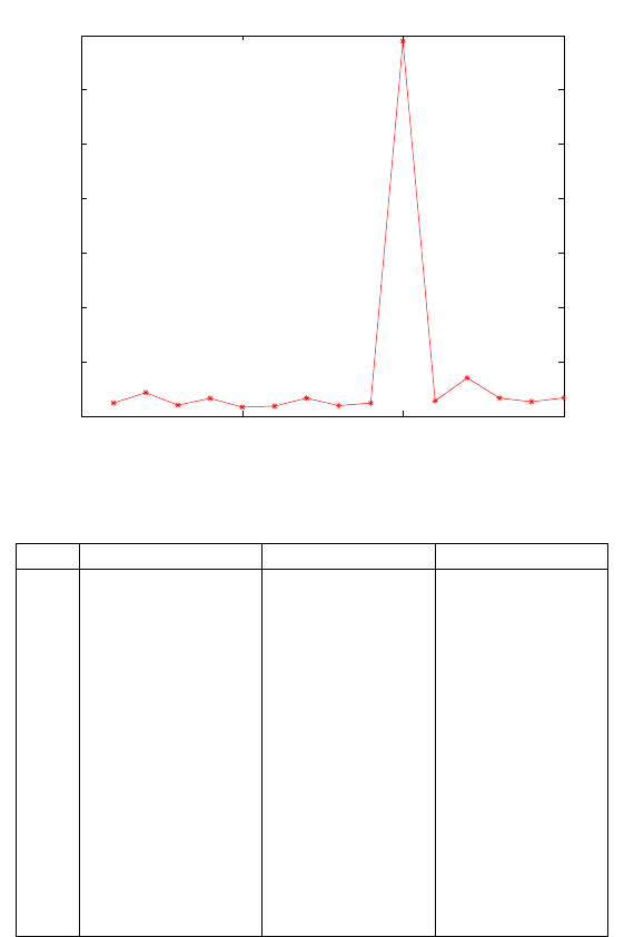
is noticed that the 10th combination had a poor geometry, a fact validated by
the plot of the PDOP values versus the combination numbers in Fig. 12.4. Using
Gauss-Jacobi combinatorial algorithm, this weaker geometry is accounted for dur-
ing the adjustment process. Variance-covariance matrix computed through nonlin-
ear error propagation for that respective set is used. Groebner basis or polynomial
resultants are used as computing engine (see Fig. 7.5 on p. 98) to compute the
minimal combinatorial set as discussed in Sect. 7-331. The computed coefficients
are presented in Table 12.4.

182 12 Positioning by ranging
From the computed coefficients in Table 12.4, the 10th combination is once
again identified as having significantly different values from the rest. This fact
highlights the power of the Gauss-Jacobi combinatorial algorithm in identifying
poor geometry. Using the coefficients of Table 12.4, the solution of receiver position
{X, Y, Z} and the range bias {cdt} for each minimal combinatorial set is carried
out as discussed in Sect. 12-2. The results are presented in Table 12.5. The final
adjusted position is obtained using linear Gauss-Markov model (7.12) on p. 87.
The random pseudo-observation values of Table 12.5 are placed in the vector of
observation y and the dispersion matrix Σ obtained by nonlinear error propagation
using (7.33) on p. 94. The coefficients of the unknowns {X, Y, Z, cdt} form the
design matrix A. The dispersion of the estimated parameters are then obtained
from (7.13).
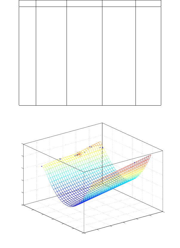
Figure 12.9 gives the plot of the scatter of the 15 combinatorial solutions (shown
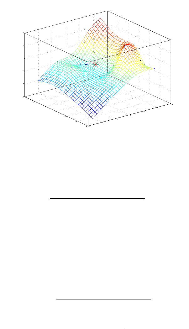
by points) around the adjusted value (indicated by a star). Figure 12.10 is a
magnification of Fig. 12.9 for the scatter of 14 solutions (shown by points) that
are very close to the adjusted value (indicated by a star). The outlying point in
Fig. 12.9 is ignored.
Table 12.2. Geocentric coordinates of six GPS satellites and pseudo-range observations
P RN x
i
= a
i
y
i
= b
i
z
i
= c
i
d
i
23 14177553.47 -18814768.09 12243866.38 21119278.32
9 15097199.81 -4636088.67 21326706.55 22527064.18
5 23460342.33 -9433518.58 8174941.25 23674159.88
1 -8206488.95 -18217989.14 17605231.99 20951647.38
21 1399988.07 -17563734.90 19705591.18 20155401.42
17 6995655.48 -23537808.26 -9927906.48 24222110.91
Table 12.3. Possible combinations and the computed PDOP
Combination Number Combination Computed PDOP
1 23-9-5-1 4.8
2 23-9-5-21 8.6
3 23-9-5-17 4.0
4 23-9-1-21 6.5
5 23-9-1-17 3.3
6 23-9-21-17 3.6
7 23-5-1-21 6.6
8 23-5-1-17 6.6
9 23-5-21-17 4.8
10 23-1-21-17 137.8
11 9-5-1-21 5.6
12 9-5-1-17 14.0
13 9-5-21-17 6.6
14 9-1-21-17 5.2
15 5-1-21-17 6.6
12-2 Ranging by global navigation satellite system (GNSS) 183
0 5 10 15
0
20
40
60
80
100
120
140
Plot of Position Dilution of Precision against combinatorial No.
Combinatorial No.
PDOP
Figure 12.4. A plot of PDOP for respective combinations
Table 12.4. Computed coefficients of the combinations
C/No. c
2
c
1
c
0
1 -0.914220949236445 52374122.9848733 49022682.3125
2 -0.934176403102736 50396827.4998945 7915541824.84375
3 -0.921130625833683 51741826.0147786 343282824.25
4 -0.865060899130107 54950460.2842167 -10201105114.5
5 -0.922335616484969 51877166.0451888 280298481.625
6 -0.919296962706157 51562232.9601199 1354267366.4375
7 -0.894980063579044 53302005.6927825 -3642644147.5625
8 -0.917233949644576 52194946.1124139 132408747.46875
9 -0.925853049262193 51140847.6331213 3726719112.1875
10 3369.83293928593 -1792713339.80277 6251615074927.06
11 -0.877892756651551 54023883.5656926 -6514735288.13762
12 -0.942581538318523 50793361.5303674 784684294.241371
13 -0.908215141659006 52246642.0794924 -2499054749.05572
14 -0.883364070549387 53566554.3869961 -5481411035.37882
15 -0.866750765656126 54380648.2092251 -7320871488.80859
184 12 Positioning by ranging
Table 12.5. Computed combinatorial solution points in a polyhedron
C/No. X(m) Y (m) Z(m) cdt(m)
1 596925.3485 -4847817.3618 4088206.7822 -0.9360
2 596790.3124 -4847765.7637 4088115.7092 -157.0638
3 596920.4198 -4847815.4785 4088203.4581 -6.6345
4 596972.8261 -4847933.4365 4088412.0909 185.6424
5 596924.2118 -4847814.5827 4088201.8667 -5.4031
6 596859.9715 -4847829.7585 4088228.8277 -26.2647
7 596973.5779 -4847762.4719 4088399.8670 68.3398
8 596924.2341 -4847818.6302 4088202.3205 -2.5368
9 596858.7650 -4847764.5341 4088221.8468 -72.8716
10 596951.5275 -4852779.5675 4088758.6420 3510.4002
11 597004.7562 -4847965.2225 4088300.6135 120.5901
12 596915.8657 -4847799.7045 4088195.5770 -15.4486
13 596948.5619 -4847912.9549 4088252.1599 47.8319
14 597013.7194 -4847974.1452 4088269.3206 102.3292
15 597013.1300 -4848019.6766 4088273.9565 134.6230
6750
6800
6850
6900
6950
7000
7050
−1.3
−1.2
−1.1
−1
−0.9
−0.8
−0.7
x 10
4
−1500
−1000
−500
0
500
1000
(X+590000)m
3d−plot of the scatter of the 15−combinatorial solutions around the adjusted value
(Y−4840000)m
(Z+4088000)m
Figure 12.5. Scatter of the 15 combinatorial solutions (•) around the adjusted value
(?)
12-2 Ranging by global navigation satellite system (GNSS) 185
6750
6800
6850
6900
6950
7000
7050
−8050
−8000
−7950
−7900
−7850
−7800
−7750
0
100
200
300
400
500
(X+590000)m
3d−plot of the scatter of the 14−combinatorial solutions around the adjusted value
(Y−4840000)m
(Z+4088000)m
Figure 12.6. Magnification of the scatter of 14 solutions (•) around the adjusted value
(?) of Fig. 12.9
12-221 Extended Newton-Raphson solution
The distance of the receiver from the i-th satellite, the pseudo- range observation,
d
i
is related to the unknown position of the receiver, {x
1
, x
2
, x
3
},
d
i
=
q
(x
1
− a
i
)
2
+ (x
2
− b
i
)
2
+ (x
3
− c
i
)
2
+ x
4
(12.14)
where {a
i
, b
i
, c
i
}, i = 1, . . . , m are the coordinates of the i-th satellite. The distance
is influenced also by the satellite and receiver’ clock biases. The satellite clock
biases can be modelled while the receiver’ clock biases have to be considered as an
unknown variable, x
4
. This means, we have four unknowns, consequently we need
four satellite signals as minimum observation. The general form of the equation
for the i-th satellite is
f
i
= (x
1
− a
i
)
2
+ (x
2
− b
i
)
2
+ (x
3
− c
i
)
2
− (x
4
− d
i
)
2
(12.15)
The residual of this type of equation represents the error implicitly. However in
geodesy the explicit distance error definition is usual, namely,
g
i
= d
i
−
q
(x
1
− a
i
)
2
+ (x
2
− b
i
)
2
+ (x
3
− c
i
)
2
− x
4
(12.16)
The relation between the two expressions,
g
i
= d
i
−
q
f
i
+ (x
4
− d
i
)
2
− x
4
(12.17)

186 12 Positioning by ranging
which implies that if f
i
= 0 then g
i
= 0 and vice versa. Therefore, in case of four
observations, determined system, we employ the first expression, which is easy
to handle as a polynomial. In case of m > 4 satellites, the two representations
the pseudo- range observation models will be not equivalent in least square sense,
namely
min
x
1
,x
2
,x
3
,x
4
m
X
i=1
f
i
6= m in
x
1
,x
2
,x
3
,x
4
m
X
i=1
g
2
i
(12.18)
Let us consider m = 6 satellites of Table 12.2. The numerical equations of the
overdetermined system is given by
g
0
= 2.11193 × 10
7
−
q
(−1.41776 ×10
7
+ x
1
)
2
+ (1.88148 × 10
7
+ x
2
)
2
+ (−1.22439 × 10
7
+ x
3
)
2
− x
4
= 0
g
1
= 2.25271 × 10
7
−
q
(−1.50972 ×10
7
+ x
1
)
2
+ (4.63609 × 10
6
+ x
2
)
2
+ (−2.13267 × 10
7
+ x
3
)
2
− x
4
= 0
g
2
= 2.36742 × 10
7
−
q
(−2.34603 ×10
7
+ x
1
)
2
+ (9.43352 × 10
6
+ x
2
)
2
+ (−8.17494 × 10
6
+ x
3
)
2
− x
4
= 0
g
3
= 2.09516 ×10
7
−
q
(8.20649 ×10
6
+ x
1
)
2
+ (1.8218 × 10
7
+ x
2
)
2
+ (−1.76052 × 10
7
+ x
3
)
2
− x
4
= 0
g
4
= 2.01554 × 10
7
−
q
(−1.39999 ×10
6
+ x
1
)
2
+ (1.75637 × 10
7
+ x
2
)
2
+ (−1.97056 × 10
7
+ x
3
)
2
− x
4
= 0
g
5
= 2.42221 ×10
7
−
q
(−6.99566 ×10
6
+ x
1
)
2
+ (2.35378 × 10
7
+ x
2
)
2
+ (9.92791 × 10
6
+ x
3
)
2
− x
4
= 0
(12.19)
Now, we solve the original system employing one of the solutions of the Gauss-
Jacobi subset solution as initial guess. Let us use the worst one, the 10
th
solution
in Table 12.5, i.e.,
x
1
= 596951.52753,
x
2
= −4.8527795710 × 10
6
,
x
3
= 4.08875864269 × 10
6
,
x
4
= 3510.4002370.
(12.20)
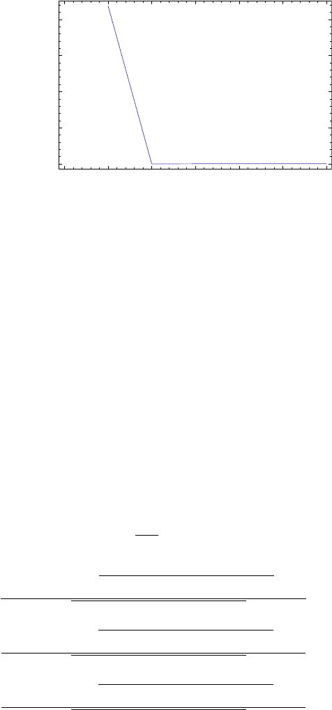
Employing Extended Newton-Raphson method, the convergence is very fast. Fig.
12.7 shows the absolute error of x
1
in meter as function of the number of iterations.
The solution is
12-2 Ranging by global navigation satellite system (GNSS) 187
0
1
2
3
4
5
6
0
5
10
15
20
N
umber of iteration
s
E
rror of x
1
Figure 12.7. Convergence of the metho d in case of the x
1
co ordinate
x
1
= 596929.65349,
x
2
= −4.8478515526 × 10
6
,
x
3
= 4.0882267957 × 10
6
,
x
4
= 15.518050625.
12-222 Homotopy solution of GPS N-point problem
In GPS positioning pseudoranges (d) are measured, so we should minimize the
error (g) of these measurements (see Eq. (12.16)). Considering the least squares
method, we should minimize the following objective function
W (x
1
, x
2
, x
3
, x
4
) =
n
X
i=1
g
2
i
. (12.21)
This minimization problem can be transformed into a square (determined) set of
nonlinear equations
F
i
=
∂W
∂x
i
(12.22)
namely
F
1
=
n
X
i=1
2 (x
1
− a
i
)
x
4
+
q
(x
1
− a
i
)
2
+ (x
2
− b
i
)
2
+ (x
3
− c
i
)
2
− d
i
q
(x
1
− a
i
)
2
+ (x
2
− b
i
)
2
+ (x
3
− c
i
)
2
(12.23)
F
2
=
n
X
i=1
2 (x
2
− b
i
)
x
4
+
q
(x
1
− a
i
)
2
+ (x
2
− b
i
)
2
+ (x
3
− c
i
)
2
− d
i
q
(x
1
− a
i
)
2
+ (x
2
− b
i
)
2
+ (x
3
− c
i
)
2
(12.24)
F
3
=
n
X
i=1
2 (x
3
− c
i
)
x
4
+
q
(x
1
− a
i
)
2
+ (x
2
− b
i
)
2
+ (x
3
− c
i
)
2
− d
i
q
(x
1
− a
i
)
2
+ (x
2
− b
i
)
2
+ (x
3
− c
i
)
2
(12.25)

188 12 Positioning by ranging
F
4
=
n
X
i=1
2
x
4
+
q
(x
1
− a
i
)
2
+ (x
2
− b
i
)
2
+ (x
3
− c
i
)
2
− d
i
(12.26)
For numerical illustration, GPS satellites positions and pseudo-range observations
to six satellites in Table 12.2 are used [41]. To solve this nonlinear system with a
local method, we need proper initial values. Let us consider the 4 point solution of
satellites (23-1-21-17), computed with symbolic-numeric method, as initial values,
(i.e., the 10th solution in Table 12.5) in Table 12.6.
Table 12.6. Solution of GPS 4 point problem computed by symbolic-numeric method
˜x
1
= 596 951.528
˜x
2
= -4 852 779.568
˜x
3
= 4 088 758.642
˜x
4
= 3 510.400
These four satellites have a very poor geometry with a Position Dilution of
Precision (PDOP) value of 137.8 (a good geometry is indicated by a PDOP value
of less than 6). Unfortunately standard Newton-Raphson did not work with these
initial values, the line search decreased the specified step size and was unable to
find a sufficient decrease in the merit function thereby failing to converge.
In order to ensure convergency for this initial values, we can employ fixed point
homotopy, see Section 6-421. Now the start system is
G =
x
1
x
2
x
3
x
4
−
˜x
1
˜x
2
˜x
3
˜x
4
(12.27)
Then to avoid singularity of the homotopy function, (see [320]), le t
γ = i{1, 1, 1, 1}; (12.28)
The homotopy function is the linear combination of the target system, Eq.(12.23)
- Eq.(12.26) and the start system, Eq.(12.27),
H(x
1
, x
2
, x
3
, x
4
, λ) = γ(1 −λ)
G
1
G
2
G
3
G
4
+ λ
F
1
F
2
F
3
F
4
(12.29)
and the corresponding system of the differential equations
d
dλ
x
1
(λ)
x
2
(λ)
x
3
(λ)
x
4
(λ)
= −H
x
−1
H
λ
(12.30)
where the Jacobian

12-2 Ranging by global navigation satellite system (GNSS) 189
(H
x
)
i,j
= γ(1 − λ)
∂G
i
∂x
j
i,j
+ λ
∂F
i
∂x
j
i,j
(12.31)
and
(H
λ
)
i
= F
i
(x
1
, x
2
, x
3
, x
4
) − γG
i
(x
1
, x
2
, x
3
, x
4
) (12.32)
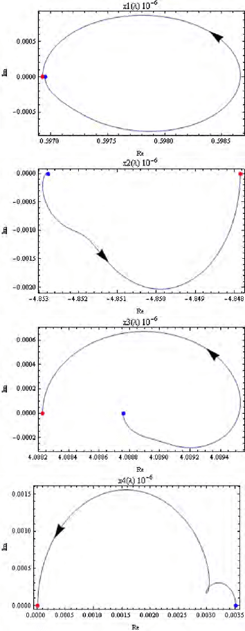
Now employing path tracing by integration with computing inverse, we get 3
solutions, but only one of them is the physically acceptable solution, see [41, 318].
Table 12.7. shows the values of this solution.
Table 12.7. Solution of the GPS N-point problem
x
1
= 596 929.653
x
2
= -4 847 851.552
x
3
= 4 088 226.795
x
4
= 15.518
The trajectories belonging to this solution can be seen in Fig. 12.8.
12-223 Least squares versus Gauss-Jacobi combinatorial
Let us now compare the least squares solution and the Gauss-Jacobi combinatorial
approach. Using the combinatorial approach, the stationary receiver position and
range bias are computed as discussed in Sect. 12-22. For the least squares approach,
the nonlinear observation equations (12.2) are first linearized using Taylor series
expansion for the 6 satellites in Table 12.2. This linearization process generates the
Jacobi matrix required by the approach. After linearization, the desired values are
estimated iteratively using linear models. As approximate starting values for the
iterations, let us assign the stationary receiver position and the stationary receiver
range bias zero values. Let us also set a convergence limit of 1×10
−8
, as the differ-
ence between values of two successive iterations. With these settings, 6 iterations
are required for the threshold condition above to be achieved. In the second case,
the values of the combinatorial algorithm are used as approximate starting values
for least squares solution. This time round, only two iterations were required to
achieve convergence. For users who prefer least squares approach, Gauss-Jacobi
combinatorial algorithm can therefore be used to offer quick approximate starting
values that lead to faster convergence.
From (12.2) on p. 176, and the results of both procedures, residuals are com-
puted, squared and used to compute the error norm from
norm =
v
u
u
t
(
6
X
i=1
d
i
− [
q
(
ˆ
X − a
i
)
2
+ (
ˆ
Y − b
i
)
2
+ (
ˆ
Z − c
i
)
2
− ˆx
4
]
2
)
. (12.33)
In (12.33), {
ˆ
X,
ˆ
Y ,
ˆ
Z, ˆx
4
} are the computed values of the stationary receiver posi-
tion and range bias. The entities {a
i
, b
i
, c
i
} | ∀i = {1, . . ., 6} are the coordinates
of the six satellites in Table 12.2 and {d
i
} | ∀i = {1, . . ., 6} the measured pseudo-
ranges.
190 12 Positioning by ranging
Figure 12.8. Homotopy solution paths of the GPS positioning problem
