Awange J.,Grafarend E., Palancz B., Zaletnyik P. Algebraic Geodesy and Geoinformatics
Подождите немного. Документ загружается.


170 11 Cartesian to ellipsoidal mapping
Table 11.5. Ellipsoidal Cartesian coordinates (x
1
, x
2
, x
3
) and Lagrange multiplier x
4
Station x
1
(m) x
2
(m) x
3
(m) x
4
(m
−2
)
Borkum (Ger) 3770641.3815 446073.3407 5107649.9100 1.746947e-019
Degerby (Fin) 2994054.5862 1112555.2111 5502222.2279 8.554612e-020
Furuoegrund (Swe) 2527009.7166 981952.1770 5753910.8356 1.288336e-019
Hamina (Fin) 2795463.7019 1435423.9394 5531667.2524 6.643801e-020
Hanko (Fin) 2959199.2560 1254674.1532 5490572.5584 9.797001e-020
Helgoland (Ger) 3706019.4100 513709.6757 5148157.7376 1.705084e-019
Helsinki (Fin) 2885126.2764 1342705.0575 5509017.7534 9.533532e-020
Kemi (Fin) 2397061.6153 1093325.7692 5789084.2263 1.028464e-019
Klagshamn (Swe) 3527564.6083 807509.0510 5234518.0924 1.484413e-019
Klaip eda (Lit) 3353562.2593 1302052.1493 5249115.3164 2.065021e-019
List/Sylt (Ger) 3625314.3442 537850.0757 5202502.0726 1.746017e-019
Molas (Lit) 3358777.7367 1294901.3835 5247559.7944 1.152676e-019
M¨antyluoto (Fin) 2831087.1439 1113098.9988 5587146.0214 8.370165e-020
Raahe (Fin) 2494026.5401 1131367.1449 5740935.7483 8.418639e-020
Ratan (Swe) 2620078.1000 1000004.6329 5709301.7015 8.988111e-020
Spikarna (Swe) 2828561.2473 893619.8693 5627422.6007 1.068837e-019
Sto ckholm (Swe) 3100991.6259 1013015.4066 5462342.8173 1.375524e-019
Ustka (Pol) 3544995.3045 1073934.0083 5174921.9867 1.328158e-019
Vaasa (Fin) 2691299.0138 1063688.2670 5664788.9183 7.577249e-020
Visby (Swe) 3249290.3945 1073620.2512 5364339.7330 1.069551e-019
OElands N. U. (Swe) 3295535.1675 1012559.8663 5348086.8692 1.231803e-019
Table 11.6. Geodetic computed from ellipsoidal Cartesian coordinates in closed form
Station Longitude L Latitude B Ellipsoidal height H
◦ 0 00 ◦ 0 00
m
Borkum (Ger) 6 44 48.5914 53 33 27.4808 45.122
Degerby (Fin) 20 23 4.0906 60 1 52.8558 22.103
Furuoegrund (Swe) 21 14 6.9490 64 55 10.2131 33.296
Hamina (Fin) 27 10 47.0690 60 33 52.9819 17.167
Hanko (Fin) 22 58 35.4445 59 49 21.6459 25.313
Helgoland (Ger) 7 53 30.3480 54 10 29.3979 44.042
Helsinki (Fin) 24 57 24.2446 60 9 13.2416 24.633
Kemi (Fin) 24 31 5.6737 65 40 27.7029 26.581
Klagshamn (Swe) 12 53 37.1597 55 31 20.3311 38.345
Klaip eda (Lit) 21 13 9.0156 55 45 16.5952 53.344
List/Sylt (Ger) 8 26 19.7594 55 1 3.0992 45.101
Molas (Lit) 21 4 58.8931 55 43 47.2453 29.776
M¨antyluoto (Fin) 21 27 47.7777 61 35 39.3552 21.628
Raahe (Fin) 24 24 1.8197 64 38 46.8352 21.757
Ratan (Swe) 20 53 25.2392 63 59 29.5936 23.228
Spikarna (Swe) 17 31 57.9060 62 21 48.7645 27.620
Sto ckholm (Swe) 18 5 27.2528 59 19 20.4054 35.539
Ustka (Pol) 16 51 13.8751 54 35 15.6866 34.307
Vaasa (Fin) 21 33 55.9146 63 5 42.8394 19.581
Visby (Swe) 18 17 3.9292 57 38 21.3487 27.632
OElands N. U. (Swe) 17 4 46.8542 57 22 3.4508 31.823
11-5 Concluding remarks 171
11-5 Concluding remarks
The chapter has presented a new and direct algebraic approach to the mapping
problem that has attracted a lot of research as evidenced in Table 11.1. All that
is required is for the user to apply equations (11.26) and (11.27). Probably the
best choice is the Grafarend-Lohse’s method, but Linear Homotopy as a global
numerical solver and the Extended Newton-Raphson can also be good candidates.
These techniques work well out of the Mathematica, too.

12 Positioning by ranging
12-1 Applications of distances
Throughout history, position determination has been one of the fundamental task
undertaken by man on daily basis. Each day, one has to know where one is, and
where one is going. To mountaineers, pilots, sailors etc., the knowledge of position
is of great importance. The traditional way of locating one’s position has been
the use of maps or campus to determine directions. In modern times, the entry
into the game by Global Navigation Satellite Systems GNSS that comprise the
Global Positioning System (GPS), Russian based GLONASS and the proposed
Europ ean’s GALILEO have revolutionized the art of positioning.
In the new field of GPS meteorology for example, as well as geodesy, robotics
and geoinformatics etc., distances (ranges) play a key role in determining unknown
parameters. In the recently developed Spatial Reference System
1
designed to check
and control the accuracy of three-dimensional coordinate measuring machines and
tooling equipments, coordinates of the edges of the instrument are computed from
distances of the bars. This signifies that industrial application of distances is fast
gaining momentum just as in geosciences. In GPS meteorology that we will discuss
in Chap. 15 for example, distances trave led by GPS satellites signals through the
atmosphere are measured and related do the would be distances in vacuo (i.e.,
in the absence of the atmosphere). Since these signals traverse the atmosphere,
they enable accurate global remote sensing of the atmosphere to retrieve vertical
profiles of temperature, pressure and water vapour .
Apart from distances being used to determine the user’s position and its appli-
cation in GPS meteorology, they find use in quick station search in engineering and
cadastral surveying operations. Ranging, together with resection and intersection
techniques (see e.g., Chaps. 13 and 14) are useful in densifying geodetic networks
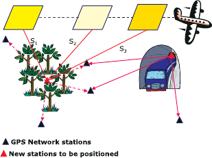
as illustrated by Fig. 12.1. Densification is vital for extending network control in
areas where GPS receivers fail, e.g., in tunnels and forests (see Fig. 12.1). Distances
are also used in photogrammetry to determine the perspective center coordinates
from measured photo and the ground coordinates. Another area of application is
in robotics.
Measured distances (ranges) are normally related to the desired parameters
via nonlinear systems of equations that require explicit/exact solutions. Approx-
imate numerical procedures used for solving such nonlinear distance equations
are normally iterative in nature, and often require linearization of the nonlinear
equations. Where closed form solutions exist, they require differencing and substi-
tution steps which are laborious and time consuming. The desire therefore is to
have procedures that can offer direct solutions without linearization, iterations or
substitutional steps.
In this chapter, direct procedures for solving nonlinear systems of equations
for distances without linearization, iteration, forward and backward substitutions
1
Metronom US., Inc., Ann Arbor: http://www.metronomus.com
J.L. Awange et al., Algebraic Geodesy and Geoinformatics, 2nd ed.,
DOI 10.1007/978-3-642-12124-1 12,
c
Springer-Verlag Berlin Heidelberg 2010
174 12 Positioning by ranging
are presented. In particular, the advantages of fast computers with large storage
capacities, and computer algebraic software of Mathematica, Maple and Matlab are
exploited by the algebraic based approaches. These methods which were presented
in Chaps. 4, 5 and 7 directly deliver the position of unknown station from distance
measurements. They do so by eliminating variables appearing in the nonlinear
systems of equations resulting in univariate polynomials that are solvable using
Matlab’s “roots” command.
The improvements made on measuring instruments has led to Electromagnetic
Distance Measuring (EDM) equipments that measure distances to higher accu-
racies. By measuring distances from an unknown station to two known stations,
two nonlinear distance equations, whose geometrical properties have been stud-
ied by [178, 179] are formed. They have to be solved for the planar position of
the unknown station. If distances are measured from an unknown station to three
known stations instead, three nonlinear distance equations have to be solved for
the unknown position. In Chaps. 4 and 7, planar distances were encountered in
Figs. 4.1 and 7.2 respectively, where they were used to illustrate the concepts that
were discussed. The position {x
0
, y
0
} of the unknown station P
0
was related to
the measured distances by (4.1) and (4.2) on p. 33.
The term ranging is broadly used in this chapter to incorporate the GPS
pseudo-range measurements. For Local Positioning Systems (e.g., using EDMs),
distances can be measured directly. For Global Positioning System (GPS) how-
ever, distances are not directly measured owing to satellites and receivers’ clock
uncertainties.
Figure 12.1. Point densification in forest and inside a tunnel
12-2 Ranging by global navigation satellite system (GNSS)
12-21 The pseudo-ranging four-points problem
If one has access to a hand held GPS receiver, a mobile phone or a watch fitted
with a GPS receiver, one needs only to press the button to know the position where
one is standing. Basically, the operations involve distance measurements to GPS
satellites whose properties were discussed in Sect. 10-3. The receiver measures the
12-2 Ranging by global navigation satellite system (GNSS) 175
travel time of the signal transmitted from the satellites. This distance is calculated
from the relationship
distance = velocity × time,
where velocity is given by the speed of light in vacuum. The distances S
i
are then
related to the position of the unknown station {X
0
, Y
0
, Z
0
} by
S
i
=
p
(X
i
− X
0
)
2
+ (Y
i
− Y
0
)
2
+ (Z
i
− Z
0
)
2
, (12.1)
where {X
i
, Y
i
, Z
i
} are the position of the satellite i. Geometrically, the three
unknowns {X
0
, Y
0
, Z
0
} are obtained from the intersection of three spherical cones
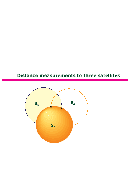
given by the pseudo-ranging equations. Distance measurements to only one satellite
puts the user’s position anywhere within the sphere formed by distance S
1
in Fig.
12.2. Measurements to two satellites narrow the position to the intersection of the
two spheres S
1
and S
2
. 12.2. A third satellite is therefore required to definitely fix
the user’s position. This is achieved by the intersection of the third sphere S
3
with
the other two.
Figure 12.2. Pseudo-ranging geometry
If direct distance measurements to the satellites were possible, (12.1) would
have sufficed to provide the user’s location. Distance measurements to satellites as
already stated are however not direct owing to the satellites and receivers’ c lock bi-
ases. Satellites’ clock biases can be modelled while the receivers’ clock biases have
to be determined as an unknowns. For GPS positioning therefore, in addition to
position determination from measured distances, the receiver’s clock bias has to be
added in the observation equations as unknown. Since distances to the satellites in
(12.1) are derived from the transmitted signals that are affected by b oth satellites
and receivers’ clock uncertainties, they are normally referred to as pse udo-ranges.
What one measures therefore are not the actual distances (ranges) but pseudo-
ranges. Pseudo-range measurements lead to GPS pseudo-ranging four-points prob-
lem (“pseudo 4P4”), which is the problem of determining the four unknowns. The
unknowns comprise the three components of receiver position {X
0
, Y
0
, Z
0
} and
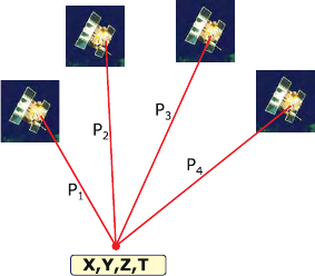
the stationary receiver range bias. Minimum observations required to obtain re-
ceiver position and range bias are pseudo-range observations to four satellites as
depicted in Fig. 12.3. Besides pseudo-range observations, phase measurements are
often used where accurate results are desired.
176 12 Positioning by ranging
Figure 12.3. Point positioning using GPS satellites
Four pseudo-range equations are formed from (12.1) and expressed alge-
braically as
(x
1
− a
0
)
2
+ (x
2
− b
0
)
2
+ (x
3
− c
0
)
2
− (x
4
− d
0
)
2
= 0
(x
1
− a
1
)
2
+ (x
2
− b
1
)
2
+ (x
3
− c
1
)
2
− (x
4
− d
1
)
2
= 0
(x
1
− a
2
)
2
+ (x
2
− b
2
)
2
+ (x
3
− c
2
)
2
− (x
4
− d
2
)
2
= 0
(x
1
− a
3
)
2
+ (x
2
− b
3
)
2
+ (x
3
− c
3
)
2
− (x
4
− d
3
)
2
= 0
where x
1
, x
2
, x
3
, x
4
∈
(a
0
, b
0
, c
0
) = (x
0
, y
0
, z
0
) ∼ P
0
(a
1
, b
1
, c
1
) = (x
1
, y
1
, z
1
) ∼ P
1
(a
2
, b
2
, c
2
) = (x
2
, y
2
, z
2
) ∼ P
2
(a
3
, b
3
, c
3
) = (x
3
, y
3
, z
3
) ∼ P
3
.
(12.2)
In (12.2),
P
0
, P
1
, P
2
, P
3
are the positions of the four GPS satellites whose sig-
nals are tracke d by the receiver at an unknown station P
0
. The satellites’ positions
are given by the coordinates {x
i
, y
i
, z
i
|i = 0, 1, 2, 3}, where i indicating a particular
satellite numb e r. The measured pseudo-ranges to these satellites from a stationary
receiver at P
0
are given by {d
0
, d
1
, d
2
, d
3
}. The parameters {a
0
, b
0
, c
0
}, {a
1
, b
1
, c
1
},
{a
2
, b
2
, c
2
}, {a
3
, b
3
, c
3
}, {d
0
, d
1
, d
2
, d
3
} are known elements of the spherical cone
that intersect at P
0
to give the unknown coordinates {x
1
, x
2
, x
3
} of the rece iver and
the stationary receiver range bias x
4
. Several procedures have been put forward to
obtain exact solution of (12.2), e.g., [53, 181, 242, 243, 272, 363]. In what follows, we
present alternative solutions to (12.2) based on algebraic approaches of Groebner
bases and polynomial resultants discussed in Chaps. 4 and 5 respectively. Equation
(12.2) is expanded and arranged in the lexicographic order {x
1
> x
2
> x
3
> x
4
}
as
x
2
1
− 2a
0
x
1
+ x
2
2
− 2b
0
x
2
+ x
2
3
− 2c
0
x
3
− x
2
4
+ 2d
0
x
4
+ a
2
0
+ b
2
0
+ c
2
0
− d
2
0
= 0
x
2
1
− 2a
1
x
1
+ x
2
2
− 2b
1
x
2
+ x
2
3
− 2c
1
x
3
− x
2
4
+ 2d
1
x
4
+ a
2
1
+ b
2
1
+ c
2
1
− d
2
1
= 0
x
2
1
− 2a
2
x
1
+ x
2
2
− 2b
2
x
2
+ x
2
3
− 2c
2
x
3
− x
2
4
+ 2d
2
x
4
+ a
2
2
+ b
2
2
+ c
2
2
− d
2
2
= 0
x
2
1
− 2a
3
x
1
+ x
2
2
− 2b
3
x
2
+ x
2
3
− 2c
3
x
3
− x
2
4
+ 2d
3
x
4
+ a
2
3
+ b
2
3
+ c
2
3
− d
2
3
= 0,
(12.3)
where the unknown variables to be determined are {x
1
, x
2
, x
3
, x
4
}. The other
terms are known constants. Equation (12.3) is written with the linear terms on
the right-hand-side and the nonlinear terms on the left-hand-side as
12-2 Ranging by global navigation satellite system (GNSS) 177
x
2
1
+ x
2
2
+ x
2
3
− x
2
4
= 2a
0
x
1
+ 2b
0
x
2
+ 2c
0
x
3
− 2d
0
x
4
+ d
2
0
− a
2
0
− b
2
0
− c
2
0
x
2
1
+ x
2
2
+ x
2
3
− x
2
4
= 2a
1
x
1
+ 2b
1
x
2
+ 2c
1
x
3
− 2d
1
x
4
+ d
2
1
− a
2
1
− b
2
1
− c
2
1
x
2
1
+ x
2
2
+ x
2
3
− x
2
4
= 2a
2
x
1
+ 2b
2
x
2
+ 2c
2
x
3
− 2d
2
x
4
+ d
2
2
− a
2
2
− b
2
2
− c
2
2
x
2
1
+ x
2
2
+ x
2
3
− x
2
4
= 2a
3
x
1
+ 2b
3
x
2
+ 2c
3
x
3
− 2d
3
x
4
+ d
2
3
− a
2
3
− b
2
3
− c
2
3
.
(12.4)
Subtracting the last expression (12.4iv) from the first three expressions (12.4i),
(12.4ii), and (12.4iii) leads to
a
03
x
1
+ b
03
x
2
+ c
03
x
3
+ d
30
x
4
+ e
03
= 0
a
13
x
1
+ b
13
x
2
+ c
13
x
3
+ d
31
x
4
+ e
13
= 0
a
23
x
1
+ b
23
x
2
+ c
3
x
3
+ d
32
x
4
+ e
23
= 0,
(12.5)
where
a
03
= 2(a
0
− a
3
), b
03
= 2(b
0
− b
3
), c
03
= 2(c
0
− c
3
), d
30
= 2(d
3
− d
0
),
a
13
= 2(a
1
− a
3
), b
13
= 2(b
1
− b
3
), c
13
= 2(c
1
− c
3
), d
31
= 2(d
3
− d
1
),
a
23
= 2(a
2
− a
3
), b
23
= 2(b
2
− b
3
), c
23
= 2(c
2
− c
3
), d
32
= 2(d
3
− d
2
),
e
03
= (d
2
0
− a
2
0
− b
2
0
− c
2
0
) −(d
2
3
− a
2
3
− b
2
3
− c
2
3
),
e
13
= (d
2
1
− a
2
1
− b
2
1
− c
2
1
) −(d
2
3
− a
2
3
− b
2
3
− c
2
3
),
e
23
= (d
2
2
− a
2
2
− b
2
2
− c
2
2
) −(d
2
3
− a
2
3
− b
2
3
− c
2
3
).
We note immediately that (12.5) comprises three equations which are linear with
four unknowns leading to an underdetermined system of equations. This is cir-
cumvented by treating one variable, say x
4
, as a constant thereby leading to a
system of three equations in three unknowns. We then apply either Groebner ba-
sis or polynomial resultants techniques to solve the linear system of equation for
x
1
= g(x
4
), x
2
= g(x
4
), x
3
= g(x
4
), where g(x
4
) is a linear function.
12-211 Sturmfels’ approach
The Sturmfels’ [375] approach discussed in Sect. 5-32 is applied to solve (12.5).
Depending on which variable one wants, (12.5) is rewritten such that this particular
variable is hidden (i.e., is treated as a constant). If our interest is to solve x
1
=
g(x
4
) for instance, (12.5) is first homogenized using x
5
(see Definition 5.1 on p.
49) and then written by hiding x
1
as
f
1
:= (a
03
x
1
+ d
30
x
4
+ e
03
)x
5
+ b
03
x
2
+ c
03
x
3
f
2
:= (a
13
x
1
+ d
31
x
4
+ e
13
)x
5
+ b
13
x
2
+ c
13
x
3
f
3
:= (a
23
x
1
+ d
32
x
4
+ e
13
)x
5
+ b
23
x
2
+ c
23
x
3
.
(12.6)
The Jacobian determinant of (12.6) then becomes
J
x
1
= det
∂f
1
∂x
2
∂f
1
∂x
3
∂f
1
∂x
5
∂f
2
∂x
2
∂f
2
∂x
3
∂f
2
∂x
5
∂f
3
∂x
2
∂f
3
∂x
3
∂f
3
∂x
5
= det
b
03
c
03
(a
03
x
1
+ d
30
x
4
+ e
03
)
b
13
c
13
(a
13
x
1
+ d
31
x
4
+ e
13
)
b
23
c
23
(a
23
x
1
+ d
32
x
4
+ e
23
)
. (12.7)
The determinant obtained in (12.7) gives the expression for x
1
= g(x
4
) as

178 12 Positioning by ranging
x
1
= −(e
03
b
13
c
23
+d
32
x
4
b
03
c
13
+d
30
x
4
b
13
c
23
−d
30
x
4
c
13
b
23
−d
31
x
4
b
03
c
23
−
e
03
c
13
b
23
−e
13
b
03
c
23
+e
13
c
03
b
23
+e
23
b
03
c
13
+d
31
x
4
c
03
b
23
−d
32
x
4
c
03
b
13
−
e
23
c
03
b
13
)/(a
23
c
13
b
03
+ a
13
b
23
c
03
− a
13
c
23
b
03
− a
23
b
13
c
03
− a
03
c
13
b
23
+
a
03
c
23
b
13
).
For x
2
= g(x
4
), we have
f
4
:= (b
03
x
2
+ d
30
x
4
+ e
03
)x
5
+ a
03
x
1
+ c
03
x
3
f
5
:= (b
13
x
2
+ d
31
x
4
+ e
13
)x
5
+ a
13
x
1
+ c
13
x
3
f
6
:= (b
23
x
2
+ d
32
x
4
+ e
23
)x
5
+ a
23
x
1
+ c
23
x
3
,
(12.8)
whose Jacobian determinant is given by
J
x
2
= det
∂f
4
∂x
1
∂f
4
∂x
3
∂f
4
∂x
5
∂f
5
∂x
1
∂f
5
∂x
3
∂f
5
∂x
5
∂f
6
∂x
1
∂f
6
∂x
3
∂f
6
∂x
5
= det
a
03
c
03
(b
03
x
2
+ d
30
x
4
+ e
03
)
a
13
c
13
(b
13
x
2
+ d
31
x
4
+ e
13
)
a
23
c
23
(b
23
x
2
+ d
32
x
4
+ e
23
)
. (12.9)
The determinant obtained in (12.9) gives the expression for x
2
= g(x
4
) as
x
2
= −(a
23
c
13
d
30
x
4
+ a
03
c
23
d
31
x
4
+ a
03
c
23
e
13
− a
23
c
03
d
31
x
4
−
a
03
c
13
d
32
x
4
− a
03
c
13
e
23
+ a
13
c
03
d
32
x
4
− a
13
c
23
d
30
x
4
− a
13
c
23
e
03
−
a
23
c
03
e
13
+ a
23
c
13
e
03
+ a
13
c
03
e
23
)/(a
23
c
13
b
03
+ a
13
b
23
c
03
− a
13
c
23
b
03
−
a
23
b
13
c
03
− a
03
c
13
b
23
+ a
03
c
23
b
13
).
Finally x
3
= g(x
4
) leads to
f
7
:= (c
03
x
3
+ d
30
x
4
+ e
03
)x
5
+ a
03
x
1
+ b
03
x
2
f
8
:= (c
13
x
3
+ d
31
x
4
+ e
13
)x
5
+ a
13
x
1
+ b
13
x
2
f
9
:= (c
23
x
3
+ d
32
x
4
+ e
23
)x
5
+ a
23
x
1
+ b
23
x
2
,
(12.10)
whose Jacobian determinant is given by
J
x
3
= det
∂f
7
∂x
1
∂f
7
∂x
2
∂f
7
∂x
5
∂f
8
∂x
1
∂f
8
∂x
2
∂f
8
∂x
5
∂f
9
∂x
1
∂f
9
∂x
2
∂f
9
∂x
5
= det
a
03
b
03
(c
03
x
3
+ d
30
x
4
+ e
03
)
a
13
b
13
(c
13
x
3
+ d
31
x
4
+ e
13
)
a
23
b
23
(c
23
x
3
+ d
32
x
4
+ e
23
)
. (12.11)
The determinant obtained in (12.7) gives the expression for x
3
= g(x
4
) as
x
3
= −(a
23
b
03
d
31
x
4
+ a
03
b
13
d
32
x
4
+ a
03
b
13
e
23
− a
23
b
13
d
30
x
4
−
a
03
b
23
d
31
x
4
− a
03
b
23
e
13
+ a
13
b
23
d
30
x
4
− a
13
b
03
d
32
x
4
− a
13
b
03
e
23
−
a
23
b
13
e
03
+ a
23
b
03
e
13
+ a
13
b
23
e
03
)/(a
23
b
03
c
13
+ a
13
b
23
c
03
− a
13
b
03
c
23
−
a
23
b
13
c
03
− a
03
b
23
c
13
+ a
03
b
13
c
23
).
12-2 Ranging by global navigation satellite system (GNSS) 179
On substituting the obtained expressions of x
1
= g(x
4
), x
2
= g(x
4
) and x
3
= g(x
4
) in
(12.3i), we obtain a quadratic function in x
4
. The structure of the quadratic equation is
given in [14, Box 3-12, p. 54].
12-212 Groebner basis approach
Using (4.36) on p. 45, the Groebner basis of (12.5) is computed as
GroebnerBasis
{a
03
x
1
+ b
03
x
2
+ c
03
x
3
+ d
30
x
4
+ e
03
,
a
13
x
1
+ b
13
x
2
+ c
13
x
3
+ d
31
x
4
+ e
13
,
a
23
x
1
+ b
23
x
2
+ c
3
x
3
+ d
32
x
4
+ e
23
}, {x
1
, x
2
, x
3
, x
4
}
, (12.12)
leading to Solution 12.1.
Solution 12.1. [Computed Groebner basis for GPS pseudo-ranging equations.]
g
1
:= (−a
23
)b
13
e
03
+a
13
b
23
e
03
+a
23
b
03
e
13
−a
03
b
23
e
13
−a
13
b
03
e
23
+a
03
b
13
e
23
−a
23
b
13
c
03
x
3
+
a
13
b
23
c
03
x
3
+ a
23
b
03
c
13
x
3
− a
03
b
23
c
13
x
3
− a
13
b
03
c
23
x
3
+ a
03
b
13
c
23
x
3
− a
23
b
13
d
30
x
4
+
a
13
b
23
d
30
x
4
+ a
23
b
03
d
31
x
4
− a
03
b
23
d
31
x
4
− a
13
b
03
d
32
x
4
+ a
03
b
13
d
32
x
4
.
g
2
:= (−a
23
)e
13
+a
13
e
23
−a
23
b
13
x
2
+a
13
b
23
x
2
−a
23
c
13
x
3
+a
13
c
23
x
3
−a
23
d
31
x
4
+a
13
d
32
x
4
.
g
3
:= (−a
23
)e
03
+a
03
e
23
−a
23
b
03
x
2
+a
03
b
23
x
2
−a
23
c
03
x
3
+a
03
c
23
x
3
−a
23
d
30
x
4
+a
03
d
32
x
4
.
g
4
:= (−a
13
)e
03
+a
03
e
13
−a
13
b
03
x
2
+a
03
b
13
x
2
−a
13
c
03
x
3
+a
03
c
13
x
3
−a
13
d
30
x
4
+a
03
d
31
x
4
.
g
5
:= e
23
+ a
23
x
1
+ b
23
x
2
+ c
23
x
3
+ d
32
x
4
.
g
6
:= e
13
+ a
13
x
1
+ b
13
x
2
+ c
13
x
3
+ d
31
x
4
.
g
7
:= e
03
+ a
03
x
1
+ b
03
x
2
+ c
03
x
3
+ d
30
x
4
.
From Solution 12.1, one notes that g
1
is a p olynomial in the variables x
3
and
x
4
. With g
1
expressed as x
3
= g(x
4
), it is substituted in g
2
to obtain x
2
= g(x
4
),
which together with x
3
= g(x
4
) are substituted in g
5
to give x
1
= g(x
4
). On
substituting the obtained express ions of x
1
= g(x
4
), x
2
= g(x
4
) and x
3
= g(x
4
) in
(12.3i), a quadratic equation in x
4
(i.e., h
2
x
2
4
+ h
1
x
4
+ h
0
= 0) is obtained. The
coefficients are as given in [14, Box 3-14, p. 55]. The desired variables x
1
= g(x
4
),
x
2
= g(x
4
) and x
3
= g(x
4
) could also be obtained directly using the reduced
Groebner basis (4.38) on p. 45. If one desired x
3
= g(x
4
) for example, (12.12)
could be formulated as
GroebnerBasis
{a
03
x
1
+ b
03
x
2
+ c
03
x
3
+ d
30
x
4
+ e
03
,
a
13
x
1
+ b
13
x
2
+ c
13
x
3
+ d
31
x
4
+ e
13
,
a
23
x
1
+ b
23
x
2
+ c
3
x
3
+ d
32
x
4
+ e
23
}, {x
1
, x
2
, x
3
, x
4
},
{x
1
, x
2
, x
4
}
,
(12.13)
giving only the value of g
1
in Solution 12.1. This is repeated for x
1
= g(x
4
) and
x
2
= g(x
4
). The algorithms for solving the unknown value x
4
of the receiver range
bias from the quadratic equation {h
2
x
2
4
+ h
1
x
4
+ h
0
= 0} and the respective
stationary receiver coordinates are;
• Awange-Grafarend Groebner basis algorithm and,
• Awange-Grafarend Multipolynomial resultants algorithm.

180 12 Positioning by ranging
They can be accessed in the GPS toolbox
2
and are discussed in detail in [24]. The
distinction between the polynomial resultants method and the approach proposed
by [181] is that the former does not have to invert the coefficient matrix. It instead
uses the necessary and sufficient conditions requiring the determinant to vanish if
the four equations have a nontrivial solution. With the coefficients h
1
, h
2
and h
3
,
the value of x
4
could also be s olved from (3.8) or (3.9) on p. 24. Let us consider
the example in [181, 242].
Example 12.1 (Ranging to four satellites). From the coordinates of four GPS satel-
lites given in Table 12.1, we apply the Awange-Grafarend algorithms listed above
to compute coordinates of a stationary GPS receiver and the receiver range bias
term. tiny
Table 12.1. Geocentric coordinates of four GPS satellites and the pseudo-range obser-
vations
i x
i
= a
i
y
i
= b
i
z
i
= c
i
d
i
0 1.483230866e+7 -2.046671589e+7 -7.42863475e+6 2.4310764064e+7
1 -1.579985405e+7 -1.330112917e+7 1.713383824e+7 2.2914600784e+7
2 1.98481891e+6 -1.186767296e+7 2.371692013e+7 2.0628809405e+7
3 -1.248027319e+7 -2.338256053e+7 3.27847268e+6 2.3422377972e+7
The computed coefficients using either of the algorithms are:
h
2
= −9.104704113943708e − 1
h
1
= 5.233385578536521e7
h
0
= −5.233405293375e9.
Once these coefficients have been computed, the algorithms proceed to solve
the roots x
4
of the quadratic equation {h
2
x
2
4
+ h
1
x
4
+ h
0
= 0} giving the
stationary receiver range bias term. The admissible value of the stationary re-
ceiver range bias term is then substituted in the expressions x
1
= g(x
4
), x
2
=
g(x
4
), x
3
= g(x
4
) in Solution 12.1 to give the values of stationary receiver coor-
dinates {x
1
= X, x
2
= Y, x
3
= Z} respectively. With x
−
4
=-57479918.164 m or x
+
4
=-100.0006 m, the complete pair of solutions with units in meters are
X = −2892123.412, Y = 7568784.349, Z = −7209505.102
x
−
4
or X = 1111590.460, Y = −4348258.631, Z = 4527351.820
x
+
4
The results indicate that the solution space is non unique. In-order to decide
on the admissible solution from the pair above, we compute the norm (radial
distance from the center of the Earth) of the positional vector {X, Y, Z}
x
−
4
and
{X, Y, Z}
x
+
4
using
norm =
p
(X
2
+ Y
2
+ Z
2
).
If the receiver coordinates are in the global reference frame (see Sect. 10-3), the
norm of the positional vector of the receiver station will approximate the value
2
http://www.ngs.noaa.gov/gps-toolbox/awange.htm
