Van Kreveld M., Nievergelt J., Roos T., Widmayer P. (eds.) Algorithmic Foundations of Geographic Information Systems
Подождите немного. Документ загружается.

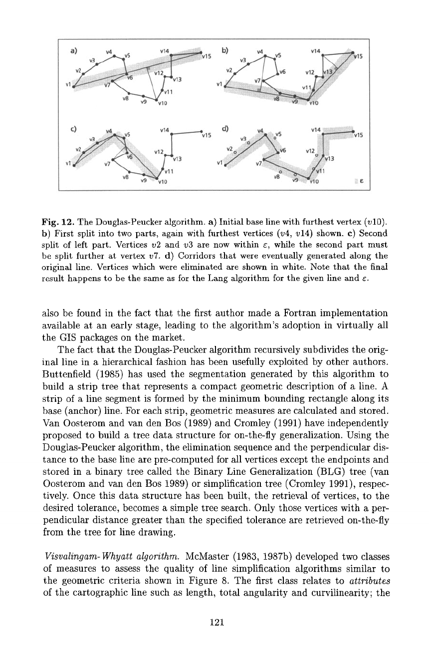
C) v14 T~Vl 5
v2 ...... I
v8 ~--'~'~ vlO
Fig. 12. The Douglas-Peucker algorithm, a) InitiM base line with furthest vertex (vl0).
b) First split into two parts, again with furthest vertices (v4, v14) shown, c) Second
split of left part. Vertices v2 and v3 are now within s, while the second part must
be split further at vertex v7. d) Corridors that were eventually generated along the
originM line. Vertices which were eliminated are shown in white. Note that the final
result happens to be the same as for the Lang algorithm for the given line and s.
also be found in the fact that the first author made a Fortran implementation
available at an early stage, leading to the algorithm's adoption in virtually all
the GIS packages on the market.
The fact that the Dougtas-Peucker algorithm recursively subdivides the orig-
inal line in a hierarchical fashion has been usefully exploited by other authors.
Buttenfield (1985) has used the segmentation generated by this algorithm to
build a strip tree that represents a compact geometric description of a line. A
strip of a line segment is formed by the minimum bounding rectangle along its
base (anchor) line. For each strip, geometric measures are calculated and stored.
Van Oosterom and van den Bos (1989) and Cromley (1991) have independently
proposed to build a tree data structure for on-the-fly generalization. Using the
Douglas-Peucker algorithm, the elimination sequence and the perpendicular dis-
tance to the base line are pre-computed for all vertices except the endpoints and
stored in a binary tree called the Binary Line Generalization (BLG) tree (van
Oosterom and van den Bos 1989) or simplification tree (Cromley 1991), respec-
tively. Once this data structure has been built, the retrieval of vertices, to the
desired tolerance, becomes a simple tree search. Only those vertices with a per-
pendicular distance greater than the specified tolerance are retrieved on-the-fly
from the tree for line drawing.
Visvalingam-Whyatt algorithm.
McMaster (1983, 1987b) developed two classes
of measures to assess the quality of line simplification algorithms similar to
the geometric criteria shown in Figure 8. The first class relates to
attributes
of the cartographic line such as length, total angularity and curvilinearity; the
121
second class includes measures which characterize the amount of
displacement
induced by simplification, expressed by the length of displacement vectors and
the displacement area between the original and the simplified line. In an em-
pirical study, tolerance band algorithms - in particular the Douglas-Peucker
algorithm - showed superior performance relative to these measures (McMaster
(1987b). Similar results were reported by perceptual studies involving subject
testing (Marino t979, White 1985), based on the concept of critical points as
a psychological measure of curve similarity. However, it should be noted that
the algorithms compared in these studies are either extremely simple techniques
(e.g., nth point) or themselves representatives of the tolerance band approach.
Results can therefore be expected to be biased.
Visvalingam and Whyatt (1993), point out a few deficiencies of the tolerance
band approach. In particular, they argue that the selection of the furthest vertex
outside the tolerance band as a critical point to be retained is unreliable because
this point may be located on spikes (errors) and on minor features. In an attempt
to preserve salient shapes and entire features rather than selecting specific points
they present an algorithm which eliminates vertices on a line based on their
effective area. The effective area E of a vertex is defined as the area of the triangle
formed by the vertex and its immediate neighbors (Fig. 13). It represents the
area by which the line would be displaced if the vertex was discarded.
The algorithm is simple. It makes multiple passes over the line. On each pass,
the vertex with the smallest effective area is considered as least significant and
removed. When a vertex is eliminated the effective areas of adjacent vertices need
to be recalculated before the next pass. The algorithm repeats until all vertices
except the endpoints are tagged with their effective area and their elimination se-
quence is recorded. The tagged vertices may then be filtered at runtime by inter-
active selection of the tolerance value for E. This approach of first pre-computing
the elimination sequence is similar to the approach used for the Douglas-Peucker
algorithm by van Oosterom and van den Dos (1989) and Cromtey (1991). As the
empirical study presented in Visvatingam and Williamson (1995) suggests, the
Visvalingam-Whyatt algorithm indeed seems to per~brm better on the elimi-
nation of entire shapes (caricatural generalization), while the Douglas-Peucker
method appears to be better at minor weeding (minimal simplification).
Simplification as an optimization problem. All of the above algorithms
have in common that they exploit some kind of heuristic to determine which
vertices along a line should be retained. These heuristics may produce adequate
results in many cases, but it is difficult to say whether the result is better than
that of another algorithm, let alone to determine whether it is optimal with
respect to a particular geometric criterion. Only
a posteriori
empirical analysis
(McMaster I983, 1987b) can assess the geometric performance of such heuristic
methods.
In reaction to this weakness of heuristic techniques, Cromley and Camp-
bell (1991, 1992) re-formulated the line simplification problem as an optimiza-
tion problem. Initially, they presented an algorithm that produces an optimal
122
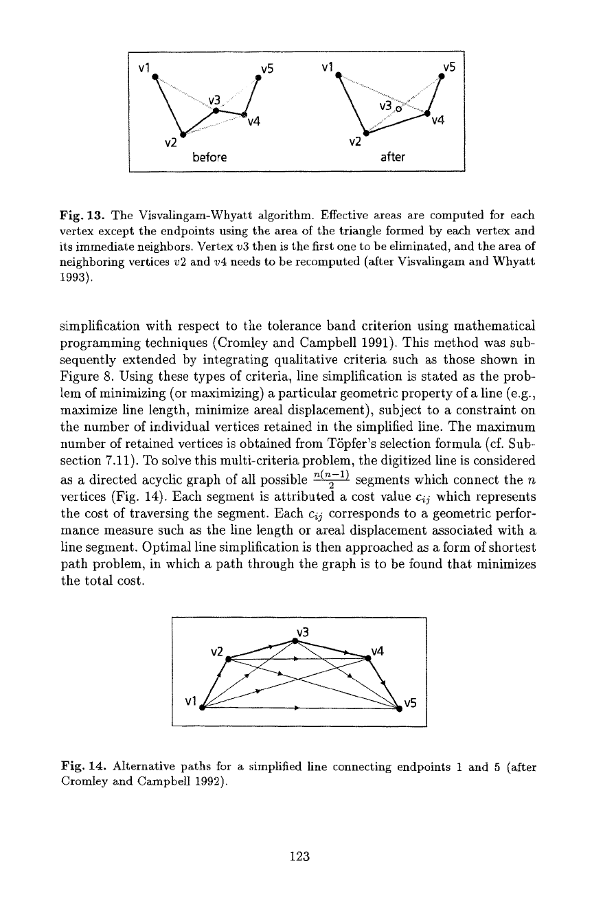
vl v5 vl
v5
before after
Fig. 13. The Visvalingam-Whyatt algorithm. Effective areas are computed for each
vertex except the endpoints using the area of the triangle formed by each vertex and
its immediate neighbors. Vertex v3 then is the first one to be eliminated, and the area of
neighboring vertices v2 and v4 needs to be recomputed (after Visvalingam and Whyatt
1993).
simplification with respect to the tolerance band criterion using mathematical
programming techniques (Cromley and Campbell 1991). This method was sub-
sequently extended by integrating qualitative criteria such as those shown in
Figure 8. Using these types of criteria, line simplification is stated as the prob-
lem of minimizing (or maximizing) a particular geometric property of a line (e.g.,
maximize line length, minimize areal displacement), subject to a constraint on
the number of individual vertices retained in the simphfied line. The maximum
number of retained vertices is obtained from TSpfer's selection formula (cf. Sub-
section 7.11). To solve this multi-criteria problem, the digitized line is considered
as a directed acyclic graph of all possible ~ segments which connect the n
vertices (Fig. 14). Each segment is attributed a cost value c~j which represents
the cost of traversing the segment. Each
cij
corresponds to a geometric perfor-
mance measure such as the line length or areal displacement associated with a
line segment. Optimal line simplification is then approached as a form of shortest
path problem, in which a path through the graph is to be found that minimizes
the total cost.
v3
v2 ~v4
vl ~v5
Fig. 14. Alternative paths for a simphfied line connecting endpoints t and 5 (after
Cromley and Campbell 1992).
123
7.3 Line Smoothing
Line smoothing in many ways forms a complement to line simplification. Ac-
cording to the definition commonly used, line smoothing techniques "shift the
position of points in order to improve the appearance [of a line]. Smoothing al-
gorithms relocate points in an attempt to plane away small perturbations and
capture only the most significant trends of the line. Thus smoothing is used pri-
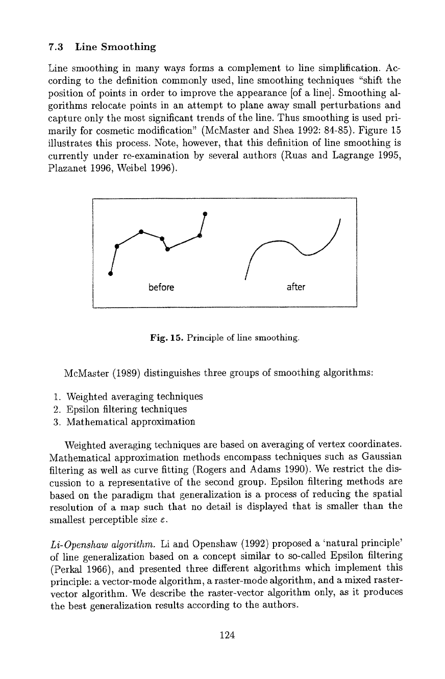
marily ibr cosmetic modification" (McMaster and Shea 1992: 84-85). Figure 15
illustrates this process. Note, however, that this definition of line smoothing is
currently under re-examination by several authors (Ruas and Lagrange 1995,
Plazanet 1996, Weibel 1996).
p/
before
after
Fig. 15. Principle of line smoothing.
McMaster (1989) distinguishes three groups of smoothing algorithms:
1. Weighted averaging techniques
2. Epsilon filtering techniques
3. Mathematical approximation
Weighted averaging techniques are based on averaging of vertex coordinates.
Mathematical approximation methods encompass techniques such as Gaussian
filtering as well as curve fitting (Rogers and Adams 1990). We restrict the dis-
cussion to a representative of the second group. Epsilon filtering methods are
based on the paradigm that generalization is a process of reducing the spatial
resolution of a map such that no detail is displayed that is smaller than the
smallest perceptible size ¢.
Li-Openshaw algorithm.
Li and Openshaw (1992) proposed a 'natural principle'
of line generalization based on a concept similar to so-called Epsilon filtering
(Perkal 1966), and presented three different algorithms which implement this
principle: a vector-mode algorithm, a raster-mode algorithm, and a mixed raster-
vector algorithm. We describe the raster-vector algorithm only, as it produces
the best generalization results according to the authors.
124
In a first step, the size Fc of the 'smallest visible object' (SVO) at the target
scale is estimated according to the formula
Fc=StD 1-~t (2)
where St is the scale factor of the target map; D is the diameter of the SVO
at the target map scale (in map units), within which all information can be
neglected; and S~ is the scale factor of the source map.
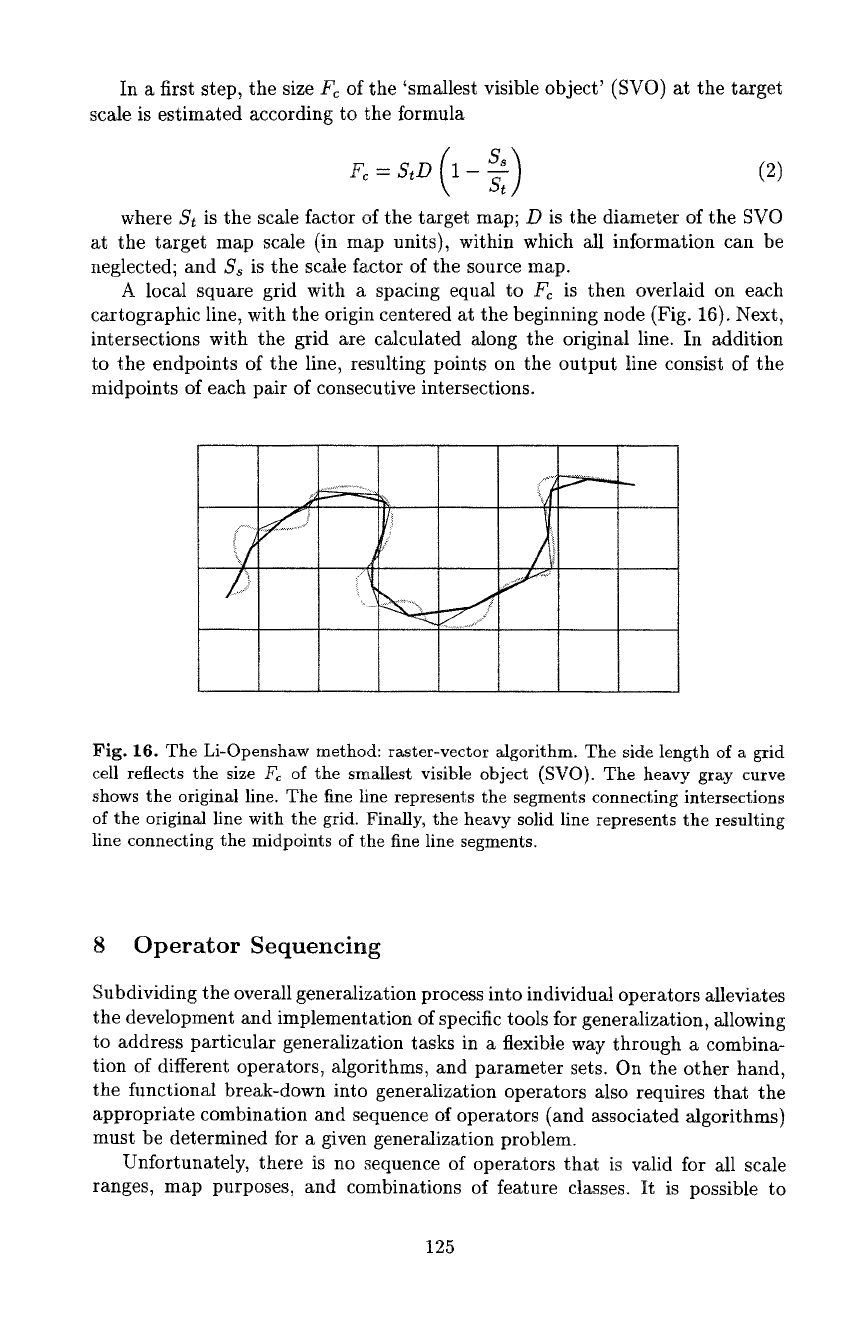
A local square grid with a spacing equal to Fc is then overlaid on each
cartographic line, with the origin centered at the beginning node (Fig. 16). Next,
intersections with the grid are calculated along the original line. In addition
to the endpoints of the line, resulting points on the output line consist of the
midpoints of each pair of consecutive intersections.
?
S
t
Fig. 16. The Li-Openshaw method: raster-vector algorithm. The side length of a grid
cell reflects the size Fc of the smallest visible object (SVO). The heavy gray curve
shows the original line. The fine line represents the segments connecting intersections
of the original line with the grid. Finally, the heavy solid line represents the resulting
line connecting the midpoints of the fine line segments.
8 Operator Sequencing
Subdividing the overall generalization process into individual operators alleviates
the development and implementation of specific tools for generalization, allowing
to address particular generalization tasks in a flexible way through a combina-
tion of different operators, algorithms, and parameter sets. On the other hand,
the functional break-down into generalization operators also requires that the
appropriate combination and sequence of operators (and associated algorithms)
must be determined for a given generalization problem.
Unfortunately, there is no sequence of operators that is valid for all scale
ranges, map purposes, and combinations of feature classes. It is possible to
125
some extent to develop generic sequences for a particular
class
of generalization
problems and product specifications (e.g., for generalization of landuse maps
at medium to small scales). For each specific generalization problem, however,
the operator/algorithm combination and sequence has to be fine-tuned and cal-
ibrated specifically. It is also a common fact that if two algorithms - with the
same parameter values - are applied in reverse order, the result will not be the
same (Monmonier and McMaster 1991, Plazanet 1996).
Research in operator and algorithm sequencing is still relatively sparse to
date. Examples include Lichtner (1979) who proposed a generic sequence for
large scale topographic map generalization, McMaster (1989) and Monmonier
and McMaster (1991) with studies on sequential effects of line simplification and
smoothing algorithms, and Lecordix et al. (1997) with empirical comparisons of
line caricature algorithms. McMaster (1989) proposes a detailed procedure for
generalizing linear data in which both smoothing and simplification are applied
in two phases. In the first phase, smoothing precedes simplification (both using
conservative parameter values) in order to remove spurious effects of digitizing.
During the second phase, simplification is used for an initial generalization to
target scale, with subsequent smoothing to improve the aesthetic quality of line
drawing.
In today's interactive generalization systems the issue of operator and algo-
rithm sequencing is even more important due to the large number of Mgorithms
offered in systems of the type described by Lee (1995). Interactive systems, how-
ever, also allow to establish algorithm sequences under interactive control, with
the option to fine-tune and 'train' parameter sets on representative sample data
in order to subsequently apply them globally to the entire data set. Finally,
some pragmatic general guidelines for operator sequences can be derived from
cartographic practice:
-
Selection/elimination:
Is applied first as it eliminates insignificant details
and features and increases available space.
- Aggregation/amalgamation/merging:
These operators combine selected fea-
tures and thus save space. AdditionMly, they induce a transition of topologi-
cM type (e.g., point to area~ double lines to single line, area to line) and thus
must precede line processing operators (simplification, smoothing, etc.).
-
Simplification:
Reduces detail and contributes to line caricature. Should
therefore be applied at an early stage.
- Smoothing:
Contributes to aesthetical refinement. Follows simplification.
- Displacement:
Used to resolve spatial conflicts created by previous operators.
9 Model Generalization - The Example of TIN Filtering
As was explained above model generalization functions are crucial to the devel-
opment and derivation of
databases
at multiple levels of resolution. Frequently,
model generalization relies on the exploitation of hierarchies which are inherent
to spatial data. For instance, in the attribute (i.e., thematic) domain, the classi-
cal example of inherent hierarchies are categorical data such as land use or soil
126
classifications. Such intrinsic relations can be formalized for storage and retrieval
(Molenaar 1996b, Richardson 1994). In this section, however, we concentrate on
a single example of a
geometric
model generalization process. Further examples
of model generalization methods - involving aspects of thematic and temporal
model generalization - can be found in the reader edited by Molenaar (1996@
Filtering operations for data reduction are an essential component of terrain
modeling systems. As more and larger datasets are being processed and new
methods for high-density data collection are being put to use, the necessity for
an adaptation of secondary models to the desired resolution and accuracy is
becoming more urgent. For instance, it is not necessary to carry all the minute
details contained in a particular model through the generation of an animated
sequence if the result does not show them. TIN filtering can be desirable to elim-
inate redundant data points within the sampling tolerance, to detect blunders,
to save storage space and processing time, to homogenize a TIN, or to convert a
gridded terrain model into a TIN. It may also be used as a component of terrain
generalization (Weibel 1992; cf. Subsection 12.3).
The
objective of TIN filtering
is to find an approximate representation
of a field of elevations, that is, a bivariate function which nowhere deviates
from the original surface by more than a specified tolerance
Az.
TIN filtering
thus essentially forms the 3-D equivalent of the simplification of plane curves
(Subsection 7.2).
Van Kreveld (1997) gives further references to algorithms for TIN filtering.
Our discussion focuses on the role of TIN filtering in model generalization and
briefly presents a particular incremental algorithm developed by Heller (1990),
termed 'adaptive triangular mesh (ATM) filtering'. It is based on a coherent
approach of successive construction of Delaunay triangulations. However, the
method can be used to reduce the data volume of both grids and TINs. A grid is
just considered as a special case of a TIN, with nodes arranged in a rectangular
grid. The general flow of the algorithm is as follows:
1. Start with an initial set of points: selected points on the convex hull and the
significant extremes.
2. Triangulate these points to build an initial triangulation.
3. Determine the priority of the remaining points forming the initial priority
queue. The priority of a point is calculated as the vertical distance to the
current triangular mesh weighted by the inverse of the tolerance
Az.
4. Select the point with the largest priority and insert it into the triangulation,
swapping edges of affected triangles to maintain the Delaunay criterion.
5. Readjust the priorities of the affected points.
6. Repeat steps 4 and 5 until no point remains whose vertical distance exceeds
the user-specified tolerance Az.
A few auxiliary data structures are used to achieve an efficient algorithm.
The priority queue of points waiting to be inserted into the triangulation is
organized in a heap. The points pertaining to each triangle are linked into a
list. The insertion of a point requires a local retriangulation which consists of
127
swapping all necessary triangles to maintain the Delaunay criterion, and read-
justing the priorities of all affected points. It is obvious that the time required
for retriangulation is proportional to the number of readjusted points and the
logarithm of the number of queued points. Therefore, a heuristic is used to start
the process with as many significant points as possible.
The set of initial points is formed by selected points on the convex hull and
the
significant extremes.
The points which are selected on the hull include all
consecutive hull points which are not collinear (i.e., not in line with respect
to their planimetric location). Collinear points are handled specially, which is
particularly important when the input points originate from a regular grid, since
all points on the edge of the grid are collinear. A variant of the Douglas-Peucker
algorithm is applied to the profile of collinear points using
Az
as a distance
tolerance. Local extremes form further candidates for the initial point set. The
following definitions are used to select the
significant extremes:
- A local minimum is considered as significant if it is the global minimum in
a basin of depth greater or equal
Az.
-
A local maximum is considered as significant if it is the global maximum on
a hill of height greater or equal
Az.
These definitions lead to a straightforward approach for the determination
of local minima and maxima. The local, minima are sorted by their altitude
by inserting them into a priority queue. Then, the following step is repeated
until all minima in the queue are tested. The lowest remaining minimum z~ is
selected, and the points in its neighborhood traversed radially until the lowest
point along the 'wavefront' of this traversal is higher than z~ + Az. If a local
minimum is found in this process, it can be removed from the priority queue.
As soon as a point is found which is lower than z~, the traversal is aborted and
the current minimum discarded. The same method is also used in an analogous
way to determine significant maxima.
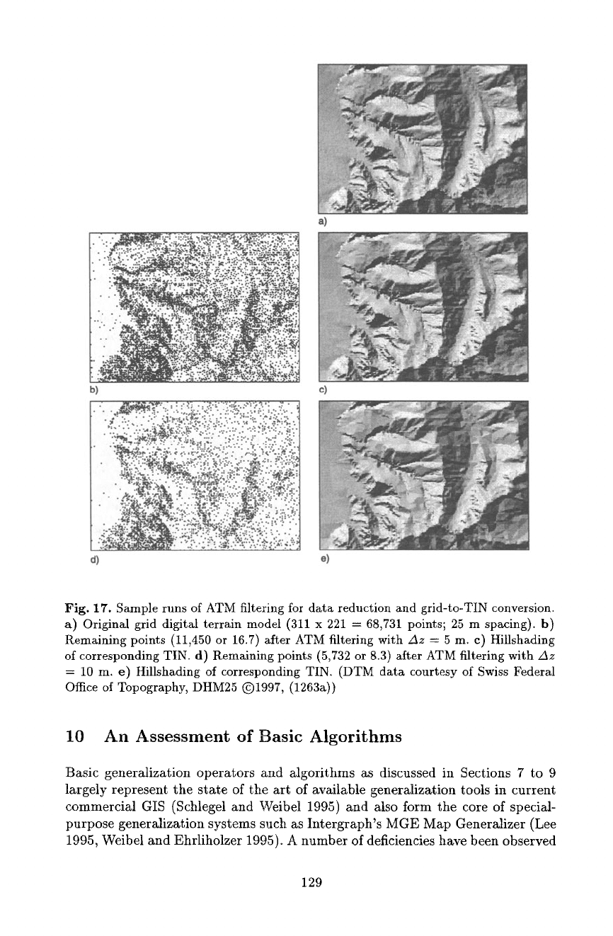
An example of ATM filtering is shown in Figure 17: starting from a gridded
digital terrain model (68,731 points), a TIN with a tolerance of 5 m (with 11,450
points or 16.Tremaining), and a TIN with a tolerance of 10 m (5,732 points or
8.3) were obtained.
The fact that for the determination of the significance of a point the vertical
distance is weighted offers the potential for useful extensions. In the normal
case, the weight is set to the inverse of
Az,
and therefore constant. However, the
weight can also be modified individually according to the specific properties of
each point. For instance, points on structure lines can be assigned higher weights
than others, thus enabling the preservation of linear structural features. In a
similar way, the level of detail of perspective views can be adjusted according
to viewing depth. Height values of points can be weighted according to some
function that is proportional to the inverse of the distance of a point to the
viewpoint (Hess 1995, Misund 1996)~ Points near the viewer are thus assigned
higher weights than distant ones, causing more points to be removed from the
TIN in distant regions which are less likely to be discernible.
128
". ~,~:.~:.':~':~.=:'-:.'~:,t
.... • . ~? .~.-.-:.: :::...
b)
.:,~... ,,~,~..,, ........ . ....
~:4~': ~';';; '.~'I. • " : " :~,".'.."<" ": : : :
a!,':':.~:~::]'.:"
!i?"" ':'::" :':" :~
4_- ~'i'~. v:-/,¢~:.~f~:::.' ,~:~.,:.. ',v.-:': ":" ". I
d)
a)
Fig. 17. Sample runs of ATM filtering for data reduction and grid-to-TIN conversion.
a) Original grid digital terrain model (311 x 221 = 68,731 points; 25 m spacing), b)
Remaining points (11,450 or 16.7) after ATM filtering with Az = 5 m. c) Hillshading
of corresponding TIN. d) Remaining points (5,732 or 8.3) after ATM filtering with z3z
= 10 m. e) Hillshading of corresponding TIN. (DTM data courtesy of Swiss Federal
Office of Topography, DHM25 ©1997, (1263a))
10 An Assessment of Basic Algorithms
Basic generalization operators and algorithms as discussed in Sections 7 to 9
largely represent the state of the art of available generalization tools in current
commercial GIS (Schlegel and Weibel 1995) and also form the core of special-
purpose generalization systems such as Intergraph's MGE Map Generalizer (Lee
1995, Weibel and Ehrliholzer 1995). A number of deficiencies have been observed
129
and documented in the literature (Muller 1990, Beard 1991, Plazanet et al. 1995,
de Berg et al. 1995, Weibel and Ehrliholzer 1995, Lecordix et al. 1997). This
section presents a brief assessment of basic generalization methods, attempting
to identify weaknesses as well as key areas for future research. Note that the
discussion primarily focuses on
functional
deficiencies and improvements, rather
than on aspects of computational efficiency. In an evaluation of the quality of
today's generalization methods computational efficiency is only secondary to a
functional assessment. Many methods just don't do what they are expected to
do, so producing garbage fast is not really an objective. However, we certainly
appreciate the importance of computationally efficient methods in the context
of interactive generalization and databases of increasing size.
10.1 "What's Wrong with Basic Algorithms?
Based on the study of the above literature as well as empirical investigations
(Schlegel and Weibel 1995, Weibel and Ehrliholzer 1995) we have identified a
number of weaknesses of basic generalization methods with respect to algorithms
and data structures, which can be summarized as follows:
- Independent processing of individual features neglects spatial context.
- Structure and shape recognition for the characterization of map objects is
restricted to simple heuristics (such as the tolerance band). It is not explicitly
represented in terms of shape measures and spatial relations.
- Algorithms are unspecific; they are not tailored to the properties of specific
feature classes (e.g., simplification of building outlines).
-
Algorithms to implement context-dependent operators (displacement, amal-
gamation, aggregations caricature, etc.) are largely missing.
- Feature representations and data structures commonly used offer little sup-
port for structure recognition and context-dependent operators.
10.2 What Should Be Improved?
The necessary improvements of basic algorithmic methods and the development
of more advanced algorithms basically fall into three (strongly interrelated) ar-
eas:
- Constraint-based methods:
Algorithms must observe the spatial and semantic
constraints imposed by map context.
- Methods for structure and shape recognition:
Structure recognition must be
made explicit. Analysis of shape and structure of map features must pre-
cede the execution of generalization algorithms. It is necessary to select an
appropriate set of operators, algorithms and parameter values.
- Alternative data representations and data models:
Generalization requires a
rich data model encompassing a combination of different data representations
and auxiliary data. structures.
130
