Van Kreveld M., Nievergelt J., Roos T., Widmayer P. (eds.) Algorithmic Foundations of Geographic Information Systems
Подождите немного. Документ загружается.

Schylberg, L. (1993): Computational Methods for Generalization of Car-
tographic Data in a Raster Environment. PhD Thesis, Department
of Photogrammetry, Royal Institute of Technology, Stockholm.
Shreve, R.L. (1966): Statistical Law of Stream Number. Journal of Ge-
ology, 74: 17-37.
Spiess, E. (1995): The Need for Generalization in a GIS Environment.
In: Mfiller, J-C., Lagrange, J.-P., and Weibel, R. (eds.): GIS and
Generalization: Methodological and Practical Issues, London: Taylor
& Francis, 31-46.
Strahler, A.N. (1957): Quantitative Analysis of Watershed Geomorphol-
ogy. Transactions of the American Geophysical Union, 8(6): 913-920.
Swiss Society of Cartography (1977): Cartographic Generalization - To-
pographic Maps. Cartographic Publication Series, vol. 2. Zurich: Swiss
Society of Cartography.
T6pfer, F. (1974): Kartographische Generalisierang. Gotha, Leipzig: VEB
Hermann Haack.
van Kreveld, M. (1997): Digital Elevation Models: Overview and Selected
TIN Algorithms. This volume.
van Oosterom, P. and van den Bos, J. (1989): An Object-Oriented Ap-
proach to the Design of Geographic Information Systems. Computers
Graphics, 13: 409-418.
van Oosterom, P. and Schenkelaars, V. (1995): The Development of an
Interactive Multiscale GIS. International Journal of Geographical In-
formation Systems, 9(5): 489-507.
Visvalingam, M., and Whyatt, J.D. (1993): Line Generalisation by Re-
peated Elimination of Points. Cartographic Journal, 30(1): 46-51.
Visvalingam, M. and Williamson, P.J. (1995): Simplification and Gen-
eralization of Large Scale Data for Roads: A Comparison of Two
Filtering Algorithms. Cartography and Geographic Information Sys-
tems, 22(4): 264-275.
Ware, J.M., Jones, C.B. and Bundy, G.LI. (1995): A Triangulated Spatial
Model for Cartographic Generalisation of Areal Objects. In: Frank,
A.U. and Kuhn, W. (eds.): Spatial Information Theory - A The-
oretical Basis for GIS (Proceedings COSIT '95). Lecture Notes in
Computer Science 988, Berlin, Springer-Verlag: 173-192.
Ware, J.M. and Jones, C.B. (1996): A Spatial Model for Detecting (and
Resolving) Conflict Caused by Scale Reduction. In: Kraak, M.J. and
Molenaar, M. (eds.): Advances in GIS research II (Proceedings 7th
International Symposium on Spatial Data Handling), London: Taylor
& Francis: 9A.15-9A.26.
Weibel, R. (1991): Amplified Intelligence and Rule-Based Systems. In:
Buttenfield, B.P., and McMaster, R.B. (eds.): Map Generalization
- Making Rules for Knowledge Representation. London: Longman,
172-186.
Weibel, R. (1992): Models and Experiments for Adaptive Computer-
Assisted Terrain Generalization. Cartography and Geographic Infor-
mation Systems, 19(3): 133-153.
151
Weibel, R. (1995a): Map Generalization. Special Issue of Cartography
and Geographic Information Systems, 22(4).
Weibel, R. (1995b): Three Essential Building Blocks for Automated Gen-
eralisation. In: Miiller, J-C., Lagrange, J.-P., and Weibel, R. (eds.):
GIS and Generalization: Methodological and Practical Issues, Lon-
don: Taylor & Francis, 56-69.
Weibel, R. and Ehrliholzer, R. (1995): An Evaluation of MGE Map Gen-
eralizer. Internal Report, Department of Geography, University of
Zurich, 36 + 18 pgs.
Weibel, R., Keller, St., and Reichenbacher, T. (1995): Overcoming the
Knowledge Acquisition Bottleneck in Map Generalization: The Role
of Interactive Systems and Computational Intelligence. In: Frank,
A.U. and Kuhn, W. (eds.): Spatial Information Theory - A The-
oretical Basis for GIS (Proceedings COSIT '95). Lecture Notes in
Computer Science 988, Berlin, Springer-Verlag: 139-156.
Weibel, R. (1996): A Typology of Constraints to Line Simplification.
In: Kra~k, M.J. and Molenaar, M. (eds.): Advances in GIS research
H (Proceedings 7th International Symposium on Spatial Data Han-
dling), London: Taylor & Francis: 9A.1-9A.14.
Werschlein, T. (1996): Frequenzbasierte Linienrepriisentationen fiir die
kartographische Generatisierung. MSc Thesis, Department of Geog-
raphy, University of Zurich.
White, E.R. (1985): Assessment of Line Generalization Algorithms Using
Characteristic Points. The American Cartographer, 12(1): 17-28.
152
Chapter 6. Spatial Data Structures:
Concepts and Design Choices
Jfirg Nievergelt
Dept. of Computer Science
ETH Ziirich
Switzerland
jn@inf, ethz. ch
Peter Widmayer
Dept. of Computer Science
ETH Zfirich
Switzerland
widmayerOinf, ethz.
ch
1 Goals and Structure of this Survey
The growing importance of graphic user interfaces and of applications such as
computer-aided design and geo-information systems has confronted many appli-
cations programmers with a challenging new task: Processing large amounts of
spatial data, off disk, correctly and efficiently. The task is daunting, as spatial
data poses distinctly novel problems as compared to traditional "business data",
in particular the following two:
1. Access is primarily via proximity relations to other objects that populate Eu-
clidean space, rather than via inherent properties of objects, such as attribute
values. A typical query is of the form "retrieve all objects that intersect a
given region of space".
2. Guaranteed correctness in processing spatial objects has proven to be a
thorny problem requiring a systematic analysis of degenerate configurations.
Moreover, efficiency depends on the interplay between two techniques: one
for representing an object (independently of its location in space), the other
for storing the entire collection of objects in relation to their position in
space.
We aim to provide a guide through the bewildering multitude of concepts, tech-
niques and choices a programmer faces when designing a data structure for
managing spatial data. We simplify this task by separating the question of how
an object is represented for internal processing (an issue in computational ge-
ometry that we shall not address), from the question of how a large collection
of simple objects embedded in space are managed on disk (the crucial issue of
153
spatial data management systems). Although object representation and external
data structures may be intertwined, for example in image processing, they are
treated separately in many important applications. In geoinformation systems,
for example, objects of complex shape are routinely approximated or bounded
by simple containers for retrieval purposes.
The tutorial approach we have chosen for this survey begins with the histor-
ical development of data structures in general, a trend from which spatial data
in particular emerged as a separate discipline relatively late. In spite of the pro-
found differences between spatial data on the one hand, and conventionM data
typical of the business applications that shaped the development of database
technology on the other hand, the community of database researchers persisted
in forcing "non-standard (including spatial) data" into a mold that had proven
effective for other applications. It took a long time to realize that data structures
inherited or adapted from single-key access had to be reconsidered, and often
abandoned. Thus a brief sketch of the development of data structures in Section
2 serves the double purpose of reviewing the basic notions of data structures,
and of identifying key differences between spatial and other data.
A second characteristic of our tutorial approach is to start from about a dozen
concepts or features that appear to cover most of the many spatial data struc-
tures described in the literature. This approach assigns to every data structure a
"profile" that facilitates assessment of its strong and weak points, and compar-
ison with others. Thus we avoid enumerating the many spatial data structures
described in the literature, which often differ only in details, and instead focus
on the building blocks from which a programmer can assemble his own data
structure tailored to the specific requirements of a given task.
Thus, Section 3 presents important concepts needed to discuss spatial data
structures at an intuitive level. This includes a list of basic questions to be
raised and considerations to be aware of before a programmer decides on data
representation and storage technique. The latter have a pervasive influence on
the complexity and efficiency of any application that processes spatial data.
Having assembled an arsenal of concepts and terminology, Section 4 presents
a concise model that captures the essence of the majority of spatial data struc-
tures and the way they process queries. By separating three key aspects: the
organization of the embedding space into a collection of cells, the organization
of objects into cell populations, and the internal representation of an object,
we arrive at a three-step query processing model that serves as a skeleton for
understanding, assessing and comparing most spatial data structures.
So far we have merely mentioned a few examples of specific data structures,
out of several dozen known today. Sections 5 and 6 continue by systematically
listing the major building blocks that go into the design of a spatial data struc-
ture, and providing examples of structures for possible design choices. Section
5 treats points, the simplest kind of spatial object, whereas Section 6 discusses
extended objects. By following an approach "from general concepts to specific
examples", we hope to help a reader to program an appropriate data structure
154
based on half a dozen design choices, rather than by scanning a vast literature
that includes hundreds of research papers.
The concluding Section 7 attempts to summarize the survey with a simple
point of view: Design and choice of spatial data structures, today, is a matter of
common sense more than of technical wizardry. Don't let hundreds of research
papers prevent you from seeing the forest because of all the trees. With a clear
understanding of a dozen fundamental concepts characteristic of spatial data,
you can choose a data structure suited to your application.
2 Data Structures Old and New, and the Forces that
Shaped Them
2.1 Prehistory, Logical vs. Physical Structure
The discipline of data structures, as a systematic body of knowledge, is truly a
creation of computer science. The question of how to organize data was a tot
simpler to answer in the days before the existence of computers: The organization
had to be simple, because there was no automatic device capable of processing
intricately structured data, and there is no human being with enough patience
to do it. Consider two examples.
1. Manual files and catalogs, as used in business offices and libraries, exhibit
several distinct organizing principles, such as sequential and hierarchical or-
der and cross-references. From today's point of view, however, manual files
are not well-defined data structures. For good reasons, people did not rig-
orously define those aspects that we consider essential when characterizing
a data structure: what constraints are imposed on the data, both on the
structure and its content; what operations the data structure must support;
what constraints these operations must satisfy. As a consequence, searching
and updating a manual file is not typically a process that can be automated:
It requires common sense, and perhaps even expert training, as is the case
for a library catalog.
2. In manual computing (with pencil and paper or a nonprogrammable calcu-
lator) the algorithm is the focus of attention, not the data structure. Most
frequently, the person computing writes data (input, intermediate results,
output) in any convenient place within his field of vision, hoping to find
them again when he needs them. Occasionally, to facilitate highly repetitive
computations (such as income tax declarations), someone designs a form to
prompt the user, one operation at a time, to write each data item into a
specific field. Such a form specifies both an algorithm and a data structure
with considerable formality, but is necessarily special purpose.
Edge-notched cards are perhaps the most sophisticated data structures ever
designed for manual use. Let us illustrate them with the example of a database
of English words organized so as to help in solving crossword puzzles. We write
one word per card and index it according to which vowels it contains and which
155
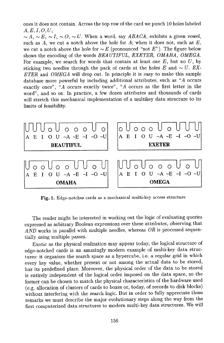
ones it does not contain. Across the top row of the card we punch i0 holes labeled
A,E,I,O,U,
A, ~ E, ~ I, ~ O, --. U. When a word, say
ABAUA,
exhibits a given vowel,
such as A, we cut a notch above the hole for A; when it does not, such as E,
we cut a notch above the hole for ~ E (pronounced "not E"). The figure below
shows the encoding of the words
BEAUTIFUL, EXETER, OMAHA, OMEGA.
For example, we search for words that contain at least one E, but no U, by
sticking two needles through the pack of" cards at the holes E and
,.- U. EX-
ETER
and
OMEGA
wilt drop out. In principle it is easy to make this sample
database more powerful by including additional attributes, such as "A occurs
exactly once",
"A
occurs exactly twice",
"A
occurs as the first letter in the
word", and so on. In practice, a few dozen attributes and thousands of cards
will stretch this mechanical implementation of a multikey data structure to its
limits of feasibility.
BEAUTIFUL
O0
I 0
U ~A -E -I ~O -U[
EXETER ]
o
U -A -E -I -O -U t U -A -E
OMAHA ] OMEGA
Fig. 1. Edge-notches cards as a mechanical multi-key access structure
The reader might be interested in working out the logic of evaluating queries
expressed as arbitrary Boolean expressions over these attributes, observing that
AND
works in parallel with multiple needles, whereas OR is processed sequen-
tially using multiple passes.
Exotic as the physical realization may appear today, the logical structure of
edge-notched cards is an amazingly modern example of multi-key data struc-
tures: it organizes the search space as a hypercube, i.e. a regular grid in which
every key value, whether present or not among the actual data to be stored,
has its predefined place. Moreover, the physical order of the data to be stored
is entirely independent of the logical order imposed on the data space, so the
former can be chosen to match the physical characteristics of the hardware used
(e.g. allocation of clusters of cards to boxes or, today, of records to disk blocks)
without interfering with the search logic. But in order to fully appreciate these
remarks we must describe the major evolutionary steps along the way from the
first computerized data structures to modern multi-key data structures. We will
156
observe that each era that focused on new application domains created new
techniques to address concerns not adequately met by prior developments.
2.2 Early Scientific Computation: Static Data Sets
Numerical computation in science and engineering mostly leads to linear algebra
and hence matrix computations. Matrices are static data sets: The values change,
but the shape and size of a matrix rarely does - this is true even for most sparse
matrices, such as band matrices, where the propagation of nonzero elements
is bounded. Arrays were Goldstine and yon Neumann's answer to the require-
ment of random access, as described in their venerable 1947 report "Planning
and coding of problems for an electronic computing instrument". FORTRAN
'54 supported arrays and sequential files, but no other data structures, with
statements such as DIMENSION, READ TAPE, REWIND, and BACKSPACE.
Table look-up was also solved early through hashing. The software pioneers
of the first decade did not look beyond address computation techniques (array
indexing and hashing) because memories were so small that any structure that
"wastes" space on pointers was considered a luxury. Memories containing a few K
words restricted programmers to using only the very simplest of data structures,
and the limited class of problems addressed let them get away with it. The
discipline of data structures had yet to be created.
2.3 Commercial Data: Batch Processing of Dynamic Sets, Single
Key Access
Commercial data processing led to the most prolific phase in the development of
data structures. The achievements of the early days were comprehensively pre-
sented in Knuth's pioneering books on "The Art of Computer Programming"
(Knuth 1968, 1973). These applications brought an entirely different set of re-
quirements for managing data typically organized according to a single 'primary
key'. When updating an ordered master file with unordered transaction files,
sorting and merging algorithms determine data access patterns. The emergence
of disk drives extended the challenge of data structure design to secondary stor-
age devices. Bridging the 'memory-speed gap' became the dominant practical
problem. Central memory and disk both look like random access devices, but
they differ in the order of magnitude of two key parameters:
Memory Disk Ratio:
Disk/Memory
Access time (seconds): 10-7... 10 .6 10-2... 10 -~ 104... 105
Size of transfer unit (bits): 10... 102 104 ... 105 10~... 103
In recent decades technology has reduced both time parameters individually,
but their ratio has remained a 'speed gap' of about 4 orders of magnitude. This
fact makes the number of disk accesses the most relevant performance pa-
rameter of external data structures. Many data structures perform well in central
157
memory, but disk forces us to be more selective; disks call for data structures
that avoid pointer chains that indiscriminately cross disk block boundaries. The
game of designing data structures suitable for disk has two main rules: the easy
one is to use a small amount of central memory effectively to describe the current
allocation of data on disk in a way that facilitates rapid retrieval; the hard one
is to ensure that the structure adapts gracefully to the ever-changing content of
the file.
Index-sequential access methods (ISAM) order records according to a single
key so that a small directory, preferably kept in central memory, ideally directs
any point query to the correct data bucket where the corresponding record is
stored, if it is present at all. But the task of maintaining this single-disk-access
performance in a dynamic file, in the presence of insertions and deletions, is far
from trivial. The first widely used idea, of splitting storage into a primary area
and an overflow area, suffers from now well-known defects.
Balanced trees, one of the major achievements of data structure design,
provide a brilliant solution to the problem_ of 'maintaining large ordered in-
dexes' without degradation. They come in many variations (e.g. Adetson-Velski
et al. 1962, Bayer et al. 1972) all based on the same idea: Frequent small rebal-
ancing operations that work in logarithmic time eliminate the need for periodic
reorganization of the entire file. Trees based on comparative search derive their
strength from the ease of modifying list structures in central memory. They have
been so successful that we tend to apply and generalize them beyond their nat-
ural limitations. In addition to concerns about the suitability of comparative
search trees for multikey access, discussed in the next section, these limitations
include (Nievergelt et al. 1981):
1. The number of disk accesses grows with the height of the tree. Depending
on the size of the file and the fan-out from a node, or from a page contain-
ing many nodes, the tree may well have too many levels fbr instantaneous
retrieval.
2. Concurrency. Every node in a tree is the sole entry point to the entire subtree
rooted at that node, and thus a bottleneck for concurrent processes that pass
through it, even if they access different physical storage units. Early papers
(e.g. Bayer et al. 1977, Kung et al. 1980) showed that concurrent access to
trees implemented as lists requires elaborate protocols to insure integrity of
the data.
2.4 Transaction Processing: Interactive Multikey Access to
Dynamic Sets
Whereas single-key access may suffice for batch processing, transaction process-
ing, as used in reservations or banking systems, calls for multikey access (by
name, date, location, etc.). The simplest ideas were tried first. Inverted files try
to salvage single-key structures by ordering data according to a 'primary key',
and 'inverting' the resulting file with respect to all other keys, called 'secondary'.
158
Whereas the primary directory is compact as in ISAM, the secondary directo-
ries are voluminous: Typically, each directory has an entry for every record. Just
updating the directories makes insertion and deletion time-consuming.
Comparative search trees enhanced ISAM by eliminating the need for over-
flow chains, so it was natural to generalize them to multikey access and improve
on inverted files. This is easy enough, as first shown by
k-d
trees (Bentley 1975).
But the resulting multi-key structures are neither as elegant nor as efficient as
in the single-key case. The main hindrance is that no total order can be imposed
on multidimensional space without destroying proximity relationships. As a con-
sequence, the simple rebalancing operations that work for single-key trees fail,
and rebalancing algorithms must resort to more complicated and less efficient
techniques, such as general dynamization (Willard 1978, Overmars 1981).
Variations and improvements on multidimensional comparative
search trees continue to appear (e.g. Lomet et al. 1989, 1990). Their main virtue,
acceptable worst case bounds, comes from the fact that they partition the actual
data to be stored into (nearly) equal parts. The other side of this coin is that
data is partitioned
regardless of where in space it is located.
Thus the resulting
space partitions exhibit no regularity, in marked contrast to radix partitions that
organize space into cells of predetermined size and location.
2.5 Knowledge Representation: Associative Recall in Random Nets
There is a class of applications where data is most naturally thought of as a
graph, or network, with nodes corresponding to entities and arcs to relation-
ships among these. Library catalogs in information retrieval, hypertexts with
their many links, semantic nets in artificial intelligence are examples. The char-
acteristic access pattern is 'browsing': A probe into the net followed by a walk to
adjacent nodes. Typically, a node is not accessed because of any inherent char-
acteristic, but because it is associated with (linked to) a node currently being
visited. The requirements posed by this type of problem triggered the develop-
ment of list processing techniques and list processing languages.
These graphs look arbitrary, and the access patterns look like random walks
- neither data nor access patterns exhibit any regular structure to be exploited.
The general list structures designed for these applications have not evolved much
since list processing was created, at least not when compared to the other data
structures discussed. The resulting lack of sophisticated data structures for pro-
cessing data collections linked as arbitrary graphs reminds us that efficient algo-
rithms and data structures are always tailored to the presence of specific prop-
erties to be exploited, in particular to a regular structure of the data space. If
the latter has no regular structure to be exploited, access degrades to exhaustive
search.
Information retrieval is an example of an application where "random" struc-
ture cannot be avoided. Although a catalog entry in a library is a record with a
regularly structured part, e.g. document = (author, title, publisher, year), search
by content relies on index terms chosen from a large thesaurus of thousands of
concepts, ranging from "Alchemy" to "Zen'. It does not help to consider 1000
159
index terms, each with a range of perhaps only two values "relevant" and "irrel-
evant", as attributes of a multi-key data structures, which typically are designed
to handle at most tens of access keys.
2.6 Spatial Data Management: Proximity Access to Objects
Embedded in
Space
In typical applications that rely on spatial data, such as computer-aided design
or geoinformation systems, many or all of the requirements listed so far are
likely to appear: interactive transaction processing, random-looking networks of
references among functionally related components, etc. In addition to such non-
spatial requirements, spatial data imposes three key characteristics that sets
spatial data management apart from the cases described above:
I. Data represents objects embedded in some d-dimensional Euclidean space
~d
2. These objects are mostly accessed through their location in space, in re-
sponse to a proximity query such as intersection with some query region, or
containment therein.
3. A typical spatial object has a significantly more complex structure than a
'record' in the other applications mentioned.
Although other applications share some of these characteristics to a small extent,
in no other do they play a comparably important role. Let us highlight the
contrast with the example of a collection of records, each with two attributes,
'social security number' (SSN) and 'year of birth'.
i. Although it may be convenient to consider such a record to be a point in a
2-d attribute space, this is not a Euclidean space~ the distance between two
such points, for example, or even the distance between two SSNs, is unlikely
to be meaningful.
2. Partial match and orthogonal range queries are common in data processing
applications, but more complex query regions are rare. In contrast, arbitrar-
ily complex query regions are common in geometric computation (e.g, inter-
section of objects, or ray tracing).
3. Although a record in commercial data, processing may contain a lot of data,
for search purposes it is just a point. A typical spatial object, on the other
hand, is a polyhedron of arbitrary complexity, and we face the additional
problem of representing it using predefined primitives, such as points, edges,
triangles, tetrahedra.
2.7 Concise Summary of Trends that Shaped the Development of
Data
Structures
Starting from the standard data processing task of the 50s and 60s: "merge the
old master tape with an update file to produce a new master", we have mentioned
a few of the many requirements that gradually accumulated a great variety of
160
