Van Kreveld M., Nievergelt J., Roos T., Widmayer P. (eds.) Algorithmic Foundations of Geographic Information Systems
Подождите немного. Документ загружается.

In the remainder of this survey, we briefly discuss selected representatives
of topical work for each of these areas, rather than presenting a comprehensive
review of current research. Note that beyond the problems of algorithmic nature,
further deficiencies can be observed with non-algorithmic issues which prompt
an equally strong need for future research:
- Knowledge-based methods:
There is a lack of procedural knowledge in gen-
eralization, and knowledge acquisition (KA) has proven to be a major bot-
tleneck. New methods for KA must be developed, including techniques of
computational intelligence (WeibeI et al. 1995). Integration of knowledge-
based and algorithmic techniques is also a major issue.
-
Quality assessment:
Criteria and methods (quantitative and qualitative) for
the assessment of the quality of generalization methods are largely missing.
Development of criteria and measures and evaluation methods to implement
them are required (Weibel 1995b).
-
Human-computer interaction:
Current user interfaces are not designed specif-
ically for generMization. Optimized user interfaces, strategies of sharing the
responsibility between system and user must be developed.
- Practical issues:
In commercial GIS, there is still a problem with the adop-
tion of results from advanced research (the Douglas-Peucker algorithm is
frequently the only method offered). Also, current systems often offer little
decision support to the user, low qnMity graphics function (e.g., cartographic
drawing), cryptic GUIs, etc.
11 Constraint-Based Methods
Context-independent
generalization algorithms as outlined in Sections 7 to 9
exhibit a fundamental problem: they process each map object individually, ne-
glecting the context which the object is embedded in. Most basic algorithms
concentrate purely on metric criteria and even the simplest topological or se-
mantic constraints are ignored. As a result, lines may intersect with themselves~
with other lines nearby, or points may fall outside polygons, to name but a few
of the most frequent problems (Muller 1990, Beard 1991, de Berg et M. 1995,
Fritsch and Lagrange 1995).
In terms of the development of methods that can satisfy additional non~
metric constraints, the simplification of polygonal subdivisions has recently at-
tracted research interest. Polygonal subdivisions are a frequent data type in
GIS applications (political boundaries, vegetation units, geological units, etc.)
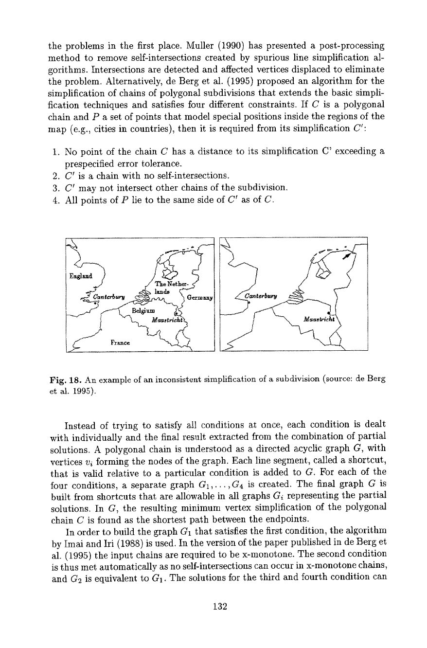
and present particular problems to basic line simplification algorithms (Fig. 18).
Weibel (1996) has attempted to identify the constraints that govern polygonal
subdivision simplification, proposing a typology of metric, topological, seman-
tic and GestMt constraints and reviewing relevant previous research. Two basic
alternatives exist to resolve problems such as the ones illustrated in Figure
18:
1) the problems are cleaned up in a post-processing operation or 2) the simpli-
fication algorithm incorporates the corresponding constraints and thus avoids
131
the problems in the first place. Muller (1990) has presented a post-processing
method to remove self-intersections created by spurious line simplification al-
gorithms. Intersections are detected and affected vertices displaced to eliminate
the problem. Alternatively, de Berg et al. (1995) proposed an algorithm for the
simplification of chains of polygonal subdivisions that extends the basic simpli-
fication techniques and satisfies four different constraints. If C is a polygonal
chain and P a set of points that model special positions inside the regions of the
map (e.g., cities in countries), then it is required from its simplification Ct:
1. No point of the chain C has a distance to its simplification C' exceeding a
prespecified error tolerance.
2. C' is a chain with no self-intersections.
3. C' may not intersect other chains of the subdivision.
4. All points of P lie to the same side of C 1 as of C.
/
Fig. 18. An example of an inconsistent simplification of a subdivision (source: de Berg
et al. 1995).
Instead of trying to satisfy all conditions at once, each condition is dealt
with individually and the final result extracted from the combination of partial
solutions. A polygonal chain is understood as a directed acyclic graph G, with
vertices v{ forming the nodes of the graph. Each line segment, called a shortcut,
that is valid relative to a particular condition is added to G. For each of the
four conditions, a separate graph G1,.,.,G4 is created. The final graph G is
built from shortcuts that are allowable in all graphs Gi representing the partial
solutions. In G, the resulting minimum vertex simplification of the polygonal
chain C is found as the shortest path between the endpoints.
In order to build the graph G1 that satisfies the first condition, the algorithm
by Imai and Iri (1988) is use& In the version of the paper published in de Berg et
al. (1995) the input chains are required to be x-monotone. The second condition
is thus met automatically as no self-intersections can occur in x-monotone chains,
and G2 is equivalent to G1. The solutions for the third and fourth condition can
132
be combined: Vertices of the chains of polygons adjacent to C are added to
point set P. G4 thus need not be established. Furthermore, only the points
falling inside the convex hull of the chain C being simplified could possibly end
up to the wrong side of C'. The actual number of candidate points in P can thus
be reduced further. The algorithm for determining consistent shortcuts (with
respect to the locations of points in P) leading to G3 is described in detail in de
Berg et al. (1995).
De Berg et al. (1995) have shown that their algorithm for simplifying a polyg-
onal subdivision with N vertices and M extra points runs in O (N (N + M) log N)
time in the worst case. Empirical studies with real data will need to establish
whether this close to quadratic time behavior actually shows up.
12 Methods for Structure and Shape Recognition
12.1 Motivation and Objectives
As Section 4 discussed, structure and shape recognition (i.e., cartometric eval-
uation) is logically prior to the application of generalization operators (Brassel
and Weibel 1988, McMaster and Shea 1992). Structure recognition allows to de-
termine when and where generalization needs to be applied and furnishes the
basis for the selection, sequencing, and parametrization of an appropriate set of
generalization operators for a given problem. Cartographic data often are rel-
atively unstructured. Entity definition in most spatial databases stops at the
level of individual map features; parts of features (e.g., a hairpin bend on a road
or an annex of a building) are rarely coded explicitly. Most spatial databases
also contain little semantic information in terms of the relative importance of
individual map objects - which is crucial in generalization since the purpose is
to distinguish between important and insignificant features. Finally, little infor-
mation is normally stored on shape properties of map features. The
objectives
of structure recognition
are therefore the following:
-
to structure the source data according to the requirements of the intended
generalization
- to 'enrich' the source data
- to derive secondary metric, topologic and semantic properties:
• metric: shape characteristics, density, distribution, object partitioning,
proximity relations
• topologic: topologic relations not represented in the source data
® semantic: relative importance (priority) of map objects, logical relations
between objects
12.2 Characterization and Segmentation of Cartographic Lines
Our first example of structure recognition is concerned with the analysis of linear
data. Since such a great share of cartographic data are of linear type, this task
133
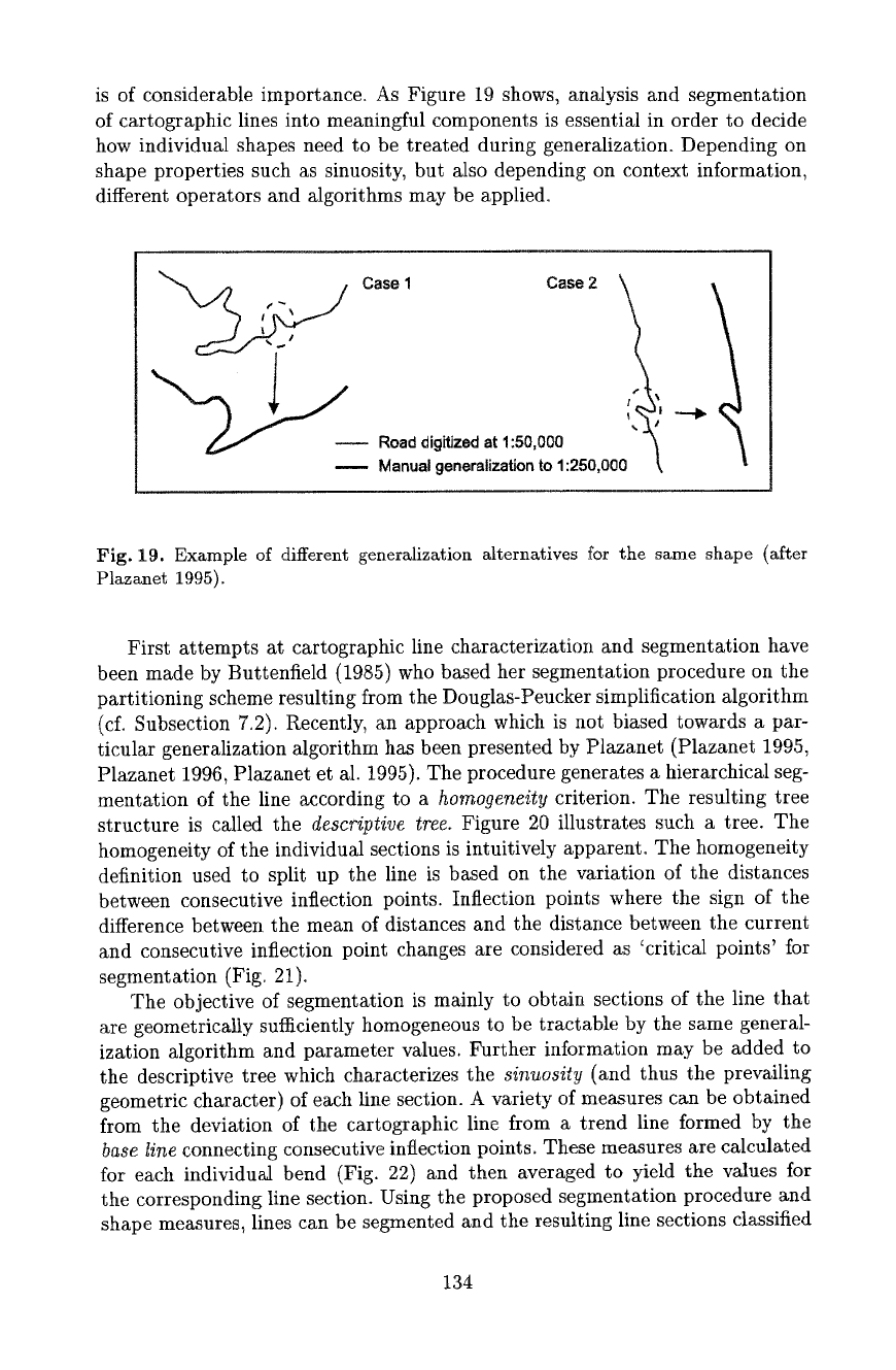
is of considerable importance. As Figure 19 shows, analysis and segmentation
of cartographic lines into meaningful components is essential in order to decide
how individual shapes need to be treated during generalization. Depending on
shape properties such as sinuosity, but also depending on context information,
different operators and algorithms may be applied.
Case 1 Case2 % 1
1 t ~
--
Road
digitized at 1:50,000 "~
Manual generalization to 1:250,000 ~,
Fig. 19. Example of different generalization alternatives for the same shape (after
Plazanet 1995).
First attempts at cartographic line characterization and segmentation have
been made by Buttenfield (1985) who based her segmentation procedure on the
partitioning scheme resulting from the Douglas-Peucker simplification algorithm
(cf. Subsection 7.2). Recently, an approach which is not biased towards a par-
ticular generMization algorithm has been presented by Ptazanet (Plazanet 1995,
Plazanet 1996, Plazanet et al. t995). The procedure generates a hierarchical seg-
mentation of the line according to a homogeneity criterion. The resulting tree
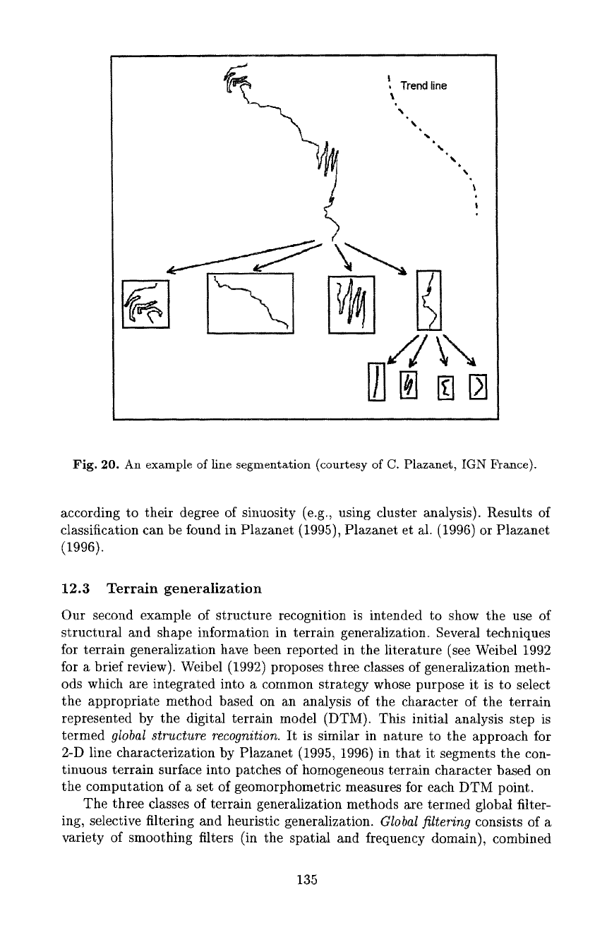
structure is called the descriptive tree. Figure 20 illustrates such a tree. The
homogeneity of the individual sections is intuitively apparent. The homogeneity
definition used to split up the line is based on the variation of the distances
between consecutive inflection points. Inflection points where the sign of the
difference between the mean of distances and the distance between the current
and consecutive inflection point changes are considered as 'critical points' for
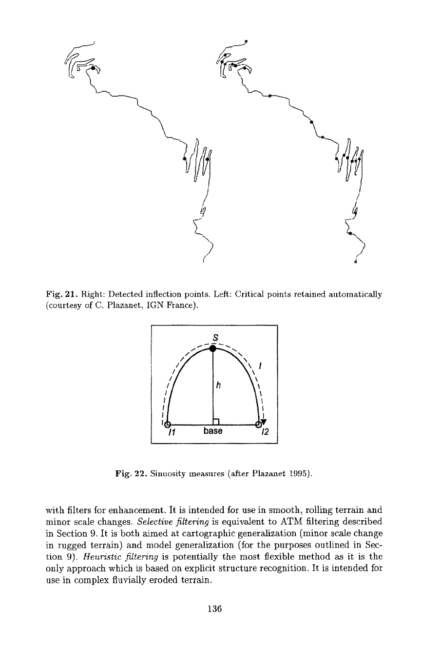
segmentation (Fig. 21).
The objective of segmentation is mainly to obtain sections of the line that
are geometrically sufficiently homogeneous to be tractable by the same general-
ization algorithm and parameter values. Further information may be added to
the descriptive tree which characterizes the sinuosity (and thus the prevailing
geometric character) of each line section. A variety of measures can be obtained
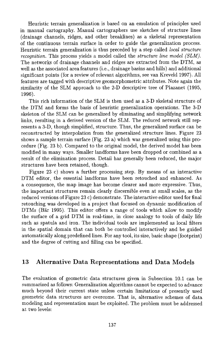
from the deviation of the cartographic line from a trend line formed by the
base line connecting consecutive inflection points. These measures are calculated
for each individual bend (Fig. 22) and then averaged to yield the values for
the corresponding line section. Using the proposed segmentation procedure and
shape measures, lines can be segmented and the resulting line sections classified
134
I Trend line
I
Fig. 20. An example of line segmentation (courtesy of C. Plazanet, IGN France).
according to their degree of sinuosity (e.g., using cluster analysis). Results of
classification can be found in Plazanet (1995), Plazanet et al. (1996) or Plazanet
(1996).
12.3 Terrain generalization
Our second example of structure recognition is intended to show the use of
structural and shape information in terrain generalization. Several techniques
for terrain generalization have been reported in the literature (see Weibel 1992
for a brief review). Weibel (1992) proposes three classes of generalization meth-
ods which are integrated into a common strategy whose purpose it is to select
the appropriate method based on an analysis of the character of the terrain
represented by the digital terrain model (DTM). This initial analysis step is
termed
global structure recognition.
It is similar in nature to the approach for
2-D line characterization by Plazanet (1995, 1996) in that it segments the con-
tinuous terrain surface into patches of homogeneous terrain character based on
the computation of a set of geomorphometric measures for each DTM point.
The three classes of terrain generalization methods are termed global filter-
ing, selective filtering and heuristic generalization.
Global filtering
consists of a
variety of smoothing filters (in the spatial and frequency domain), combined
135
f
Fig. 21. Right: Detected inflection points. Left: Critical points retained automatically
(courtesy of C. Plazanet, IGN France),
S
J
/1
!
base /2
Fig. 22. Sinuosity measures (after Plazanet 1995).
with filters for enhancement. It is intended for use in smooth, rolling terrain and
minor scale changes.
Selective filtering
is equivalent to ATM filtering described
in Section 9. It is both aimed at cartographic generMization (minor scale change
in rugged terrain) and model generalization (for the purposes outlined in Sec-
tion 9).
Heuristic filtering
is potentially the most flexible method as it is the
only approach which is based on explicit structure recognition. It is intended for
use in complex fluvially eroded terrain.
136
Heuristic terrain generalization is based on an emulation of principles used
in manual cartography. Manual cartographers use sketches of structure lines
(drainage channels, ridges, and other breaklines) as a skeletal representation
of the continuous terrain surface in order to guide the generalization process.
Heuristic terrain generalization is thus preceded by a step called local structure
recognition. This process yields a model called the structure line model (SLM).
The networks of drainage channels and ridges are extracted from the DTM, as
welt as the associated area features (i.e., drainage basins and hills) and additional
significant points (for a review of relevant algorithms, see van Kreveld 1997). Atl
features are tagged with descriptive geomorphometric attributes. Note again the
similarity of the SLM approach to the 2-D descriptive tree of Plazanet (1995,
1996).
This rich information of the SLM is then used as a 3-D skeletal structure of
the DTM and forms the basis of heuristic generalization operations. The 3-D
skeleton of the SLM can be generalized by eliminating and simplifying network
links, resulting in a derived version of the SLM. The reduced network still rep-
resents a 3-D, though simplified, structure. Thus, the generalized surface can be
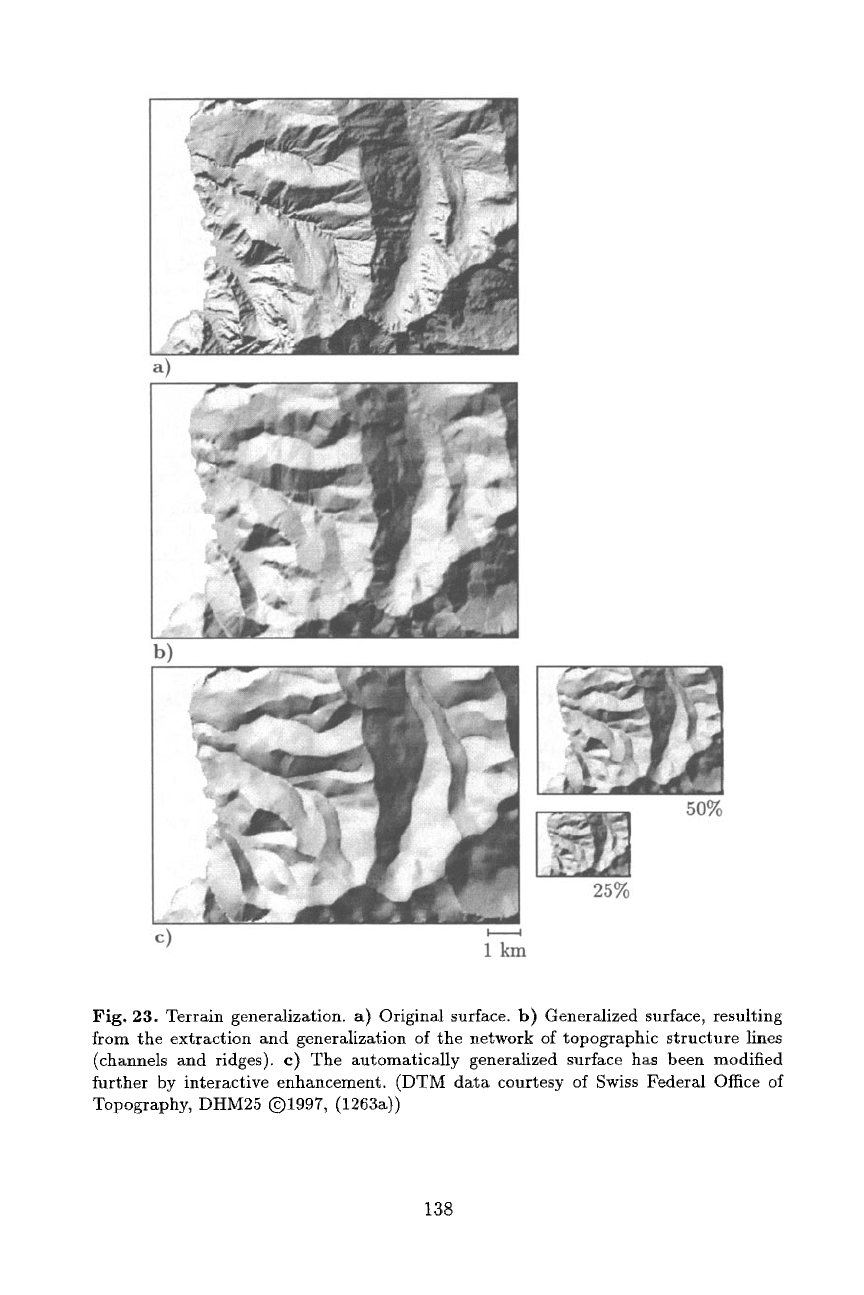
reconstructed by interpolation from the generalized structure lines. Figure 23
shows a sample terrain surface (Fig. 23 a) which was generalized using this pro-
cedure (Fig. 23 b). Compared to the original model, the derived model has been
modified in many ways. Smaller tandforms have been dropped or combined as a
result of the elimination process. Detail has generally been reduced, the major
structures have been retained, though.
Figure 23 c) shows a further processing step. By means of an interactive
DTM editor, the essential landforms have been retouched and enhanced. As
a consequence, the map image has become dearer and more expressive. Thus,
the important structures remain clearly discernible even at small scales, as the
reduced versions of Figure 23 c) demonstrate. The interactive editor used for final
retouching was developed in a project that focused on dynamic modification of
DTMs (B/tr 1995). This editor offers a range of tools which allow to modify
the surface of a grid DTM in real-time, in close analogy to tools of daily life
such as spatuta and iron. The individual tools are implemented as local filters
in the spatial domain that can both be controlled interactively and be guided
automatically along predefined lines. For any tool, its size, basic shape (footprint)
and the degree of cutting and filling can be specified.
13 Alternative Data Representations and Data Models
The evaluation of geometric data structures given in Subsection 10.1 can be
summarized as follows: Generalization algorithms cannot be expected to advance
much beyond their current state unless certain limitations of presently used
geometric data structures are overcome. That is, alternative schemes of data
modeling and representation must be exploited. The problem must be addressed
at two levels:
137
a)
b)
50%
25%
c) 1 km
Fig. 23. Terrain generalization, a) Original surface, b) Generalized surface, resulting
from the extraction and generalization of the network of topographic structure lines
(channels and ridges), c) The automatically generalized surface has been modified
further by interactive enhancement. (DTM data courtesy of Swiss Federal Office of
Topography, DHM25 Q1997, (1263a))
138
- Representations for geometric primitives:
Basic schemes available for the
representation of geometric primitives (points, lines, etc.). Examples of com-
monly used representations are the polygonal chain (or polyline), raster or
mathematical curves.
- Complex data models and data structures:
Complex data models allow to
integrate primitives into a common model and record their spatial and se-
mantic relations. Examples are the topological vector data model, but aux-
iliary data structures (uniform grid, quadtree, Delaunay triangulation, etc.)
are also of use in this context.
13.1 Representations for Geometric Primitives
In vector mode generalization, polygonal chains (polylines) are by far the most
commonly used scheme for representing geometric primitives. They are easy to
implement and handle, intuitive to understand and they can approximate any
desired shape accurately (provided the vertices are sampled sufficiently densely).
On the other hand, the polyline representation also imposes severe impediments
oll the development of generalization algorithms (Werschlein 1996, Fritsch and
Lagrange 1995). Allowable generalization operators are essentially restricted to
removing points (i.e., line simplification by vertex elimination) or displacing
points (i.e., line smoothing). The fact that a potyline is equivalent to a chain
(i.e., sequence) of points implies that it is difficult to model entire shapes in a
compact term.
The polyline representation certainly still has its merits in many general-
ization applications, but it should be extended by complementary representa-
tions. The work by Affholder on geometric modeling of road data (reported in
Plazanet et al. 1995) is an example of fitting the representation scheme more
closely to the object that needs to be represented. Road data are commonly
represented as polygonal chains, neglecting the fact that these man-made fea-
tures are constructed using mathematical curves rather than free-form chains
of points. Affholder models roads by a series of
cubic arcs,
leading to a more
compact and also more natural representation which offers potential for the de-
velopment of novel algorithms. For each bend of a road between two inflection
points, a pair of cubic arcs is used to approximate the left and right half of the
bend, respectively.
Other representations that bear potential for complementing polylines in a
useful way are parametric curve representations and wavelets. Curvature-based
curve parametrizations
can be usefully exploited for shape analysis since critical
points (such as inflection points) show up as extremes (Werschlein 1996). In
addition to that, the magnitude of these extremes also exhibits the size of the
shape associated with a critical point and thus allows to prioritize.
Wavelets
have potential for both shape analysis (Plazanet et at. 1995, Werschlein 1996)
and as a basis for novel generalization algorithms (Fritsch and Lagrange 1995,
Werschlein 1996). Wavelet coefficients can be analyzed to locate critical points
and shapes, and they can also be filtered yielding generalized versions of the
original feature. Since wavelets are localized, it is possible to eliminate entire
139
shapes by setting the coefficients of the wavelets supporting the shape to zero
(Werschlein 1996).
13.2 Complex Data Models
While the search for alternative representations for geometric primitives is mainly
guided by the requirements of shape representation and shape analysis, research
for improved complex data models is driven by the need to develop adequate
algorithms for the operators of
context-dependent generalization.
That is, data
models used for generalization must be extended to allow improved representa-
tion of spatial and semantic relations between individual features and feature
classes. The requirements for improved data models can be summarized as fol-
lows:
-
Representation of relevant metric, topological and semantic relations must
be possible between objects of the same feature class and across feature
classes. In particular, representation of proximity relations (metric) must be
improved.
- Object modeling:
® Multiple primitives per object (e.g., a coastline is partitioned into differ-
ent sections - sandy beach, estuary, rocky shore)
® Grouping (groups of objects of the same feature class), complex objects
® Shared primitives between objects of different feature classes
-
Integration of auxiliary data structures for computing and representing prox-
imity relations (triangulations, regular tessellations)
As a consequence of these requirements the main data model should be an
object-oriented extension of the basic topological vector model (as opposed to
layer-based). Data models of this kind are now beginning to appear in some
commercial GIS. Integrated auxiliary data structures for proximity relations
are not yet available in commercial systems, but research is under way in that
direction.
Most approaches to represent proximity relations between map objects have
concentrated on the use of Delaunay triangulations or Voronoi diagrams (Runs
1995, Runs and Plazanet 1996, Ware et al. 1995~ Jones et al. 1995, Ware and
Jones 1996). An example of the use of a regular triangular tessellation for line
generalization has been presented by Dutton (1996a). Dutton's quaternary trian-
gular mesh (QTM) scheme is interesting for a variety of reasons other than gener-
alization (outlined in Dutton 1996b). It offers a method for planetary geocoding
of both local and global geospatial data as an alternative to the traditional lat-
itude/longitude coordinate notation. Starting with an octahedron inscribed to
the globe, the eight faces of the octahedron are successively subdivided into
four equilateral triangles (and vertices projected to the surface of the globe),
yielding eight quadtree-like structures. Triangles are coded into 64-bit words.
A QTM location code (QTM ID) consists of an octant number (from 1 to 8)
followed by up to 30 quaternary digits (from 0 to 3) which name a leaf node
t40
