Van Kreveld M., Nievergelt J., Roos T., Widmayer P. (eds.) Algorithmic Foundations of Geographic Information Systems
Подождите немного. Документ загружается.

gorithms are possible for each operator. In particular, a wide range of different
algorithms exists for line simplification in vector mode (cf. Subsection 7.2).
5 Generalization - The Role of Algorithms
It should by now have become clear from the above discussion that generalization
is a complex process. What makes generalization so particularly hard to treat is
not only the complexity of geometric problems involved but also the fact that
the objectives are often ill-defined, owing to subjective, intuitive elements of
cartographic design. Note that this is not the case in model generalization (which
is non-graphical in nature), but it certainly holds for cartographic generalization
which forms the focus of this survey and also the major thrust of generalization
research.
So, what is the role of algorithms if we are trying to solve problems whose
objectives are so weakly defined? One consequence is that in terms of meeting
the functional objectives we may not expect to develop optimal algorithms, but
only plausible ones. Another effect is that algorithms are probably not the only
approach that should be used to tackle the problem comprehensively.
Knowledge-based methods are often mentioned as an alternative to algo-
rithms. Yet, a look at the history of research in cartographic generalization
reveMs that neither algorithmic methods (Lichtner 1979, Leberl 1986) nor know-
ledge-based techniques such as expert systems (Fisher and Macl~ness 1987, Nick-
erson 1988) have been capable of solving the problem comprehensively. While
the former suffered from a lack of flexibility (since they are usually designed to
meet a certain task) and from weak definition of objectives, the development
of the latter was impeded by the scarcity of formalized cartographic knowledge
and the problems encountered in acquiring it (Weibel et al. 1995). More re-
cent research has therefore concentrated on approaches that more closely follow
the decision support system (DSS) paradigm, a strategy often used to solve ill-
defined problems. A particular approach along this vein builds on the integration
of algorithmic and knowledge-based techniques and has been termed
amplified
intelligence
(Weibel 1991).
As visualization and generalization are essentially regarded as creative design
processes, the human is kept in the loop: key decisions default explicitly to the
user, who initiates and controls a range of algorithms that automatically carry
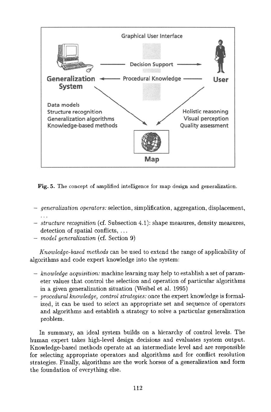
out generalization tasks (Fig. 6). Algorithms are embedded in an interactive
enviromnent and complemented by various tools for structure and shape recog-
nition giving cartometric information on object properties and clustering, spatial
conflicts and overlaps, and providing decision support to the user as well as to
knowledge-based components. Ideally, interactive control by the user reduces to
zero for tasks which have been adequately formalized and for which automated
solutions could be developed.
In such a setup,
algorithms
serve the purpose of implementing tasks for
which sufficiently accurate objectives can be defined:
111
Generalization
Graphical User Interface
= iill iiiii
Decision Support
Procedural Knowledge ~ User
Data models
"~ .....
/
Structure recognition "~ / Holist!c reasoning
Generalization algorithms ~ ,~ Visual perception
Knowledge-based methods P Quality assessment
Map
Fig. 5. The concept of amplified intelligellce for map design and generalization.
- generalization operators:
selection, simplification, aggregation, displacement,
- structure recognition
(cf. Subsection 4.1): shape measures, density measures,
detection of spatial conflicts, ...
- model generalization
(cf. Section 9)
Knowledge-based methods
can be used to extend the range of applicability of
algorithms and code expert knowledge into the system:
- knowledge acquisition:
machine learning may help to establish a set of param-
eter values that control the selection and operation of particular algorithms
in a given generalization situation (Weibel et al. 1995)
- procedural knowledge, control strategies:
once the expert knowledge is formal-
ized, it can be used to select an appropriate set and sequence of operators
and algorithms and establish a strategy to solve a particular generalization
problem.
In summary, an ideal system builds on a hierarchy of control levels. The
human expert takes high-level design decisions and evaluates system output.
Knowledge-based methods operate at an intermediate level and are responsible
for selecting appropriate operators and algorithms and for conflict resolution
strategies. Finally, algorithms are the work horses of a generalization and form
the foundation of everything else.
112
6 The Choice of Spatial Data Models - Raster or Vector?
Besides underlying theoretical principles and algorithms, spatial data models and
data structures form a third component of the foundation that allows to build
generalization methods. The choice of spatial data model has a great impact
on the way and completeness in which properties of real world objects can be
digitally represented and thus also directly governs the quality achievable by
algorithms that are developed on top of them (cf. Section 13).
It is common to distinguish two major classes of spatial data models avail-
able in GIS: tessellations, of which the raster model is the most widely used,
and vector models, in particular the topological vector model. The two classes of
data models represent quite different concepts of representing space. The raster
model, as a space-primary model, has advantages in representing continuously
varying phenomena (e.g., scalar fields) or regularly sampled categorical data
(e.g., landuse data derived fl'om remote sensing imagery), and it also eases the
computation of distance transformations. On the other hand, object representa-
tion is lost in raster models and severe discretization problems may be caused
by the tessellation structure. The vector model, as an object-primary model,
basically has reversed properties. It excels in its capabilities for object represen-
tation and accurate geometric coding, but it puts an additional burden on the
computation of proximity relations and makes it almost impossible to represent
continuous phenomena.
The debate over the advantages and disadvantages of raster vs. vector mod-
els has been one of the most persistent disputes in GIS research for many years.
It is therefore not surprising that the debate also affected generalization re-
search. Some authors have proposed to develop specific generalization operators
for raster models different from those for vector models (McMaster and Mon-
monier 1989). While the differences between the two forms of representation may
be considerable, it is not advisable, however, to depart from the conceptual hier-
archy of tasks, operators, and algorithms. It is possible to develop solutions for
all operators for both vector and raster models, although obviously some opera-
tors will be easier to implement for some data structures than others. The focus
should therefore be on the generalization tasks (what are the objectives that
the generalization has to meet?) and on the requirements of object representa-
tion (what data model adequately represents the structure and properties of the
given real world objects?). Given these requirements, a suitable set of operators
and algorithms then needs to be developed and applied, using the optimal data
model. In some situations this may be a raster model, in others a vector model
may be better suited. Most probably, complex problems will require a combina-
tion of different data models including auxiliary data structures, with functions
to convert between them. Section 12.3 presents an example of terrain generaliza-
tion which uses a combination of raster models to represent the terrain surface
and 3-D vector models to represent topographic structure lines. The two models
are converted into each other by object extraction and interpolation processes,
respectively.
113
For lack of space we will focus on methods based on vector data models in this
survey. Raster models are predominantly used in landuse generalization (since
most landuse databases are in raster format or derived from remote sensing
imagery) and as auxiliary representation to ease spatial search and distance
transformations (e.g., in object displacement). A review of raster-based methods
can be found in Schylberg (1993) and J~ger (1991).
7 Basic Algorithms - Context-Independent
Generalization
In this section, we will describe a few basic algorithms for three simple oper-
ators:
selection~elimination, simplification and smoothing.
These operators all
have in common that they are applied to individual objects independently of
their spatial context. For instance, objects that are close to a line that is sim-
plified may be affected (e.g., the new line may overlap with them), but the
simplification process really only relates to the line object. This kind of gener-
alization can be termed
context-independent generalization.
In contrast to
that,
context-dependent generalization
involves operators such as aggrega-
tion or displacement which can only be triggered and controlled following an
analysis of the spatial context (spatial relations of objects, object density, etc.).
Context-dependent operators will only be described in Sections 11 to 13.
7.1 Object Selection/Elimination
Object selection (or defined by the antonym, object elimination) may be a simple
operator, but is also an effective one as it makes space available on the map by
omitting objects that are deemed irrelevant for the target map. Three questions
must be addressed:
- How many objects are selected?
- Which objects are selected?
-
What constraints govern the selection process?
Commonly, however, objects are not only omitted but the remaining objects
are also repositioned in order to maintain the visual impression of the original
arrangement of objects on the source map. Object selection thus most often only
represents a first step of a series of operations.
Number of objects. The first of the above questions has been addressed in the
1960s by TSpfer and his co-workers (T5pfer 1974). Empirical rules were estab-
lished in extensive studies involving the comparison of published map series. The
basic empirical principle derived from these studies was termed the 'Principle of
Selection' or 'Radical Law' (in German:
'Wurzelgesetz~:
ST =nS (1)
114
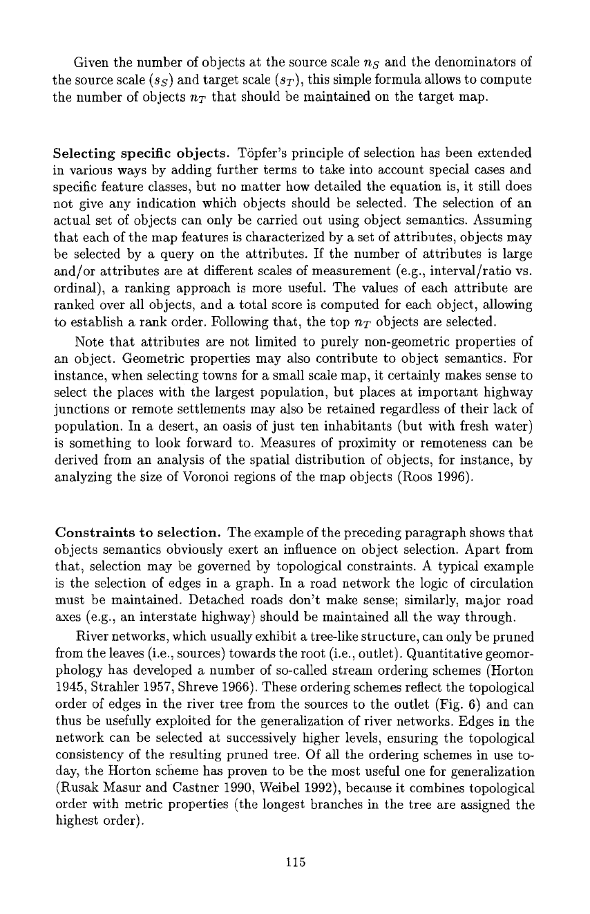
Given the number of objects at the source scale ns and the denominators of
the source scale (ss) and target scale
(sT),
this simple formula allows to compute
the number of objects
nT
that should be maintained on the target map.
Selecting specific objects. TSpfer's principle of selection has been extended
in various ways by adding further terms to take into account special cases and
specific feature classes, but no matter how detailed the equation is, it still does
not give any indication whiSh objects should be selected. The selection of an
actual set of objects can only be carried out using object semantics. Assuming
that each of the map features is characterized by a set of attributes, objects may
be selected by a query on the attributes. If the number of attributes is large
and/or attributes are at different scales of measurement (e.g., interval/ratio vs.
ordinal), a ranking approach is more useful. The values of each attribute are
ranked over all objects, and a total score is computed for each object, allowing
to establish a rank order. Following that, the top
nT
objects are selected.
Note that attributes are not limited to purely non-geometric properties of
an object. Geometric properties may also contribute to object semantics. For
instance, when selecting towns for a small scale map, it certainly makes sense to
select the places with the largest population, but places at important highway
junctions or remote settlements may also be retained regardless of their lack of
population. In a desert, an oasis of just ten inhabitants (but with fresh water)
is something to look forward to. Measures of proximity or remoteness can be
derived from an analysis of the spatial distribution of objects, for instance, by
analyzing the size of Voronoi regions of the map objects (Roos 1996).
Constraints to selection. The example of the preceding paragraph shows that
objects semantics obviously exert an influence on object selection. Apart from
that, selection may be governed by topological constraints. A typical example
is the selection of edges in a graph. In a road network the logic of circulation
must be maintained. Detached roads don't make sense; similarly, major road
axes (e.g., an interstate highway) should be maintained all the way through.
River networks, which usually exhibit a tree-like structure, can only be pruned
from the leaves (i.e., sources) towards the root (i.e., outlet). Quantitative geomor-
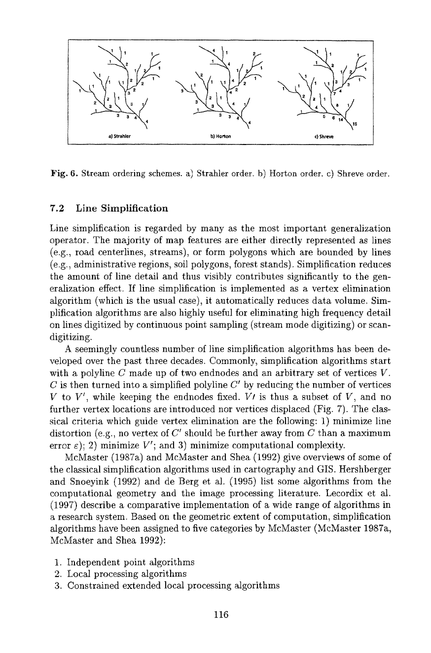
phology has developed a number of so-called stream ordering schemes (Horton
1945, Strahler 1957, Shreve 1966). These ordering schemes reflect the topological
order of edges in the river tree from the sources to the outlet (Fig. 6) and can
thus be usefully exploited for the generalization of river networks. Edges in the
network can be selected at successively higher levels, ensuring the topological
consistency of the resulting pruned tree. Of all the ordering schemes in use to-
day, the Horton scheme has proven to be the most useful one for generalization
(Rusak Masur and Castner 1990, Weibel 1992), because it combines topological
order with metric properties (the longest branches in the tree are assigned the
highest order).
115
1 , ! ~ 1 t 1 1 1
1 1 1 2 2 1 1 1 4 2 1 1 1 1 3 4 3
2 1 2 1 7 B 1
3 3 4 1 4
a) Strahler b) Horton c)
Shreve
Fig. 6. Stream ordering schemes, a) Strahler order, b) Horton order, c) Shreve order.
7.2 Line Simplification
Line simplification is regarded by many as the most important generalization
operator. The majority of map features are either directly represented as lines
(e.g., road centerlines, streams), or form polygons which are bounded by lines
(e.g., administrative regions, soil polygons, forest stands). Simplification reduces
the amount of line detail and thus visibly contributes significantly to the gen-
eralization effect. If line simplification is implemented as a vertex elimination
algorithm (which is the usual case), it automatically reduces data volume. Sim-
plification algorithms are also highly useful for eliminating high frequency detail
on lines digitized by continuous point sampling (stream mode digitizing) or scan-
digitizing.
A seemingly countless number of line simplification algorithms has been de-
veloped over the past three decades. Commonly, simplification algorithms start
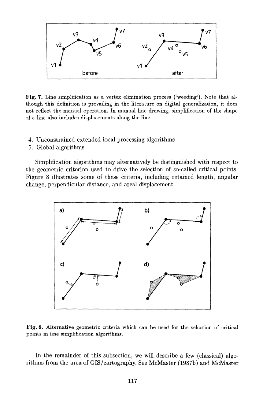
with a polytine C made up of two endnodes and an arbitrary set of vertices V.
C is then turned into a simplified polyline C r by reducing the number of vertices
V to V t, while keeping the endnodes fixed. V/ is thus a subset of V, and no
further vertex locations are introduced nor vertices displaced (Fig. 7). The clas-
sical criteria which guide vertex elimination are the following: 1) minimize line
distortion (e.g, no vertex of C r should be further away from C than a maximum
error c); 2) minimize Vr; and 3) minimize computational complexity.
McMaster (1987a) and McMaster and Shea (1992) give overviews of some of
the classical simplification algorithms used in cartography and GIS. Hershberger
and Snoeyink (1992) and de Berg et al. (1995) list some algorithms from the
computational geometry and the image processing literature. Lecordix et al.
(1997) describe a comparative implementation of a wide range of algorithms in
a research system. Based on the geometric extent of computation, simplification
algorithms have been assigned to five categories by McMaster (McMaster 1987a,
McMaster and Shea 1992):
1. Independent point algorithms
2. Local processing algorithms
3. Constrained extended local processing algorithms
116
v3
f
v7
V2~v6
vl ~ -v5
before
v3j~__.~._~ v7
vlV2/ v4 °Ov5 " v
TM
6
after
Fig. 7. Line simplification as
a
vertex elimination process ('weeding'). Note that al-
though this definition is prevailing in the literature on digital genera~zation, it does
not reflect the manual operation, tn manual line drawing, simplification of the shape
of a line also includes displacements along the line.
4. Unconstrained extended local processing algorithms
5. Global algorithms
Simplification algorithms may alternatively be distinguished with respect to
the geometric criterion used to drive the selection of so-called critical points.
Figure 8 illustrates some of these criteria, including retained length, angular
change, perpendicular distance, and areal displacement.
b) o
Fig. 8. Alternative geometric criteria which can be used for the selection of critical
points in line simplification Mgorithms.
In the remainder of this subsection, we will describe a few (classical) algo-
rithms from the area of GIS/cartography. See McMaster (1987b) and McMaster
117
and Shea (1992) for details on related algorithms. The following discussion to
some extent also reflects the historical evolution of line simplification techniques.
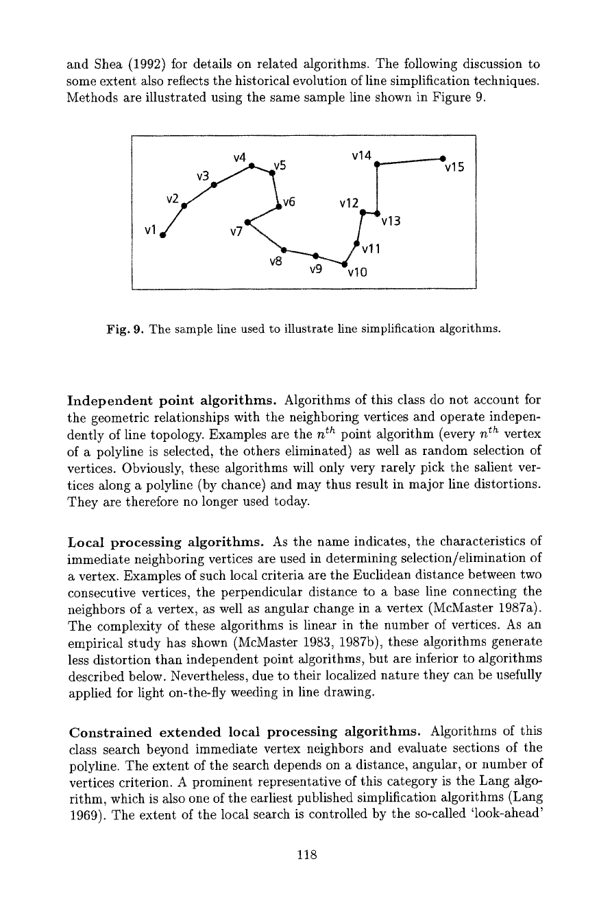
Methods are illustrated using the same sample line shown in Figure 9.
5 Vl4T-~vl 5
V12e. ~
vl v7 J -v13
v8
vg~v ir~ II
Fig. 9. The sample line used to illustrate line simplification algorithms.
Independent point algorithms. Algorithms of this class do not account for
the geometric relationships with the neighboring vertices and operate indepen-
dently of line topology. Examples are the n th point algorithm (every
n r:h
vertex
of a polyline is selected, the others eliminated) as well as random selection of
vertices. Obviously, these algorithms will only very rarely pick the salient ver-
tices along a polyline (by chance) and may thus result in major line distortions.
They are therefore no longer used today.
Local processing algorithms. As the name indicates, the characteristics of
immediate neighboring vertices are used in determining selection/elimination of
a vertex. Examples of such local criteria are the Euclidean distance between two
consecutive vertices, the perpendicular distance to a base line connecting the
neighbors of a vertex, as well as angular change in a vertex (McMaster 1987a).
The complexity of these algorithms is linear in the number of vertices. As an
empirical study has shown (McMaster 1983, 1987b), these algorithms generate
tess distortion than independent point algorithms, but are inferior to algorithms
described below. Nevertheless, due to their localized nature they can be usefully
applied for light on-the-fly weeding in line drawing.
Constrained extended local processing algorithms. Algorithms of this
class search beyond immediate vertex neighbors and evaluate sections of the
polyline. The extent of the search depends on a distance, angular, or number of
vertices criterion. A prominent representative of this category is the Lang algo-
rithm, which is also one of the earliest published simplification algorithms (Lang
1969). The extent of the local search is controlled by the so-called 'look-ahead'
118
parameter in this algorithm; the amount of filtering is governed by a perpendic-
ular distance tolerance ~. Thus, the Lang algorithm is frequently assigned to a
class of algorithms termed
tolerance band algorithms or bandwidth algo-
rithms,
along with other algorithms utilizing a perpendicular distance tolerance
to a base line (e.g., Douglas and Peucker 1973, Reumann and Witkam 1974, or
Opheim 1982).
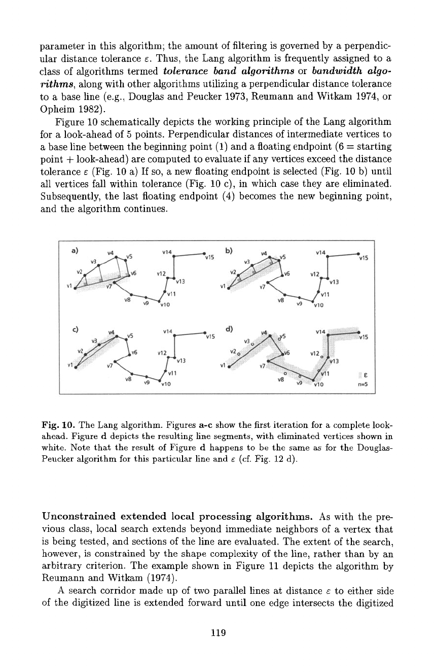
Figure 10 schematically depicts the working principle of the Lang algorithm
for a look-ahead of 5 points. Perpendicular distances of intermediate vertices to
a base line between the beginning point (1) and a floating endpoint (6
=
starting
point + look-ahead) are computed to evaluate if any vertices exceed the distance
tolerance e (Fig. 10 a) If so, a new floating endpoint is selected (Fig. 10 b) until
all vertices fall within tolerance (Fig. 10 c), in which case they are eliminated.
Subsequently, the last floating endpoint (4) becomes the new be~nning point,
and the algorithm continues.
a) ,.,4 _ vt 4 ~ b) v4 . vs v14 ~-'-~v
v3 ~ _v :)v5 vl 2 ~ v 15 v3 . v6 15
vl j -v13 v12e-'~
v8 ~"~vlO v8 ~"~vl~ 11
v3~ : i " v6 vl 2e.j,T-~vl 5
v8 v9 vlO
Fig. 10. The Lang algorithm. Figures a-c show the first iteration for a complete look-
ahead. Figure d depicts the resulting line segments, with eliminated vertices shown in
white. Note that the result of Figure d happens to be the same as for the Douglas-
Peucker algorithm for this particular fine and e (cf. Fig. 12 d).
Unconstrained extended local processing algorithms. As with the pre-
vious class, local search extends beyond immediate neighbors of a vertex that
is being tested, and sections of the line are evaluated. The extent of the search,
however, is constrained by the shape complexity of the line, rather than by an
arbitrary criterion. The example shown in Figure ii depicts the algorithm by
Reumann and Witkam (1974).
A search corridor made up of two parallel lines at distance ~ to either side
of the digitized line is extended !brward until one edge intersects the digitized
119
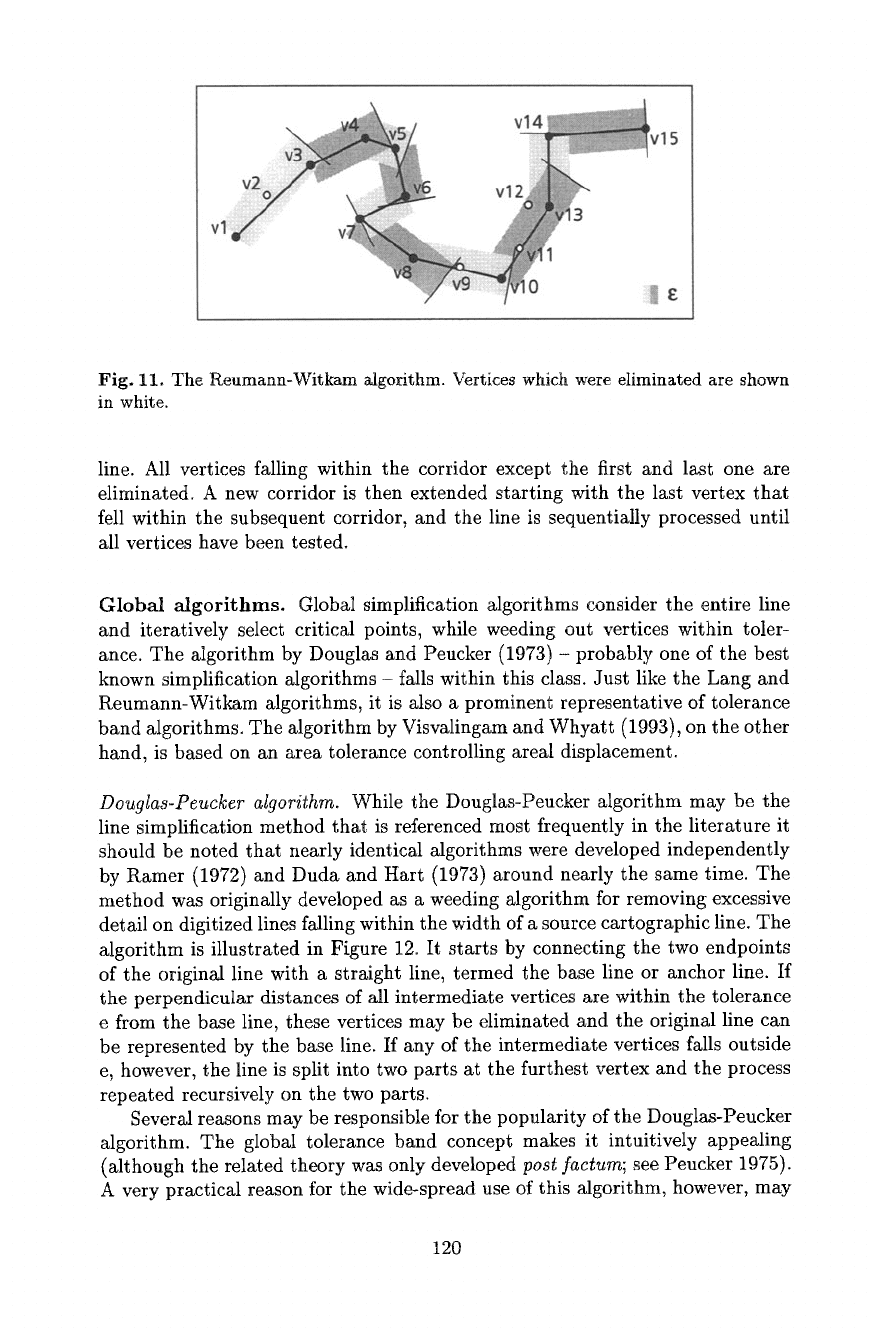
Fig. 11. The Reumann-Witkam algorithm. Vertices which were eliminated are shown
in white.
line. All vertices falling within the corridor except the first and last one are
eliminated. A new corridor is then extended starting with the last vertex that
fell within the subsequent corridor, and the line is sequentially processed until
all vertices have been tested.
Global algorithms. Global simplification algorithms consider the entire line
and iteratively select critical points, while weeding out vertices within toler-
ance. The algorithm by Douglas and Peucker (1973) - probably one of the best
known simplification algorithms - falls within this class. Just like the Lung and
Reumann-Witkam algorithms, it is also a prominent representative of tolerance
band algorithms. The algorithm by Visvalingam and Whyatt (1993), on the other
hand, is based on an area tolerance controlling areal displacement.
Douglas-Peucker algorithm.
While the Douglas-Peucker algorithm may be the
line simplification method that is referenced most frequently in the literature it
should be noted that nearly identical algorithms were developed independently
by Ramer (1972) and Duda and Hart (1973) around nearly the same time. The
method was originally developed as a weeding algorithm for removing excessive
detail on digitized lines falling within the width of a source cartographic line. The
algorithm is illustrated in Figure 12. It starts by connecting the two endpoints
of the original line with a straight line, termed the base line or anchor line. If
the perpendicular distances of all intermediate vertices are within the tolerance
e from the base line, these vertices may be eliminated and the original line can
be represented by the base line. If any of the intermediate vertices falls outside
e, however, the line is split into two parts at the furthest vertex and the process
repeated recursively on the two parts.
Several reasons may be responsible for the popularity of the Donglas-Peucker
algorithm. The global tolerance band concept makes it intuitively appealing
(although the related theory was only developed
post factum;
see Peucker 1975).
A very practical reason for the wide-spread use of this algorithm, however, may
120
