Potter T.D., Colman B.R. (co-chief editors). The handbook of weather, climate, and water: dynamics, climate physical meteorology, weather systems, and measurements
Подождите немного. Документ загружается.

Maintenance includes preventive and corrective actions. A solid preventive main-
tenance program can preclude a large portion of equipment failure events. Corrective
maintenance should be applied as promptly as possible to minimize downtime,
provided that proper documentation is made of the failure symptoms or condition
and that the replacement or repaired equipment is properly tested when installed.
Data Processing
Data processing begins during the measurement phase of the program; sensor
responses are translated to a numerical value that can be averaged, totaled, stored
as an extreme, or used to calculate a variance about the mean. Modern data recording
equipment offers the user numerous options, as well as pitfalls. As with other
activities, proper testing and documentation of the on-site processing routines is
an essential first step in demonstrating that data processing is correctly applied.
Most programs are enhanced by including data-identifier information with all data
records, so that raw files can be uniquely identified by time period and station
location. Once the data are collected from the field station, the data should be
traceable throughout the data validation and editing processes.
Audits
An important step in demonstrating data credibility to outside groups is to document
the results of independent verifications of compliance with established procedures
and tolerance limits. The term performance audit implies tests made by knowledge-
able staff independent of those performing the routine site operations and checks
using independent testing equipment, which is also traceable to standards. The
complementary function is a system audit, in which independent staff examine the
work products and docum entation to ensure that activities comply with the estab-
lished procedures.
Reports
The final link in the chain of demonstrating data quality is to produce credible
reports of the monitoring program results. Report content and format should fit
the objectives of the program. It is wise to include summaries of the quality control
and quality assurance activities in sufficient detail that the results can be accepted.
REFERENCES
American Nuclear Society (1984). ANSI=ANS-2.5: Standard for Determining Meteorological
Information at Nuclear Power Sites, American Nuclear Society.
American Nuclear Society (2000). ANSI=ANS-3.11: Determining Meteorological Information
at Nuclear Facilities, American Nuclear Society.
Slade, D. H. (Ed.) (1968). Meteorology and Atomic Energy, U.S. AEC, July.
866
REGULATORY APPROACHES TO QUALITY ASSURANCE AND QUALITY CONTROL
U.S. EPA (1994). Quality Assurance Handbook for Air Pollution Measurement Systems,
Vol. IV: Meteorological Measurements, U.S. EPA Office of Research and Development,
Washington, DC, EPA=600=R-95-038d, April.
U.S. EPA (2000). Meteorological Monitoring Guidance for Regulatory Modeling Applications,
U.S. EPA Office of Air Quality Planning and Standards, Research Triangle Park, NC,
EPA-454=R-99-005, February.
REFERENCES 867

CHAPTER 46
MEASURING GLOBAL TEMPERATURE
JOHN R. CHRISTY
Every part of the Earth system may be described by the variable of state we call
temperature. Fundamentally, temperature is the magnitude of the average molecular
kinetic energy of a substance—the higher the molecule’s average speed, the greater
the temperature. Today, temperature is estimated by several kinds of instruments
using a variety of techniques.
In situ measurements require, in some way, direct contact between the instrument
and the moving molecules of the targeted substance. The most familiar of these types
of instruments is the liquid-in-glass ther mometer whose bulb contains a liquid that
expands or contracts, allowing the liquid to move through an opening to a narrow,
graduated tube. The bulb is inserted into the medium of interest (e.g., air, water, ice,
or earth) and the liquid responds according to the amount of molecular motion
detected on contact. Another in situ device utilizes the fact that the electrical resis-
tance of a conductor is proportional to its molecular kinetic energy so that the
amount of electricity able to flow throu gh the conductor indicates temperature.
The velocity of sound through a substance (usually air or water) is also directly
related to its temperature and thus is an indirect characteristic that can be used to
monitor temperature in situ.
Remote met hods, in contrast to in situ, have the advantage of measuring tempera-
ture from a distance. The most direct of these methods employs radiometers that
measure the intensity of radiation emitted by a substance. The magnitude of the
intensity is often proportional to the substance’s temperature. Satellite radiometers
fall into this category of devices as they monitor the upwelling radiation from the
various components of Earth’s system. Other relatively new remotely sensed meth-
ods estimate temperature by measuring (a) the speed and refraction of radio signals
through a material (e.g., Global Positioning System satellites), (b) the physical
Handbook of Weather, Climate, and Water: Dynamics, Climate, Physical Meteorology, Weather Systems,
and Measurements, Edited by Thomas D. Potter and Bradley R. Colman.
ISBN 0-471-21490-6 # 2003 John Wiley & Sons, Inc.
869
height of the sea surface (higher altitudes mean expanded or warmer water) and even
the thermal ‘‘color’’ of the ocean affected by microorganisms that preferentially
appear in waters of certain temperatures.
The distinction between in situ and remo te may be rather blurred. One thinks of a
bucket dropped over the side of a ship, filled with seawater, hoisted back up on deck
into which a thermometer is inserted, and from which a temperature reading is
determined after some time as in situ. However, one probably thinks of a satellite
radiometer, which measures the actual, unaltered photons representing the exact
character of the substance in question and traveling at the speed of light, as a
remote measurement. One can see that mere proximity to the intended medium
may not assure the most accurate estimate of temperature.
A unique and quasi-direct method is one that measures the temperature at various
depths of a very stable borehole (e.g., in bedrock or ice cap) and then estimates what
the surface temperature would have been in the past to produce the temperatures
observed at each given depth. Simply put, the deeper the temperature reading, the
longer in the past it was influenced by the surface temperature.
Temperatures from all of the above devices are referred to as being part of the
‘‘instrumental’’ record and in some sense may be called direct measurements. There
are, however, several indirect methods available in which some organism or physical
process preserves in its histo ry the character of the environmental factors, including
temperature, affecting it. In this category of ‘‘proxy’’ records are tree rings, ice core
composition and thickness, isotope ratios in ice, sea floor, and sediment cores, pollen
distributions in sediments, erosion rates, coral bands, sea level height, evidence of
the extent of mountain glaciation, plant and animal fossil types and distributions, and
many more. With these types of proxy and borehole records, some estimates of the
climate prior to the instrumental record are possible.
The global temperature is a rather ambiguous term since every part of the global
system has its own temperature. When used in the context of clim ate change, it
usually means the temperature of Earth’s atmosphere about a meter or two above the
surface, often termed near-surface air temperature. However, one could speak of
the temperature of the land itself, or of the sea water at various depths, or of the ice in
the ice caps, or of the atmosphere at any of several altitudes. It is even possible to
measure the temperature of the ‘‘cold space’’ in which Earth orbits and find a value
of about 2.7 K. Because Earth is a syst em of many interactive components, the
temperature of each is truly necessary to document global temperature.
Most data sets of global temperature are in fact not global in extent nor systematic
in quantity measured. So, not only are there variations in ‘‘how’’ and ‘‘where’’
temperature is measured, one must be careful to know ‘‘what’’ aspect of the Earth
system is being measured. Because we as humans experience weather and sustain
our existence on the surface of this planet, the near-surface air temperature is usually
the quantity of first importance to us.
For all of the temperature data sets above and to which the term global is applied,
there are issues of uncertainty—spatial and temporal homogeneity, calibration
(or lack thereof ) of sensors and techniques, changes in instrumentation (type,
method etc.), degradation of instruments over time, corruption of proxies over
870 MEASURING GLOBAL TEMPERATURE
time, changes in local environment due to nonclimatic factors, poor infor mation on
observational practices, and many others. Each of these present potential problems
and are usually difficult to assess so that the total level of uncertainty in any
measurement is not completely quantifiable. In the attempt to understand precisely
what the climate system is doing in terms of temperature, the unpleasant notion of
potential error is never totally absent.
The various measures of global temperature have been described in publications
too numerous to list. The four Intergovernmental Panel on Climate Change reports
(IPCC, 1990, 1992, 1996, 2001) are probably the best sources of information that
document the more prominent data sets.
1 PROXY RECORD OF SURFACE TEMPERATURES
The average of proxy-estimated temperatures of widely scattered sites prior to instru-
mental record gives a rough idea of what the temperature may have been in the past.
One set of these time series is shown in Figure 1 (see also IPCC, 1990, Fig. 7.1). Even
in these very low time-resolution diagrams, there is clear evidence of large variability
in global temperatures. Fluctuations in volcanism, solar insolation, orbital para-
meters, atmospheric composition (including changes due to human activities),
aerosols, natural chaos, etc. certainly play their roles, sometimes in isolation and at
other times in interdependent ways, as probable explanations for the variations.
Efforts have been attempted to quantify these causes, usually by a combination of
empirical calibration and analytical theory (e.g., Mann et al., 1998; Tett et al., 1997;
Wigley and Raper, 1990), but such discussion is not the focus of this chapter.
Figure 1 (top) shows two periods of interglacial (warm) temperatures over the
past 150,000 years, the current being the Holocene that began over 10,000 years ago.
The mid-Holocene ( 6000 years ago) was relatively warm as was the period about
1000 years ago (Fig. 1, middle and lower). There is considerable evidence that the
period between 1400 and 1850 was somewhat cool and is commonly called the Little
Ice Age, though recent evidence suggests that it was a period of several types of
climate fluctuations in various parts of the globe. Solar variability and significant
volcanism are among those forcing parameters thought to play roles in causing these
‘‘recently’’ depressed temperatures.
2 INSTRUMENTAL RECORD OF SURFACE TEMPERATURES
For most of the instrumental period, the past 150 years or so, temperature has been
determined from the familiar liquid-in-glass thermometers housed in various types
of shelters, usually 1.5 m above the ground, around the world’s land areas. Over the
oceans, the sea surface temperature (or SST, i.e., the temperature of the seawater, not
the air) is the preferred quantity because of the ocean’s more spatially and temporally
coherent temperature field. The manner by which the SSTs are measured has varied
considerably through the years and requires careful adjustment factors to account for
2 INSTRUMENTAL RECORD OF SURFACE TEMPERATURES 871
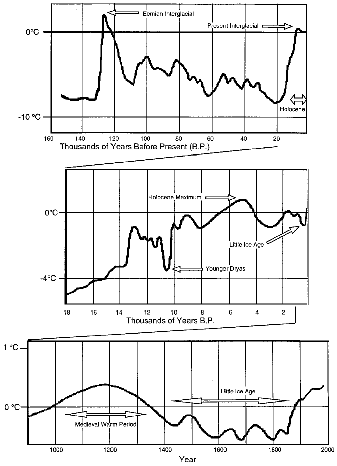
Figure 1 Estimates of global temperature variations over three long periods ending with the
present day determined from proxy information (EarthQuest, Office of Interdisciplinary Earth
Studies, Spring 1991, Vol. 5, p. 1).
872
MEASURING GLOBAL TEMPERATURE
biases introduced when, for example, buckets or ship- intake values are used
(Folland and Parker, 1995). The ‘‘global’’ temperature most commonly reported is
a combination of the near-surface air over land and SST reports over oceans,
however geographically sparse they might be.
Only a handful of serious efforts have achieved the goal of collecting as many
reports as are presently accessible to document the temperature in several places
around the globe over the past 150 years. (Scattered records go back further, one to
the midseventeenth century in central Eng land; see Manley, 1974.) The IPCC
usually focuses on the data sets produced by (1) the Climate Research Unit of the
University of East Anglia (near-surface air temperature over land; Jones and Briffa,
1992), (2) UK Meteorological Office (SSTs; Parker et al., 1995), (3) Goddard
Institute for Space Studies, NASA (near-surface air temperature over land; Hansen
and Lebedeff, 1988), (4) Russian (near-surface air temperature over land, Vinnikov
et al., 1990), and (5) NOAA satellite-based SSTs (Reynolds and Smith, 1995). Two
other significant efforts are the Global Historical Climate Network (NOAA=NCDC;
Vose et al., 1995) and a database of individual SST reports known as COADS
(Woodruff et al., 1987). At present, some of these groups are combining the data
sets of temperatures over land with SSTs to produce global coverage (e.g., IPCC,
1996; Hansen et al., 1996).
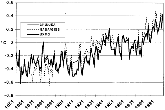
The time series of global, annual surface temperature anomalies for three of the
groups is displayed in Figure 2. (All of the time series produced from the various
groups are quite similar, and this is to be expected since the critical broad variations
depend on basically the same primary source data for each data set.) These time
Figure 2 Annual, global anomalies of surface temperature 1851–1997 as a combination of
near-surface air temperatures over land and SSTs over oceans (CRU=UEA, UKMO) and land-
only (NASA=GISS).
2 INSTRUMENTAL RECORD OF SURFACE TEMPERATURES 873
series were described in the IPCC (1996) as showing a 0.3 to 0.6
C rise over the past
century, the range being due to the uncertainty factors mentioned above.
The features of this time series are well-known; a fairly significant rise from about
1910 to 1940 (0.4
C), then somewhat random variations to 1980 and a rise since
that time (an additional 0.2
C). A comparison of the most recent 30 years with
those of 1870–1899 reveal an incre ase in temperature of about 0.4
C while a
comparison of the most recent 10 years versus the earliest 10 (1860–1 869) shows
a rise of about 0.6
C.
3 BOREHOLE TEMPERATURES
An insulated, homogeneous column of material with one end exposed to temperature
variations over a long period will reveal temperature variations throughout the
column according to the speed at which the fluctuations propagate from the exposed
end. An analysis of the temperatures throughout the column at a given point in time,
then, may contain enough information to recover those external temperature varia-
tions. The general idea is that the greater the depth from the exposed end, the further
back in time the temperature at that depth might represent. Of course, as time passes,
the perturbations tend to smear, and it becomes difficult to extract meaningful
information about what may have happened at the surface.
Certain types of stable, homogeneous bedrock and large ice plateaus lend them-
selves to temperature recovery through measurements taken in boreholes. The theory
and complications regarding the inversion of the temperature profiles into time series
are quite complex, but the general results show that many land regions have experi-
enced warming in the past three centuries, though the results show variations among
the individual sites (Deming, 1995). Also, evidence from boreholes on the Green-
land Plateau suggest that the period around 1000 years ago was warmer than the
present century (Cuffey et al., 1994; Dahl-Jensen et al., 1997). Both of these results
are consistent with the temperature estimates in Figure 1.
4 UPPER AIR TEMPERATURES
Upper air measurements, which could be compiled into large-scale averages, became
possible in the late 1950s due to the expansion of the network of radiosonde
stations—sites that release balloon-borne instruments to measure temperature,
wind, and humidity to altitudes up to and exceeding 10 km. Sources of large-scale
averages of temperatures at various levels and for various layers have been provided
by NOAA (Angell, 198 8; 63 stations; Oort and Liu, 1993; 800þ stations), UK
Meteorological Office (UKMO) (Parker et al., 1997; 350þ stations), and Russian
IHMI-WDC (Sterin et al., 1997; 800þ stations).
Temperature time series constructed from individual radiosonde sites often
display inhomogeneities most often related to changes in the instrumentation or
874 MEASURING GLOBAL TEMPERATURE
the algorithms by which the raw data are processed into pressure-level data (Gaffen,
1994). These inhomogeneities can be quite prominent at the highest elevations
because errors or changes tend to accumulate as the balloon ascends. Oort and
Liu (1993) generate global maps by object ive analysis of their world-wide radio-
sonde dataset. The UKMO product uses selected stations with better records of
homogeneity and length and produce s a quasi-global analyses with limited inter-
polation for filling in vacant grids. As with Oort and Liu (1993), the RIHMI-WDC
produces global analyses by objective means but also applies a complex quality
control algorithm to the data to remove obvious inconsistencies that viola te
hydrostatic constraints and those of spatial coherency.
Since 1979, nine NOAA polar orbiting satellites have carried an instrument, the
microwave sounding unit, or MSU, designed to provide temperature information in
both clear and cloudy areas where infrared (IR) methods are ineffective. The sensor
measures the intensity of radiation near the 60-GHz oxygen absorption band, which
is proportional to atmospheric temperature. Though not intended to provide long-
term climate information, data from the nine MSUs, which have orbited since 1979,
have been calibrated and merged into a single time series (Christy et al., 1995). With
daily global coverage (over 30,000 observations per day) of a very robust quantity
(a volume of air over 50,000 km
3
per observation), these data have some advantages
over other types of data sets.
Two MSU temperature products are widely used: the lower troposphere (the
average temperature of the surface to about 7 km or 1000 to 400 hPa) and the
lower stratosphere (17 to 22 km layer or about 120 to 70 hPa). Version D of the
data described in Christy et al. (2000) takes into account recently discovered influ-
ences on the satellites that affect the observations.
We have found in the several years of constructing the MSU data sets that the
issues of greatest impact on the long-term record are (1) the intersatellite biases, (2)
the orbital time drift, and (3) the orbit decay (see Wentz and Schabel, 1998). Because
the MSU data sets are products we produce, I shall devote a relatively large amount
of discussion to them.
Though calibrated to high precision on Earth in thermally controlled vacuum
chambers, the MSU, once in the environment of space, may acquire or display
unexpected characteristics. In one case (NOAA-12) an electronic gain change
occurred after launch so that the anticipated calibration target temperature of cold
space (2.7 K) was not correct, being measured at about 6 K. Corrections for this
effect were generated by Mo (1995). Also, the MSU, as a cross-track scanner,
monitors temperatures to the left and right of the track. In an unexpected result,
temperature comparisons of these two sides produce average differences as great
as 3
C and as little as 0.05
C in different instruments. This asymmetry is likely due
to variations in the antenna beam patterns from instrument to instrument—i.e., the
actual location of the ‘‘cone’’ through which the energy upwells to the sensor is not
as precisely located as anticipated. This is a systematic effect (it will not change
during the instrument’s life) but will produce overall biases if not accounted for.
Continuing with nonclimatic effects, there are two spurious consequences of the
slow east–west drift of a satellite. One is that the MSU observes Earth at later or
4 UPPER AIR TEMPERATURES 875