Potter T.D., Colman B.R. (co-chief editors). The handbook of weather, climate, and water: dynamics, climate physical meteorology, weather systems, and measurements
Подождите немного. Документ загружается.

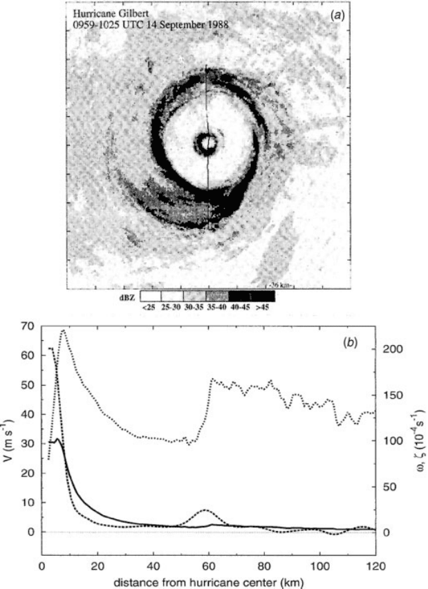
Figure 8 (a) Composite horizontal radar reflectivity of Hurricane Gilbert for 0959–1025
UTC September 14, 1988; the domain is 360 360 km, with tick marks every 36 km. The line
through the center is the WP-3D aircraft flight track. (b) Profiles of flight-level angular
velocity (solid), tangential wind (short dash), and smoothed relative vorticity (long dash)
along the southern leg of the flight track shown in (a). [From J. P. Kossin, W. H. Schubert, and
M. T. Montgomery, Atmos. Sci. 57, 3893–3917 (2000). Copyright owned by American
Meteorological Society.]
656
HURRICANES
The general mechanisms by which the eye and eyewall are formed are not fully
understood, although observations shed some light on the problem. The calm eye of
the tropical cyclone shares many qualitative characteristics with other vortical
systems such as tornadoes, waterspouts, dust devils, and whirlpools. Given that
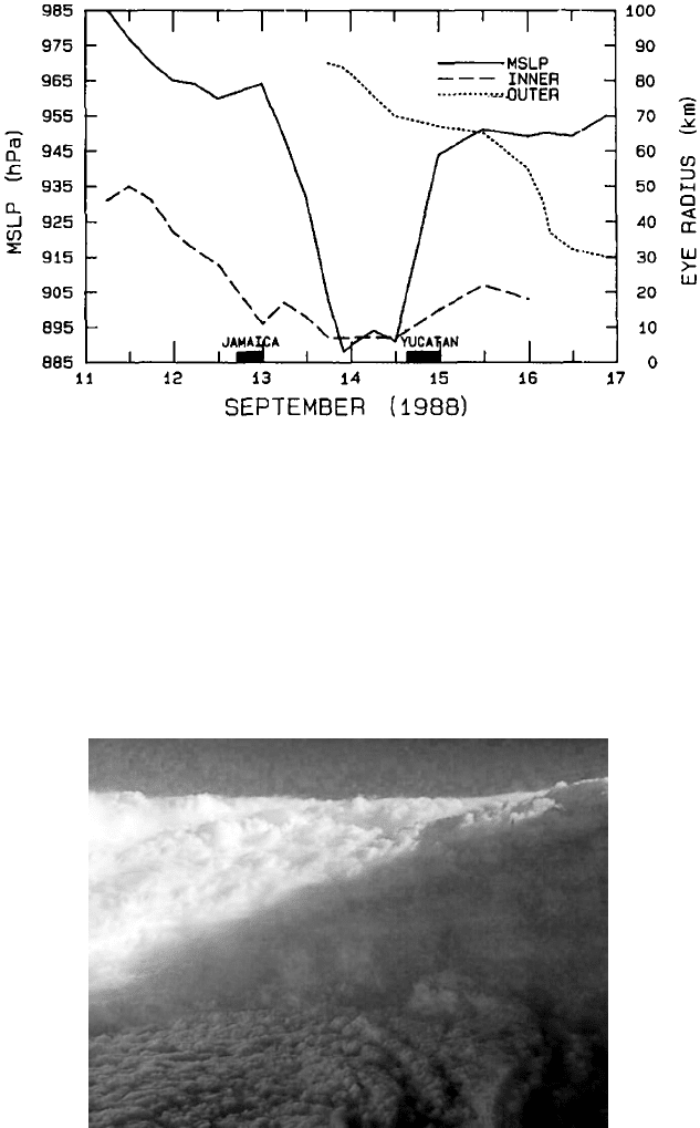
Figure 9 Hurricane Gilbert’s minimum sea level pressure and radii of the inner and outer
eyewalls as a function of time, September 1988. Solid blocks at bottom indicate times over
land. [From M. L. Black, and H. E. Willoughby, Mon. Wea. Rev. 120, 947–957 (1992).
Copyright owned by American Meteorological Society.]
Figure 10 Eyewall of Hurricane Georges 1945 UTC, September 19, 1998. (Photo courtesy
of M. Black, NOAA =OAR=AOML Hurricane Research Division.) See ftp site for color image.
4 BASIC STRUCTURE 657
many of these lack a change of phase of water (i.e., no clouds and diabatic heating
involved), it may be that the eye feature is a fundamental component to all rotating
fluids. It has been hypothesized that supergradient wind flow (i.e., swirling winds
generate stronger centrifugal force than the local pressure gradient can support)
present near the radius of maximum winds causes air to be centrifuged out of the
eye into the eyewall, thus accounting for the subsidence in the eye. However, others
found that the swirling winds within several tropical cyclones were within 1 to 4% of
gradient balance. It may be though that the amount of supergradient flow needed to
cause such centrifuging of air is only on the order of a couple percent and thus
difficult to measure.
Another feature of tropical cyclones that probably plays a role in for ming and
maintaining the eye is the eyewall convection. As shown in Figure 12, convection in
developing tropical cyclones is organized into long, narrow rain bands that are
oriented in the same direction as the horizontal wind. Because these bands seem
to spiral into the center of a tropical cyclone, they are sometimes called spiral bands.
The earliest radar observations of tropical cyclones detected these bands, which are
typically 5 to 50 km wide and 100 to 300 km long. Along these bands, low-level
convergence is a maximum, and therefore, upper-level divergence is most
pronounced. A direct circulation develops in which warm, moist air converges at
the surface, ascends through these bands, diverges aloft, and descends on both sides
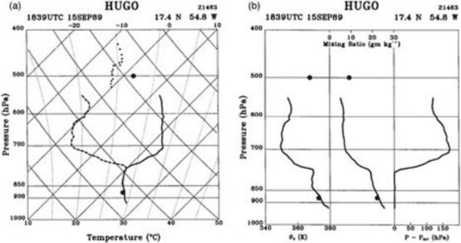
Figure 11 (a) Skew T log p diagram of the eye sounding in Hurricane Hugo at 1839 UTC on
September 15, 1989. Isotherms slope upward to the right; dry adiabats slope upward to the
left; moist adiabats are nearly vertical curving to the left. Solid and dashed curves denote
temperature and dew point, respectively. The smaller dots denote saturation points computed
for the dry air above the inversion, and the two larger dots temperature observed at the
innermost saturated point as the aircraft passed through the eyewall. (b) y
e
, water vapor
mixing ratio, and saturation pressure difference, P–P
SAT
, as functions of pressure at 2123
UTC. [From H. E. Willoughby, Mon. Wea. Rev. 126, 3189–3211 (1998). Copyright owned by
American Meteorological society.]
658
HURRICANES
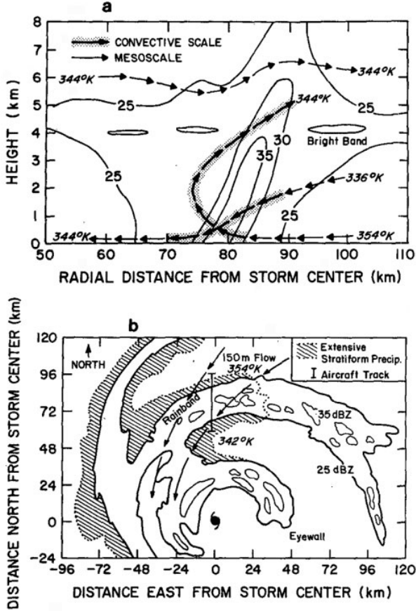
Figure 12 (a) Schematic of the rain band in radius–height coordinates. Reflectivity, y
e
,
mesoscale (arrows), and convective-scale motions are shown. (b) Plan view. Aircraft track,
reflectivities, cells, stratiform precipitation, 150-m flow, and y
e
values are shown. [From
G. M. Barnes, E. J. Zipser, D. P. Jorgensen, and F. D. Marks, J. Atmos. Sci. 40, 2125–2137
(1983). Copyright owned by American Meteorological Society.]
4 BASIC STRUCTURE 659
of the bands. Subsidence is distributed over a wide area outside of the rain band but
is concentrated in the small inside area. As the air subsides, adiabatic warming takes
place, and the air dries. Because subsidence is often concentrated on the inside of the
band, the adiabatic warming is stronger inward from the band causing a sharp
contrast in pressure falls across the band since warm air is lighter than cold air.
Because of the pressure falls on the inside, the tangential winds around the tropical
cyclone increase due to increased pressure gradient. Eventually, the band moves
toward the center and encircles it and the eye and eyewall form.
The circulation in the eye is comparatively weak and, at least in the mature stage,
thermally indirect (warm air descending), so it cannot play a direct role in the storm
energy production. On the other hand, the temperature in the eye of many hurricanes
exceeds that which can be attained by any conceivable moist adiabatic ascent from
the sea surface, even accounting for the additional entropy (positive potential
temperature, y, anoma ly) owing to the low surface pressure in the eye (the lower
the pressure, the higher the y at a given altitude and temperature). Thus, the observed
low central pressure of the storm is not consistent with that calculated hydrostatically
from the tem perature distribution created when a sample of air is lifted from a state
of saturation at sea surface temperature and pressure. The thermal wind balance
restricts the amount of warming that can take place. In essence, the rotation of
the eye at each level is imparted by the eyewall, and the pressure drop from the
outer to the inner edge of the eye is simply that required by gradient balance.
Because the eyewall azimuthal velocity decreases with height, the radial pressure
drop decreases with altitude, requiring, through the hydrostatic equation, a tempera-
ture maximum at the storm center. Thus, given the swirling velocity of the eyewall,
the steady-state eye structure is largely determin ed. The central pressure, which is
estimated by integrating the gradient balance equation inward from the radius
of maximum winds, depends on the assumed radial profile of azimuthal wind in
the eye.
In contrast, the eyewall is a region of rapid variation of thermodynamic variables.
As shown in Figure 13, the transition from the eyewall cloud to the nearly cloud-free
eye is often so abrupt that it has been described as a form of atmospheric front. Early
studies were the first to recognize that the flow under the eyewall cloud is inherently
frontogenetic. The eyewall is the upward branch of the secondary circulation and a
region of rapid ascent that, together with slantwise convection, leads to the congru-
ence of angular momentum and moist entropy (y
c
) surfaces. Hence, the three-dimen-
sional vorticity vectors lie on y
e
surfaces, so that the moist PV vanishes. As the air is
saturated, this in turn implies, through the invertibility principle applied to flow in
gradient and hydrostatic balance, that the entire primary circulation may be deduced
from the radial distribution of y
e
in the boundary layer and the distribution of
vorticity at the tropopause.
In the classic semigeostrophic theory of deformation-induced frontogenesis, the
background geostrophic deformation flow provides the advection of temperature
across surfaces of absolute momentum that drives the frontogenesis whereas, in
the hurricane eyewall, surface friction provides the radial advection of entropy
across angular momentum surfaces. Also note that the hurricane eyewall is not
660 HURRICANES
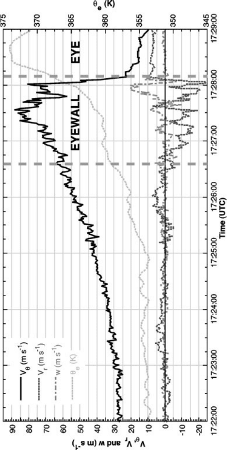
Figure 13 Time series plots of tangential wind (V
y
), radial wind (V
r
), vertical velocity (w), and y
e
in Hurricane Hugo for 1721–
1730 UTC, September 15, 1989. The aircraft flight track was at 450 m. Thick dashed vertical lines denote the width of the eyewall
reflectivity maximum at low levels. See ftp site for color image.
661
necessarily a front in surface temperature, but instead involves the y
e
distribution,
which is directly related to density in saturated air.
There is likely a two-stage process to eye formation. The amplification of the
primary circulation is strongly frontogenetic and results, in a comparatively shor t
time, in frontal collapse at the inner edge of the eyewall. The frontal collapse leads to
a dramatic transition in the storm dynamics. While the tropical cyclone inner core is
dominated by axisymmetric motions, hydrodynamic instabilities are potential
sources of asymmetric motions within the core. In intense tropical cyclones the
wind profile inside the eye is often ‘‘U-shaped’’ in the sense that the wind increases
outward more rapidly than linearly with radius (Fig. 13). The strong cyclonic shear
just inside the eyewall may result in a local maximum of absolute vorticity or angular
momentum, so that the profile may actually become barotropically unstable. This
instability leads to frontal collapse as a result of radial diffusion of momentum into
the eye and also may explain the ‘‘polygonal eyewalls’’ where the eyewall appear on
radar to be made up of a series of line segments rather than as a circle. It may also
explain intense mesoscale vortices observed in the eyewalls of hurricanes Hugo of
1989 and Andrew of 1992.
Once the radial turbulent diffusion of momentum driven by the instability of the
primary circulation becomes important, it results in a mechanically induced, ther-
mally indirect (warm air sinking) component of the seconda ry circulation in the eye
and eyewall. Such a circulation raises the vertically averaged temperature of the eye
beyond its value in the eyewall and allows for an amplification of the entropy
distribution. Feedbacks with the surface fluxes then allow the boundary layer entropy
to increase and result in a more rapid intensification of the swirling wind. Thus, the
frontal collapse of the eyewall is an essential process in the evolution of tropical
cyclones. Without it, amplification of the temperature distribution relies on external
influences, and intensification of the wind field is slow. Once it has taken place, the
mechanical spinup of the eye allows the temperature distribution to amplify without
external influences and, through positive feedback with surface fluxes, allows the
entropy field to amplify and the swirling velocity to increase somewhat more rapidly.
Outer Structure and Rain Bands
The axisymmetric core is characteristically surrounded by a less symmetric outer
vortex that diminishes into the synoptic ‘‘environment.’’ In the lower troposphere,
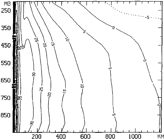
the cyclonic circulation may extend more than 1000 km from the center. As evident
in Figure 14 the boundary between cyclonic and anticyclonic circulation slopes
inward with increasing height, so that the circulation in the upper troposphere is
primarily anticyclonic, except near the core. In the outer vortex, there are no scale
separations between the primary and the secondary circulations, the asymmetric
motions, or the vortex translation as they are all of the same rough magnitude.
The asymmetric flows in this region control the vortex motion and sustain an
eddy convergence of angular momentum and moisture toward the center. Interac-
tions between the symmetric motions of the inner core with the more asymmetric
662 HURRICANES
motions in the outer portion of the storm are the key to improved forecasts of
tropical cyclone track and intensity.
Spiral bands of precipitation characterize radar and satellite images in this region
of the storm (Figs. 1 and 15). As seen in Figures 8, 12, and 15, radar reflectivity
patterns in tropical cyclones provide a good means for flow visualization although
they represent precipitation, not winds. Descending motion occupies precipitation-
free areas, such as the eye. The axis of the cyclone’s rotation lies near the center of
the eye. The eyewall surrounds the eye. In intense hurricanes, it may contain reflec-
tivities as high as 50 dB(Z),* equivalent to rainfall rates of 74 mm=h. Less extreme
reflectivities, 40 dB(Z) (13 mm=h), characterize most convective rainfall in the
eyewall and spiral bands. The vertical velocities (both up and downdrafts) in convec-
tion with highest reflectivity may reach 25 m=s, but typical vertical velocities are
<5m=s. Such intense convection occupi es <10% of the tropical cyclone’s area.
Outside convection, reflectivities are still weaker, 30 dB(Z), equivalent to a
2.4 mm=h rain rate. This ‘‘stratiform rain,’’ denoted by a distinct reflectivity maxi-
mum or ‘‘bright band’’ at the altitude of the 0
C isother m, falls out of the anvil cloud
Figure 14 Vertical cross section of the azimuthal mean tangential wind for Hurricane Gloria
on September 24, 1985. Anticyclonic contours are dashed. [From J. L. Franklin, S. J. Lord,
S. E. Feuer, and F. D. Marks, Mon. Wea. Rev. 121, 2433–2451 (1985). Copyright owned by
American Meteorological Society.]
*10 log
10
(Z), where Z is equivalent radar reflectivity factor (mm
6
=m
3
).
4 BASIC STRUCTURE 663
that grows from the convection. The spiral bands tend to lie along the friction layer
wind that spirals inward toward the eyewall (Fig. 12).
Many aspects of rain band formation, dynamics, and interaction with the
symmetric vortex are still unresolved. The trailing-spiral shape of bands and lanes
arises because the angular velocity of the vortex increases inward and deforms them
into equiangular spirals. In the vortex core, air remains in the circulation for many
orbits of the center; while outside the core, the air passes through the circulation in
less than the time required for a single orbit. As the tropical cyclone becomes more
intense, the inward ends of the bands approach the center less steeply approximating
arcs of circles. Some bands appear to move outward, while others maintain a fixed
location relative to the translating center.
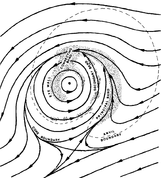
As shown in Figure 15, motion of the vortex through its surroundings may cause
one stationary band, called the ‘‘principal’’ band, to lay along a convergent stre am-
line asymptote that spirals into the core. A tropical cyclone advected by middle-level
steering with westerly shear moves eastward through surrounding air at low
Figure 15 Schematic representation of the stationary band complex, the entities that
compose it, and the flow in which it is embedded. [From H. E. Willoughby, F. D. Marks,
and R. J. Feinberg, J. Atmos. Sci. 41, 3189–3211 (1984). Copyright owned by American
Meteorological Society.]
664
HURRICANES
levels. Thus, the principal band may be a ‘‘bow wave’’ due to displacement of the
environmental air on the easter n side of the vortex. Its predominant azimuthal wave
number is one.
Moving bands, and other convective features, are frequently associated with
cycloidal motion of the tropical cyclone center, and intense asymmetric outbursts
of convection are observed to displace the tropical cyclone center by tens of kilo-
meters. The bands observed by radar are often considered manifestations of internal
gravity waves, but these waves can exist only in a band of Doppler-shifted frequen-
cies between the local inertia frequency (defined as the sum of the vertical compo-
nent of Earth’s inertial frequency f and the local angular velocity of the circulation,
V=r) and the Brunt–Vaisala frequency.* Only two classes of trailing-spiral, gravity
wave solutions lie within this frequency band: (i) waves with any tangential wave
number that move faster than the swirling wind, and (ii) waves with tangential wave
number 2 that move slower than the swirling wind.
Bands moving faster than the swirling wind with outward phase propagation are
observed by radar. They are more like squall lines than linear gravity waves. Waves
moving slower than the swirling wind propagate wave energy and anticyclonic
angular momentum inward, grow at the expense of the mean-flow kinetic energy,
and reach appreciable amplitude if they are excited at the periphery of the tropical
cyclone. Alter nate explanations for these inward-propagating bands involve filamen-
tation of vorticity from the tropical cyclone environment, asymmetries in the radially
shearing flow of the vortex, and high-order vortex Rossby waves. Detailed observa-
tions of the vortex-scale rain band structure and wind field are necessary to deter-
mine which mechanisms play a role in rain band development and maintenance.
While the evolution of the inner core is dominated by interactions between the
primary, secondary, and track-induced wave number one circulation, there is some
indication that the local convective circulations in the rain bands may impact on
intensity change. Although precipitation in some bands is largely stratiform, conden-
sation in most bands tends to be concentrated in convective cells rather than spread
over wide mesoscale areas. As shown in Figure 12, convective elements form, move
through the bands, and dissipate as they move downwind. Doppler radar observa-
tions indicate that the roots of the updrafts lay in convergence between the low-level
radial inflow and gust fronts that are produced by convective downdrafts. This
convergence may occur on either side of the band. A 20 K decrease in low-level
y
e
was observed in a rain band downdraft and suggested that the draft acts as a
barrier to inflow. This reduction in boundary layer energy may be advected near the
center, inhibit convection, and thereby alter storm intensity.
5 MOTION
Tropical cyclone motion is the result of a complex interaction between a number of
internal and external influences. Environmental steering is typically the most promi-
nent external influence on a tropical cyclone, accounting for as much as 70 to 90%
*Natural gravity wave frequency, the square root of the static stability defined as (g=y) @ y=@z.
5 MOTION 665
