Potter T.D., Colman B.R. (co-chief editors). The handbook of weather, climate, and water: dynamics, climate physical meteorology, weather systems, and measurements
Подождите немного. Документ загружается.


wind shear and the degree of buoyancy for rising parcels of air in the troposphere.
Given that thunderstorms will develop, SPC forecasters assess the values of these
two parameters from both ‘‘real-time’’ observational data and operational numerical
forecasts when deciding whether or not to forecast ‘‘isolated’’ supercells. If super-
cells are predicted, the forecaster then looks at other meteorological parameter values
to assess the risk of tornadoes, damaging winds, and=or large hail with the expected
supercells.
Making forecasts for severe thunderstorms requires detailed analysis of both real-
time observations and operational numerical model forecast data and trends. Since
the 1980s, computer workstations have been used to proces s and display ever-
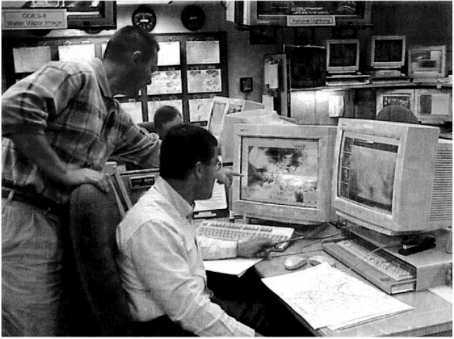
increasing quantities of meteorological data, and their use has helped forecasters
gain a better understanding of processes important for severe storm development
(Fig. 29). Outlook forecasters rely primarily on analysis of numerical model forecast
data for forecasts that extend out as far as 3 days ahead. Composite forecasts of
model data are typically constructed for key times within the forecast period
(Fig. 30). Adjusting for known model biases and limitations, the forecaster then
uses the patterns and positions of features on the composite forecast charts to
determine timing and area covered by potential severe storms. Model forecasts of
vertical profiles of wind, temperature, and moisture are then examined within the
forecast area to help estimate storm mode, intensity, evolution, and severe weather
type, if any.
Figure 29 Example of mesoscale analysis used by SPC to determine regions where the
threat of severe weather exists. See ftp site for color image.
616
SEVERE THUNDERSTORMS AND TORNADOES

For short-term forecasts (1 to 7 h ahead), the most recent day 1 outlook forecast
(current time to 24 h ahead) is used to focus attention on specific areas. Although
short-term operational numerical model trends are noted, the primary emphasis for
short-term forecasts is on analyzing real-time data and trends. Real-time data
includes both observations (e.g., radar reflectivity and wind data, satellite imagery,
lightning strike data, aircraft wind and temperature data, and upper air and surface
observations of temperature, moisture, air pressure, and wind direction and speed.)
and derived fields computed from this data (e.g., surface pressure changes over
time). For timely and accurate short-term products, continuous attention to details
and trends is very important because the atmosphere is constantly changing. For
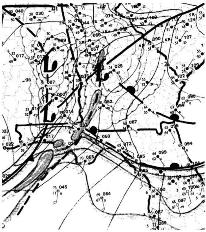
example, regional subjective analysis of surface observations (the densest opera-
tional data network available) is necessar y to assess the short-term severe weather
threat (Fig. 31). So, such analysis is typically done each hour. As significant small-
scale patterns, parameter values, and trends are diagnosed, mesoscale discussion
products consisting of one or two pa ragraphs are issued. These messages describe
the situ ation and how storms are expected to develop and=or evolve. A severe
thunderstorm or tornado watch is issued if the analysis reveals that there is a signifi-
cant threat of ‘‘organized’’ severe thunderstorm development that will last 4 or more
hours and affect more than a localized area (generally greater than 8000 square
miles).
Although the ingredients-based approach to severe thunderstorm forecasting
(parameter evaluation) has allowed more precision in severe weather forecasting
Figure 30 Example of a composite forecast for April 26, 1991. See ftp site for color image.
8 SEVERE STORM FORECASTING 617

during recent years, it appears that the climatological and pattern recognition aspects
of forecasting will continue to be utilized in the foreseeable future. There has been a
rapid increase in knowledge about storm processes in the past several years, but there
is still much to learn. Further, despite the increase in the amount of real-time data
available to forecasters, the operational data network is still not dense enough to
diagnose all parameter values and other features in enough detail to take advantage
of some newly understood storm-scale processes.
To complete the tornado warning process, local NWS Warning and Forecast
Offices, which have responsibility for much smaller areas, issue very short-range
warnings for events that are either occurring or imminent.
Figure 31 Regional subjective analysis of surface observations. See ftp site for color image.
618
SEVERE THUNDERSTORMS AND TORNADOES
FOR FURTHER READING
Bluestein, H. B. (1999). Tornado Alley. Monster Storms of the Great Plains, New York, NY:
Oxford University Press.
Grazulis, T. P. (2001). The Tornado: Nature’s Ultimate Wind Storm, Norman, OK: University of
Oklahoma Press.
Rinehart, R. E. (1997). Radar for Meteorologists, 3rd ed, Columbia, MO: Rinehart.
Vasquez, T. (2000). Weather Forecasting Handbook, Garland, TX: WeatherGraphics
Technologies.
FOR FURTHER READING 619

CHAPTER 30
TROPICAL PRECIPITATING
SYSTEMS
EDWARD J. ZIPSER
Precipitation is influenced by phenomena on all scales of motion. In the tropics
and subtropics, it is rare to find continuous precipitation on horizontal scales larger
than meso scale, whether related to a larger-scale disturbance or not. The reason is
straightforward: The stratification of temperature and moisture is such that the
equivalent potential tem perature (y
e
) decreases with height in most of the low
to midtroposphere. That is, the atmosphere is often both conditionally and convec-
tively unstable, such that large-scale lifting will inevitably result not in slow steady
ascent and light precipitation but in convective clouds and possibly heavy preci-
pitation. Adjacent regions normally have subsidence without precipitation, even
within regions of large-scale ascent or disturbances. This chapter surveys current
knowledge of tropical convective and mesoscale preci pitation and its organization.
We focus first on the physical nature of the precipitation systems themselves, and
only later examine the reasons for how those systems are forced, or organized.
The organizing systems are then arranged in order of scale, beginning with small-
scale orography and land–sea breezes, progressing to large and planet ary-scale
forcing.
1 DIFFERENCES BETWEEN TROPICAL AND
MIDLATITUDE CONVECTION
There are varying perceptions about tropical convection, not always rooted in reality. It
is important to examine the basis for statements about tropical phenomena. The old
Handbook of Weather, Climate, and Water: Dynamics, Climate, Physical Meteorology, Weather Systems,
and Measurements, Edited by Thomas D. Potter and Bradley R. Colman.
ISBN 0-471-21490-6 # 2003 John Wiley & Sons, Inc.
621
climatological school of thought spoke of the ‘‘daily thunderstorm to which one could
set one’s clock.’’ This belief has a grain of truth in some former British colonial
outposts of Malaysia or Africa, some of the time. Knowledge of the oceanic tropics
expanded during World War II, leading to descriptions not of boring un changing
climate but of synoptic-scale disturbances such as easterly and equatorial waves,
which sometimes intensified into tropical cyclones. Synoptic models of these waves
describe useful relationships between phases of the waves and weather. This repre-
sented an extension of synoptic meteorology thinking into the tropics, which
was helpful in some regions, was irrelevant or misleading in regions where
synoptic-scale systems do not control daily events, and mostly ignored mesoscale
phenomena.
Knowledge depends upon observations of appropriate scale. Motivated by a
series of devastating hurricanes in the 1950s, research aircraft penetrations of hurri-
canes provided such data, leading to major advances in description, understanding,
and prediction of tropical cyclones (Marks, F. D. Jr., Chapter 32). In the meantime,
quantitative radar and mesoscale data in the severe storm regions of the United
States led to analogous knowledge of storms bearing hail and tor nadoes (Brooks,
H. et al., Chapter 30). It would be nearly 20 years before such tools would be used
for ‘‘ordinary’’ tropical weather. The motivating factor was not weather forecasting
but the increasing realization that global models of weather and climate required
sound treatment of ‘‘subgrid-scale’’ phenomena in the tropics. The conceptual
framework for the Global Atmospheric Research Program (GARP) and its Atlantic
Tropical Experiment (GATE) was created in the 1960s, under the leadership of Jule
Charney, Verner Suomi, and Joseph Smagor insky. Following a series of smaller field
experiments in the late 1960s, the GATE was carried out in the eastern Atlantic in
1974, ending forever any lingering thoughts that large-scale and small-scale
phenomena can be treated independently.
The landmark ‘‘hot tower’’ study of Riehl and Malkus (1958) had already condi-
tioned meteorologists to the belief that tropical cumulonimbus clouds were not just
decorations, responsible for local showers and the heavy rains that constitute many
tropical climates. The se convective towers were shown to be a critical link in the
general circulation, transporting heat, moisture, and moist static energy from the low
to high troposphere for subsequent export to higher latitudes. They also have an
essential role in hu rricane formation and maintenance. Thus, it becomes easier to
accept the truth that tropi cal convection must be parameterized if global models were
to be successful. It perhaps was natural to believe that these hot towers of the deep
tropics were also some of the biggest and most powerful storms on the planet, but
observations demonstrated otherwise.
Research aircraft equipped to derive vertical velocity made thousands of penetra-
tions of convective clouds, both isolated and embedded in mesoscale convective
systems (MCSs, more about these below). Beginning in GATE, but over a 20-year
period in other field programs , including the Bay of Bengal, offshore Borneo,
offshore northern Australia, offshore Taiwan, the warm pool of the equatorial west
Pacific, and tropical cyclones in several oceans, the results were remarkably similar.
622 TROPICAL PRECIPITATING SYSTEMS

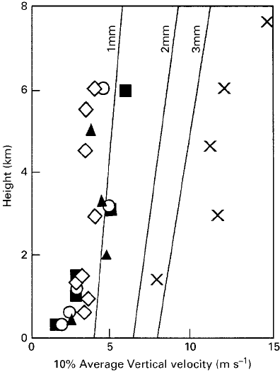
Most tropical convective clouds were weak. Typical maximum updrafts were a factor
of 2 to 3 lower than those in ordinary cumulonimbus clouds over land (Fig. 1).
Updraft and downdraft velocity, diam eter, and mass flux are approximately lognor-
mally distributed.
But it would be wrong to assume that weak convection characteri zes the entire
tropics. The cited observations are entirely from the oceanic tropics. Few data exist
from continental tropical regions, not coincidentally because local knowledge
of intense convection over land would quickly discourage pilots from attempting
penetrations. The true hot towers, therefore, are mainly confined to certain regions,
e.g., India–Bangladesh, Argentina, southern United States, and Africa. Recent satel-
lite data show the distribution of intense storms more quantitatively (see Section 7).
The common oceanic cumulonimbi still perform their major role of energy trans-
port and precipitation; the vertical speed is simply smaller than previously
imagined.
Figure 1 Average vertical velocity in the strongest 10% of updraft cores over tropical oceans
from measurements in three different regions (triangles, circles, diamonds) and over land
(crosses, Thunderstorm Project). The lines show terminal fall speeds of raindrops as a function
of raindrops diameter and height. (after Zipser and Lutz, 1994).
1 DIFFERENCES BETWEEN TROPICAL AND 623
2 MESOSCALE CON VECTIVE SYSTEMS (MCSs)
There is no precise definition of an MCS. The essence of an organized mesoscale
convective system is that it is a recognizable entity of a distinctly larger temporal
and spatial scale than its constituent convective clouds. That is, the MCS lives for
several hours and covers a horizontal scale of the order of 100 km in at least one
dimension, while the ordinary cumulonimbus cloud may live for one hour and cover
the order of 10 km. Many MCSs are unmistakably well organized, such as the squall
line or mesoscale convective complex (MCC; Section 4). Some are not.
Mesoscale convective systems are widely distributed throughout the world. The
fundamental processes by which groups of cumulonimbus clouds become organized
into MCSs, and which govern the structure and evolution of MCSs, are independent
of latitude. (The sole exception is the Coriolis effect, which influences the asym-
metry and inertial stability of particularly large, long-lived MCSs.) Given the impor-
tant role of MCSs in the United States, there is some irony in the fact that so much of
what we know about them comes from field programs over tropical oceans, trans-
ferred to midlatitudes later. The first field program explicitly targeting MCSs over
the United States was carried out in Oklahoma and Kansas in 1985.
The literature on MCSs is dominated by studies of squall lines. The reason is the
great simplification inherent in a quasi-two-dimensional system. Concentrating on
squall lines results in little loss of generality, provided one remembers that more
complex or disorganized systems are often more common.
3 SQUALL LINE AND MCS STRUCTURE
The best-known type of squall line has a leading convective region and a trailing
stratiform precipitation region. It is fairly common in almost all regions, the easiest
to study, and therefore the best-known MCS. The convective region is usually 10 to
30 km in width, followed by a region of stratiform precipitation that often exceeds
100 km in width. When such a system passes over a given location, the weather
experienced includes a few heavy convective showers (often >25 mm=h) followed
by several hours of steady precipitation (often 3 to 5 mm=h). Rainfall from the
convective region depends up on details of individual cells, their intensity, and
their relation to the observer; from the stratiform region it depends mainly on
duration of the moderate rain.
Convective updrafts within MCSs are basically similar to those in more isolated
storms but are concentrated in space and time. Updraft speeds rarely exceed 3 to
10 m=s over oceans and 10 to 25 m=s over land. Diameters rarely exceed 5 km except
in supercells. The mesoscale updrafts occupy the upper half of the troposphere in the
stratiform precipitation region, with updraft speeds in the 10 to 100 cm=s range over
an area that may extend for 100 km.
The convective downdrafts in the convective region form a cold pool at low levels
that quickly spread s out to cover a large area. This cold pool can be thought of as one
of the exhaust products of the system, analogous to the more easily visible exhaust
624 TROPICAL PRECIPITATING SYSTEMS
product of the convective updrafts: the anvil system, which spreads out near and
below the level of neutral buoyancy (equilibrium level). The cold pool has the
important function of helping to continuously generate new convective cells, usually
along its advancing edge (e.g. Houze 1993, Chapters 8 and 9). The interior of the
cold pool is usually sufficiently stabilized that new deep convective cell growth is
impossible. Even over warm tropical oceans, while heat and moisture transfer can
restore the boundary layer properties and make new convection potentially possible,
another element of the MCS usually prevents it: the mesoscale downdraft.
The mesoscale downdraft is universally found below the melting level in the
stratiform precipitation region, beneath the mesoscale updraft. The evaporation of
precipitation fails to keep the meso scale downdraft saturated, and relative humidity is
often below 80% and can be as low as 50% in the 1 to 2 km levels. Therefore, in spite
of thick anvil-type clouds above, steady rain, and occasionally lightning, there are
usually no clouds at all below the melting layer. All precipitation in this region was
initially frozen before falling through the melting layer. The mesoscale downdraft
cannot penetrate through the shallow cold pool to the surface, so can be detected by
aircraft or soundings (Fig. 2). The result is a characteristic onion-shaped sounding
(Fig. 3). Under most circumstances, the combination of a shallow, capped cold pool
and a warm, dry unsaturated downdraft dictates that the air in the stratiform region of
an MCS cannot generate new deep convection for at least 12 to 24 h.
Mesoscale downdrafts have been attributed to three causal mechanisms, and all
three mechanisms act together in most MCSs. The latent heat of fusion cools the
air when ice melts. Although the magnitude is only 13% of the latent heat of
evaporation, the cooling takes place in a concentrated layer only a few hundred
meters thick, having the effect of lowering the 0
C isotherm on the mesoscale,
generating or accelerating descent. The evaporation of falling precipitation is a
powerful cooling process, assuming subsaturation of the ambient air. Once descent
begins for any reason, however, evaporation can be effective. A final reason is that
the cold pool near the surface always tends to diverge, so air above the cold pool
must descend.
In both tropics and midlatitudes, some 40% of rainfall from MCSs falls in the
stratiform precipitation region. The question arises: Which process is most important,
the condensation= sublimation growth of ice particles in the strong ascent in the
mesoscale updraft, or horizontal transfer of convective debris (ice) from the convec-
tive region? The answer is that both are required for substantial precipitation rates and
that both are present in MCSs. While this result comes from simulation experiments,
the remarkable fact is that no documented case exists of an MCS cloud structure
without prior existence of deep convection. Some earlier descriptions of rainfall
systems have mistakenly ascribed the existence of widespread light precipitation to
midlevel convergence in subtropical cyclones or monsoon depressions. This is very
doubtful; the misconception arises when synoptic-scale reasoning is applied to
situations where mesoscale processes are responsible for the specific cloud and
precipitation features.
3 SQUALL LINE AND MCS STRUCTURE 625
