Potter T.D., Colman B.R. (co-chief editors). The handbook of weather, climate, and water: dynamics, climate physical meteorology, weather systems, and measurements
Подождите немного. Документ загружается.

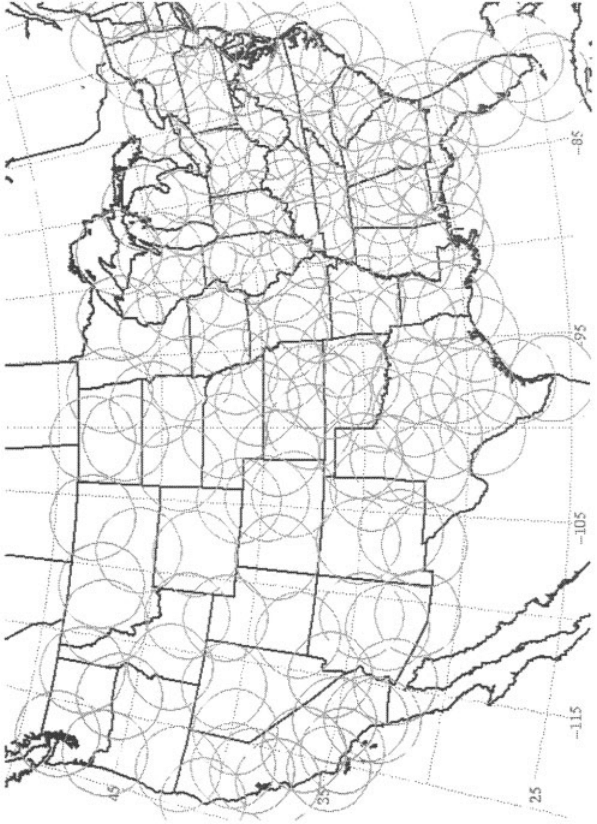
Figure 20 The 230-km range of each WSR-88D radar site.
606
Storm Structure Revealed by Radar Observations
Precipitation echoes from mature thunderstorms usually are easily recognizable even
by incoherent radars. On a PPI display they are characterized by high reflectivities
(reflectivity is proportional to the sixth power of all the hydrometeor diameters
within the pulse volume with units of mm
6
=m
3
and is expressed in logarithmic
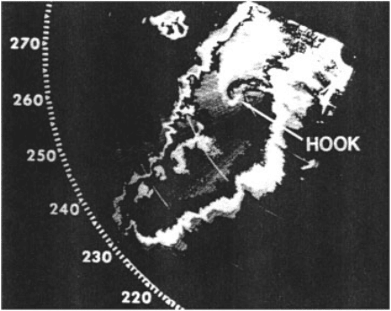
units) and sharp gradients of intensity (Fig. 21). The presence of ‘‘hook’’ echoes,
or echoes with notches, on their southern sides has been correlated with tornadic
potential. The value of Doppler radar in identifying tornadoes was first shown in the
early 1970s when velocities were measured from inside the Union City, Oklahoma,
thunderstorm. The pattern of large wind shear (termed a tornado vortex signature)
between adjacent beams on either side of the tornado location seen by ground
observers persisted for over 40 min throughout a deep depth of the thunderstorm.
A significant finding for possible tornado warning was the presence of this shear
pattern aloft for about 20 min before the tornado was on the ground. Often, however,
most Doppler radars do not actually ‘‘see’’ a tornado because of its small size
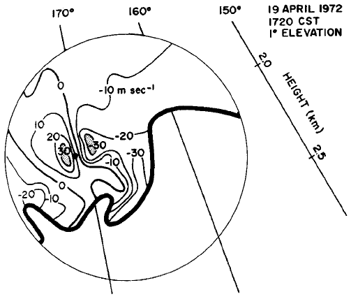
relative to the beam size. It is the much larger parent circulation (termed a
mesocyclone), often high up in the storm, which is first detected by the Doppler
radar (Fig. 22).
While tornado detection by Doppler radar is an important component of the NWS
warning responsibility, single Doppler radars also identify many other severe
weather hazards. For example, strong downdrafts (often termed downbursts) that
can affect the safety of airplanes can be identified by the pattern of Doppler velocity
Figure 21 Plan Position Indicator (PPI) display of contoured echo power of the ‘‘Tabler’’
storm on June 6, 1974, in central Oklahoma (from Brandes, 1977). The region labeled
‘‘HOOK’’ is an indication of a likely region for a tornado. Radar location is in the upper right.
Range marks (arcs) are spaced 20 km. Echoes are contoured in a gray–white–black pattern
starting at 10 dBZ in 10 dBZ steps.
7 RADAR CHARACTERISTICS OF SEVERE STORMS 607
divergence near the ground. Storms that produce large hail are recognized by their
elevated reflectivity structure aloft.
Although important for recognizing the presence of severe weather through
patterns of velocity, single Doppler radars provide only limited information about
the internal circulations of storms, particularly updraft and downdraft strengths that
are critical for precipitation formation processes. A single Doppler radar can only
provide information about the component of the flow directed either toward or away
from the radar. To derive actual wind fields at least two Doppler radars are required.
Thus, to understand why storms move the way they do and produce tornadoes, hail,
and sometimes damaging straight-line winds, researchers have utilized multiple
Doppler radars, and even Doppler radars mounted on airplanes, to provide simul-
taneous observations that can be combined to produce a three-dimensional descrip-
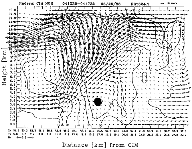
tion of the flow within severe storms. Figure 23 is an example of combining the radar
data from two radars to produce an analysis of the updraft through a strong hailstorm
observed on May 26, 1985. In this case the two radars were the Cimarron Doppler
radar operated by the National Severe Storms Laboratory and a Doppler radar
mounted on the WP-3D aircraft from the National Oceanic and Atmospheric
Administration. By flying the aircraft close to the storm, the beams from the
aircraft’s radar, which was scanning in a vertical orientation normal to the aircraft’s
flight track, can be combined with the PPI scans from the Cimarron radar.
Progress toward understanding the complex dyna mic and microphysical forces
acting to control the behavior of severe storms has certainly been aided by multiple
Figure 22 Single Doppler radar signature of a strong mesocyclone indicative of rotation.
Dot indicates location of tornado. Negative velocities are approaching the radar. Straight lines
labeled in degrees indicate azimuth radials from the radar (from Burgess and Lemon, 1990).
608
SEVERE THUNDERSTORMS AND TORNADOES
Doppler case studies. Doppler radar data, however, suffers from a number of limita-
tions, the most severe of which is its restriction to areas where there are hydro-
meteors that scatter the electromagnetic radiation. Thus clear air regions are usually
devoid of observations unless the storm is very close to the radar and the clear air
contains some other particle scatterer such as insects. Even in those circumstances
the amoun t of coverage is generally slight. One of the most powerful approaches has
been to combine Doppler radar with numerical simulations of convective storms.
The simulations use observed environmental conditions to initialize the grid domain
and the Doppler observations to validate the computed solutions. Numerical simula-
tions, even using state-of-the-art approaches, have significant limitations. Even so,
useful insights have been derived from these simulations in the case of the strongest
and longest-lived convective storm, the supercell thunderstorm, as evidenced by the
closeness of simulations and Doppler observations where they overlap, such as the
high reflectivity region of the storm core where tornadogenesis occurs.
The hypothesis that emerges of tornadogenesis from the analysis of Doppler
winds and numerical simulations is that the vertical vorticity (or ‘‘spin’’) develops
initially from the tilting of environmental vorticity set up by the low-level wind shear
into the vertical by the principal storm updraft. Once initiated, the vorticity is
Figure 23 Vertical cross section through the core of a hailstorm simultaneously observed by
the P-3 aircraft and the Cimarron Doppler radar on May 26, 1985. Solid lines are reflectivity
(dBZ). The 10 m=s wind vector is shown in the upper right.
7 RADAR CHARACTERISTICS OF SEVERE STORMS 609
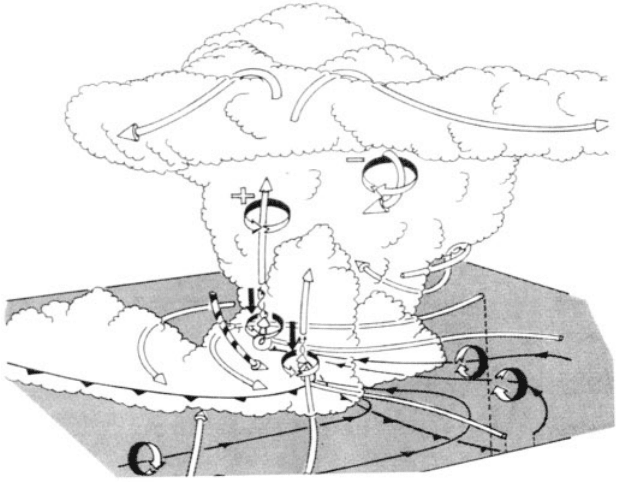
increased by concentration of spin by convergence of air similar to the way in which
a figure skater increase his or her spin by contracting their arms (called conservation
of angular momentum). This process is illustrated schematically in Figure 24.
Numerical simulations reveal the pressure gradient forces implied in the Doppler
winds. Both observations and numerical models have shown that strong low-level
rotation promotes a downdraft that spreads cold air at low levels around the storm
and helps create convergence along the resultant ‘‘gust front.’’ These features have
also been seen visually by storm intercept teams.
Future Advances
Doppler radars have enabled consi derable leaps in our understandi ng and improve-
ments in warning lead-time of severe storms. The establishment of a national
network of Doppler radars (Fig. 20) has provided nearly complete nationwide cover-
age. Some hazards, however, are not optimally detected by the WSR-88D network
(e.g., aviation hazards such as downbursts and sudden near-surface wind shifts
caused by gust frontal passage) and require specialized radars for each major airport
called the Terminal Doppler Weather Radar (TDWR) used by the Federal Aviation
Figure 24 Three-dimensional schematic representation of the processes leading to tornado
formation based on Doppler radar and numerical simulations. Cylindrical arrows depict flow
in and around the storm. Thin lines show the low-level vortex lines, with vector direction by
arrows along the lines and sense of direction also by circular-ribbon arrows. (Adapted by
Klemp, 1987.)
610
SEVERE THUNDERSTORMS AND TORNADOES
Administration (FAA). These specialized radars can also be used to augment the
WSR-88D coverage and improve the NWS warning lead time.
Tied to the national network is the ability to rapidly process and interpret the
single Doppler radar data for the detect ion of a variety of hazards through pattern
recognition. This ‘‘marriage’’ of the computer and radar greatly accelerates the
detection of patterns that can be very subtle and often are embedded in large
areas of high reflectivity. WSR-88D radar data from the May 3, 1999, Oklahoma
City tornado outbreak is shown integrated wi th the computerized warning decision
process in Figure 25. The Warning Decision Support System (WDSS) can indepen-
dently track many storm cells simultaneously and provide forecast guidance as to
rain severity, hail size, tornadic potential, and probably accurate tornado location and
tracking without requiring a dedicated radar scientist.
Other technological advances in development may help identify and warn of
severe storm hazards. For example, improved hail detection and rainfall estimation
may be possible with polarization of the radar beam. In this approach, two pulses are
alternatively transmitted with orthogonal polarizations (e.g., horizontal and vertical).
The polarization of each received pulse is measured and various products (such as
the ratio of the horizontal-to-vertical polarizations) can be computed. According to
electromagnetic scattering theory, if a particle were not circular, it would scatter
preferentially in its long axis, i.e., a pancake-shaped raindrop would scatter more
horizontally polarized radiation than vertical polarization. This information can be
used to improve the accuracy of rainfall estimates, discriminate hail from heavy rain,
and reduce uncertainties about the drop-size distrib ution that is being sampled. The
application of polarimetric obser vation to weather forecasting is still an active area of
research. Even so, the utility of polarimetric data in improving weather forecasting is
already recognized and the NWS is already planning to upgrade the U.S. WSR-88D
radar network to have this capability.
One of the most severe limitations to multiple Doppler radar analysis is the rather
large uncertainty in vertical air motion estimates. If fundamental problems in
convective dynamics are to be addressed, these uncertainties need to be reduced
so that a more complete picture of the mass, momentum, pressure, vorticity, thermo-
dynamic, electrical, and water substance interactions can be examined. One of the
ways to reduce the uncertainties is to observe the phenomena at higher spatial and
temporal density since it is known that convective elements possess large kinetic
energy on spatial scales of 1 to 2 km and exhibit significant evolution over 1 to 3 min.
Therefore ‘‘rapi d-scan’’ radars that can sample a storm volume within 1 min at data
densities of 200 to 300 m are needed. Such data would permit adjoint analysis
methods with cloud resolving numerical models to be implemented. This type of
radar is currently used in military applications and possibly could be adapted to
examine severe weather.
8 SEVERE STORM FORECASTING
In the United States, the National Weather Service’s Storm Prediction Center (SPC)
in Norman, OK, is responsible for forecasting thunderstorm occurrence as well as
8 SEVERE STORM FORECASTING 611
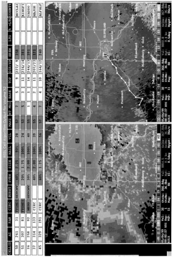
Figure 25 (see color insert) Screen output from the National Severe Storms Laboratory Warnings Decision
Support System of the May 3, 1999, Oklahoma City tornado. The table at the top shows the system is tracking 5
different storms with a variety of algorithm-determined characteristics such as direction and speed of motion,
presence of hail and its maximum size, whether a circulation or mesocyclone is present, and its echo top. Left panel
is radar reflectivity with cities and county boundaries as background. Boxes with numbers correspond to locations
of tracked storms. Right panel is radial velocity. White line is storm #50 track with future positions shown as the
purple line. Yellow circle shows the presence of the tornado vortex signature. (Courtesy of Greg Stumpf of the
National Severe Storms Laboratory.) See ftp site for color image.
612
most hazardous weather associated with thunderstorms. This includes tornadoes,
damaging straight-line winds, large hail, and heavy rainfall that can result in flash
floods. The SPC’s primary focus is on the risk of tornadoes, damaging straight-line
winds (58 mph or greater), and large hail (
3
4
inch or greater in diameter). In this
section we will explain how the SPC makes forecasts for thunderstorms and these
three hazards.
Severe thunderstorm forecasting began in earnest in the mid-twentieth century.
The U.S. Air Force began making rudimentary internal forecasts for severe weather
in the late 1940s. By the early 1950s, the National Weather Service formed a
national unit of specialists to forecast severe thunderstorms and tornadoes for the
48 contiguous states. Called the National Severe Storms Forecast Center, this unit
was based in Kansas City, Missouri, for more than 40 years before relocating to
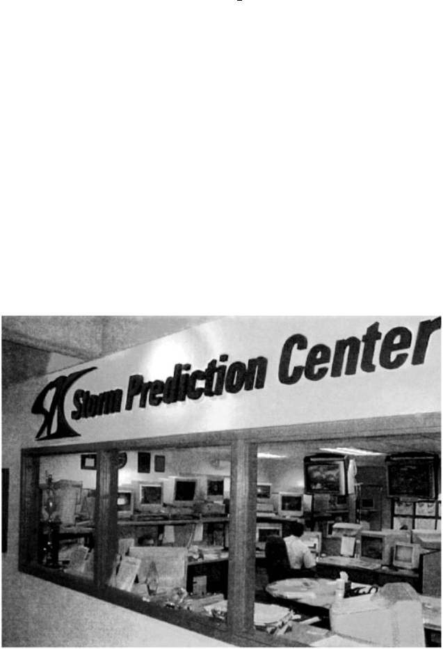
Norman, Oklahoma, and being renamed the Storm Prediction Center in 1997
(Fig. 26). Currently, 20 specialized meteorologists work in teams of four to monitor
weather conditions around the clock, 7 days a week, all year long. An ‘‘outlook’’
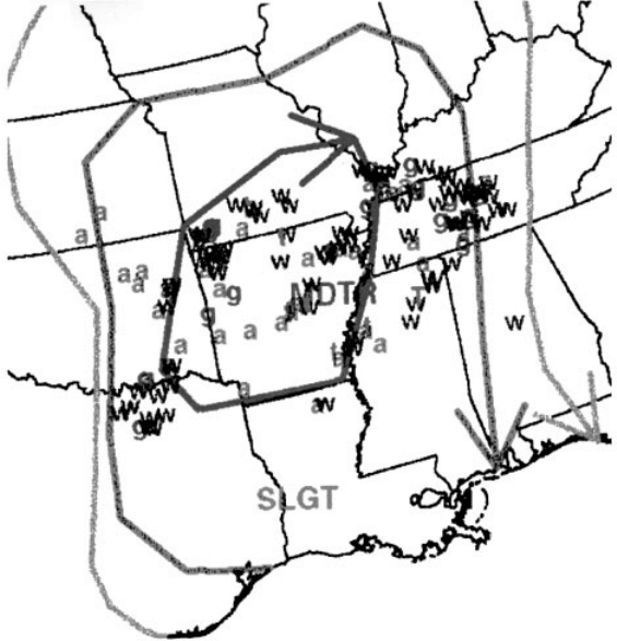
forecaster makes forecasts for severe weather out to 3 days ahead (Fig. 27). The
other three specialists issue short-term forecasts (1 to 7 h ahead) that include tornado
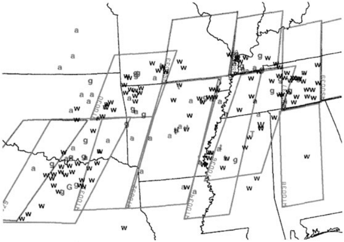
and severe thunderstorm watches as well as other products. Typically, watches are
parallelogram in shape covering an area averaging about 25,000 square miles (about
the size of the state of Iowa; Fig. 28). A severe thunderstorm watch is issued when
there is a significant and concentrated threat of damaging straight-line winds and=or
Figure 26 Storm Prediction Center operations area. Forecaster Jeff Peters studies data on
one of several high-speed workstations. See ftp site for color image.
8 SEVERE STORM FORECASTING 613
large hail. Tornado watches are issued when there is a threat of tornadoes. There may
also be a threat for damaging winds and large hail within a tornado watch. Signifi-
cant and=or concentrated severe weather typically results from ‘‘organized’’ severe
thunderstorms, those that are of the superc ell, bow echo, or strong multicell modes.
Generally, forecasting severe thunde rstorms involves three concepts: climatology,
pattern recognition, and parameter evaluation. Climatology is used by SPC
forecasters to know what time of day, season, and area they should expect a
higher likelihood of severe weather development. For example, in the Great Plains
region of the United States, spring tornadoes are most likely to occur in the late
afternoon and evening hours. Given a typical severe weather situation for the region,
forecasters anticipate an enhanced risk at that time. In the winter, however, the
highest risk of tornadoes in Florida and the coastal regions of the southeastern
states is during late night and morning hours, nearly the diurnal opposi te of the
Plains states in spring. Therefore, given the typical severe weather situation in the
southeastern United States in the winter, an SPC forecaster’s anticipation of tornado
development based on climatology is enhanced for the period from midnight until
noon.
Figure 27 Example of SPC outlook and watch area. See ftp site for color image.
614
SEVERE THUNDERSTORMS AND TORNADOES
Pattern recognition is used by SPC forecasters as a first approximation concerning
severe thunderstorm development. Features such as the upper-level jet stream
(20,000 ft or higher above ground level), the low-level jet stream (from 2000 to
5000 ft above ground level), fronts, thermal and moisture axes, etc. are examined.
The intensity, orientation, juxtaposition, and movement of these features aid the
forecaster in estimating the probability of occurrence, area affected, timing, and
severity of potential severe weather episodes. As an example, most large tornado
outbreaks are associated with a pattern that includes dual upper jet streams that
diverge over the outbreak area and a strong southerly low-level jet stream that
transports warm and moist air into the area. The strength and movement of these
jet streams play a major role in the severity, area affected, and timing of the outbreak.
Finally, parameter evaluation (also called ingredients-based forecasting) has
become increasingly important in forecasting severe thunderstorms in recent
years. Atmospheric scientists have learned much about thunderstorm development
and evolution over the five decades since the first severe weather forecasts were
made. This knowledge is derived from observations, theoretical studies, and numer-
ical modeling experiments. Application of this knowledge has resulted in forecast
techniques that relate values of meteorological parameters to the type of storms that
develops, their evolution, and the types of severe weather (large hail, damaging
winds, and =or tornadoes) associated with them. As an example, ‘‘isolated’’ super-
cells can generally be associated with varying combinations of the amount of vertical
Figure 28 Composite forecast map used by SPC to overlay various surface and upper-level
features to help poinpoint potential severe weather threats. See ftp site for color image.
8 SEVERE STORM FORECASTING 615
