Middleton G.V. (Ed.) Encyclopedia of Sediments and Sedimentary Rocks
Подождите немного. Документ загружается.

TIDAI FLATS
735
the tidal biisin il determines the volume of the tidal prism and
hence the tidal discharge. Being an easily determined
parameter, the tidal range has been used to classify tidal
coasts. The most widely applied scheme to date is that of
Davies (1964) in which micmtidal shores (0--2m) are
distinguished from mesotidal (2 4m) and macrotidal (>4m)
ones.
An ahernative scheme comprising five subdivisions, and
thus offering greater dilTerentiation. is that of Hayes (1979) in
which microtidal shores (0-1 m) are distinguished from low-
mcsotidal (I 2m). high-inesotidid (2-3.5m), low-macrotidal
(3.5 5.0111), and high-macrotidal (>5m) ones. This latter
scheme takes distinct, process-related geomorphie teatures into
consideration.
Modern tidal-tlat depositionai systems are commonly found
in estuaries and along low-iying coaslal-plain shores between
the equator and the polar seas at tidal ranges above about
0.5m. They can attain shore-normal widths of several
kilometers, alongshore extensions of many His to lOOs of
kilometers, and vertical accretion lieights of several lOs to lOOs
of meters (Davis. 1994; Ehlcrs. 1998). They occur along barred
a[id non-barred sea shores, and within estuaries. Along non-
tidal or microtida! shores wiih less than 0.5 m tidal range,
"pseudo-iidal"" fiats may be found which have much in
common with true tidal fiats, but lack the regular tidal
rhythm. Here the inundation interval is eontrolled by wind
set-up,
the resulting depositionai environment being known as
•"wind fiats"". Back-barrier tidal fiats are limited to tidal ranges
between about 0.5 m and 3.5 m, the transition to nonbarrcd
tidal fiats being controlled by the interaction between the tidal
range and wa\e action (e.g,, Hayes, 1979). At tidal ranges
above 3.5 m tidal fiats are always nonbarred. irrespective of the
wave climate. Extreme macrotidal ranges occur where the
length ofa shallow, funnel-shaped bay approximates a quarter
wavelength of the tidal wave. In such cases., the natural
oscillation of the water body resonates with the tidal period
and the tidal wave is hence superimposed on a standing wave.
This results in strong amplification of tidal water levels at ihe
head of such bays as. for example, in the Bay of Fundy,
Canada (Dalrymple and Zaitlin. I9S9). in the Severn Hstuary.
Great Britain (Allen. 1990). or in the Bay of Mont St Michel.
France (Larsonneur, 1994). French (1997) distinguishes no less
than seven intertidal coastal types based mainly on morphol-
ogy and facies successions.
Sedimentology, stratigraphy, and facies associations
Tidal fiats occur in both siliciclastie and carbonate deposi-
tionai systems (e,g,. Ginsburg. 1975) and have been docu-
mented in the rock record since Archaean times over 3.300 Ma
ago (eg.. Hobday and Eriksson, 1977). Important benchmark
papers in tidal fiat research published before 1970 ean be
found in Klein (1976). Following the settling lag/scour lag
mechiiuism along the tidal energy gradient (Van Straaten and
Kuenen, 1957), grain sizes progressively tine toward the
shore. The result is a sedimentary facies succession that has
recentiy been classified on the basis of mud content (<;/.
[•lemming, 2000). It commences with sand fiats (<5 percent
mud) at the high-energy end near the low-tide level, and
proceeds through slightly muddy sand fiats (5 25 percent
mud),
muddy sand flats (25 50 percent mud), sandy mud flats
(50 75 percent mud), slightly sandy mud fiats (75 95 percent
mud),
to mud fiats (>95 percent mud) at the low-energy end
(high-tide Ie\cl), Sand fiats can usually be fiu'ther subdivided
into a variety of size classes, the total range depending on
overall sediment supply and energy fiu\. Numerous aspects of
mudfiat piopcrtics and processes, including a typological
classification of mud flats and a discussion of mass physieal
properties, can be found in Dyer (2000),
Along the energy gradient, tidal Hats display numerous
physical and biological sedimentary structures, both on the
surface and in cross-section (e.g.., Klein, 1977: Reineck and
Singh, 1980), only a few (such as tidal rhythmites) being
unequivocally diagnostic (e,g,, Visser. 1980). Exposed sandy
tidal Hats are dominated by physical structures generated by
waves and currents (complex wave and current ripple
structures, dune cross-bedding, upper plane bed lamination,
fiuid escape structures, etc). Strong bioturbation is rare in
sand Hats, As energy levels decrease, burrowing organisms
such as polychaete worms and molhiscs in temperate climates
or callianassid shrimps in tropical and subtropical climates
begin to bioturbate the sediment, the degree of bioturbation
generally increasing toward the finer-grained sediment facies.
Mud enters the sedimentary system in the Ibrm of either
sortable silt partieles or fiocs and aggregates (including faecal
pellets) composed of finer-grained components (generally
<iO|.im). Deposition of the low-density mud fiocs and other
aggregates follows the principle ol' hydraulic equivalence as
refiectcd in the progressive increase in mud content along
the energy gradient (Flemming, 2000). As a result, muddy
intertidal sediments arc aetually well sorted. At the same time,
primary sedimentary struetures such as mud-draped ripple
cross-beds evolve into flascr, wavy, and lenticular bedding
units before merging into horizontally laminated muds at the
landward margin. Contorted and convoluted mud beds with
mud-cracked surf"accs appear at the transition to the lower
supratidal environment as desiccation at neap tide promotes
compaction, while storm-generated silt layers may be inter-
spersed along more exposed parts of the system. Above the
mean high-tide level, i-oot-structures of salt-marsh plants begin
to intensely bioturbate the sediment.
Tidal fiat depositionai systems evolve in response to the
longer-term sediment budget which, in turn, is a f~unetion of
the rate of sedimeni supply from external sources and the rate
of sea-level rise (or fall). Thus, if the sediment supply exceeds
the deficit created by sea-level rise, the system will prograde
seawards while aggrading. If both are balanced, then the
system will simply aggrade in place. On the other hand, if the
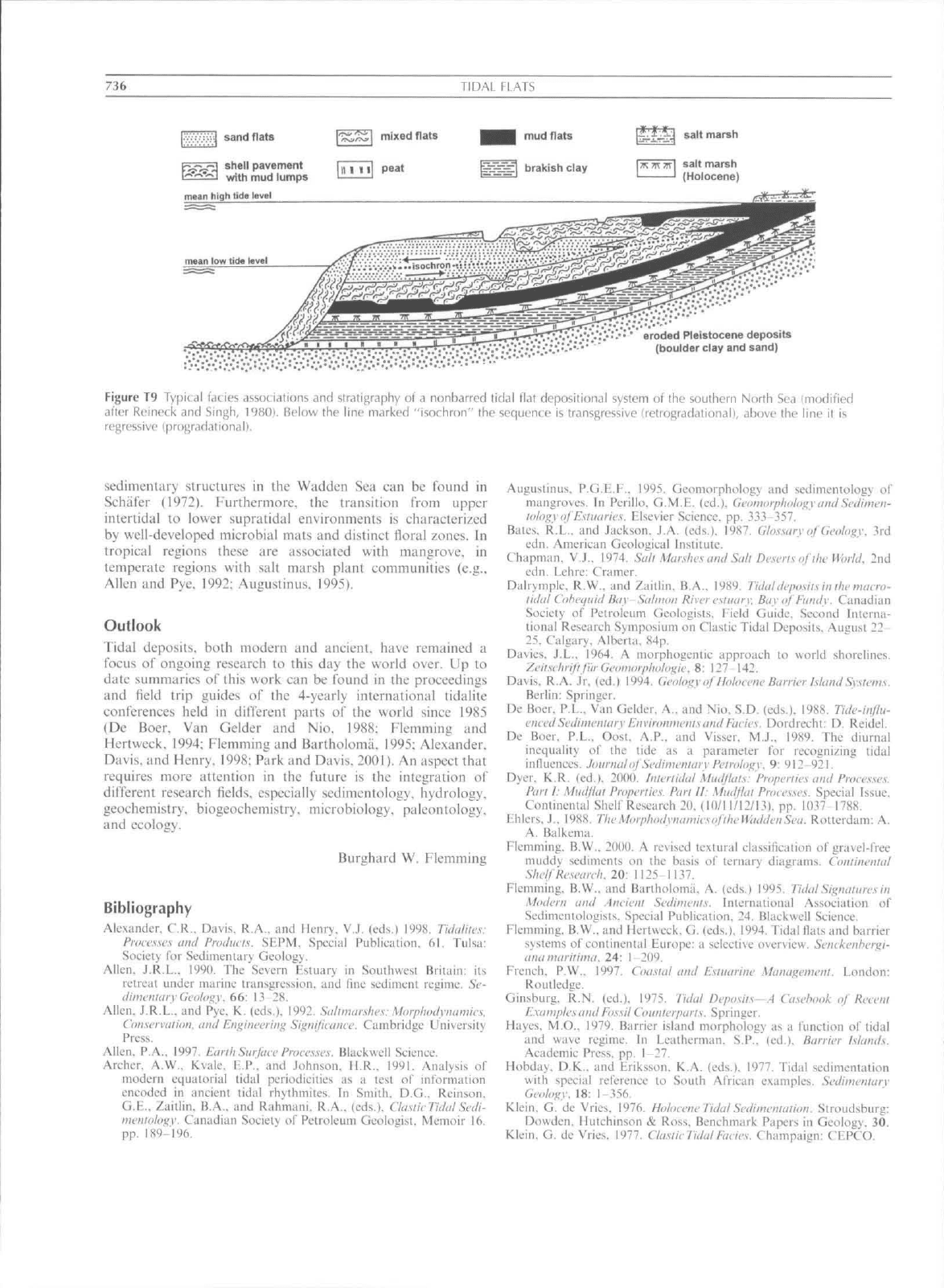
deficit exceeds the supply, then reworking along the seaward
margin results in transgressivc landward displacement of the
indi\idual facies belts (Figure T9).
Biological aspects
Besides the influence of physical parameters such as currents,
wave action and grain size, the nature of intertidal deposits is
strongly affected by the presence or absence of particular
animal and plant associations. In recent years, the importance
of microbial communities has received increasing attention
(e.g,, Krumbein ciaL. 1994), The nature of biological influence
on tidal-flat depositionai systems depends on species composi-
tion and community structure which both change with
geographic locality and climatic setting (e.g.. Chapman,
1974;
Reise. 2001). As a result, tidal fiats in different parts of
the world can often be distinguished on the basis of
characteristic biological surface structures and bioUirbation
patterns, A systematic sludy of biologically generated
736
TIDAL FLATS
sand flats
Fj^>73 shell pavement
[^•.-.vq
^^^y
^yj
lumps
mean high lida level
^^H mudflats
t^3^=fl brakish clay
•..,•.•.*•;;'•.•:/.*"••''
eroded Pleistocene deposits
•'.'•:*•-'•'''
(boulder clay and sand)
Figure T9 Typical tacies associations and stratigraphy
of
a nonbarrcd tidal flat depositional system
of
ihe southern North Sea (modified
alter Reineck and Singh, 1980). Below the line marked "isochron" the sequence is transgressive (retrogradationall, above fhe line
if is
regressive (progradational).
sedimentary structures iti the Wadden Sea can be found in
Sehiifer (1972). Furthermore, fhe transition tVom upper
intertidal lo lower supratidal environments is characterized
by well-developed microbial mats and distinct fioral zones. In
tropical regions these are associated with mangrove, in
temperate regions with salt marsh plant communities (e.g.,
Alien and Pye. 1992; Augustinus. 1995).
Outlook
Tidal deposits, both modern and ancient, have remained a
focus of ongoing research fo fhis day the world over. Up to
date summaries of this work can be found in fhe proceedings
and fieid trip guides of the 4-yearly international fidalife
conferences held in difterent parts of the world since 1985
(De Boer, Van Gelder and Nio. 1988: Flemming and
Hertweck. 1994; Flemming and Bartholoma, 1995; Alexander.
Davis, and Henry. 1998; Park and Davis. 2001). An aspect ihaf
requires more affenfion in the fufure is the ititcgrafion of
different research fields, especially sedimentology. hydrology,
geochemistry, biogeochemisfry. tnicrobiology, paleonfology.
and ecology.
Burghard W. Flemniing
Bibliography
Alexander. C.R., Davis. R.A., and Henry. V.J. (eds.) 1998. Tichiliics:
Processes
uud
Pwduci.s. SHPM, Special Publication.
61.
Tulsa:
Society
for
Sedimentary Geology.
Allen.
J.R.L.. 1990.
TIIL-
Severn Estuary
in
Southwest Brilnin:
its
rcircat under marine transgression, and fine sediment regime. Sc-
diiiicnitiiy
Geology.
66: 13 28.
Allen,
J.R.L.. and Pye.
K.
(eds.). 1992.
Sci/iiiuir.slu-y
Morphodyimmics.
Conserwilion. mid Engineering Significaiivc. Cambridge University
Press.
Allen,
P.A.,
1997. Emih
Surfuce
Processes..
Blackwell Science.
Archer. A.W.. Kvale,
E.P.. and
Johnson,
H.R..
1991. Analysis
of
modern eqiiaiorial tidal periodicities
as a
tesi
o!"
informntion
encoded
in
ancient tidal rhytlimites.
In
Smith.
D.G.,
Reinson,
G.E., Zaitlin, B.A., and Rah'mani, R.A.. (eds.). ChisliiTiihil
Sedi-
nit'iitolo^v. Canadian Society ol" Petroleum Geologist. Memoir
16.
pp.
1S9-'|96.
Augustinus. P.G.E.F., 1995. Geomorpliology
and
sedimentology
of
mangroves.
In
Perillo. G.M.F. (ed.), GeonuiipluiltigyundSedimeii-
loh^yof
E.simines.
Elsevier Science, pp. 33.V357.
Bates,
R.L.,
and ,lackson.
J.A-
(eds.), 1987.
Gh.ssary
of
Geology.
3rd
edn.
American Geological Institute.
Chapman,
V,J., 1974. Siill Mur.shesandS<dl Dcscriscflfie
H'biid.
2nd
edn.
Lehre: Cramer.
Diilrymplc, R.W.. and Zaitlin,
B.A..
1989. Tidiildeposits in llie niucio-
lidid Cohi'tjiiid Bity-Sitlmoit Riveresiitiiiy. Bay
cf
Finuly. Canadian
Society
of
Petroleum Geologists. Field Guide, Seeond Iniema-
tional Research Symposium on Clastic Tidal Deposits, August 22-
25,
Calgary. Alberta, 84p.
Davics.
J.L.,
1964.
A
morphogentic approach
lo
world shorelines.
Zei/.^clii
ifi
fill Geonioipliologii\
8: 127 t42.
Davis.
R.A. Jr.
(ed.) 1994.
Geofogy
of
Holocene
Boirier Island
Sysienn.
Berlin:
Springer.
De Boer. P.L., Van Gelder, A., and Nio. S.D. (eds.). 1988. Tide-infiu-
cncedSedinienKirv EnvironiiienlscindFiicies. Dordrecht:
D.
Reidel.
De Boer,
P.L.,
Oosf.
A.P.. and
Visser,
M.J.. 1989. The
diurnal
inequality
of the
tide
as a
parameler
for
recognizing tidal
influences. Journalof Scdinienlary
PclyoloiiW
9:
912
921.
Dyer.
K.R,
(ed.), 2(K)(). hilerlidtif Atiidf!ai.\:
Properiies
ciiid
Processes.
Pan
I:
Mudfkil
Properlies.
Pan
ll:
Mtidfliil
Proefs.\es.
Special Issue,
Continental Shelf Research 20,
(10/11/12/131,
pp. 1037
178S.
Ehlers,
J,, 1988. TheMorphodynamiesoflheWuddenSea. Rotterdam:
A.
A, Balkema.
Flemming,
B.W., 2000.
A
revised lextural classification
of
gra\el-frec
muddy sediments
on the
basis
of
ternary diagrams. Coniinennif
Shelf Research.
20:
1125-1137.
i'lemming. B.W,. and Bartholoma,
A.
(eds.) 1995. TidalSif^nciliircsin
Modern
und
Ancienl Sediments. International Association
of
SedimeiUologists, Special Publication, 24. Blackwell Science.
Flemming.
B.W.. and ifertweck. G. (eds.), 1994. Tidal Hats and barrier
systems
of
continental tiurope:
a
selective ovcr\icw. Senckciibergi-
luw niariiinia. 24:
1-209.
French,
P.W., 1997.
Couslal and Eslitarinc Shuitigenietn. London:
Rout
ledge.
Ginsburg,
R.N.
(ed.).
1975.
Tidal Deposits—A
Ca.sefwof<
of
Heceni
E.xainpfes
and
Eo.ssU
Coiinlerparis. Springer.
Hayes.
M.O.. 1979, Barrier island morphology as
a
function
of
tidal
and wave regime.
In
Leathermaii.
S.P.,
(ed.). Barrier Islands.
Academic Press, pp.
1-27.
Hobday,
D.K..,
and Eriksson.
K.A.
(eds.). 1977. Tidal sedimentation
with special reference
lo
South African examples. Scdinit'iiiarv
Geology. 18:
1-356.
Klein.
G. de
Vries, 1976. HofocenvTidaf Svdinieniaiion. Stroudsburg:
Dowden,
Hutchinson
&
Ross, Benchmark Papers
in
Geology,
30.
Klein.
G.
de Vries, 1977. ChsiicTidalFuews. Champaign: CFPCO.
TIOAl
INLETS
AND
DELTAS
737
Krumbein. W,F., Patcrson, D.M., and Stai, L,J, (eds,), I9')4,
Hi<>-
shihiiizaliun afSetliitu-nls. Oldenburg: BlS-Vcrhig,
Larsonneiir, C, I9y4, The bay of Morii-Sairu-Michcl; a seiiimcination
model in a temperate macrotidal environment, Scnckenhci-giaiin
niiniliDia, 24:
.1-63,
Oust, A.P., de Haas, H., Ijnscn, F,, van den Boojicrt, J,M,, aiu!
de Boer, P.L,, 1993. The 18.6 year nodal cycle and Its impact on
tidal sedimenlation. ScLtiinfimirvGcclugy. 87: 1 II,
Park. Y,A,, and Davis. R,A. Jr (eds), 20(')l. Proccfdin^sof Tiihilhcs
200(1.
Seoul: Korean Society of Oceanography,
Roineck. H,-E,. and Singh, I,B,, 1980, DepositkmulSedimcnhiiyEnvir-
tiiii)u-iu.\.
2nd cdn. Springer-Verlag.
Rcise, K.,
2(1(11,
Etuloy^icul
Ciniipari'<iinsajSvdimeuutryShores. Berlin:
Springer-Verlag,
Schaler, W,. 1972, Eitilogy uitd Pukwoiroloiiy of Maiiiw Emiruninvul.s.
Edinburgh: Oliver & Boyd,
Smith, D.G,, Reinsnn. G,F-,. /aitlin. B.A-, and Rahmani, R,A, (eds.).
1991.
Clii.sit'rV'ichil
SL'cliiin''iiolos;y.
Canadian Society of Petroleum
Geologists, Memoir 16,
Van Straaten, L,M.J,l.,. and Kuenen. P,H.. 1957. Accumulation of
(inc grained sediments in the Dulch Wadden Sea, Ccoloi^iceiiMijn-
hoiiu. 19: 3:9 354,
Visi^er. R., I9S0. Neap-spring cyelcs rellected in Ihilocene subtidal
large-scale bedtbrm dep()sit,s: a preliminary note, Gculo^v. 8: 543
546,
Williams. G,E,. 1991. Upper Proierozoic tida! rhythmites. South
Australia: sedimentary lealures, deposition, and implications for
the earlh's paleorotalion. In Smith, D,G,, Reinson, G,E,, Zaitlin,
B.A., and Ralmunii. R.A, (eds,), CUisiic Tiiltd Sedinwnuilof-y.
Canadian Soeiely ot" Petroleujn Geologists, Memoir 16, pp.
I6I-I7S,
Cross-references
Barrier
ISIJIKIS
Bedding and Internal Structures
Biiigenic Sedimentary Structures
t\iastal Sedimenlary Facies
Flaser
Grain Settling
Grain Size and Sliape
Ripple. Ripple Mark, and Ripple Strueture
Sail Marshes
Sediment Transport by Tides
Smi'ace Forms
Tides and Tidal Rhylhmites
TIDAL INLETS AND DELTAS
A liilaliiilci is an opening in the shoreline through which water
penetrates the land thereby providing a connection between
the ocean and bays, lagoons, marsh, and tidal creek systems.
Tidal currents maintain the main channel of a tidal inlet. The
second hair of this definition distinguishes tidal inlets from
large, open enibaymcnts or passageways along rocky coasts.
Tidal currents al inlets are responsible for the continual
removal of sediment dumped into the main channel by wave
action. Thus, according to this definition tidal inlets occur
along sandy or sand and gravel barrier coastlines, although
one side may abut a bedrock headland. Some tidal inlets
coincide with the mouths of rivers (estuaries) but in these cases
inlet dimensions and sediment transport trends are still
governed, to a larize extent, by the volume of water exchanged
at the inlet mouth (tidal prism) and the reversing tidal currents,
respectively.
Tidal inlets are found along barrier coastlines throughout
the world. They provide a pathway for ships and small boats
to travel between the open ocean to sheltered waters. Diversity
in the morphology, hydraulic signature, and sediment trans-
port patterns of tidal inlets attests lo the complexity of their
processes. The variability in oeeanographie. meteorological,
and geologie parameters, such as tidal range, wave energy.
sediment supply, storm magnitude and frequency, fresh water
influx, and geologic controls, and the interactions of these
factors, are responsible for this wide range in tidal inlet
settings. At most inlets over the long-term, the volutne of water
entering the inlet during the Hooding tide equals the volume of
water leaving the inlet during the ebbing cycle. This volume is
referred to as the lidalprism. The tidal prism is a function of
the open water area and tidal range in the backbarrier as well
frictional factors, which govern the ease of flow through the
inlet.
The formation of a tidal inlet requires the presenee of an
embayment and the development of barriers. In coastal plain
settings, the embayment or backbarrier was often created
through the eonstruction of the barriers themselves, like much
of the Kast Coast of [he United States or the Friesian Island
coast along the North Sea (FitzGerald and Penland, 1987;
Fit/Gerald, 1996). Breaching of a barrier and spit accretion
across a bay are the eommon meehanisms of inlet formation.
In other instances, flooding of former river valleys has also
produced embayments associated uith tidal inlet development.
Tidal deltas
A tidal inlet is specifically the area between two barriers or
between the barrier and the adjacent bedrock or glacial
headland. The deepest part of an inlet, the ink'l fhwat. is
located normally where spit accretion of one or both of the
bordering barriers constricts the inlet channel to a minimum
width and minimum cross sectional area. Here lidal currents
normally reach their maximum velocity. Commonly, the
strength of the currents at the throat causes sand to be
removed from the channel floor leaving behind a lag deposit
consisting of gravel or shells or in some locations exposed
bedrock or indurated sediments. Closely associated with tidal
inlets are sand shoals and tidal channels located on the
landward and seaward sides of the inlets. Flood lidal currents
deposit sand landward of the inlet forming a flood-riikildi'lla
and ebb-tidal currents deposit sand on the seaward side
forming an cbh-iidaUlclla.
Flood-tidal deltas
Their presence or absence, size, and development are related to
a region's tidal range, wave energy, sediment supply and
baekbarrier setting. Tidal inlets that are backed by a system of
tidal channels and salt marsh (mixed-energy coast) usually
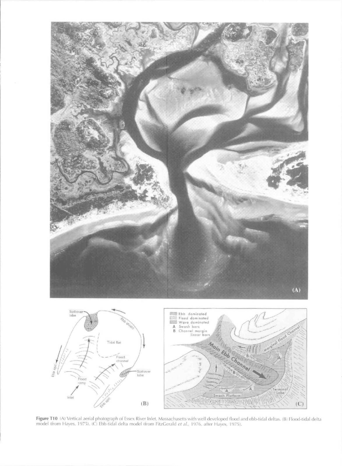
contain a single horseshoe-shaped flood-tidal delta (e,g,. Essex
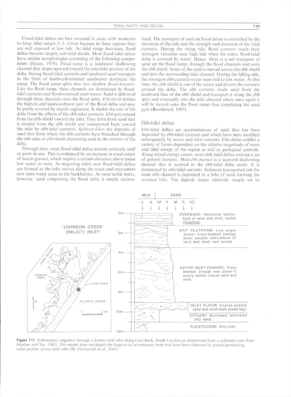
River Inlet. Massachusetts; Figure TIO), Contrastingly, inlets
that are backed by large shallow bays may contain multiple
flood-tidal deltas. Along some microtidal coast, such as Rhode
Island, flood deltas form at the end of narrow inlet channels
cut through the barrier. Changes in the locus of deposition at
these deltas produce a multj-lobate morphology resembling a
lobate river delta (Boothroyd ciai. 1985), Flood delta size
commonly increases as the amount of open water area in the
backbarrier increases.
Spill ever
lobe
(B)
mW Ebb daminaled
;'-.'.
Flood dominated
^
Wave dofninored
A Swoih bats /'
B Chonnel morqm
neot
oba'.'
-hNl"
x'
''
-
Figure
TIO (A)
Vertical aerial phulograph
ol
Essex River Inlet, Massachusetts with well developed flood
and
ebb-lid<il deltas.
(B)
Flood-tidal delta
model Itrom Hayes, 1975).
(C)
Ebb-tidal delta model (from FitzGerald
et .il..
I'-Ub. dfter Hayes, 1975).
J\D,M.
INLETS AND DELTAS
739
Klood-tidal deltas are best revealed in areas with moderate
to large tidal ranges (1.5-3.0 m) becatise in Ihese regions they
are well exposed at low tide. As tidal range decreases, flood
deltas become largely sub-tidal shoals. Most flood-tidal deltas
have similar morphologies consisting of the following compo-
nents (Hayes. ]979). Flood
vamp
is a landward shallowing
channel that slopes upward toward the intertidal portion ofthe
delta.
Strong (lood-tidal currents and landward sand transport
in the form of landward-oriented sandwaves dominate the
ramp.
The flood ramp splits into two shallow ^<;(K/(7/(;/;y)c/,v.
Like the flood ramp, these channels are dominated by flood-
tidal currents and flood-oriented sand waves. Sand is delivered
through these ehaniicK onto the flood delta, Ebhshwld defines
the highest and landwardmost part of the flood delta and may
be partly covered by marsh vegetation. It shields the rest of the
delta from ihe elTects of ihe ebb-tidal currents.
Ehhsptl.s
extend
from ihe ebb shield toward the inlet. They form from sand that
is eroded from the ebb shield and transported back toward
the inlet by ebb-tidal currents.
Spillover lobes
are deposits of
sand that form where the ebb currents have breached through
the ebb spits or ebb shield depositing sand in ihe interior of ihe
delta.
Through time, some flood-tidal deltas accrete vertically and/
or grow in size. This is evidenced by an increase in areal extent
of marsh grasses, which require a certain elevation above mean
low water lo exist. At migrating inlets new flood-tidal deltas
are formed as the inlet moves along the coast and eneounters
new open water areas in the backbarrier. At most stable inlets,
however, sand comprising the flood delta is simply recircu-
latcd-
The transport of
sand
on flood deltas is eontrolled by the
elevation of the tide and the strength and direction of the tidal
currents. During the rising tide. Hood currents reach their
strongest velocities near high tide when the entire flood-tidal
delta is covered by uater. Hence, there is a net transport of
sand up the Hood ramp, through the Hood channels and onto
the ebb shield. Some of the sand Is moved across ihe ebb shield
and into the surrounding tidal channel. During the falling tide,
the strongest ebb currents occur near mid to low water. At this
time,
the ebb shield is out of the water and diverts the currents
around the delta. The ebb currents erode sand from the
landward face of the ebb shield and transport it along the ebb
spits and eventually into the inlet channel where once again it
will be moved onto the flood ramp thus completing the sand
gyre (Boothroyd. 1985),
Ebb-tidal deltas
Ebb-tidal deltas are accumulations of sand that has been
deposited by ebb-tidal currents and whieh have been modified
subsequently by waves and tidal eurrents. Ebb deltas exhibil a
variety of forms dependent on the relative magnitude of wave
and tidal energy of the region as well as geological controls.
Along mixed energy coasts, most ebb-tidal deltas contain a set
of general features.
Mcdnehh ehunnel
is a seaward shallowing
channel that is scoured in the ebb-tidal delta sands. It is
dominated by ebb-tidal currents. Sediment transported out the
main ebb channel is deposited in a lobe o\' sand forming the
terminal lube. The deposit slopes relatively steeply on its
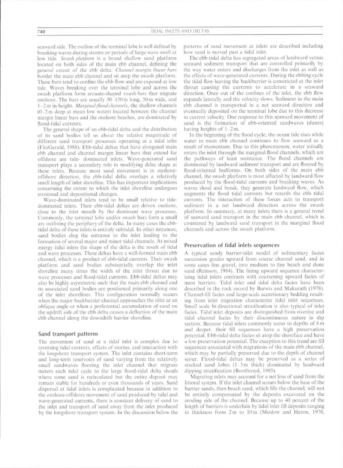
MUD
SAND
"JOHNSON CREEK"
(RELICT) INLET
C VC
OVERWASH: Horizontal lamina-
tions of sand and shell; rooted
fSpartlna).
SPIT PLATFORM: Low angle
planar cross-bedded (wedge
sets);
parallel laminations ol
»and and shell; well sorted.
ACriVE INLET CHANNEL: Cross
bedded (trough and planar?)
poorly sorted, coarse sand and
shell.
INLET FLOOR: Coarie-pebbly
sand and shell hash {basal lag).
ESTUARY: Burrowed, laminated
slity sand.
PLEISTOCENE: Silty-clay,
Figure T11 Sedimentary sequence through a former tidal inlel along Core
B.3nk,
North Carolina as determined from a sediment core (from
Moslovv and Tye,
19851.
This model does not depitt the large-scale accretion,iry beds th<it have been ohserved in j^round-penetrating
radar profiles across tidal inlet tills (Fit/Gerald ef.)/,, 2001),
740
TIDAL INLCTS AND DbLTAS
seaward side. The outline of the terminal lobe is well defined by
breaking waves during storms or periods of large wave swell al
low tide.
Swct.sli
pUttfonu is a broad shallow sand platform
located on both sides o^ Ihc main ebb channel, dclining the
general extent of the ebb deita. Cftaitttvl tmtijiiii liitcar hars
border the main ebb channel and sit atop the swash platform.
These bars tend to confme the ebb flow and arc exposed at low
tide.
Waves breaking over the terminal lobe and across ihe
swash platform form arcuate-shaped swash
har.s
thai migrate
onshore. The bars are usually 50-l50m long, 50m wide, and
l-2m in height. Mariiitwl-floodchatitu'ls. the shaliow channels
(0-2 m deep at mean low water) located between the ehannel
margin linear bars and the onshore beaches, are dominated by
ilood-iidal currents.
The general shape of an ebb-tidal delta and the distribution
of its sand bodies (ell us about the relalive magnitude of
different sand transport processes operating at a tidal inlet
(FitzGerald. 19S8). Ebb-tidal dehas that have elongated main
ebb channel and channel margin linear bars that extend far
offshore are tide- dominated inlets. Wave-generated sand
transport plays a secondary role in modifying delta shape at
these inlets. Because most sand movement is in onshore-
offshore direction, the ebb-tidal delta overlaps a relatively
small length of inlet shoreline. This has imporlant Implications
concerning the extent to which the inlet shoreline undergoes
erosional and depositional changes.
Wave-dominated inlets tend to be small relative to tide-
dominaied inlets. Their ebb-tidal deltas are driven onshore,
close to the inlet moulh by the dominant wave processes.
Commonly, the terminal lobe and/or swash bars form a small
arc outlining the periphery ofthe delta. In many cases the ebb-
tidal delta of these inlets is entirely subtidal. In other instances,
sand bodies clog the entrance to the inlet leading lo the
formation of several major and minor tidal channels. At mixed
energy tidal inleis the shape of the delta is the result of tidal
and wave processes. These deltas have a well-formed main ebb
channel, uhich is a product of ebb-tidai currents. Their swash
platform and sand bodies substantially overlap the inlet
shoreline many times the width of the inlet throat due lo
wave processes and flood-tidal currents. Ebb-tidal deltas may
also be highly asymmetric such that the main ebb channel and
its associated sand bodies are positioned primarily along one
of the inlet shorelines. This configuration normally occurs
when the major backbarrier channel approaches the inlet at an
oblique angle or when a preferential accumulation of sand on
the updrift side of the ebb delta causes a deflection ofthe main
ebb channel alony the downdrift barrier shoreline.
Sand transport patterns
The movement of sand al a tidal inlet is complex due to
reversing tidal currents, effects of storms, and interaction with
the longshore transport system. The inlet contains short-term
and long-term reservoirs of sand varying from the relatively
small sandwaves flooring the inlet ehannel that migrate
meters each tidal cycle to the large flood-tidal delta shoals
where some sand is reeirculated but the entire deposit may
remain stable for hundreds or even thousands of years. Sand
dispersal at tidal inlets is complicated because in addition to
the onshore-offshore movement of sand produced by tidal and
wave-generated currents, there is constant delivery of sand to
the inlet and transport of sand away from the inlet produced
by the longshore transport system. In the discussion below the
patterns of sand movement at inlets are described including
how sand is moved past a tidal inlet.
The ebb-tidal delta has segregated areas of landward versus
seaward sediment transport thai are controlled primarily by
the way water enters and discharges from the inlet as well as
the effects i^f wave-generated currents. During the ebbing cycle
the tidal flow lea\ing the backbarrier is constricted at the inlet
throat causing the currents to accelerate in a seaward
direction. Once out of the confines of the inlet, the ebb flow
expands laterally and the velocity slows. Sediment in the main
ebb channel is transported in a net seaward direction and
eventually deposited on the terminal lobe due to this decrease
in current velocity. One response to this seaward movement of
sand is the formation of ebb-oriented sandwaves (dunes)
having heights of !-2m.
In the beginning ofthe flood cycle, the ocean tide rises while
water in main ebb channel continues to flow seaward as a
result of momentum. Due to this phenomenon, water initially
enters the inlet through the marginal flood channels, which are
the pathways of least resistance. The flood channels are
dominated by landward sediment transport and are floored by
flood-oriented bedforms. On both sides of the main ebb
channel, the suash platform is most affeeted by landward flow
produced by the flood-tidal currents and breaking waves. As
waves shoal and break, they generate iandward flow, which
augments the flood tidal currents but retards the ebb tidal
currents. The interaction of these forces acls to transport
sediment in a net landward direction across the swash
platform. In summary, at many inlets there is a general trend
of seaward sand transport in the main ebb channel, which is
countered by landward sand transport in the marginal flood
channels and across the swash platform.
Preservation of tidal inlets sequences
A typical sandy barrier-inlet model of sedimentary faeies
succession grades upward from coarse channel sand, and in
some cases fine gravel, into meditim to tine beaeh and dune
sand (Reinson, 1984). The lining upward sequence character-
izing tidal inlets eontrasls with coarsening upward facies of
mosl barriers. Tidal inlet and tidal delta facies have been
described in the rock record by Barwis and Makurath (1978).
Channel-fill facies and large-scale accretionary bedding result-
ing from inlet migration characterize tidal inlet sequences.
Small scale bi-directional stratification is also typical of inlet
facies.
Tidal inlet deposits are distinguished from riverine and
tidal ehannel facies by their discontinuous nature in dip
section. Because tidal inlets commonly scour to depths of
8
m
and deeper, their fill sequenees have a high preservation
potential. Ebb-tidal delta facies sit atop the shoreface and have
a low preservation potential. The exception to this irend arc flli
sequences associated with migrations ofthe main ebb channel,
wiiich may be partially preserved due to the depth of channel
scour. Flood-tidal deltas may be preserved as a series of
stacked sand lobes (I 3m thick) dominated by landward
dipping sti"atitication (Boothroyd, 1985).
Migrating inlets may account for a net loss of sand from the
littoral system. If the inlet channel scours below the base ofthe
barrier sands, then beach sand, which lills the channel, will not
be entirely compensated by the deposits excavated on the
eroding side of the channel. Because up to 40 percent of the
length of barriers is underlain by tidal inlet till deposits ranging
in thickness from 2ni to lOm (Moslow and Heron, 1978;
TIDRS AND TIDAL KHYTHMITE.S
741
Moslow and Tye, 1985) this volume represents a Ittrge. loiig-
lerni loss of" sand from the coastal scdimenl budgel.
Duncan M. FitzGerald and Ilva V. Buvnevich
Bibliography
Barwis. J.. and Makuralli. J.H.. 1978. Recognition of ancicni lidai
inlel sequences: an example (Vom the llpper Silurian Kcycr
LiiiiL'slone in Virginia. Sedinieniohgy. 25: 61 82.
Boothroyd. J.C. 19^5- Tidal inlets and tidal dcltaii. In Davis. R.A. Jr
(ed.).
Coastal Sedinienfarv Environnicnls. Spingcr-Vcrlag. p. 44*i
Bootlirovd. J.C. IriL-dricli. N.E.. and McCiinn. S-R.. 1985. (ieology of
miuroiidal coastal lagiions. RI. In Ocrtcl. G.F.. and Lcatherman.
S.P. (eds.). Barrier Islands. MarineGeofogy. Volume 63. pp. .15-7(S.
Fil/Geridd. D.M.. l'?88. Shoreline crosional-dcpositional processes
associated willi (idal inlels. In Aubrey. D.G.. and Weislnir. L.
(eds.),
Hydrodynamics and Sedintein Dynamics of Tidal Inlcis.
Springer, pp. 186 225.
FitzGerald, D.M.. 1996. Gconiorpliit; variiibility and morphologie
and bcdimentological controls on lidal inlets, lii Mehla. A.J. (ed.)
UiideiMaiidint; Physical !'nnr.\.ses ai Tidal Inleis.
.loiiriial
of Coastal
Research Special fsstie.
2?>.
pp. 47 71.
FiizGerald. D.M.. Nummedal. D.. and Kana. T.. 1976. f5ifi Coa.md
Engineering Conference. Honolulu. American Society of
<S\\\\
Hngincers. pp. 1X68 1880.
Fit/Gerald. D.M.. Buynevieh. I.V.. and Rosen, P.S.,
2(101.
Geological
evidence oi' lormcr tidal inlets along a retrograding barrier:
Duxbury Beacli. MaNsachusetts, USA. Journalof Coastal Rc\earch.
SI 34. (Mealy, T-R. (ed.). 437 448).
FitzGerald. D.M., and Penland, S.. 1987. Backbarrier dynamics ot
Ihe East Friesian Island. Journaf of Sedimeniary Petrology. 57:
746-754.
Hayes. M.O,. 1975. Morphology ol'sand accumulations in estuaries. In
CYonin. L.E. (ed.), Esliiarine Researeh. Vokinic 2. Aeademic Press.
pp.
3 22.
llaycs,
M.O.. 1979. Bariier island morphology as a lunciion oT tidal
and wave regime. In Leathernian. S.P. (ed.). Barrier hfands:
EromlheGidfofSt. Lawrence lo ihv Gulf of Me.\ico. Aeademic Press.
pp.
1-28.
Moslow. T.F.. and Heron. S.D.. 1978. Relict inlets: preservation and
oecmrcnce in the Holocene slraligraphy of southern Core Banks.
Norih Carolina. Mnirnalof Sedimentary Pcirology. 48: 1275 1286.
Moslow. T.F.. and Tye. R.S.. 1985. Recognition and characteristic of
Holoeene tidal inlei sequences. Marine Geology. 63: 129 151.
Reinson. G.C 1984. Barrier island and assoeiated strand-plain
systems. In Walker. R.G. (cd.). Fades Models. Geoscience Canada
Reprini Series I. pp. 119-140.
Cross-references
Sediment Transport by Tides
Tidal l-lats
TIDES AND TIDAL RHYTHMITES
Introduction
Oceanic tides are the regular (periodic) daily rise and fall of the
oceans; a direct consequence of Ihe gravitational altraction oi'
the Moon and Sun on the Earth. Tidal rhythmites, as used
herein, include small-scale primary sedimentary structures
consisting of: (I) stacked sets of clay-draped ripples that as
cosets can be elassified as lenticular, wavy, and tlaser bedding:
and (2) [lat-lamiiiated sittstone and siltv clavstone with thin
intercalated ciaystone layers. In the rock record the tidal
influence on the origin of these features is indicated by the very
regular progressive vertieal thickening and thinning of
individually accreted sets in response to changing current
velocities assoeiated with lunar or lunar-solar tidal eycles
(Kvale
(•/(//..
1999). Recognition of the changing set thickness
as a function oC these eyeles is important beeause a repetitive
sequence of similar-appearing bedding can be generated via
processes other than tidal (e.g., lacustrine varves).
What generates tides?
To understand oceanic tides and tidal rhythmites it is
sometimes useful to think in terms of purely astronomical
tides and equilibrium tidal theory. By definition, equilibrium
tides are ideal and defined by the tractive gravitational forces
of the Moon, and to a lesser e.xtent the Sun, on an idealized
Earth completely covered by deep water of uniform depth that
is capable
oi"
instantly responding (o changes in tractive forces
{MacMillan. 1966). In the equilibrium mode!, the tidal forces
from the Moon and Sun in combination vvJih ceiitrifugal
forces associated with the spin of the Eai th prodtice oceanic
bulges on opposite sides of the Earth (Figure T12(A)). The
bulges tend to more closely follow the motion of Ihe Moon as
the Moon accounts for approximately 70 percent ol' the tide-
raising forces because of its closer proximity to the Earth than
the Sun. The rotation of the Earth through each of these
bulges once a day produces two tides a day (the semiditirnal
tide).
As n point on the Earth's ocean enters the bulge, tides
rise (flood tide), and as that point moves out of the btilge. tides
fall (ebb tide). The relative difference in elevation between the
heights of the flood and ebb tides is referred to as the "'tidal
range.""
l! is important to note that in the real world there arc nol
two tidal bulges through which the Earth spins but rather
water within the ocean basins is displaced and forced to rotale
as discrete waves or bulges about a series of fixed (amphi-
dromie) points by a combined force generated by the spin of
the Eaiih and the gravitational forces oi' the Moon and Suit
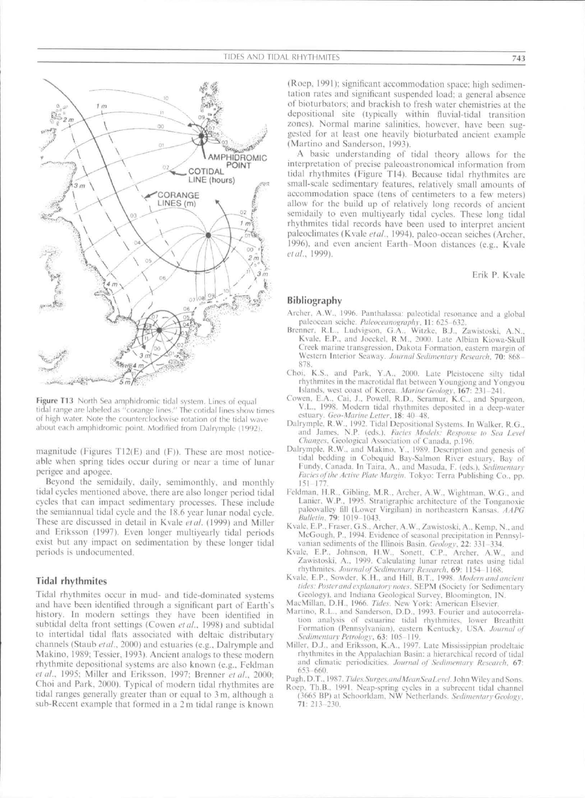
(Figure T13). Becatisc of the Coriolis effect, these discrete (idal
bulges or waves typically rotate about the amphidromic point
in a counterclockwise direction in the northern hemisphere and
clockwise in the southern hemisphere. In an open-ocean
semiditirnal tidal system, a tidal bulge completes one rotation
about an amphidromic point every 12.42 hotn's.
As the open-ocean tides approach continental shelf areas,
tidal energy is concentrated and tidal ranges generally increase
independent of latitude. In some cases, the geometry of an
embayed area along a eoastline is such that the period of
time it takes for a tide to move in and out of the basin is
close to one of the astronomical tidal periods (discussed below)
and significant tidal amplification takes place. An e.xtreme
example o\' this is the Bay of Eundy in eastern Canada where
there is a significant resonant amplification of the open-ocean
tides (generally I m or less) with tides rising and falling up to
16m/day.
Beeause of ihe inadequacy of the eqtiilibrium tidal theory to
explain the complexities of real world tidal systems, ihe
eoncept of harmonie analysis of tidal constituents was
developed and should be considered when attempting to
tinderstand tides (see discussions in Pugh. 1987; and Rvale
euil.. 1999).
742
TIDFS AND TiDAL RHYTHMITES
Tidal cycles
The intensity or height of the daily or twice daily tides can vary
in a number of ways. The semimonthly variations in daily or
semidaily tidal heights are known as neap-spring tidal cycles.
In a semidiurnal tidal system, neap-spring tidal cycles are the
result of the phase changes of the Moon. Spring tides occur
when the Earth. Moon, and Sun arc nearly aligned at new and
full Moon every 14.76 days (Figure T12(B)). Neap tides occur
when the Sun and Moon are aligned at right angles from the
Earth at lirst and third quarter phases ofthe Moon. The result
is that spring tides arc higher than neap tides (Eigure T12(E)).
The lime it takes for the Moon to go from new Moon to new
Moon is called the synodic month, which has a modern period
of 29.53 days.
The tidal force also depends on the declination of the Moon,
the tide-raising force at a given location being greater when the
Moon is closer to the zenith. The period of the variation in
lunar declination is called the tropical month and is the
interval of time it takes the Moon to complete one orbit
movina from ils maximum northerlv declination to its
maximum southerly declination and then returning
{Figure T12(C)). The current length ofthe tropical month is
27.32 days. The efTect of the tropical month in most
semidiurnal systems is to cause the diurnal inequality of the
tides in which the morning high tide is greater or lesser than
the evening high tide. Ideally, the diurnal inequality is reduced
to zero when the Moon is over the equator (Eigure TI2(H)).
However, in alt dominantly diurnal systems having primarily
one tide per day, tropical monthly tides are responsible lor
generating neap-spring cycles every 13.66 days {Eigure
T12(F)). In such cases, the dominant tidal force depends on
the declination of the Moon, with the force being greatest
(thereby generating spring tides) when the Moon is at zenith.
Because the lunar orbit is slightly elliptical, the Moon's
orbital travel carries it between perigee {closest approach to the
Earth) and apogee {farthest distance from the Earth)
(Eigure T12(D)). The period of time for the Moon to move
from perigee to perigee is called the anomalistic month. The
anomalistic month eurrently is 27.55 days. During a lunar
month there are two spring tides that are often of unequal
(C)
NORTH OF EQUATOR
SOUTH OF EQUATOR
(D)
PERK^E
(E)
NtNV IM FuN
i
Qtf
So
New
1U
on
IBl'*'
1.
Fun
Jl
3fa
on
1,]
1
1
Qt»
1
Fun
So
.llM
1
(F)
• 20 40 SO BO 100 120 140 leC 1S0
Figure T12 idealized e(|uilibrium tidal models that illustrate semidiurnal tides (A), the synodic monlh iBl, the tropical month (CI, and the
anumalistk. month (D). Figure T12E depicts
<i
segment of the 1991 predicted high tides from Kvvajalein
Atoll,
Pacific Ocean. Figure
F
depicts a
segmenl of the 1994 predicted high tides from the Barilo River, Borneo. "Su"—Subordinate semidaily tide; "Do"—Dominant semidaily tide;
"C"—Equatorial passage of the Moon (Crossover); "No"—Moun at maximum northern declination; "So"—Moon at maximum southern
declination. Figures modified from Kvale ft ni (1998).
TIDES AND TIDAL RHYTHMITES
743
AMPHIDROMIC
POINT
COTIDAL
LINE (hours)
Figure Tl
3
Norlh Sea amphidromic lidal system. Lines of equal
lid.ll
r.inge
are labeled as "Lurange lines," The colidal lines show limes
ol hij>h waler. Note the (.(Hinlcrt lot kwise rotation of lhe tidal wave
ahoul each amphidromic point. Modified from Dalryniple (1992).
tnaynitiidc (Figures Ti2(E) and (F)), These arc most notice-
able when spring tides occur during or near a time of lunar
perijzcc and apogee.
Beyond the scmidaily. daily, semitnonihly. and monthly
tidal eycles mentioned above, there are also longer period tidal
cycles Ihat can impact sedimentary processes. These include
the semiannual tidal cycle and the IS,6 year lunar nodal cycle.
These arc discussed in detail in Kvale I'tul. (1999) and Miller
and Friksson (1997), Fven longer mulliyearly tidal periods
exist but any impact on sedimentation by these longer lidal
periods is undocumented.
Tidal rhythmiles
lidal rhylhmiies occur in mtid- and tide-dominated systems
and ha\e been identified through a significant part of Earth's
history. In modern settings they have been identified in
snbiidal delta front settings (Cowen etiil.. 1998) and subtidal
to intertidal tidal flats associated with deltaic distributary
channels (Staub eta/., 2000) and estuaries (e.g.. Dalrymplc and
Makino. 1989; Tessier, 1993), Ancient analogs to these modern
rhythmite depositional systems are also known (e.g.. Feldman
eta!.. 1995: Miller and Eriksson. 1997: Brenner tV (//.. 2000;
Choi and Park. lOW). Typical of modern tidal rhythmites are
tidal ratiges generally greater than or equal to
3
m. although a
sLib-Recent example that formed in a 2 m tidal ranuc is known
(Roep. 1991); signilicant aceomtnodation space; high sedimen-
tation rates and significatit suspended load; a general absence
of bioturbators; and brackish to fresh water chemistries at lhe
depositional site (typieally within lluvial-tidal transition
zones).
Normal marine salinities, however, have been sug-
gested for at least one heavily bioturbated ancient example
(Martino and Sanderson, 1993).
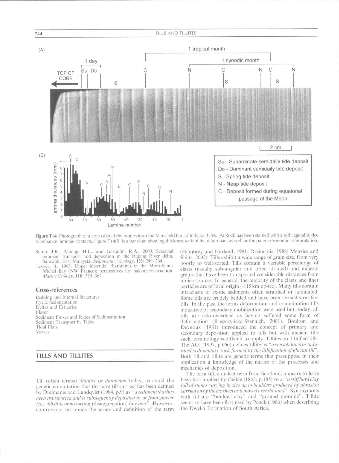
A basic understanding of tidal theory allows for the
interpretation of precise paleoastronomical inlbrmation from
tidal rhythmites (Figure T14). Because tidal rhythmites arc
small-scale sedimentary features, relatively small amounts ol"
accommodation spaee (tens of centimeters to a few meters)
allow for the build up of relatively long records of ancient
scmidaily to even multiyearly tidal eycles. These long tidal
rhythmites tidal records have been used to interpret ancient
paleoclimates {Kvale etal., 1994). paleo-ocean seiches (Archer.
1996),
and even aneient Earth Moon distances (e.g,, Kvale
etal.. 1999),
Erik P. Kvale
Bibliography
Archer. A.W,. 1996, Panthalassu: paleotidal resonaiiL'c and a global
paleoceiin seiche,
Ptilc(iictiitiii;r(ipliy.
11: 625 632.
Brenner. R.L,. Liidvigson. fi,A,, Wilzke. B,J.. Zawisloski. A,N,.
Kvulf,
E,P,. and Jocckc!. R,M,, 2000, Late Albiaii Kiowa-Skiill
Creek m;irinc transgression. Dakota Formation, eastern margin of
Western hilerior Seaway, JoitnuilSctiimcnhtiv Research. 70: SCiK
878.
Choi. K,S,. and Park. Y.A,. 2001), Late Pleistocene silty tidal
rhythmilcs in the maerotidal Hat boiween Youngjongand Yongyoii
Ukmds, west eoast of Korea.
.\larinfGc<ili>i;v.
167: 231 -241,
Cowen. E,A,. Cai. J,, Powell, R,D,. Seranuir, K,C,. and Spurgeon,
V.L,. 1998. Modern tid;il rbyllnnilcs deposited in ii decp-waier
estuary,
Gi'ti-.Maniu-
Letter..
!8: 40 4S,
Dalrymple. R,W,, 19'J2. Tidal Deposiiional Systems, In Walker. R,G,.
and .lames. N,P, (eds.). faeie.s Mtnlels: Re.spoitsv ta Sea Level
C'lhttii'e.y.
Geological Association of Canada. p.l96.
Dalrymple. R.W,. and Makino. Y,. 19X9, Description and genesis of
Iidal bedding in Cobequid Bay-Salmon Ri\er estuary. Bay of
Fund>. Canadii. In Taira. A,, and Masuda. F, (ed.s,). Seilimeiuarv
Faeicscf the Active Plate Mar^n. Tokyo: Terni Publishiniz Co,, pp.
151 177,
Feldman. ELR,. Gibling. M.R,. Arclier. A,W,. Wightman. W,G,. and
Lanier. W,P,. I'J95, Stratigniphie archilectiire ofthe Tonganoxie
paleoviilley till (Lower Virgilian) in iiortheitstern Kansas, AAPG
Btilletiit. 79: IOiy-1043,
Kvale. E:,P,. Fra.ser. G.S,. Archer. A,W,. Zawistoski. .\.. Kemp. N.. and
McGough. P,. 1994. Fvidenee of seasonal precipitation in Hennsyl-
vanian sediments ofthe Illinois Basin. Geologv. IT. 331 334.
Kvale. E,P.. Johnson. H,W,. Sonett. C.P.. Archer. A.W., and
Zawisloski. A.. 1999. Caleukiting lunar retreat rates using lidal
rhythmites. JonrintlaJ .Sciliiinimin Kcsctttch. 69: 1154 1168.
Kvale. E.P.. Sowder. K.H.. and Hill. B.T.. 199S. Modem ami atuicnt
tides: FosievaiulexpUinattxy
notes.
SEPM (Soeiety for Sedimentary
Geology). ;ind Indiana Geological Survey. Bloomington. IN.
MacMillan. D.M.. !966, Tidc\- New York: Ameriean Flsevier.
Marlino, R.L., and Sanderson. D,D,. 1993, Fourier and autocorrela-
tion analysis of eslu;irine tidal rhythmiles, louer Brealhitt
Formation (Pennsylvanian). eastern Kentucky. USA, Joiittuil
<//'
Scdituvntttry Petroli>^y. 63:
U15 119,
Miller. D,J,, and Eriksson. K,A,, 1997, Late Mississippian prodellaic
rliyllimiies in the Appalachian Basin: a hierarchical record of lidal
and elimaiic periodicities. Jutti-ital uj Sedimctitarv Research. 67:
653-660,
Pugh.D,T,, 1987. 7V(/c,v,,V»(-.t;(',s,(;"(/,'V/ci;/j.S'rt;Z.i'iW, John Wiley and Sons,
Roep.
Th,B,, 1991, Neap-spring cycles in a subreceni tidal channel
(366? BP) at Schoorldiim, NW Nelherlands. ScdimetUarvGeology,
71:
213-230.
744
TILLS AND TILLITES
(A)
1 tropical month
1 synodic month
N C
2 cm
(B)
Su - Subordinate semidaily tide deposit
Do - Dominant semidaily tide deposit
S - Spring tide deposit
N - Neap tide deposit
C - Deposit formed during equatorial
passage of the Moon
50 40 30
Lamina number
Figure Tl
4
Ph{)lugraph of a core oi tidal rhylhmiles irom the Manslield Fm, of Indiana, USA. (A) Rock has been slained with a red vegetable dye
to enhance laminae contacts. Figure T14lB) is
<i
bar charl showing ihickness variabilily ot' laminae, as well as the paleoaslronomic interpretation.
Slaub.
J,R,. Among. H.L.. and Gastaldo. R,A,. 20(10, Seasonal
sediment transport und deposition in the Rajaiig River deltii.
Sarawak, East Malaysia. Srdiificuldry
(n-clof^y.
133: 249 264,
Tessier. H.. 1913. Upper iiilenidal rhythmiles in llic Moiu-Saini-
Michel B;i\ (NW
France}:
perspecti\cs I'or palcorfcdiistriiction.
Marine Geology. 110: 355-367,
Cross-references
Bedding and Iniemal Siriictiires
Cyclic Sedimeiilation
Deltas and Fstuaries
Flaser
Sedimeni Fkixes and Rates of Sedinieniaiion
Sedimeni Transport by Tides
Tidal Flals
Varves
TILLS AND TILLITES
Till (often termed diamiet or diamlcum today, to avoid the
genetic connolation that the term till carries) has been delined
by Dreinianis and Lundqvist (1984. p,^) as "asedimentlliailui.s
been Inuisporlcd and is
suh.set/nemly
deposited by or fnini
i^kieier
ice.
with
little orno.sorn'ng
(disaggregation) bywater". However.
controversy siirrotinds the usiige and definition of lite term
(Hambrey and Harland. I9S1: Dreimanis, 198S; Menzies and
Shilts,
2002). Tills exhibit a wide range of grain size, from very
poorly to well-sorted. Tills contain ii variable percentage of
eUtsts (tisually sub-angular and often striated) and mineral
grains that have been transported considerable distances from
up-ice sotirces. In general, the majority of the elasts and finer
partieles are of local origin (<
15
km up-ice). Many tills contain
intraclasts of exotic sediments often stratified or laminated.
Some tills are crudely bedded and have been termed stratified
tills.
In the past the terttts deformation and eomminution tills
indicative of secondary mobilization were used but, today, all
tills are acknowledged as having sutTered some form of
deformation (Ruszezyiiska-Szenajch. 2001). Boulton and
Deynoux (1981) introduced the concept ol" primary and
secondary deposition applied to tills but with ancient tills
sueh terminology is difficult to apply. Tillites are lithified tills.
The AGI (1997, p.666) defines tillite as
^'a
cousolidaled
or
indu-
rated .sedimrntarv roek formed hy the lithipcaiitm of iilaeiul till".
Both till and tillite are genetic tertns that presuppose in their
application a knowledge of the nature of the processes and
mechanics of deposition.
The term till, a dialect term from Scotland, appears to have
been first applied by Geikie
(1863,
p,l85) to a "a.stiffhurdelay
full
oJ
stones
varvin,'^
in size up lo boulders produeed hy
abra.sion
carried on
h\-
the
iee
sheet
as
it moved
over
the
land".
Synonyrnotis
with till arc "boulder elay" and "ground moraine". Tillite
seems to have been first used by Pcnck (1906) when describing
the Dwvka Formation of South Africa,
