Marjoribanks R. Geological Methods in Mineral Exploration and Mining
Подождите немного. Документ загружается.

9.3 Gravity Surveys 149
of the underlying rocks. In particular, different granite suites may have distinctive
radiometric ratios.
In developed countries, regional, relatively small-scale magnetic maps are usu-
ally flown by the government and are available in digital form or standard map-sheet
format (as contours or pixels) from government survey agencies. Such maps may not
be very detailed but generally do provide a comprehensive regional overview. Large
exploration groups will often contract to fly their own aeromagnetic surveys over
their tenements at increasingly detailed scales. In some established mining camps,
geophysical survey companies have flown large areas of detailed magnetic imagery
on a speculative basis, and they offer these data (or sub-sets of them) for purchase
by mineral explorers.
9.3 Gravity Surveys
Gravity surveys measure lateral changes in the density of subsurface rocks. The
instrument used, called a gravimeter, is in effect an extremely sensitive weighing
machine. By weighing a standard mass at a series of surface stations, the gravimeter
detects minute changes in gravity caused by crustal density differences. Maps of
gravity variation can hence be used to map subsurface distribution of rocks and
structures, including the anomalous density distributions that might be associated
with concealed ore.
To provide usable data, raw gravity measurements need to be corrected. The first
correction (for short-term drift in the instrument) is provided by regular reading of
a base station in much the same manner as a magnetic survey. The second correc-
tion compensates for the broad scale variations in the earth’s gravitational field –
this correction is only significant in regional surveys. The third correction, much
the most important one, corrects for differences in gravity caused by variation in
the elevation of the survey station above a datum, usually sea level. To make this
correction, stations need to be levelled with great precision – in the case of a very
broad regional survey to at least one metre; in the case of a detailed survey aimed at
direct ore location, to correspondingly greater accuracies, down to centimetre scale.
The costs involved in the very accurate surveying necessary for altitude correc-
tion has, until recently, generally restricted the use of gravity surveys in mineral
exploration to low-density, broad-scale, regional coverage. However, differential
GPS (DGPS) surveying now allows rapid and relatively cheap levelling of stations
and has made detailed gravity surveys comparable in cost to that of ground-magnetic
surveys.
A good example of the successful use of a gravity survey as an aid in ore dis-
covery is the location of the high-grade Hishikari epithermal gold deposit of Japan
(Izawa et al., 1990). Here, a detailed gravity survey was used to define a buried
mineralized structure in an area of known mineralization. The key to the success-
ful use of the technique in this case was the high degree of understanding of the
local geology and mineralization, which was used in the design and interpretation
of the survey. Gravity surveys (along with regional aeromagnetic data) also played
150 9 Geophysical and Geochemical Methods
a significant part in the discovery of the giant deeply buried Olympic Dam (Rutter
and Esdale, 1985) and Prominent Hill (Belperio et al., 2007) IOCG deposits of South
Australia.
Modelling of the gravity response for the likely range of size, depth, and SG
of targets is an important reality check before the technique is used for direct
exploration. In some Australian regolith settings, undefined geometries of variable
density material in the regolith can produce ambiguous gravity results and spurious
anomalies.
9.4 Radiometric Surveys
These surveys measure the natural radiation emitted by rocks at surface. The data
are collected and presented in a similar way to magnetic data. Radiometric mea-
surements are often carried out from a low-flying aircraft at the same time as air
magnetic surveys. Radiometric measurements can also be taken with land-based
instruments that can be used at ground stations or lowered down drill holes. The
instrument used is called a spectrometer.
The most abundant naturally occurring radioactive element in the crust is the
potassium isotope
40
K, largely incorporated into the crystal structure of the rock-
forming mineral orthoclase. Of lesser importance as a source of radiation is
thorium (found in monazite, an accessory mineral of some granite and pegmatite
bodies). The radioactive mineral normally sought by explorers – uranium – is sel-
dom abundant, but at low concentrations can characterize particular rocks such as
highly fractionated granites or some black shale sequences. Spectrometers provide
selectable channels so that radiation derived from these different sources can be
distinguished. Since most natural radiation comes from potassium, maps of total
radiation count provide a very effective way of mapping the distribution of alkalic
igneous rock and of sediments (such as arkose) derived from these rocks. Monazite
weathers from bedrock to form a resistant heavy detrital mineral that often accumu-
lates in watercourses or strand lines. For this reason, these features often stand out
on the thorium channel of radiometric maps. Maps presenting ratios of radiometric
measurements made in different channels, such as U/Th and K/U can be very useful
for discriminating different rock types. Different granite suites may have distinctive
radiometric ratios. Radiometric images have no depth penetration and depend on
signals from surface materials, so they can be particularly useful in adding value to
regolith maps.
9.5 Electromagnetic (EM) Surveys
Electromagnetic surveys aim to measure the conductivity of rocks, either by making
use of naturally occurring electromagnetic fields in the crust, or by applying an
external electromagnetic field (the primary field) and inducing a current to flow in
9.6 Electrical Surveys 151
conductive rocks below. Passing an alternating current through a wire or coil, which
is either laid out along the ground or mounted in an aircraft flying overhead, provides
the primary field. The current induced in conductive rocks produces a secondary
field. Interference effects between the primary and secondary fields provide a means
of locating the conductive rock body.
Since many massive metal sulphide ore bodies are significantly conductive, EM
techniques are mostly used as direct ore-targeting tools in the search for this type of
deposit.
EM systems work best for ore bodies within 0–200 m of the surface. Although,
theoretically, larger primary fields and more widely spaced electrodes can give much
deeper penetration, the problems of interpreting the results of EM surveys go up
exponentially with increasing depth of penetration.
Ground based EM techniques are relatively expensive procedures that are appli-
cable to defining drill targets for specific mineralization styles within established
prospects or highly prospective belts. EM systems are available which can be used
down drill holes to measure the effects of currents flowing between the hole and the
ground surface or between adjacent holes. Airborne systems have been used both
for direct ore location and for regional geological mapping purposes.
Problems in interpreting EM surveys arise because many host rocks to min-
eralization can give a similar geophysical response to the mineralization itself.
Water-filled fault lines, graphitic shales and magnetite-rich zones all can give spu-
rious conductivity anomalies. Deep weathering or salty groundwater can make EM
surveys either unworkable or at least very difficult to interpret. For this reason, EM
surveys have had most success in locating ore in those parts of the world where
fresh, unoxidized rocks occur close to the surface. These conditions occur, for exam-
ple, in the recently glaciated areas of North America, northern Europe and Russia.
Notable successes where airborne EM techniques have played a major role in dis-
covery include the massive sulphide deposits of Kidd Creek in Canada (Bleeker and
Hester, 1999) and Crandon in the United States (Lambe and Rowe, 1987).
9.6 Electrical Surveys
Electrical surveys are all ground based. In their simplest form, they put an electric
current directly into the ground and measure, by means of arrays of receivers, the
resistance of the rocks through which the current passes. Such surveys are therefore
often called resistivity surveys. Current is normally conducted through the ground
by the movement of charged ions in pore fluids. Metallic sulphides, which can con-
duct electric current electronically, can often be detected as zones of anomalously
low resistance.
IP is a special type of electrical survey that utilizes the electrochemical (galvanic)
effects caused by a current passing through disseminated metal sulphides. The cur-
rent creates an electro-chemical charge on the boundaries of the sulphide grains
where the flow of current changes from ionic to electronic (and vice versa). Such

152 9 Geophysical and Geochemical Methods
rocks are said to be chargeable. When the primary current is switched off, the decay
of this secondary voltage can be detected, and so provides a measurement of the
size and position of the chargeable body. Induced polarization is virtually the only
geophysical method that is capable of directly detecting concealed, disseminated
sulphides in the ground. After magnetic surveys, the induced polarization (IP) tech-
nique is one of the oldest geophysical methods to be used in mineral exploration
with the first patent application (by the Frenchman Conrad Schlumberger) being
filed in 1912 (Mathews and Zonge, 2003).
In IP surveys, results are normally presented in the form of pseudo-sections.
Such “sections” are merely a convenient way of representing the electrical measure-
ments and the contoured shapes of the data on them reflect measurement geometry
5
rather than the geometry of the causative body. Such “sections” cannot be readily
equated with a real geological section and need to be interpreted by a specialist geo-
physicist. However, the use of modern inversion modelling software (see following
section) will hopefully make IP pseudo-sections a thing of the past. An example of
the successful use of an IP survey is in the discovery of the blind, sediment-hosted,
lead/zinc sulphide Gortdrurn deposit of Ireland (Hitzman and Large, 1986). The
San Nicolas VMS deposit in Mexico was also discovered as a result of an IP survey
(Johnson et al., 2000).
Electrical surveys require a generator capable of delivering a high voltage and
electrodes placed directly into the ground to transmit the input current. Arrays
of receivers laid along the ground measure resistivity or chargeability. The sur-
veys are relatively expensive and labour intensive techniques. They are therefore
used as direct ore-targeting tools in established prospects where the presence of
disseminated metallic sulphide ore is suspected.
Problems in using electrical surveys can be caused by the short-circuiting effects
on the input current that can be caused by salty near-surface groundwater in deeply
weathered terrain. Problems in interpretation result from the fact that many zones
within rocks, other than bodies of massive or disseminated sulphides, have low
electrical resistance or are chargeable.
Electrical methods, as with electromagnetic methods, work best in the upper few
hundred metres of the surface in areas where recent uplift and erosion, or glaciation,
has produced fresh unweathered rocks relatively close to the surface.
9.7 Hybrid Electrical and Magnetic Surveys
These techniques put an electric current (the primary current) directly into the
ground via a pair of buried electrodes in much the same manner as for a conventional
electrical survey. However, rather than measuring the return voltage with another set
of ground electrodes, a magnetometer is employed to measure the magnetic fields
5
Anomalies appear as a characteristic inverted V shape, informally referred to as a “pants leg”
anomaly.

9.8 Advances in Instrumentation and Data Modelling 153
that are induced by the primary and secondary currents. This creates much faster
and cheaper survey logistics than conventional EM or IP, since the return signal can
be measured at a distance. The variations in the induced magnetic fields can be mea-
sured and analysed in both space and time. The technique is capable of producing
magnetic, resistivity and chargeability data in one survey operation. The techniques
are also capable of measuring return signals in areas where conductive surface over-
burden prevents ground-contact surveys from obtaining meaningful information.
Placing the primary current electrodes along the strike of any postulated mineralisa-
tion channels the current along the conductive body and so increases the magnetic
signal.
With the MMR/MIP technique (Howland Rose, 1984), the magnetic field
induced by the primary current is used to measure the Magnetometric Resistivity
(MMR) of the ground through which the current has passed. The secondary mag-
netic field that is induced by galvanic effects on the contacts of chargeable material
(i.e. disseminated sulphides) is used to calculate the Magnetic Induced Polarisation
(MIP) of the return current path. The results are usually presented as contour or
pixel plans which can be interpreted like a geological map to allow deductions as to
the shape and size and possible causation of any anomalous bodies.
The Sub Audio
6
Magnetics technique or SAM (Cattach et al., 1993) is an evolu-
tion/ development of MMR/MIP that makes use of modern sophisticated electronic
equipment and computing power to increase the rapidity of field surveying and
the definition and resolution of the results. SAM surveys offer very high defini-
tion measurements by the use a rapid sampling total field magnetometer (capable
of 200 readings per second) that acquires sub-meter measurements while continu-
ously traversing either on foot, by vehicle or even helicopter. The products (with
unpronounceable, jaw-cracking acronyms) of a single SAM survey can include:
total field high definition magnetics (TFHDM), total field magnetometric resistivity
(TFMMR), total field magnetometric induced polarisation (TFMIP) and total field
electromagnetics (TFEM). The TFMMR detects variations in the strike direction
of the transmitter electrodes so can be a uniquely efficient mapper of the more
conductive regions of the subsurface such as paleochannels or zones of deeper
weathering. These responses may mask the more subtle signals from conductive
bedrock lithologies or metallic ores.
9.8 Advances in Instrumentation and Data Modelling
The most significant advances in geophysical exploration for mineral deposits in
the last 10 years (since the first edition of this book) have occurred not so much in
advances in theory or practice but rather in the development of more sophisticated
instrumentation and more powerful data processing.
6
Sub-audio refers to the frequency of the input electrical signal. Though perhaps not the most
characteristic aspect of the technique, it does allow for an easily remembered acronym.

154 9 Geophysical and Geochemical Methods
New instruments take advantage of the ever increasing compactness, processing
speed, memory capacity and cheapness of electronic chips. This allows for increased
sophistication in collecting data in the field and for the processing of data at the
moment of collection so as to improve such things as signal to noise ratio. Combined
with the use of DGPS for survey control, these advances have greatly reduced the
cost and time involved in all geophysical surveys, while at the same time increasing
their resolution in the detection of anomalous signals in the data. The exponential
pace of improvement
7
of microprocessor technology shows no sign of abating.
Traditionally, most geophysical data has been presented for interpretation in the
form of contoured or raster plans and sections that can be interpreted in a qualitative
way by a geologist or geophysicist in terms of the geology and ore mineralisation
that they represent. Over the last 10 years, reflecting the ever increasing capacities of
computer processing power, new methods of analysing and presenting geophysical
data – whether magnetic, electrical, gravity or seismic – have been introduced that
are beginning to revolutionise the interpretation process. These methods are gen-
erally referred to as data inversion (McGauchy, 2007; Oldenberg and Pratt, 2007).
Inversion techniques make use of complex computer algorithms, and information
of the geophysical properties of the rocks and potential mineral deposits of the
prospect, to construct mathematically a geological model that agrees, or is at least
compatible, with the geophysical observations. The results are presented as a 2-D
or 3-D geological model of the body of rocks that were surveyed. The end prod-
uct can be quite dramatic and can lead to new insights about the geology of the
survey area. However, it is important to realise that, as with all computer models,
the product of inversion modelling is only as good as the geological choices made
in setting up the model parameters, and the accuracy of the geophysical properties
that are used in its construction. It is a feature of geophysical inversion models that
they are not unique: many different models can be constructed that will reproduce
the geophysical pattern that was measured in the field. Choosing between different
possible models requires geological knowledge about the area, and the better that
knowledge, the more useful and realistic the inversion model. If the model does not
make geological sense then it must be discarded and a new one constructed. The
person with the appropriate knowledge to audit the inversion model is the project
geologist, who needs to work closely with the specialist geophysicist to get the most
out of the data inversion modelling process.
It is well worth bearing in mind the cautionary words of Kenneth Zonge about
computer created geological models (Mathews and Zonge, 2003):
A note of caution ... we must be diligent in determining whether results make good geo-
logical sense, as the computer can create beautiful, mathematically correct, color sections
that do not accurately reflect geology or mineralisation.
7
This development was predicted in 1965 by Gordon E. Moore – a co-founder of Intel – and has
come to be known as Moore’s Law. The “Law” states that the numbers of transistors that can be
placed on a chip will double every 2 years. So far it has held good, although no exponential trend
can ever be projected indefinitely.

9.9 Stream Sediment Sampling 155
9.9 Stream Sediment Sampling
Active sediments in the channels of streams and rivers can contain low levels of met-
als derived from weathering of mineralized rocks within the upstream catchment.
This simple fact is the basis for stream sediment sampling – one of the most widely
used methods in regional geochemical prospecting. The technique has played a
major part in the discovery of many ore bodies, a good example being the discov-
ery of the Panguna porphyry copper/gold deposit on Bougainville Island, Papua
New Guinea (Baumer and Fraser, 1975). For the technique to work with maximum
effectiveness, ideally the following conditions should be met:
• The area should be one of active erosion with an incised drainage pattern.
• The ideal sample point is on a primary drainage with a relatively small upstream
catchment. Even very large anomalies are rapidly diluted in secondary or tertiary
streams.
• Only the active sediment on the stream bed should be sampled. Bank material
may be locally derived and not representative of the whole catchment.
• In the absence of an orientation survey to define the ideal sample size fraction,
the silt fraction of the stream sediment (usually specified as –80 mesh
8
) should
be collected. In fast flowing streams a large volume of sediment may have to be
sieved in order to collect a sample of suitable weight for assay (at least 50 g but
preferably 100 g is needed). Sieving therefore has to be done at site and is best
done by washing a grab sample through the mesh of the sieve. The most rugged
and best sieves for field use are made of stainless steel with stainless steel mesh
(Fig. 9.1g). Sieved samples are usually stored in small Kraft paper envelopes with
sealable fold-over tops (Fig. 9.2c, d).
• As much detail as possible about the sample site should be recorded. As a mini-
mum this will include the following information: stream width and flow, nature of
the coarse float and nature of any outcrop present. This information will be invalu-
able when the assay results are later analysed and potential anomalous values
selected for follow-up.
• Follow-up of anomalies will usually take the form of stream sediment sam-
pling upstream, along the anomalous drainage, to define the point of entry of
the anomalous metal to the stream sediment. Further definition of the source can
then be carried out by means of soil sampling on the slopes above the anomalous
drainage.
8
This is called the Tyler mesh number and refers to the number of mesh openings per linear inch.
The maximum fraction size that will pass through a mesh defined in this way obviously depends on
the diameter of the material used for the mesh itself, but for standard laboratory sieves the openings
in a –80 mesh sieve are approximately 180 μm or 0.018 mm (Weiss, 1985). For a more detailed
treatment of sieve sizes see Field Geologist’s Manual published by the Australasian Institute of
Mining and Metallurgy – 3rd Edition, 1991.

156 9 Geophysical and Geochemical Methods
(a)
(b)
(
e)
(f)
(g)
(c)
(d)
Fig. 9.1 Some tools for collecting geochemical samples. (a) Hand auger. The sample is col-
lected from the barrel on pulling tool from the ground. Extension rods can be added to the shaft.
(b) A screw or Archimedean auger and bit. Powered by a small petrol or diesel engine, cuttings are
brought to surface along the flights. The drill is generally mounted on the back of a light vehicle.
(c) An electric hand operated rock saw with a diamond blade for cutting channels in rock outcrop.
(d) A pelican pick – surface soil samples can be collected without stooping and slid easily into
asamplebag.(e) The standard geologists’ rock chip sampling equipment. (f) A panning dish for
collecting a heavy mineral concentrate. (g) Stainless steel sieve and collection pan. For stream
sediment sampling a –80 mesh sieve size if commonly used
9.10 Soil Sampling 157
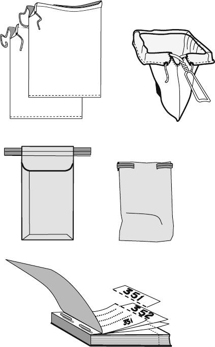
(b)
(e)
(d)
B 351
(c)
(a)
Fig. 9.2 Consumables used in the collection of geochemical samples. (a) Cotton sample bag
with draw string top for holding rock chip samples. (b) Simple wire frame turns sample bag in
a catching device when taking rock chip samples from outcrop. (c)and(d) Kraft paper envelope
(100 × 50 mm) with fold-over sealable top for collection of wet sieved stream sediment samples.
(e) Sample book with pre-printed sample numbers. Tear-off strip goes with the sample. Sample
details (location, sample type, description etc...) are recorded on the retained tag
9.10 Soil Sampling
This technique relies on the fact that metals derived from the weathering of sub
cropping ore often form a wide, near surface dispersion halo around or adjacent
to, the deposit. With the ability of chemical analysis to detect very low element
abundance, a regularly spaced sampling grid can thus locate the surface “footprint”
of the ore body. Significant anomalies may be of the target metal or of elements that
are known to be associated with the style of mineralization sought.

158 9 Geophysical and Geochemical Methods
As a relatively expensive technique, soil sampling is typically employed in the
detailed exploration of prospective mineral belts or established prospects, where it is
used to define specific targets for follow-up drill testing. A good recent example of
the successful use of the method is the discovery of the Century sediment-hosted
zinc deposit in the Mount Isa District of Queensland, Australia (Broadbent and
Waltho, 1998).
The sample collected for assay is usually the fine silty or clayey surface mate-
rial that results from weathering of the underlying bedrock and may contain small
fragments of bedrock. A coarse sieve (–10 mesh) may be necessary to remove over-
large fragments before taking the sample. The sample is normally taken from just
below the organic-rich surface grass-roots layer. A small pick or mattock is used
for this job – the “pelican pick” (Fig. 9.1d) – is ideal as it allows the sample to be
collected without stooping and slid easily into a sample bag with minimum han-
dling. In some areas (such as rain forest) a hand auger (Fig. 9.1a) may be needed to
obtain the sample. Samples are normally stored in calico bags with draw-string tops
(Fig. 9.2a).
Not all soils are in situ residual accumulations of weathered bedrock. They may,
for example, have been transported for some distance laterally from their source
by the action of gravity, wind or rain. The soils may be part of a landscape with a
long history of evolution. That history might have involved variable water tables and
cycles of chemical enrichment and depletion. To adequately interpret the results of a
soil survey it is therefore essential to have an understanding of the regolith
9
of which
they are a part. Regoliths can have long and complex evolutionary histories and need
to be geologically mapped and interpreted prior to planning a soil geochemistry
survey, in order to define those areas suitable for this type of sampling.
In gold exploration, very low concentrations of the metal in soil samples can
be determined by employing the Bulk Leach Extractable Gold – or BLEG – assay
technique. In this method, a large sample (2–5 kg) of silt sized material is digested
for several days in a sodium cyanide solution to extract all contained gold. The
solution is then assayed for gold. Because all the gold from a large sample size is
extracted, it is possible to obtain an assay for the original sample at the parts per
trillion level (ppt).
9.11 Heavy Mineral Concentrate (HMC) Sampling
Panning stream sediments to extract any heavy mineral component is an ancient,
but still very relevant and effective, geochemical prospecting technique. The heavy
mineral concentrate (HMC) can be examined at the collection site to identify and
9
Regolith refers to the surface layer or layers of unconsolidated soil and rock fragments that overly
bedrock. It may be derived directly from weathering of underlying rock (residual regolith) or been
transported to its present site by surface agents such as wind, water, down-slope creep or human
activity.