Hess Earl J. Field Armies and Fortifications in the Civil War: The Eastern Campaigns, 1861-1864
Подождите немного. Документ загружается.

118 From Seven Pines to the Seven Days
immediately in front of the position compensated for the meager size and
profile of the works.
≥∏
Milroy was not deterred by these fortifications. ‘‘I will hist them out of that
as soon as I get the ballance of my forces up,’’ he crowed to his wife. His men
pushed past the village of McDowell and advanced nine miles farther east to
the foot of Shenandoah Mountain, where they skirmished with Johnson’s
pickets. Milroy climbed a high ridge two miles away on April 18, a clear
day, and could see the Confederate fortifications with the naked eye. John-
son also saw him and worried that the Federals could easily outflank his
strong position. He evacuated Shenandoah Mountain on April 19 and retired
to Staunton. The Federals continued their pursuit the next day and skir-
mished with Rebel cavalry for ten miles. The van of Milroy’s column reached
nearly to Staunton itself before the aggressive general finally pulled back to
McDowell to await reinforcements from other Union columns still moving
through the mountains.
≥π
News of Milroy’s advance alerted Jackson to the need to safeguard his
western flank. He feigned an evacuation of the Valley, moved his men to
Staunton by rail, and then marched across the mountains. One can truly
appreciate this accomplishment by driving along Highway 250 from Staun-
ton, which is the route of the old Staunton-Parkersburg Turnpike. Jackson
crossed Great North Mountain, the western edge of the Valley, through a
wide and deep gap about twelve miles west of Staunton. Then he crossed
Calfpasture River. Milroy had moved most of his command back to the west
side of Shenandoah Mountain by May 5, but he left the 32nd Ohio at the foot
of the east slope. Part of Jackson’s command skirmished with the Ohioans on
May 7 and forced them to head for McDowell. This alerted Milroy to Jack-
son’s presence. Brig. Gen. Robert C. Shenck joined Milroy at McDowell with
three infantry regiments and a battery on the morning of May 8. The Con-
federates continued their advance over Shaw’s Fork, Shaw’s Ridge, and Cow-
pasture River and onto the top of Bullpasture Mountain. McDowell lay in the
next valley, formed by Bullpasture River.
≥∫
Milroy shelled the Rebels for much of the day and then attacked. Bitter
fighting took place on top of Sitlington’s Hill, which was connected to Bull-
pasture Mountain on the east side of the valley. It took place in a cleared
field and through the woods and ended in a draw. The Federals conceded
defeat, retreated from the battlefield, and prepared to retire to Franklin.
About 256 of 6,000 Federals fell at McDowell, while Jackson lost 500 of his
9,000 men.
≥Ω
McDowell was the only engagement of the Shenandoah Valley campaign
that was fought on Appalachian terrain; the remaining battles took place
From Seven Pines to the Seven Days 119
inside the Valley. Jackson next turned his attention to a Union force under
Maj. Gen. Nathaniel P. Banks, stationed in and around Strasburg near the
lower end of the Valley. The Federals had built a redoubt on a command-
ing hill just outside town, but it was not designed to accommodate Banks’s
9,000 men. Jackson outflanked the Federal position by moving through
Front Royal on May 23 and drove Banks from Strasburg to Winchester,
twenty miles away. Further operations drove the Federals into Maryland.
∂≠
The drive to McDowell and the strike at Strasburg were the only two
instances where fortifications played a role in Jackson’s Valley campaign,
and in both instances that role was marginal. In neither case did earthworks
affect the outcome of the engagements. The rest of the Valley campaign that
year saw Jackson’s greatest triumph in the battles of Cross Keys and Port
Republic, on June 8 and 9. Here Jackson defeated two converging Federal
columns in classic Napoleonic fashion. Soon after, his jubilant men were
ordered to Richmond and left the Valley on June 17. In thirty-five days he had
marched 245 miles, fought four battles, and won them all.
∂∞
The Seven Days
Lee mustered 85,000 men for his planned offensive, the largest number
ever to serve in the Army of Northern Virginia, while McClellan had 104,300
men at his disposal. The Confederates accomplished an admirable goal,
bringing the majority of their strength against the enemy’s weakest point.
Lee launched 56,100 men against Porter’s 28,100, while leaving 28,900 Reb-
els south of the Chickahominy to oppose McClellan’s four corps, consisting of
76,200 troops. Only the Union general’s innate caution and the heavy earth-
works recently constructed by the Confederates made this plan feasible.
∂≤
The receipt of Lee’s plan, issued in General Orders No. 75, ‘‘profoundly
impressed’’ Joseph L. Brent, Magruder’s staff officer. ‘‘Here, thought I, is the
most momentous act of war ever revealed to me. This is the opening of the
great game which will probably decide the fortunes of the Confederacy.’’
After their lengthy retreat, failed attack at Seven Pines, and month-long
spate of digging, the men of Lee’s army were desperate for a chance to whip
the Yankees, and Granny Lee now seemed to be made of bolder stuff than
anyone had imagined.
∂≥
McClellan spent the month of June improving his defensive works. His
own plans to enter Richmond were similar to those employed at Yorktown:
to rely on earthworks and his superior artillery to minimize casualties. Den-
nis Hart Mahan had called such a tactic an ‘‘ ‘active defense’—in effect, an
advance toward battle from behind his own field fortifications.’’ It promised
a long campaign, but one that Lee and Davis thought eventually would be
120 From Seven Pines to the Seven Days
successful. McClellan believed he was outnumbered two to one and used
that fallacy to justify his entrenchment to Lincoln. He wanted to ‘‘bring the
greatest possible numbers into action & secure the army against the conse-
quences of unforseen disaster.’’ The general viewed his objective as a daunt-
ing one. ‘‘The rascals are very strong,’’ he wrote his wife, ‘‘they are well
intrenched also & have all the advantages of position.’’
∂∂
In the days preceding Lee’s attack, orders went out from McClellan’s
headquarters to strengthen the works south of the Chickahominy. The Sec-
ond and Third Corps were to ‘‘cut as much timber as possible in front of their
positions.’’ Parapets were strengthened and ditches were deepened. The
19th Massachusetts, in the Second Corps, had a parapet that was four feet
high, three feet wide at the top, and seven feet wide at the bottom. There
were enough men to place two ranks behind this respectable barrier. Man-
ning these works while the generals developed their strategy was boring,
thought Lyman Blackington, but the men spread their rubber blankets over
poles for shelter from the sun and rain.
∂∑
The Seven Days campaign began when Lee made his initial strike against
Porter. His plan called for a frontal and flank approach to the Union position,
which had been strongly fortified. The Federals had constructed a line of
works on the east side of Beaver Dam Creek, one mile east of Mechanicsville.
The line covered the western approaches, which were flat, open fields be-
tween the creek and the town. At least two artillery emplacements covered
crossings of the creek over the dam at Ellerson’s Mill and the main road from
Mechanicsville to Bethesda Church. Porter called this position ‘‘naturally
very strong.’’ The banks of Beaver Dam Creek were steep and some sixty feet
high, and the water in the stream was waist deep. The bottomland was 200
yards wide and very swampy near the mouth. The creek valley narrowed and
became more shallow as one went northward, upstream from its junction
with the Chickahominy River.
The creek was a good obstruction that constituted the main feature of the
battlefield, but the works themselves were modest by later standards. The
line was placed at the lower end of the creek bluff, near the edge of the
bottomland, and had a parapet that was chest high with a post-and-plank
revetment. The trees in the creek valley were cut down to clear a field of fire
and create a slashing. One of the artillery emplacements remains; it is a
simple work, a straight parapet 20 yards long with a good ditch. Faint evi-
dence of two embrasures can be seen. There is a 30-yard remnant of a
supporting infantry line to the left of this emplacement, with a parapet and a
shallow trench, but no ditch in front. This artillery emplacement is to the
rear of Porter’s main line, about 150 yards from the irregular lower edge of
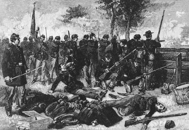
From Seven Pines to the Seven Days 121
Federal works at the battle of Mechanicsville. This dramatic illustration shows the
Union line of battle fighting from behind modest works. Note that there is no protection
for the upper part of the body. (Johnson and Buel, Battles and Leaders, 2:327)
the slope and about 50 yards down from the top of the creek bluff, which has
a very gentle incline. The line of works was one and a half miles long on the
east side of Beaver Dam Creek and manned by three brigades of Brig. Gen.
George A. McCall’s division of Pennsylvania Reserves, some 9,500 men, sup-
ported by thirty-two guns.
∂∏
Lee hoped to flank Porter out of his position. Jackson was to accomplish
this task, but for reasons that still intrigue historians, he failed to do so.
Jackson’s column struggled to a point within a few miles of the battlefield be-
fore bivouacking on the evening of June 26. Impatient to go in, Lee’s men
launched frontal attacks that afternoon. Some 11,000 Confederates eagerly
stormed the works and were ripped to shreds. First they struck McCall’s
right wing, upstream. Then Daniel Harvey Hill sent two brigades under
Pender and Brig. Gen. Roswell S. Ripley against Porter’s left wing, with
equally devastating results. The green troops thought little of the dan-
ger and exposed themselves unnecessarily. Nowhere did they come close to
penetrating the line. A Virginia officer who crossed the battlefield the next
day wrote that it was ‘‘literally covered with our dead soldiers.’’ Many bodies
lay within twenty yards of the works, but most littered the swampy bottom-
land. The Confederates lost 1,475 men, while the Federals tallied a loss of
122 From Seven Pines to the Seven Days
only 361 men. ‘‘It was not war,’’ one Pennsylvania infantryman later re-
marked, ‘‘it was murder.’’
∂π
‘‘We were lavish of blood in those days,’’ Daniel Harvey Hill was to ad-
mit, ‘‘and it was thought to be a great thing to charge a battery of artillery
or an earth-work lined with infantry.’’ The men of Pender’s and Ripley’s
brigades had no idea how strong Porter’s works were, or of the difficulties
they would encounter while struggling across Beaver Dam Creek. Not only
were many good men wasted, but the battle ‘‘had a most dispiriting effect’’
on the survivors. With hindsight, it became easy for Hill and others to see
that Lee should have waited until June 27 to allow Jackson more time to turn
Porter’s flank.
∂∫
The irony is that although the Confederates suffered a tactical defeat,
they won a strategic victory at the battle of Mechanicsville, also called the
battle of Beaver Dam Creek. McClellan had visited Porter’s fortified position
early in the afternoon of June 26. When he left just before Lee attacked, he
still had not decided whether to evacuate the position. At 3:00 a.m. of June
27, the order to pull out reached Porter. McClellan ignored the bloody re-
pulse and decided the Fifth Corps should retreat six miles eastward to the
vicinity of Gaines’s Mill, where a semicircular line had already been sketched
out by Barnard. The new position better protected several crossings of the
Chickahominy, thus securing the connection between the two separated
wings of McClellan’s army.
∂Ω
McClellan threw away a superb defensive position and all the morale
advantages gained by Porter’s victory. James Longstreet, whose troops had
wasted themselves in the attack, thought the Federals should have rushed up
reinforcements and dug additional works to cover Porter’s flank during the
night of June 26–27, to make the strong position impregnable. Longstreet
noted that only the bloody attacks at Malvern Hill dispirited his troops more
than the drubbing they received on June 26. The Federal withdrawal re-
inspired them, and they fought ferociously the next day at Gaines’s Mill.
Although light in nature, Porter’s earthworks and the obstruction presented
by Beaver Dam Creek had played key roles in determining the outcome of the
battle of Mechanicsville. The true waste was committed by McClellan with
his decision to retreat.
∑≠
Porter’s new position at Gaines’s Mill was strong in many ways. It em-
braced ‘‘a largely open, oval-shaped plateau’’ from 40 to 80 feet above the
surrounding countryside and at 150 feet elevation. The position was two
miles wide and one mile deep. Most of the land inside the Union semicircle
was open and cultivated. Elder’s Swamp shielded the right, and Boatswain’s
Swamp screened the left. The center was high and open. Porter had more
From Seven Pines to the Seven Days 123
than 27,000 men and ninety-six guns to defend this bridgehead. Brig. Gen.
George W. Morell’s division was placed on the left to defend Boatswain’s
Swamp, Brig. Gen. George Sykes’s division was put on the right, and Mc-
Call’s division was held in reserve.
∑∞
Lee brought more than 54,000 men to this position but faced a terrain
feature that was almost as formidable as Beaver Dam Creek. Longstreet
occupied the far right of Lee’s line and thus had to contend with Boatswain’s
Swamp, which was actually a small stream that cut deeply through the
landscape. His men had to attack across an open plain to reach the swamp,
then descend its western slope. There was little water in the bottom that day,
but the slopes were covered with trees and patches of underbrush.
∑≤
To strengthen their position, the Federals hastily threw up fieldworks.
Porter’s infantrymen had few axes, so they borrowed some from the artillery
units and cut down trees in the valley of Boatswain’s Swamp to create an
irregular abatis. They rolled some logs into place as a crude breastwork and
piled on rails from nearby fences, a few sandbags, and ‘‘felled timber and
rubbish’’ to raise the work to about waist height. Morell deployed his men in
two lines. The first stood partway down the eastern slope of Boatswain’s
Swamp, and the second was forty feet higher, on the crest of the slope.
Longstreet later referred to the defenses as ‘‘a good breastwork,’’ but Por-
ter’s men had little time and minimal tools to make a strong fortification.
These were what a post–Civil War generation of military theorists liked to
call ‘‘hasty entrenchments,’’ works thrown up ‘‘on the spur of the moment
by troops just deployed and awaiting the hostile advance.’’ In fact, it was
the first time that the Army of the Potomac constructed such works. All of
its previous fortifications, like those at Beaver Dam Creek, had been made
‘‘more or less at leisure, at some time previous to the day when they were to
be used.’’ Lacking the experience at hasty entrenching that produced the
fieldworks of 1864, Porter’s men threw up fortifications that had little chance
of stopping a determined assault. Morell also erred in placing his men in two
lines so close to each other, for if one fell back, it would mask the fire of the
second and endanger the whole position.
∑≥
The decision to fortify seems to have been made on the regimental and
brigade levels. Maj. William S. Tilton of the 22nd Massachusetts thought that
the ravine of Boatswain’s Swamp was a good defensive feature, but he or-
dered his men to throw together a breastwork ‘‘by felling great pines’’ and
smaller trees. Col. Jesse A. Gove, temporarily commanding the 22nd Mas-
sachusetts and 13th New York of the First Brigade in Morell’s division, sug-
gested this be done. Col. Charles W. Roberts ordered his 2nd Maine in the
same brigade to pile knapsacks onto a rail fence for better protection. The
124 From Seven Pines to the Seven Days
U.S. Engineer Battalion helped to build works on Porter’s right. But one
wonders if some units were too hasty in constructing their defenses. Colonel
Roberts reported that his Maine boys waited for two hours after building
their knapsack-lined fence before the Confederates attacked. These troops
did little more than create a false sense of security.
∑∂
Porter held on from 2:30 p.m. until dusk of June 27 against repeated and
vigorous assaults, not so much because of his works but because of the
firepower he had packed in his bridgehead and the physical obstruction of
Boatswain’s Swamp. Not until late evening did the Confederates crack open
the line. Brig. Gen. John Bell Hood personally led the 4th Texas and 18th
Georgia of his brigade, a part of Brig. Gen. William H. C. Whiting’s division,
in a slashing advance across Boatswain’s Creek. There were few trees at the
bottom of the valley here, just to Longstreet’s left, and Hood’s men easily
clambered across the small piles of logs. Rather than stopping to return
Union fire, Hood pushed them forward without pause. The Federals aban-
doned their first line and crowded over the second, causing immense con-
fusion that ensured the success of Hood’s attack. As it emerged onto the open
fields around the Watt House, the 4th Texas captured four Federal guns. The
rest of Hood’s men and those of Col. Evander M. Law’s brigade, also of
Whiting’s division, widened the break to the left.
The Union perimeter collapsed, but Porter managed to withdraw most of
his men to the south side of the Chickahominy. He lost more than 6,800
troops and twenty-two guns, compared with 7,993 Rebel losses. Although his
retreat from Beaver Dam Creek to Gaines’s Mill foreshadowed his intentions,
McClellan gave up his drive against Richmond and retreated to a new base
on the James River in the wake of Porter’s defeat.
∑∑
Gaines’s Mill was the decisive engagement of the Seven Days. Could Por-
ter have held indefinitely, despite being heavily outnumbered? He had a
good position that could have been strengthened by better fortifications.
Lt. Colonel Adoniram Judson Warner of the 10th Pennsylvania Reserves was
highly critical of the works and of the deployment of the infantry in two
lines. Porter could have saved many lives if his lines had ‘‘been better posted
and entrenched, as we afterward learned to entrench when in the presence
of the enemy.’’ Warner considered, with the benefit of hindsight, that his
generals had been ‘‘ignorant’’ in June 1862; two years later, there would have
been no hesitation to dig in vigorously despite the shortage of time and
entrenching tools. If Porter had held his position on June 27, his effort would
have been wasted unless McClellan had been willing to reinforce him and
make a determined stand north of the river. Without that kind of support,
From Seven Pines to the Seven Days 125
the Fifth Corps would not have lasted another day at Gaines’s Mill even with
stronger earthworks.
∑∏
The Seven Days campaign now became a race for the James. McClellan
issued orders for all of his units to evacuate their positions and head for
Harrison’s Landing, thirty miles southeast of Richmond, where the navy
could supply and support his army. Lee tried to move his scattered units to
cut off the Federals. A sharp battle resulted at Savage’s Station on the Rich-
mond and York River Railroad on June 28. Confederate attacks were re-
pulsed without the aid of fortifications, and the retreat continued.
∑π
At first, the Federals south of the Chickahominy reacted to the defeats at
Beaver Dam Creek and Gaines’s Mill by strengthening their fortifications.
Traverses were added to the works occupied by the 19th Massachusetts in
the Second Corps line. Then McClellan’s order to retreat came through.
Advancing Confederates of Huger’s division entered the Union works along
Williamsburg Road on June 29 and were astonished to find all manner of
equipment and personal belongings left behind. North Carolina band leader
Sam Mickey scavenged through abandoned knapsacks and was shocked to
find playing cards and bottles of liquor; he concluded that the Yankees ‘‘must
have been a hard set of men.’’ Mickey also thought the abandoned works
were ‘‘very dirty and filthy, and it seemed as if a human being could not stand
[to] be at such a place any length of time.’’ His regimental commander,
Lt. Col. Henry K. Burgwyn Jr. of the 26th North Carolina, had the foresight to
order his men to reform as soon as they entered the works so they would not
disperse and plunder the camps. A wagon was stuck in the mud; artillery
projectiles, canteens, axes, spades, and other tools were scattered about; and
the carcass of an artillery horse was found lying in the open. South Carolina
infantryman Robert Wallace Shand was greatly impressed by the strength
of the Yankee works near Fair Oaks Station. He believed the parapet was
twenty feet wide at the top and fifteen feet high, with ditches fifteen feet
deep and twenty feet wide. Shand must have described an artillery emplace-
ment rather than the infantry parapet. He also found lots of food and a
quantity of personal letters, many of which were written in German. There
was ample evidence that the works had been evacuated in a hurry.
∑∫
Lee came close to cutting the Army of the Potomac in two at a crossroads
called Glendale. While Longstreet attacked this junction from the west, Jack-
son moved from the north against another portion of the Federal army
posted in a strong position behind White Oak Swamp to the northeast of
Glendale. While Jackson again failed to press home his part of the advance,
contenting himself with heavy artillery fire, Longstreet’s men conducted
126 From Seven Pines to the Seven Days
slashing attacks across level, heavily wooded terrain. In this engagement
commonly known to the Confederates as the battle of Frayser’s Farm, Long-
street did not have to contend with fortifications. Even though they occupied
the ground for several hours, the Federals failed to build even crude works.
Most of the troops were from the Second and Third Corps, which had not yet
been engaged save for some of the Second Corps men in the open field fight
at Savage’s Station. McCall’s Fifth Corps troops occupied the Union center
and at least one regiment, the 12th Pennsylvania Reserves, built a hasty
entrenchment. Its crude breastwork adjoined two log huts that sheltered six
companies, which had to retreat when outflanked. Otherwise the battle of
Glendale was a vicious slugging match with seesaw fighting across a land-
scape littered with scrub timber and marked by an occasional open field.
Both sides suffered more than 3,500 casualties, but the Federals managed to
hold the junction and allow their comrades to retreat from Jackson’s feeble
efforts at White Oak Swamp.
∑Ω
This set up the climactic engagement of the Seven Days, the battle of
Malvern Hill, on July 1. McClellan had not exercised personal control over
any of the battles in the campaign, and now he told Fitz John Porter to
organize a rear guard position on a gentle rise of ground one mile north of
the James River. Porter positioned Morell’s division on the left and Couch’s
division on the right, 17,800 men all told. They were supported by thirty-
seven guns. Porter’s front was narrow, only 1,200 yards wide, but it was
shielded by Turkey Run to the west and Western Run to the north and east,
forcing the Rebels to approach on an equally narrow front. Lee’s men had to
advance for half a mile up an open, slightly rising piece of ground. At 150 feet
elevation, Porter’s line was 60 feet above the sheltering bottomland of the
two creeks. Malvern Hill was a nearly perfect battlefield for the Unionists,
but there was little time or inclination to dig in, despite the Fifth Corps
experience at Beaver Dam Creek and Gaines’s Mill.
Lee tried to soften this position with an artillery barrage, but the Rebel
guns could not master the Federal pieces. A series of uncoordinated, piece-
meal attacks began in the afternoon. Brigade after brigade went forward
across the open fields. Four hundred yards in front of the Union guns lay a
swale about ten feet deep that drained toward the Union right. Some Rebel
units were able to take shelter there and reform their ranks, but no one was
able to push on closer than about forty yards from the belching guns. Fire-
power and careful selection of terrain advantages ruled the day at Malvern
Hill. By the time the attacks stopped at dusk, Lee had sacrificed more than
5,600 men to no purpose. Porter lost barely 3,000.
∏≠
As with his victory at Beaver Dam Creek, McClellan threw away any
From Seven Pines to the Seven Days 127
advantage gained here except to complete his change of base to the James
River. Safely ensconced at Harrison’s Landing, he secured this new base with
heavy works. Harrison’s Landing was a stopover for river steamers on the
grounds of Berkeley Plantation, which had been established in 1619 and was
reportedly the site of the first Thanksgiving celebration in North America
that year. The current mansion had been built in 1726. The plantation was
the ancestral home of the Harrison family, which had produced a signer of
the Declaration of Independence, Benjamin Harrison V, and the ninth presi-
dent of the United States, William Henry Harrison. Another member of the
family, Benjamin Harrison, was currently serving as an officer in an Ohio
unit and would become president twenty-three years after Appomattox. Mc-
Clellan’s line included nearby Westover plantation, a former Harrison house
that later was the home of the famous Byrd family of Virginia.
∏∞
McClellan’s fortified camp was four miles wide and one mile deep. It pro-
tected 90,000 men, 288 guns, 3,000 wagons and ambulances, 2,500 beef cat-
tle, and 27,000 horses and mules for the next two months. Barnard scouted
the terrain on July 2 and gave general directions to Barton S. Alexander, who
superintended construction. Alexander was aided by McAlester, Comstock,
and Farquhar in laying out the line on July 5–7. Trees were cut and pinned
together for the revetment of the infantry line; then a ditch was dug eight
feet deep, and the dirt was piled up against the logs to form a parapet four
feet wide at the top. A shallow trench was dug behind the parapet.
The defensive perimeter stretched in a great bow. Both flanks rested on
natural features, and gunboats on the James River provided fire support. On
the left, Barnard’s line ran along the left bank of Kimage’s Creek, which
flowed through ‘‘a deep ravine’’ and had a wide and marshy outlet to the
river. Cleared fields lay west of the creek, but woods were on the Union side.
Upstream, nearly at the head of this short creek, the line veered off to the
east at a right angle and ended three-quarters of a mile away at the dam of
Rowland’s Mill Pond. Barnard relied on the water itself to cover the next half-
mile of the perimeter and resumed the line at the southeastern edge of the
pond. It continued through woods for half a mile, then veered to the south-
east for one and a quarter miles across the cultivated fields of Westover
Plantation. Then the line headed due south for half a mile to Herring Creek.
Barnard felt that the only weak area of this otherwise strong position was the
most forward portion, to the left and right of the mill pond.
This forward part of the line was studded with enclosed works for artil-
lery and infantry. The engineers put one work near Kimage’s Creek, where
the line made its right angle turn to the east, and two smaller works flanked
both of the roads that crossed the line to left and right of the mill pond. The