Gubbins D., Herrero-Bervera E. Encyclopedia of Geomagnetism and Paleomagnetism
Подождите немного. Документ загружается.


All of these transformations are orthonormal, they are special cases
of a more general similarity transformation, for which the trace is
invariant, and so
trðCÞ¼trðLÞ¼
X
m
l
m
: (Eq. 13)
The eigenvectors and values have an important geometric interpreta-
tion. The variance of the data about the reference point r is an ellip-
soid, which has the following simple expression in eigenspace
z
2
1
l
1
þ
z
2
2
l
2
þ
z
2
3
l
3
¼ 1: (Eq. 14)
Depending on the relative sizes of the eigenvalues, different sym-
metries of the data distribution are revealed; a summary is given
in Table P2. Note that each eigenvalue l
m
is the variance of the data
along the direction defined by its corresponding eigenvector e
m
.If
l
3
is the largest eigenvalue, then the major axis is defined as the line
segment joining the two points
ffiffiffiffiffi
l
3
p
e
3
; the two other shorter minor axes
are defined similarly. The eccentricity of each ellipsoidal equator is
measured by
E
mn
¼
ffiffiffiffiffiffiffiffiffiffiffiffiffiffi
1
l
m
l
n
s
; for m < n: (Eq. 15)
The overall anisotropy of the variance can be roughly quantified by
the most eccentric ellipsoidal equator E
13
. Finally, it is important to
recognize the fact that the line parallel to e
3
(r) is, in a least-squares
sense, the best fitting line to the data that passes through the reference
point r, with l
3
ðrÞ being a measure of the misfit to this line. Moreover,
the plane normal to e
1
(r), and which contains e
2
(r)ande
3
(r), is the
least-squares, best fitting plane to the data that contains the reference point
r,withl
2
ðrÞþl
3
ðrÞ functioning as a measure of misfit.
It is of interest to translate the eigenvalues into more conventionally
interpretable quantities. For a prolate variance ellipsoid, Kirschvink
(1980) has defined an approximate maximum angular deviation
(MAD
p
) from the major axis e
3
(0) by the conic angle determined by
a projection of the minor ellipse onto the unit sphere
MAD
p
¼ tan
1
ffiffiffiffiffiffiffiffiffiffiffiffiffiffiffiffiffiffiffiffiffiffiffiffiffiffiffi
l
1
ð0Þþl
2
ð0Þ
l
3
ð0Þ
s
"#
; for l
1
’ l
2
l
3
: (Eq. 16)
For an oblate variance ellipsoid, we can also define a corresponding
maximum angular deviation (MAD
o
) from the plane normal to the
most minor axis along e
1
(0),
MAD
o
¼ tan
1
ffiffiffiffiffiffiffiffiffiffiffiffiffiffiffiffiffiffiffiffiffiffiffiffiffiffiffi
l
1
ð0Þ
l
2
ð0Þþl
3
ð0Þ
s
"#
; for l
1
l
2
’ l
3
;
(Eq. 17)
which is somewhat different from the definition offered by Kirschvink.
With respect to the maximum intensity deviation, if the variance ellip-
soid about r ¼
x is more or less spherical, then the maximum intensity
deviation (MID) can be estimated as
Table P2 Eigenvalue classifications
Eigenvalues Eigenvectors Variance ellipsoid
l
1
¼ l
2
¼ l
3
No preferred oriention Spherical
l
1
¼ l
2
< l
3
e
1
and e
2
have no preferred orientation Prolate ellipsoid with rotational symmetry about e
3
l
1
< l
2
¼ l
3
e
2
and e
3
have no preferred orientation Oblate ellipsoid with rotational symmetry about e
1
l
1
6¼ l
2
6¼ l
3
All eigenvectors have definite orientation Scalene ellipsoid, with no axis of symmetry
Table P3 Principal component analysis of the Hawaiian data
Eigenvalue
Eigen direction Eccentricities MID MAD
p
Reference ðmT
2
Þ I(
) D(
) E
12
E
23
E
13
ðmTÞ (
)
Past 5 Ma, Full vectors
34.4 ðmT
2
Þ 10.0 –96.4
r ¼ 0 65.6 ðmT
2
Þ 55.7 158.8 0.69 15.0
1384.2 ðmT
2
Þ 32.5 0.1
Brunhes only, Full vectors
26.2 ðmT
2
Þ 12.5 –94.6
r ¼ 0 52.1 ðmT
2
Þ 54.2 157.5 0.71 12.8
1505.4 ðmT
2
Þ 32.9 3.7
24.1 ðmT
2
Þ 11.4 –83.9
r ¼
x 47.2 ðmT
2
Þ 44.3 174.7 0.70 0.81 0.91 11.8
138.4 ðmT
2
Þ 43.5 17.1
Past 5 Ma, Directions only
0.0304 –14.6 87.6
r ¼ 0 0.0601 –58.9 –48.4 0.71 17.6
0.9088 31.1 –1.5
Note: Results are shown for data recording a mixture of normal and reverse polarities over the past 5 Ma, as well as for normal Brunhes data only. Covariance is measured
relative to the origin r ¼ð0; 0; 0Þ and, for Brunhes data, relative to the vectorial mean
x ¼ð31:3; 15:4; 19:7ÞmT. The direction-only analysis utilizes unit vectors of the
5 Ma data set.
846 PRINCIPAL COMPONENT ANALYSIS IN PALEOMAGNETISM
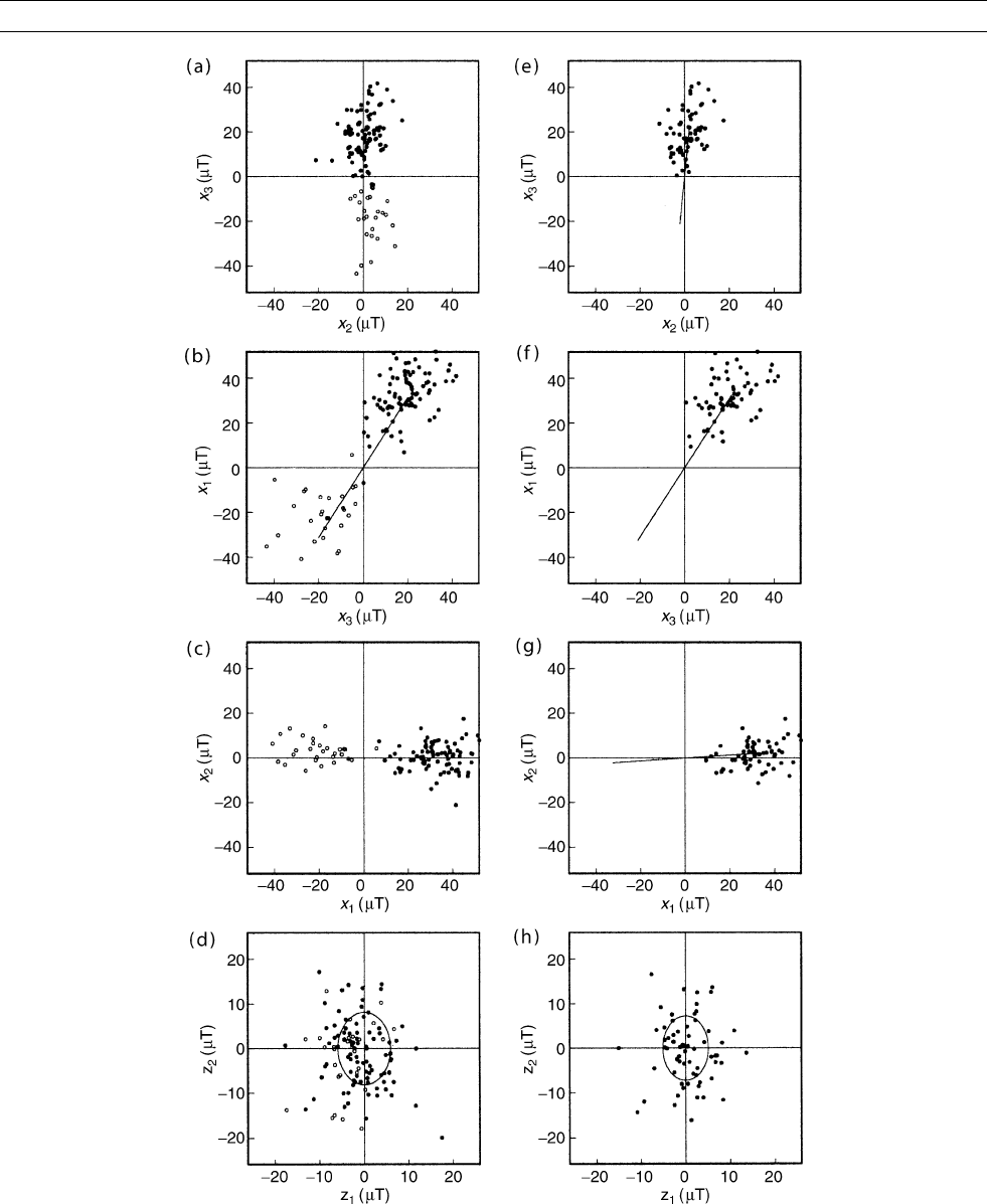
Figure P59 Projection of Hawaiian paleovector data onto the three geographic planes defined by (x
1
,x
2
,x
3
) and onto the eigenplane
z
1
z
2
normal to the direction of the major axis defined by e
3
. (a-d) show data covering the past 5 Ma. (e-f) show data covering the
normal Brunhes. In (a-c) and (e-f) we plot the major axis, and in (d) and (h) we plot the projection of the variance ellipse. Solid circles
(disks) represent normal data, open circles represent reversed data.
PRINCIPAL COMPONENT ANALYSIS IN PALEOMAGNETISM 847
MID ¼
ffiffiffiffiffiffiffiffiffiffiffiffiffiffiffiffiffiffiffiffiffiffiffiffiffiffiffiffiffiffiffiffiffiffiffiffiffiffiffiffiffiffiffiffi
l
1
ðxÞþl
2
ðxÞþl
3
ðxÞ
3
r
; for l
1
’ l
2
’ l
3
:
(Eq. 18)
Otherwise, for aspherical dispersion, we need to consider the projec-
tion of the variance onto e
3
ð0Þ,
MID ¼
ffiffiffiffiffiffiffiffiffiffiffiffiffiffiffiffiffiffiffiffiffiffiffiffiffiffiffiffiffiffiffiffiffiffiffiffiffiffiffiffiffiffiffiffiffiffiffiffi
X
m
l
m
ðxÞ e
m
ðxÞe
3
ð0Þ½
2
r
: (Eq. 19)
Hawaiian bimodal vectors
Let us now illustrate the utility of principal component analysis with
paleomagnetic data. For this example, we consider Hawaiian paleo-
magnetic vector data coming from lava flows emplaced over the past
5 Ma (Love and Constable, 2003), a period of time that encompasses
several periods of normal and reverse field polarity. We consider only
those flows that, upon sampling and subsequent measurement, have
yielded complete triplets of intensity, inclination, and declination
(F(i), I(i), D(i)), and which, therefore, represent the full ambient mag-
netic vector at the time of deposition. Calculating the covariance
matrix about the origin, using r ¼ 0inEq. (3), we perform a principal
component analysis to obtain the eigenvalues and corresponding
eigenvectors; see Table P3. The major axis along e
3
is orientated
almost parallel to the mean direction found by others using other meth-
odologies. This axis is shown in Figure P59a-P59c, where we see that
it passes through both the zero point origin and the cloud of points
defining the paleosecular variation. As a physical interpretation, it is
this axis about which the geomagnetic field varies over time and, even,
occasionally reverses its polarity. In Figure P59d we show the projec-
tion of the data onto the eigenplane z
1
z
2
, where we also plot the
variance ellipse defined by the projection of the variance ellipsoid.
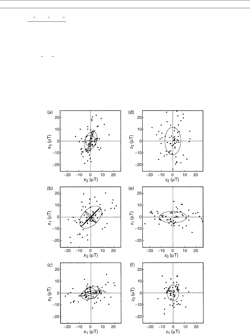
Figure P60 Projection of Brunhes Hawaiian paleovector secular-variation data (with mean vector having been subtracted) onto (a-c) the
three geographic planes defined by (x
1
,x
2
,x
3
) and onto (d-f) the three eigenplanes defined by ðz
1
; z
2
; z
3
Þ. Also shown are the projections
of the three equators of the variance ellipsoid in each coordinate system.
848 PRINCIPAL COMPONENT ANALYSIS IN PALEOMAGNETISM
The slightly asymmetric form of the paleosecular variation about the
major axis is to be noted.
Hawaiian unimodal vectors
Next, let us consider Brunhes normal data from Hawaii. Results of a
principal component analysis of these data for reference point r ¼ 0
are given in Table P3.InFigure P59e-P59g we plot the major axis
defined by e
3
, and in Figure P59h we show the projection of the data
onto the eigenplane z
1
z
2
, along with the corresponding variance
ellipse. The results here are not dramatically different from the pre-
vious result, where we used data of mixed polarities, although some
slight differences in the orientation of the major axis and variance size
are noted. In order to better inspect the nature of the paleosecular var-
iation at Hawaii during the Brunhes, we perform a principal compo-
nent analysis of the covariance about the mean vector r ¼
x.In
Table P3 we see that much of the secular variation is roughly parallel
with the mean vector; the angular difference between the orientation of
the two vectors is only 14.9
. The geometric form of the variance of
the secular variation is shown in Figure P60, where we plot both the
data and the variance ellipse in geographic and eigencoordinates.
The utility of measuring the variance about the vectorial mean r ¼
x
and in the eigenspace z should now be obvious.
Directional analysis
Usually, paleomagnetists do not have complete vectorial data. Instead,
directional data, consisting of inclination and declination values (I(i),
D(i)), are most commonly available. Therefore, let us consider a prin-
cipal component analysis for directional-only data. The equivalent
Cartesian expression of the data is
^
x
1
ðiÞ¼cos IðiÞcos DðiÞ;
^
x
2
ðiÞ¼cos IðiÞsin DðiÞ;
^
x
3
ðiÞ¼sin IðiÞ: (Eq. 20)
With N such directional data we can calculate their covariance about
the defined origin r ¼ð0; 0; 0Þ
^
C ¼
1
N
P
^
x
1
ðiÞ
2
P
^
x
1
ðiÞ
^
x
2
ðiÞ
P
^
x
1
ðiÞ
^
x
3
ðiÞ
P
^
x
2
ðiÞ
^
x
1
ðiÞ
P
^
x
2
ðiÞ
2
P
^
x
2
ðiÞ
^
x
3
ðiÞ
P
^
x
3
ðiÞ
^
x
1
ðiÞ
P
^
x
3
ðiÞ
^
x
2
ðiÞ
P
^
x
3
ðiÞ
2
0
B
B
@
1
C
C
A
:
(Eq. 21)
As before, eigenvalues l
m
and eigenvectors e
m
can be obtained for this
matrix. Because all the data are unit vectors, the total variance mea-
sured relative to the origin is one and the trace of
^
C is unity:
trð
^
CÞ¼1; (Eq. 22)
and so the sum of the three eigenvalues is determined,
l
1
þ l
2
þ l
3
¼ 1: (Eq. 23)
This means that the eigenvalues have only two degrees of freedom.
For a prolate variance ellipsoid, the approximate maximum angular
deviation from the major axis along e
3
is
MAD
p
¼ tan
1
ffiffiffiffiffiffiffiffiffiffiffiffiffi
1 l
3
l
3
s
"#
; (Eq. 24)
and for an oblate variance ellipsoid, the corresponding angular devia-
tion from the plane normal to e
1
is
MAD
o
¼ tan
1
ffiffiffiffiffiffiffiffiffiffiffiffiffi
l
1
1 l
1
s
"#
: (Eq. 25)
Hawaiian bimodal directions
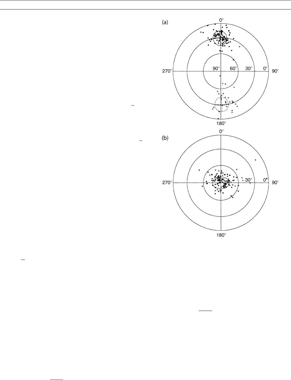
As a final example, we return to the mixed polarity Hawaiian data
covering the past 5 Ma, but this time we only consider the paleodirec-
tions ðIðiÞ; DðiÞÞ. Results of a principal component analysis of the
corresponding unit vectors for reference point r ¼ 0 are given in Table
P3.InFigure P61a we plot the data, and the minor ellipse defined by
l
1
and l
2
, in an equal-area projection of geographic coordinates. After
rotation into eigenspace (Figure P61b), we see, quite clearly, the asym-
metric variance of paleodirections, thus, demonstrating the utility of
inspecting directional data in the eigenspace z.
Jeffrey J. Love
Figure P61 Equal-area projection of Hawaiian directional data,
defined in (a) geographic coordinates and (b) eigen coordinates.
Also shown are the projections of the variance minor ellipse,
defined by l
1
and l
2
. As is conventional, the azimuthal
coordinate is declination (clockwise positive, 0
–360
), and the
radial coordinate is inclination (from 90
in the center to 0
on the
circular edge).
PRINCIPAL COMPONENT ANALYSIS IN PALEOMAGNETISM 849

Bibliography
Hotelling, H., 1933. Analysis of a complex of statistical variables into
principal components. Journal of Educational Psychology, 24:
417–441, 498–520.
Jolliffe, I.T., 2002. Principal Component Analysis, 2nd edn. New
York: Springer-Verlag.
Karhunen, K., 1947. Über lineare Methoden in der Wahrscheinlich-
keitsrechnung. Annales Academiae Scientiarum Fennocaeseries
A1, 37:3–79.
Kirschvink, J.L., 1980. The least-squares line and plane and the analy-
sis of palaeomagnetic data. Geophysical Journal International, 62:
699–718.
Loéve, M., 1977. Probability Theory, 4th edn. New York: Springer-
Verlag.
Love, J.J. and Constable, C.G., 2003. Gaussian statistics for pa-
laeomagnetic vectors. Geophysical Journal International, 152:
515–565.
Mardia, K.V., 1972. Statistics of Directional Data. New York: Aca-
demic Press.
Pearson, K., 1901. On lines and planes of closest fit to systems of
point in space. Philosophical Magazine, series 6, 2: 559–572.
Schomaker, V., Wasser, J., Marsh, R.E. and Bergman, G., 1959. To fit
a plane or a line to a set of points by least squares. Acta crystallo-
graphica, 12: 600–604.
Strang, G., 1980. Linear Algebra and Its Applications, New York:
Academic Press.
Cross-references
Bingham Statistics
Fisher Statistics
Magnetic Remanence, Anisotropy
Paleomagnetic Secular Variation
Statistical Methods for Paleovector Analysis
PROJECT MAGNET
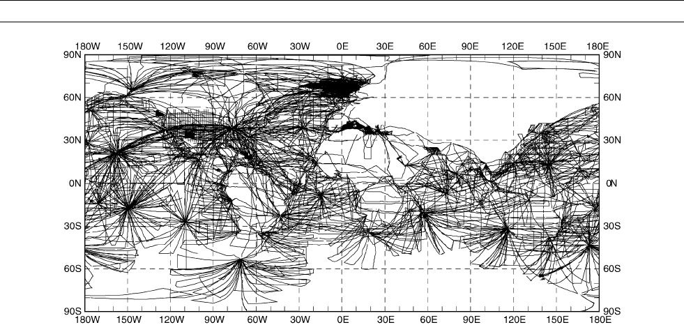
Project Magnet is a comprehensive vector aeromagnetic surveying
enterprise that spanned much of the last five decades. Under the direc-
tion of the United States Navy and management by the Naval Oceano-
graphic Office, test flights began in 1951 and full operational
capabilities were established in 1953. The project ran through 1994, ulti-
mately contributing many thousands of track miles (see Figure P62)of
geomagnetic data (Coleman, 1992). The data are available on CD-ROM
through the National Geophysical Data Center (Hittelman et al., 1996).
The primary purpose of Project Magnet was to supply data in support
of the World Magnetic Modeling (WMM) and charting program, which
in turn supported civilian and military navigation requirements. The
WMM has been incorporated into many global positioning system
(GPS) receivers manufactured in the United States and has been used
to control drift rates in inertial navigation systems. As a geophysical tool,
the WMM has been useful as a reference measurement for Earth’s core–
mantle boundary field and as an aid in geophysical prospecting and
resource evaluation.
Over the years, Project Magnet surveys have been performed using
five different aircrafts, with each successive one improving in range,
speed or altitude, navigational capabilities, and geophysical instrumen-
tation. From 1953 to 1970 survey aircraft flew at 4615 m and most
surveys were confined to remote ocean areas. Navigation methods in
use at the time were periodic celestial fixes, LORAN, and dead reck-
oning. As a result, navigational accuracy was rather poor and was lim-
ited to about 5 nautical miles. Altitudes were determined using a
baroclinic altimeter, with an uncertainty of 30 m. Observations of
declination, inclination, and intensity (to an accuracy of 15 nT)
were made using a self-orienting fluxgate magnetometer, while a
towed, optically pumped metastable helium magnetometer measured
field intensity to 4 nT. Until 1970, data acquisition systems
consisted primarily of strip chart recorders and navigation logs. The
majority of this data has been manually digitized.
The introduction of a new aircraft in 1970 permitted high level (over
4615 m) vector aeromagnetic surveying, usually conducted at altitudes
between 6200 and 7700 m. During this era, the use of inertial naviga-
tion systems improved navigational accuracy to about 1 nautical mile,
and in 1987, after the appearance of GPS, accuracies were further
increased to several tens of meters, but only when a reliable signal
was available. A baroclinic altimeter similar to the previous one was
again the only source of altitude data. Improved magnetic measurements
were facilitated by a fluxgate magnetometer, providing three vector
components X, Y, and Z in the local reference frame to accuracies of
40 nT. An optically pumped metastable helium magnetometer
mounted on a stinger extending from the rear of the aircraft measured
intensity to 1 nT.
Major technological improvements arrived with the 1990s and by
1992 the Project Magnet aircraft had been fitted with an ASG-81 sca-
lar magnetometer, a NAROD ring-core fluxgate vector magnetometer,
and a ring-laser gyro (RLG) inertial system. The latter two instruments
were mounted on a rigid beam in a magnetically clean area at the rear
of the aircraft. The RLG was used primarily for attitude determination,
while GPS, a radar system and a precision barometer were employed
for altitude measurements, which were determined to a precision of
less than 2 m. The GPS system was the primary navigational tool, with
a circular error probability of 15 m. However, the accuracy of the mag-
netic measurements remained the same. Technological advancements
also led to the incorporation of a number of other surveying capabil-
ities, including gravity, ocean acoustics, and ocean temperature.
Survey data were calibrated by several low level “airswings” prior
to and during the high level surveying. The airswings included straight
and level passes as well as roll, pitch and yaw maneuvers in each car-
dinal direction at 1000 feet over a groun d based observatory. The cali-
bration data were used to model aircraft intrinsic magnetic fields that
perturb the magnetometer data. The contaminating fields are due to:
the permanently magnetized part of the aircraft; magnetization induced
by the core field; and eddy currents driven by changes in the crustal
and core fields as the aircraft passed through them. A compensation
model, based on developments by Leliak (1961), involves a two-step
iterative least squares solution for 21 coefficients, which characterize
the contaminating fields, and three bias angles, which account for dif-
ferences in the orientations of the vector magnetometer and the inertial
navigation system. Measurements taken over all airswing maneuvers
are then included in a least squares minimization of the difference
between the magnitudes of the decontaminated aeromagnetic observa-
tions and the transformed ground based observations. This transforma-
tion involves upward continuation to aircraft altitude and rotation into
the aircraft reference frame using roll, pitch and heading data.
The compensation model is imprecise in that it is based on the
assumption that the coefficients are constant with respect to latitude
and frequency of the airswing maneuvers. There have been attempts
to account for these variations and the Project Magnet database
includes compensation coefficients from repeated calibration flights
at observatories over the globe. More importantly, Project Magnet
orientation accuracy is insufficient to prevent contamination of the
magnetic field vector components due to misalignment of the aircraft
coordinate system (Parker and O’Brien, 1997). Because field intensity
is immune from orientation errors, Parker and O’Brien (1997) show
that simple spectral analysis of intensity and the three vector magnetic
components as functions of along track distance may be used as a
diagnostic for this contamination.
Although one of the primary goals of Project Magnet was to charac-
terize the magnetic field generated in Earth’s core, the majority of
published studies exploiting Project Magnet data have been focused
on the crustal part of the field, including numerous regional magnetic
850 PROJECT MAGNET
mapping efforts spread across the globe. These include sub-Saharan
Africa (Green, 1976), South Georgia Island (Simpson and Griffiths,
1982), Iceland (Jonsson et al., 1991), and New Zealand (McKnight,
1996). A detailed study by Horner-Johnson and Gordon (2003) of short
wavelength features (20–150 km) over the equatorial Pacific, suggests
that magnetic anomalies associated with seafloor spreading are more
clearly delineated by vector aeromagnetic data than by the traditional
shipboard total field observations. O’Brien et al. (1999) developed a
method, based on spectral analysis of Project Magnet data along great
circle paths, to estimate the geomagnetic spatial spectrum of the oceanic
crust for spherical harmonic degrees from l 60 to 1200. Observational
models based on satellite data had previously been limited to l 100.
Korte et al. (2002) observed that the agreement of the new model with
satellite based observations was unsatisfactory for degrees l < 100,
and found that O’Brien et al. had overcompensated for external magnetic
field variations in their analysis. The improved model of Korte et al.
(2002) achieves better agreement with theoretical and satellite based
models of the spatial spectrum.
The advent of satellite based magnetic observations, in particular
Magsat in the 1980s raised the question of agreement between aero-
magnetic and spaced based geomagnetic observations. An early study
by Won and Son (1982), using Project Magnet data spanning the con-
tinental US and upward continued to Magsat altitude, revealed agree-
ment in gross features of the crustal field. Using an improved
method for removing the core field (spherical harmonic degrees
l 13) and long wavelength external contributions, Wang et al.
(2000) demonstrated excellent agreement between aeromagnetic and
satellite data over the continental US, and suggest that an anomaly
field derived from a combined dataset provides accurate estimates of
the long wavelength crustal field.
David G. McMillan
Bibliography
Coleman, R.J., 1992. Project magnet high-level vector survey data
reduction. In Langel, R.A., and Baldwin, R.T. (eds.), Types and
Characteristics of Data for Geomagnetic Field Modelling. NASA
Conference Publication 3153, pp. 215–248.
Green, A.G., 1976. Interpretation of project magnet aeromagnetic pro-
files across Africa. The Geophysical Journal of the Royal Astro-
nomical Society, 44: 203–228.
Hittelman, A.M., Buhmann, R.W., and Racey, S.W., 1996. Project
Magnet Data (1953–1994) CD-ROM User’s Manual. Boulder:
National Geophysical Data Center.
Horner-Johnson, B.C., and Gordon, R.G., 2003. Equatorial pacific
magnetic anomalies identified from vector aeromagnetic data. Geo-
physical Journal International, 155: 547–556.
Jonsson, G., Kristjansson, L., and Sverrisson, M., 1991. Magnetic sur-
veys of Iceland. Tectonophysics, 189: 229–247.
Korte, M., Constable, C.G., and Parker, R.L., 2002. Revised magnetic
power spectrum of the Oceanic crust. Journal of Geophysical
Research, 107, EPM 6.
Leliak, P., 1961. Identification of magnetic field sources of magnetic
airborne detector equipped aircraft. IRE Transactions on Aerospace
and Navigational Electronics, 8:95–105.
McKnight, J.D., 1996. An updated regional geomagnetic field model
for New Zealand. Institute of Geological and Nuclear Sciences
Science Report: Report 96/4; M24/773; M24/774.
O’Brien, M.S., Parker, R.L, and Constable, C.G., 1999. Magnetic
power spectrum of the Ocean crust on large scales. Journal of Geo-
physical Research, 104: 29189–29201.
Parker, R.L., and O’Brien, M.S., 1997. Spectral analysis of vector mag-
netic profiles. Journal of Geophysical Research, 100: 20111–20136.
Simpson, P., and Griffiths, D.H., 1982. The structure of the South Geor-
gia Continental block. In Craddock, C. (ed.) Antarctic Geoscience.
Madison, WI: University of Wisconsin Press, pp. 185–191.
Wang, B., Ravat, D., Sabaka, T., and Hildenbrand, T.G., 2000. Long-
wavelength magnetic field for the conterminous US. from project
magnet and magsat data. Eos,Transactions of the American
Geophysical Union, 81, GP71B-09.
Won, I.J., and Son, K.H., 1982. A preliminary comparison of the
MAGSAT data and aeromagnetic data in the Continental US.
Geophysical Research Letters, 9: 296
–298.
Cross-references
Aeromagnetic Surveying
Core-mantle Boundary
Electromagnetic Induction (EM)
Geomagnetic Spectrum, Spatial
Instrumentation, History of
Magsat
Upward and Downward Continuation
Figure P62 Coverage of Project Magnet aeromagnetic surveys, 1953–1994 (cylindrical equidistant projection). Reproduced by
permission of the National Geophysical Data Center.
PROJECT MAGNET 851

PROUDMAN-TAYLOR THEOREM
Geophysicists accept a suggestion traceable back to a paper by Elsasser
(1939) that the near-alignment of the main geomagnetic field (see
Main field) with the Earth’s geographic polar axis is a manifestation
of the influence on convective motions in the liquid, metallic outer
core (q.v.) that is exerted by gyroscopic (Coriolis) forces associated
with the Earth’s diurnal rotation. Such forces render core motions ani-
sotropic and highly sensitive to the mechanical and other (thermal and
electromagnetic) boundary conditions imposed on the motions by the
underlying solid inner core (q.v.) and the overlying mantle (q.v.) (for
further references see Hide, 2000).
The influence of Coriolis forces on motions in spinning fluids is
most pronounced in mechanically-driven flows satisfying the so-called
Proudman-Taylor (PT) theorem. Stated in words, the theorem (see
Eq. (5)) shows that “slow and steady hydrodynamical motion of an
inviscid (and electrically insulating) fluid of constant density that is
otherwise in steady “rigid-body” rotation will be the same in all planes
perpendicular to the axis of rotation”. Given in a paper by J. Proudman
in 1916, the PT theorem was successfully tested by means of a labora-
tory experiment in which G.I. Taylor investigated the relative flow
produced in a tank of water in rapid rotation about a vertical axis by
the slow and steady horizontal motion of a solid body through the
water (see Greenspan, 1968). In accordance with the theorem, the flow
was highly two-dimensional nearly everywhere and the moving solid
object carried with it a “Taylor column” of water extending axially
throughout the whole depth of the tank.
We note here in passing (a) that the theorem had appeared much ear-
lier in the literature, in a paper on tidal theory by S.S. Hough (Gill,
1982), and (b) that some writers find it convenient to refer to it as
the “Proudman theorem” (Hide, 1977), to avoid confusion with another
theorem, due to G.I. Taylor, concerning effects of Coriolis forces on
fluid motions (see Greenspan, 1968; Hide, 1997).
Convective motions in the core (q.v.) cannot satisfy the PT theorem
exactly because they are driven by buoyancy forces due to the action
of gravity on density inhomogeneities, which give rise to axial varia-
tions of the horizontal components of the relative flow velocity (see
Eq. (6)). Core motions are also influenced by Lorentz forces associated
with electric currents and magnetic fields in the core, which in regions
well below the core-mantle boundary (q.v.) may be comparable in
strength with Coriolis forces (see Eqs. (1) and (2)). But—as in theore-
tical work in dynamical meteorology and oceanography, see e.g., Gill,
1982; Pedlosky, 1987—certain basic dynamical processes and pheno-
mena can be elucidated by means of simplified theoretical models in
which axial variations of the nonaxial components of the relative flow
velocity are neglected in the first instance.
Characteristic shear waves that occur in fluids subject to Coriolis and/or
Lorentz forces—such as Rossby waves, Alfvén (magnetohydrodynamic
waves (q.v.)) and related hybrid waves (one important type of which
may underlie the geomagnetic secular variation (q.v.))—have been
investigated in this way. And so have other phenomena, such as torsional
oscillations of the core-mantle system associated with angular momen-
tum transfer within the Earth’s core (Hide
et al., 2000) and differential
rotation produced in a rapidly rotating spherical fluid annulus by
potential vorticity (q.v.) mixing (Hide and James, 1983).
Geostrophic and magnetostrophic flows
Flows satisfying the PT theorem belong to a wider class of “geos-
trophic” flows (see Gill, 1982; Pedlosky, 1987), for which the horizontal
component of the local pressure gradient, grad p, is closely balanced by
the horizontal component of the Coriolis force (per unit volume),
2rVxu (see Eq. (1)), but torques produced by buoyancy forces asso-
ciated with horizontal density gradients give rise to systematic axial var-
iations in the horizontal components of u (see Eqs. (5) and (6)).
Consider a moving element of fluid of density r which at time
t is located at a general point P with vector position r in a frame of
reference that rotates with angular velocity V relative to an inertial
frame. Newton’s second law is conveniently expressed as follows (see
Hide, 1971):
2rVxu þ grad p þ r grad V þA ¼ 0(Eq.1)
where the Eulerian flow velocity at P and the corresponding pressure
and the potential due to gravitational plus centripetal effects are
denoted by u, p, and V respectively. The “ageostrophic” term, A,in
Eq. (1) is defined as follows:
A ¼ r½]u=]t þðu:gradÞu rxdV=dt þcurl ðnrv
Þ jxB
(Eq. 2)
if v ¼ curl u, the relative vorticity vector at P, and n denotes the coef-
ficient of kinematic viscosity. The term jxB in Eq. (2) is needed when
dealing with electrically conducting fluids; it represents the Lorentz
force per unit volume acting on the fluid element if j is the electric cur-
rent density and B the magnetic field at P.
The flow is said to be geostrophic in regions where A is negligible
in comparison with other terms in Eq. (1). Within the Earth’s core
(q.v.), such regions probably arise in its upper reaches (LeMouël,
1984; Hide, 1995) where the toroidal part of the geomagnetic field
(q.v.) is no stronger than the poloidal part and the corresponding Lorentz
term is typically no more than a few parts percent of the Coriolis term
in magnitude. On the other hand, the flow is said to be in “magnetos-
trophic” (rather than geostrophic) balance in any regions where the
Lorentz force provides the main contribution to A and is comparable
in magnitude with 2rVxu. Such regions probably arise at depth within
the core, where the toroidal part of the magnetic field may be an order
of magnitude stronger than the poloidal part.
Following Hide, 1971, now consider the balance of torques acting
on the moving fluid element by taking the curl of Eq. (1), thereby
obtaining the so-called “vorticity” equation in the useful form
2V:grad ðruÞþgrad V x grad r þ curl A þ 2VC ¼ 0:
(Eq. 3)
Here C ¼ @
r/@t which, by the mass continuity equation, satisfies
div ðruÞþC ¼ 0: (Eq. 4)
The PT theorem follows immediately from Eq. (3), for when the con-
ditions A ¼ 0, grad r ¼ 0 and C ¼ 0 are satisfied, the equation
reduces to
ð2V:gradÞ u ¼ 0: (Eq. 5)
The above equation implies that all three components of u are inde-
pendent of the axial coordinate. When the restriction to cases of fluids
of constant density is relaxed we have
2V:grad ðruÞþgrad V x grad r ¼ 0; (Eq. 6)
in place of Eq. (5).
Flow patterns satisfying Eqs. (5) or (6) are constrained by Coriolis
forces to have no circulation in (meridian) planes containing the axis
of rotation. But by Eq. (6) the horizontal component of u is not inde-
pendent of the axial direction, except in regions where grad r has no
horizontal component. We note here in passing (a) that the specific
helicity, u.v,—a quantity of importance in dynamo theory (q.v.)—of
flows satisfying Eq. (6) is generally nonzero (Hide, 1976), and (b) that
with certain geometrical simplifications Eq. (6) leads to the meteor-
ologist
’s “thermal wind” equation (q.v.) relating the rate of increase
852 PROUDMAN-TAYLOR THEOREM

of the speed and direction of the geostrophic wind with height in the
atmosphere to the horizontal gradient of temperature.
Ageostrophic effects and detached shear layers
The full expression of the laws of mechanics given by Eq. (1) is, of
course, prognostic, in the sense that when solved simultaneously with
the full equations of thermodynamics and electrodynamics under all the
relevant boundary conditions the equation gives the fields of all the
dependent variables, p, u, r, j, B etc. But the expression for geostrophic
flow to which Eq. (1) reduces in regions where the ageostrophic term,
A, is negligible is diagnostic (rather than prognostic), in the sense that it
provides useful relationships between u, p and r, but it cannot give full
solutions satisfying all the relevant boundary conditions.
It follows that flows in real systems cannot be geostrophic every-
where. Regions of ageostrophic flow involving length scales so short
that A is comparable in magnitude with 2rVxu must be present not
only on bounding surfaces (in Ekman-Hartmann and Stewartson
boundary layers (see core, boundary layers)) but also within the main
body of the fluid, in “detached shear layers”. It is within such regions,
where effects due to Coriolis forces are countered by strong ageos-
trophic effects, that meridional circulation can occur. Detached shear
layers formed the “walls” of the so-called “Taylor column” of fluid that
remained attached to the moving solid body in G. I. Taylor’s experi-
ment. Geophysical examples of ageostrophic detached shear layers
embedded in geostrophic flows are the jet streams and their associated
frontal systems seen in the Earth ’s atmosphere and “western boundary”
currents such as the Gulf Stream in the Atlantic Ocean and the Kuroshio
Current in the Pacific Ocean (see Gill, 1982; Pedlosky, 1987).
Amongst the various laboratory investigations that were stimulated
directly by the original “Taylor column” experiment were several stu-
dies of the effect of the inner spherical boundary on patterns of mechani-
cally-driven (Greenspan, 1968; Hide, 1977) and buoyancy-driven flows
in a rotating spherical annulus of fluid. These studies clearly demon-
strated what general arguments based on Eq. (5) or (6) predict, namely
that near the imaginary “tangent cylindrical surface” (see Inner core tan-
gent cylinder) in contact with the equator of the inner spherical surface
and extending axially throughout the fluid, a detached shear layer would
form inhibiting mixing of fluid in the “polar” regions inside the cylinder
with fluid in the “equatorial” region outside the cylinder. Such beha-
viour is thought to bear on core dynamics and the influence of the solid
inner core on structure of the geomagnetic field (for further references
see Hide, 2000 and Hide, 1966a,b).
Raymond Hide
Bibliography
Elsasser, W.M., 1939. On the origin of the Earth’s magnetic field.
Physical Reviews, 55: 489–497.
Gill, A.E., 1982. Atmosphere-Ocean Dynamics. New York: Academic
Press.
Greenspan, H.P., 1968. The Theory of Rotating Fluids. Cambridge:
Cambridge University Press.
Hide, R., 1966a. The dynamics of rotating fluids and related topics in
geophysical fluid dynamics. Bulletin of the American Meteorologi-
cal Society, 47: 873–885.
Hide, R., 1966b. Free hydromagnetic oscillations of the Earth’s core
and the theory of the geomagnetic secular variation. Philosophical
Transactions of the Royal Society of London, A259: 615–647.
Hide, R., 1971. On geostrophic motion of a nonhomogeneous fluid.
Journal of Fluid Mechanics, 49: 745–751.
Hide, R., 1976. A note on helicity. Geophysical (Astrophysical) Fluid
Dynamics, 7: 157–161.
Hide, R., 1977. Experiments with rotating fluids; Presidential address.
Quarterly Journal of the Royal Meteorological Society, 103:1–28.
Hide, R., 1995. The topographic torque on the rigid bounding surface
of a rotating gravitating fluid and the excitation of decadal fluctua-
tions in the Earth’s rotation. Geophysical Research Letters, 22:
1057–1059.
Hide, R., 1997. On the effects of rotation on fluid motions in contain-
ers of various shapes and topological characteristics. Dynamics of
Atmospheres and Oceans, 27: 243–256.
Hide, R., 2000. Generic nonlinear processes in self-exciting dynamos
and the long-term behaviour of the main geomagnetic field, includ-
ing superchrons. Philosophical Transactions of the Royal Society
of London, A358: 943–955.
Hide, R., Boggs, D.H., and Dickey, J.O., 2000. Angular momentum
fluctuations within the Earth’s core and torsional oscillations of
the core-mantle system. Geophysical Journal International, 143:
777–
786.
Hide, R., and James, I.N., 1983. Differential rotation produced by
large-scale potential vorticity mixing in a rapidly-rotating fluid. Geo-
physical Journal of the Royal Astronomical Society, 74:301–312.
Le Mouël, J.-L., 1984. Outer core geostrophic flow and the secular
variation of the Earth’s magnetic field. Nature, 311: 734–735.
Pedlosky, J., 1987. Geophysical Fluid Dynamics, 2nd edn. New York:
Springer-Verlag.
Cross-references
Core, Boundary Layers
Core Convection
Core-Mantle Boundary
Core Motions
Equilibration of Magnetic Field, Weak and Strong Field Dynamos
Geodynamo
Geomagnetic Secular Variation
Inner Core Tangent Cylinder
Length of the Day Variations, Decadal
Magnetohydrodynamic Waves
Oscillations, Torsional
Potential Vorticity and Potential Magnetic Field Theorems
Thermal Wind
PROUDMAN-TAYLOR THEOREM 853

R
RADIOACTIVE ISOTOPES, THEIR DECAY IN
MANTLE AND CORE
Intro ductio n
The Earth is a thermal engine driven largely by heat produced from the
decay of naturally occurring radioactive isotopes in its interior. At pre-
sent, the main radioactive isotopes are
40
K,
235
U,
238
U, and
232
Th, whose
atomic percentages, radioactive decay constants, half-life, and the heat
production characteristics are given in Table R1.
26
Al, an extinct radio-
active isotope may have been an important heat source in the early
history of the Earth. Many other radioactive isotopes are also present
in the Earth but they play a negligible role in heat production, either
because of their low abundance or their low heat producing capacity.
The abundances of K, U, and Th in common rocks from the crust
and some upper mantle materials are available from direct measure-
ments. The compilation by Van Schmus (1995) lists their abundances
and also shows some primitive mantle (present mantle þ crust) esti-
mates. Since then, new estimates of these elements in the primitive
mantle (bulk silicate Earth —BSE) and the Earth have appeared, as
also new experimental and theoretical studies bearing on radioactivity
in the core.
Radioact ivity of the mant le
Direct measurements of the radioactivity of rocks from the mantle are
limited to its outermost layers just a few hundred kilometers deep in
the upper mantle. Much of the lower mantle is not accessible for direct
measurements and geophysical parameters such as seismic velocities
and mineral physics data cannot provide strong constraints to its com-
position (Mattern et al., 2005). Current estimates of the abundances of
K, U, and Th in BSE, and the Earth as a whole, are derived from
several geochemical models. These combine cosmochemical considera-
tions and composition of meteorites with some coherent trace element
ratios observed in upper mantle samples and meteorites. The composi-
tion of volatile-rich C1 carbonaceous chondrites (a primitive class of
meteorites with elemental abundances that closely match the compo-
sition of the solar photosphere) is used as a reference to compare the
terrestrial abundances and deduce chemi cal fractionation patterns in
the Earth (C1 models). The most comprehensive modeling of this type
by McDonough and Sun (1995) provides a complete description of the
methods and references to prior work. The abundance data of K, U,
and Th in the primitive mantle from some of these studies (Table R2)
are now included in the GERM database (GERM-A Geochemical Earth
Reference Model at http://earthref.org/GERM/index.html). Implicit in
these models is the assumption that the lower mantle is compositionally
similar to the upper mantle and that the Fe-metallic core of the Earth has
no radioactivity. Whether or not the mantle is compositionally layered
is still unresolved (see for example, Anderson, 1989a,b). The K/U ratio
in rocks from the crust and upper mantle is 110
4
but in chondrite
meteorites is 810
4
(see Lassiter, 2004 for an up-to-date discussion
of K/U ratios in terrestrial materials and meteorites). In the geochemical
models, the low K/U ratio in the Earth, and the estimated low K
abundance in the Earth relative to meteorites is attributed to the loss of
moderately volatile K from the Earth.
Some recent experiments have raised questions about the C1-chondrite
comparisons and the postulated loss due to volatility. Oxygen, the most
abundant major element in the Earth (>30% by mass) has a different iso-
topic composition from that in carbonaceous and ordinary chondrites
(Clayton, 1993) casting doubt on their suitability for the precursor Earth
material. The identical K isotopic composition of terrestrial and meteori-
tic material indicates that the loss of K could not be due to partial vapor-
ization from the Earth but must have preceded the process of planetary
formation (Humayun and Clayton, 1995). Furthermore, C1 meteorites
cannot provide for the 30% Fe abundance in the Earth (Javoy, 1995).
Table R1 Important heat producing radioactive isotopes in the Earth: their decay constants, half-lives and heat production values
(Van Schmus, 1995)
Isotope Atomic percentage Decay constant, l (yr
1
) Half-life (yr) Specific isotopic heat production (mWkg
1
)
40
K 0.01167 5.54 10
10
1.25110
9
29.17
235
U 0.7200 9.85 10
10
7.03810
8
568.7
238
U 99.2743 1.55110
10
4.46810
9
94.65
232
Th 100.00 4.95 10
11
1.40110
10
26.38

Drake and Righter (2002) have discussed the general difficulty of using
chondritic meteorites for the initial starting composition of the Earth.
Given these considerations, and the debate about whether the mantle is
compositionally layered, the geochemical estimates of K, U, and Th in
Table R2 seem not well constrained.
Geophysical models use terrestrial heat-flow data or other aspects of
geodynamics and plate tectonics to constrain the radioactivity of the
mantle. Global average heat-flow estimates range from 30 to 44TW
(TW ¼ 10
12
W). The higher value (Pollack et al., 1993; Stein, 1995)
is greater than twice the radiogenic heat production of various C1
models (see compilation by Lodders and Fegley, 1998). Even at the
recently suggested heat flux of 31 1TW (Hofmeister and Criss,
2005), the C1 models fall short by about 10–12TW. This short-fall
may be satisfied by considering a significant secular cooling delay of
>1–2Ga (Ga ¼ 10
9
years) where the surface heat flux represents
radiogenic heat produced in the past, or by including residual primor-
dial heat from the time of accretion. Definitive conclusions about
either of these possibilities cannot be reached at present. Alternatively,
additional radioactive heat sources in the interior can also meet the
global surface heat flux requirement.
The only meteorite materials with O-isotopic composition similar to
the Earth (and the Moon) are the enstatite chondrites (EH, EL) and the
enstatite achondrites (aubrites). Models of the Earth with EH chon-
drites as precursor materials have been considered in some recent stu-
dies (Javoy, 1995; Lodders, 1995, 2000; Hofmeister and Criss, 2005).
These models have the advantage of simultaneously satisfying the
stringent requirement of the O-isotopic composition, the high iron con-
tent of the Earth, and the global heat-flow data. Models of this type
result in a BSE with higher radioactive contents than those listed
in Table R2. For example, Hofmeister and Criss (2005) find that suit-
able BSE compositions that satisfy the surface heat flux of 31TW can
be represented by compositions or mixtures with EH meteorites as
one end member. If the terrestrial K/U of 10
4
is a constraint, for no
secular cooling delay or delay of <1Ga, a BSE composition with
300–350ppmK, about 30–35ppbU, and 110–130ppbTh is required.
Higher heat fluxes lead to even higherK, U, and Th contents. Using essen-
tially EH chondrites as precursor materials, Lodders (1995) estimated the
model BSE to contain over 1000ppmK. It thus appears that estimates of
the radioactivity of the silicate portion on the Earth (68% by mass of
the planet) cannot be uniquely constrained at present; rather, we have
some model-dependent estimates that need further evaluation.
Radioactivity of the co re
Radioactivity in the core has been a controversial topic for a long time.
The traditional view is that there is no radioactivity in the core (see for
example, McDonough, 1999). In contrast, some recent developments
in experiments and theory suggest the possible presence of radioactiv-
ity in the core. Of the radioactive elements discussed here, K is the
only element for which there is some basis both in theory and experi-
ment (Murthy et al., 2003; Lee et al., 2004 and the references cited in
the papers). Table R3 summarizes the theoretical and experimental
estimates of K from these studies and the corresponding radiogenic
heat production in the core. U and Th have been hypothesized to be
in the core (Herndon, 1980), but the experimental investigations so
far are inconclusive or contradictory.
The estimated core-mantle boundary (CMB) heat flux ranges from
2 to 12TW (Labrosse and Macouin, 2003 and references cited therein).
The CMB heat flux controls the rate of core cooling. Nimmo et al.
(2004) have studied the question of how best to reconcile the CMB
heat flux with the small size of inner core together and the >3.5Ga
age of the magnetic field. These authors note that the presence of K
in the core at about 400ppm is in best accord with the present size
of the inner core and the power needs of a geomagnetic dynamo for
the past 3.5Ga. Using somewhat different parameters, similar conclu-
sions have been reached by others (Labrosse, 2003 and the references
cited therein). Purely thermal models of the core call for an additional
heat source in the core and in view of the recent experimental data, it is
reasonable to attribute this to the radioactivity of K in the core.
Table R3 Estimates of potassium abundance in the core from geochemical models, theoretical calculations, and recent experiments
and the corresponding heat production in terawatts (TW) today
Method Abundance (ppm) Radiogenic heat
production (TW)
References
Geochemical models 0 0 McDonough and Sun (1995), McDonough (1999),
and GERM database
Theoretical 550260 4–5 Lodders (1995)
a
200–400 Buffett (2003)
250–750 Labrosse (2003)
Up to 1420 9 Roberts et al. (2003)
b
400 3 Nimmo et al. (2004)
Experimental <1 0.01 Chabot and Drake (1999)
100–250 0.8–2.0 Gessman and Wood (2002)
60–130 0.4–0.8 Murthy et al. (2003)
Up to 7000 Up to 45 Lee and Jeanloz (2003)
c
35 0.23 Hirao et al. (2005)
The GERM database values are shown for comparison.
a
With chondritic U and Th.
b
As quoted in Labrosse and Macouin (2003).
c
See discussion in Lee and Jeanloz (2003). This is an upper limit; for realistic conditions of core formation in the Earth, the authors note that the value is likely to be much less.
Table R2 Some geochemical estimates of K, U, and Th in Earth’s
primitive mantle (mantle plus crust or bulk silicate Earth (BSE))
K U Th References
231 0.021 – Wanke et al. (1984)
180 0.018 0.064 Taylor and McClennan (1985)
266 0.0208 – Hart and Zindler (1986)
258 0.0203 0.0813 Hofmann (1988)
240 0.0203 0.0795 McDonough and Sun (1995)
235 0.0202 0.0764 Van Schmus (1995)
a
All values are in parts per million.
a
Suggested average values.
RADIOACTIVE ISOTOPES, THEIR DECAY IN MANTLE AND CORE 855