Gubbins D., Herrero-Bervera E. Encyclopedia of Geomagnetism and Paleomagnetism
Подождите немного. Документ загружается.


s
ff
w ¼ 0
¼ s
3
: (Eq. 45)
In the ionosphere, s
0
800s
1
, and this tends to keep the conductivity
s
ff
much smaller than the Cowling conductivity s
3
in all regions
except those where the magnetic dip is small. In a narrow band along
the dip equator, corresponding to the equatorial electrojet, s
ff
is
approximately equal to the Cowling conductivity.
Disturbance daily variation
The disturbance daily variation is simply the daily variation that occurs
when the Earth rotates about the geographic axis when it is surrounded
by a ring current system symmetric about the geomagnetic axis.
Annual variation
Walker, in his Adam’s Prize essay of 1866 (Walker, 1866) includes a
chapter on the annual variation, recording that Cassini noted an annual
variation in the direction of the compass needle in 1786. Modern ana-
lyses show that there are both annual and semiannual components.
Spherical harmonic analysis shows that the annual term is dominantly
a zonal quadrupolar term, and the semiannual term is a zonal dipolar
term. Determination of these long period terms is difficult due to alias-
ing by shorter period variations. For example, a calculation based on
midnight values only will detect the K1 tide, a sidereal time variation,
as an annual term. The precise origin of these terms is still debated,
but annual changes in the Sun-Earth geometry have been proposed,
together with the corresponding changes in the influences of the solar
wind on the Earth’s magnetosphere and ring current.
Denis Winch
Bibliography
Baker, W.G., and Martyn, D.F., 1953. Electric currents in the iono-
sphere. I. The conductivity. Philosophical Transactions of the
Royal Society of London, 246A: 281–294.
Bartels, J., 1957. Geizeitenkräfte. Handbuch der Physik, 48: 734–774.
Chapman, S., 1919. The solar and lunar diurnal variations of terrestrial
magnetism. Philosophical Transactions of the Royal Society of
London, 218A: 1–118.
Chapman, S., and Bartels, J., 1940. Geomagnetism. Oxford: Clarendon
Press.
Chapman, S., 1951. The equatorial electrojet as detected from the
abnormal electric current distribution above Huancayo, Peru and
elsewhere. Archiv für Meteorologie Geophysik und Bioklimatolo-
gie, Serie A, Meteorologie und Geophysik, 4: 368–390.
Chapman, S., and Miller, J.C.P., 1940. The statistical determination of
lunar daily variations in geomagnetic and meteorological elements.
Monthly Notices of the Royal Astronomical Society, Geophysical
Supplement, 4: 649–659.
Goertzel, G., 1958. An algorithm for the evaluation of finite trigono-
metric series. American Mathematical Monthly, 65(1): 34–35.
Longuet-Higgins, M.S., 1968. The eigenfunctions of Laplace’s tidal
equations over a sphere. Philosophical Transactions of the Royal
Society of London. 262A: 511–607.
Malin, S.R.C., 1970. Separation of lunar daily geomagnetic variations
into parts of ionospheric and oceanic origin. Geophysical Journal
of the Royal Astronomical Society, 21: 447–455.
Maxwell, J.C., 1873. A Treatise on Electricity and Magnetism. Oxford:
Clarendon Press.
Schuster, A., 1889. The diurnal variation of terrestrial magnetism.
Philosophical Transactions of the Royal Society of London,
180A: 467–518.
Schuster, A., 1908. The diurnal variation of terrestrial magnetism.
Philosophical Transactions of the Royal Society of London,
208A: 163–204.
Stewart, B., 1883. Terrestrial magnetism. The Encyclopædia Britan-
nica, 9th ed, pp. 159–184.
Tarpley, J.D., 1970. The ionospheric wind dynamo–
1. Lunar Tide.
Planetary and Space Science, 18: 2075–1090.
Taylor, G.I., 1936. The oscillations of the atmosphere. Proceedings of
the Royal Society of London, 156A: 318–326.
Walker, E., 1866. Terrestrial and cosmical magnetism. The Adams
prize essay for 1865. Cambridge: Deighton, Bell and Co.
Winch, D.E., 1981. Spherical harmonic analysis of geomagnetic tides,
1964–1965. Philosophical Transactions of the Royal Society of
London, 303A: 1–104.
Cross-references
Bartels, Julius (1899–1964)
Chapman, Sydney (1888–1970)
Electromagnetic Induction (EM)
Ionosphere
Magnetometers
Ocean, Electromagnetic Effects
Price, Albert Thomas (1903–1978)
PLATE TECTONICS, CHINA
Our Earth is a layered planet with a dense iron core, a surficial crust of
light rock, and between them, a solid silicate, convecting mantle. Plate
tectonics is the surface manifestation of mantle convection. This activ-
ity gives rise to seafloor spreading, continental drift, earthquakes, and
volcanic eruptions. Specifically, plate tectonics is the theory and study
of plate formation, movement, interactions, and destruction, with sea-
floor spreading ridges, transform faults, and subduction zones as the
plate boundaries. Today, many displaced continental blocks have been
found in the world, and the original locations of some have yet to be
worked out. Nevertheless, the concept of continental drift is now
accepted as a necessary consequence of plate tectonics, and the com-
plexity of mountain belts is well recognized as the product of the great
mobility of lithospheric plates.
Paleomagnetism, which is the study of the ancient magnetism of the
Earth, has played a central role in this developing view of the dynamic
Earth. In the 1950s and early 1960s, scientists collected rocks on land
all over the world and determined their magnetism and ages in order to
reconstruct the history of the Earth’s magnetic field. This worldwide
effort led to the discovery of reversals of the geomagnetic field, and
thus the realization that the seafloor acts as a tape recorder of the
Earth’s magnetic reversals, and polar wandering (McElhinny and
McFadden, 2000). In particular, polar wandering is an interpretation
given to the observation that the magnetic pole—and the geographic
pole—has moved extensively in the geologic past. In the absence of
any external influences, however, the direction of the Earth’s axis of
rotation cannot shift but remains fixed in space for all the time due to
the law of conservation of angular momentum. The only way out of this
dilemma is—the continents have to be moved relative to the axis of rota-
tion. Thus, polar wandering is actually a manifestation of the mobility of
the lithospheric plates. There are two principal ways of summarizing
paleomagnetic data for a given region. One approach is to construct
paleogeographic maps of the region for different geologic periods.
These maps are mostly useful for comparison with relevant information,
but not easy to view overall variations over different geologic time inter-
vals. A much simpler and convenient way is to plot successive positions
of paleomagnetic pole for a given continent from epoch to epoch on the
present latitude-longitude grid. Such a path, traced out by the paleomag-
netic poles and relative to the continent, is called the apparent polar
wander path (APWP).
816 PLATE TECTONICS, CHINA

Fundamental principles in paleomagnetism
The first assumption of paleomagnetism is that the time-averaged geo-
magnetic field is produced by a single magnetic dipole at the center of
the Earth and aligned with the Earth’srotationaxis(McElhinnyand
McFadden, 2000). Thus, the calculated paleomagnetic pole coincides
with the geographic pole. This geocentric axial dipole (GAD) hypothesis
means that, when averaged over time, magnetic north is geographic north
and there are simple relationships between the geographic latitude and
the inclination of the field, which are the cornerstones of paleomagnetic
methods applied to plate reconstruction and paleogeography. Paleomag-
netic data can be used to find latitude and north-south orientation of the
paleocontinents. Paleolatitude can be also checked with paleoclimate
records (Irving, 1964). Although it is not possible to assign longitudinal
position to the paleocontinents, the relative positions of the continents
around the globe can often be pieced together by matching the shapes
of apparent polar wander paths.
The configuration of the Earth’s field today is modeled fairly clo-
sely by a geocentric dipole inclined at 11.5
to the rotation axis, but
the field for most of the Tertiary, when averaged over periods of sev-
eral thousand years, agrees well with the GAD model (Merrill et al.,
1996). During the 1950s and early 1960s, many questioned the valid-
ity of the GAD hypothesis during the Paleozoic and Mesozoic. With
the expansion of paleomagnetic data and development of plate tec-
tonics studies, the validity of the GAD hypothesis as a good working
approximation now appears to be on solid ground (McElhinny and
McFadden, 2000). Rigorously selected paleomagnetic data are in quite
good agreement with plate tectonic reconstructions and also internally
self-consistent under the assumption of a GAD field (Besse and
Courtillot, 2002). Moreover, paleolatitude changes calculated from
paleomagnetic data are consistent with paleoclimatic changes: the dis-
tribution of various paleoclimatic indicators is latitude dependent
(Irving, 1964; Ziegler et al., 1996).
The second assumption of paleomagnetism applied to plate tec-
tonics is that one can use rocks as fossil compasses that record the
Earth’s ancient field. Study and experiments have proved that igneous
and sedimentary rocks acquire primary magnetization when they were
formed (McElhinny and McFadden, 2000). But determining whether
the natural remanent magnetization of rocks is primary is often proble-
matical and challenging. The original magnetization may be unstable
to later physical or chemical processes and partially or completely
overprinted over geologic time. Some sedimentary rocks have been
shown to record paleomagnetic directions significantly shallower than
the ancient field direction, a phenomenon termed inclination error
(Tauxe, 1998, 2005). An important factor in making meaningful tec-
tonic interpretations from volcanic rocks is the need to sample many
separate flows that span many thousand years, a requirement that can-
not always be fulfilled. The reason for this is the necessity of aver-
aging out secular variation of the magnetic field, which typically
produces a 10–20
angular dispersion of instantaneous directions, so
as to obtain the time-averaged, GAD field direction (McElhinny and
McFadden, 2000).
Supercontinent Gondwanaland and its dispersion
The past existence of the Gondwanaland supercontinent, a huge land-
mass comprised of over half of the world’s present continental crust, is
now clearly confirmed by paleomagnetic and paleobiogeographic data
(Li, 1998). Late Precambrian to Early Paleozoic paleomagnetic data
suggest that the Gondwanaland supercontinent had assembled just
before the end of Early Cambrian (520 million years ago, Ma) as a
result of collision between proto East Gondwanaland (Antarctica,
India, Australia) and proto West Gondwanaland (Africa, Arabia, South
America, and possibly Madagascar). For at least 100 Ma during the
Late Devonian to Middle Carboniferous, Gondwanaland is thought
to have remained over the south pole, as indicated by the available
paleomagnetic data (Li and Powell, 2001) and southern cold-water
fauna (Yin, 1988) and cool-climate flora (Runnegar and Cambell, 1976;
Ziegler, 1990). By 320–310 Ma, Gondwanaland had collided with
Laurussia to form a single supercontinent named Pangea, which
stretched from pole to pole. The fragmentation of Pangea occurred
as a result of plate tectonics and continental drift over Late Paleo-
zoic, Mesozoic, and Cenozoic time to form the modern continents
and oceans (Metcalfe, 1999).
Starting in Late Paleozoic time, fragmentation of Pangea (and former
Gondwanaland continents) and the concomitant expansion of Eurasia
have occurred repeatedly. The latest example is the addition of India to
Eurasia in Early Cenozoic time (McElhinny and McFadden, 2000).
Indeed, this global geographical reorganization is still in progress, as evi-
denced in part by the continued movement of Australia northward
toward Asia (White, 1995). The ability of modern science to reconstruct
this paleo-supercontinent is truly impressive. Earth scientists are conti-
nuing to sort out more details of this complex jigsaw puzzle, whose
individual pieces change shape over geologic time.
Tectonic framework of China
China, which covers 9.6 million square kilometers (6.5% of the
Earth’s land surface) in eastern Asia, is complex and interesting from
both tectonic and paleogeographic standpoints. In its simplest form,
China consists of three large Precambrian continental cratons, namely,
the Tarim, North China Blocks, and South China Blocks (NCB and
SCB), separated by Paleozoic and Mesozoic accretionary belts, as well
as several smaller blocks or terranes (Tibet, Junggar and Qaidam basins,
and the Alashan/Hexi Corridor, see Figure P47). Several recent studies
favor the hypothesis that these continental blocks and terranes were
derived from Gondwanaland (Wang et al., 1999). A close biogeographic
association of South China with Australia has been recognized for both
the Cambrian and Devonian, suggesting that South China may have
been part of Gondwanaland in Early and Middle Paleozoic time (Burrett
and Richardson, 1980; Long and Burrett, 1989). Some paleontological
data from Tarim show that Cambrian and Ordovician Bradoriida fossils
are very similar to those of South China, which in turn would suggest
that Tarim was also part of Gondwanaland in the Early Paleozoic
(McKerrow and Scotese, 1990; Shu and Chen, 1991). But it is less clear
whether North China belonged to Gondwanaland or not during this
same period. Early Cambrian fauna from North China show affinity
with Australia, but Ordovician benthic trilobite assemblages in North
China show more similarity with those of Siberia and North America
(Burrett et al., 1990). Comparative studies of the tectono-stratigraphy,
paleontology, and structural geology of the various terranes in the Tibe-
tan Plateau suggest that they were all derived directly or indirectly from
Gondwanaland (Metcalfe, 1999) and added successively to the Eurasian
plate during the Mesozoic and Cenozoic eras (Burg and Chen, 1984).
If, indeed, these Chinese blocks and terranes were associated with
Gondwanaland during the Early Paleozoic, then the key questions
would be, when and in what sequence did these blocks rift off from
Gondwanaland and stitch as they are at present. As outlined below,
geologic data germane to these questions are sparse and subject to con-
flicting interpretations (e.g., Klimetz, 1983; Mattauer et al., 1991; Hsu
et al., 1988).
North China block
The North China block is bounded on the north by the Central Asian
Fold Belt and on the south by the Qilian-Qingling-Dabie Shan (“shan” ¼
mountain in Chinese). The Tancheng-Lujiang (more often referred
to by the Chinese contraction “Tanlu” ) fault runs through the eastern
part of the NCB, and sharply cuts the Qinling belt at its eastern end.
There is considerable debate as to whether or not the fault represents
the eastern boundary of the NCB, and its origin and history of devel-
opment. The oldest basement rock was dated as 3670 230 Ma, which
is possibly the oldest age in China (Li and Cong, 1980). The oldest
unmetamorphosed sedimentary cover has been dated at 1700 Ma
(Wang, 1993).
PLATE TECTONICS, CHINA 817
The Paleozoic sections of the NCB are dominated by Lower Paleo-
zoic marine carbonates and characterized by a great sedimentary hiatus
from the Late Ordovician through Early Carboniferous, although rare
strata within this age span apparently exist on its western boundary.
This remarkable hiatus has led many geologists to the conclusion that
the NCB was separated from currently adjacent blocks during much of
Paleozoic time. From the Late Permian onwards, its sediments are of
continental origin.
The Korean Peninsula is situated east of the NCB. Traditionally,
Korea has been incorporated with the NCB into a single craton
(Sino-Korea) based on the close similarity of Paleozoic stratigraphy.
Depending on the significance of Tanlu fault movement, it is possible
that the Korean Peninsula (or part of it) was formerly located close to
the South China Block, a question that is still intensively debated.
Geological estimates of the age of accretion of the NCB with Siberia
to the north are also controversial. It is assigned a Middle Paleozoic
age (end of Devonian and Hercynian Orogeny), while Klimetz
(1983) ascribes it to the Mesozoic. By analyzing paleobiogeographic
data, Laveine et al. (1989) argued that the Chinese blocks must have
been close to Europe in the Late Carboniferous, as shown by plant
migration routes.
South China block
The South China Block is bounded on the north by the Qinling and
Dabie Shan, which mark the suture between the SCB and NCB (see
Figure P47). Exposures of basement rocks are limited, but a U-Pb
ziron date of 2860 Ma was reported for migmatitic granite in Guangxi
province, indicating that the block may have formed in the late
Archean. The basement of the SCB was finally consolidated around
850–800 Ma. The Paleozoic and Mesozoic strata consist mainly of
marine carbonate and clastic sediments, with continental lava flows
in the Late Permian. The Cenozoic strata are mainly red beds.
In the eastern part of the Qinling-Dabie Mountains, ultrahigh-pres-
sure, coesite- and diamond-bearing metamorphic rocks crop out. Ages
from U-Pb dating of zirons from eclogites range from 250 to 220 Ma,
which correspond to the time when sedimentation in the SCB changed
from marine to continental. This change was heralded by the
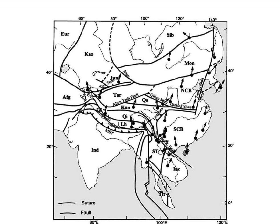
Figure P47 Simplified map (after Halim et al., 2003) of Eastern Asia showing the main sutures and faults (KF, Karakorum fault;
MBT, Main Boundary Thrust). The major blocks are: Afg, Afganistan; Eur, Eurasia; Inc, Indochina; Ind, India; Jun, Junggar; Kaz,
Kazakhtan; Kun, Kunlun; Mon, Mongolia; NCB, North China block; Qa, Qaidam; Qi, Qiangtang; Sib, Siberia; SCB, South China
block; ST, Shan Tai; and Tar, Tarim. Also indicated are the main locations where Cretaceous paleomagnetic data are available.
Declination is indicated by arrows (a thin line indicates geographic north, it is vertical because of the projection selected). Open
arrows are for areas suspected of major local scale deformation or unreliable paleomagnetic data. Solid arrows are thought to be
representative of the individual blocks at a larger scale.
818 PLATE TECTONICS, CHINA

voluminous eruption of the Emeishan basalts in southwestern China
around 250 Ma. Great quantities of Jurassic red beds in the Sichuan
Basin indicate that large neighboring mountains were being eroded
at that time. Northeast of the Dabie Shan in eastern Shandong Penin-
sula lies another ultrahigh-pressure coesite-bearing metamorphic suite.
Similarities in mineralogy of the Shandong and Dabie Shan meta-
morphic assemblages suggest they were once part of the same belt that
was later displaced about 500 km by the Tanlu fault in a left-lateral
sense. There are widely different estimates on the timing of collision
between the SCB and NCB based on geologic data. These estimates
vary from the Precambrian and Middle Paleozoic to the end of the
Paleozoic and earliest Mesozoic.
The SCB is commonly segregated into the Yangtze block to the
northwest and mobile belts to the southeast. In general, the division
between the Yangtze block and exotic terranes is demarcated south
of the exposed Meso- to Neoproterozoic low-grade metamorphic rocks
called the Jiangnan old land. Jiangnan rocks include ophiolite and
thick argillaceous turbidites that extend for over 1000 km. Using Sm
(samarium) and Nd (neodymium) isotopes, two laboratories have
dated two of the ophiloite suites at 1024 24 Ma and 935 34 Ma,
and 1034 24 Ma and 935 10 Ma, respectively. Li et al. (1995)
and Li (1998) suggested that the Yangtze Block and fold belts to
the southeast were amalgamated in the late Proterozoic at around
1000 Ma and are separated by a failed intracontinental rift activated
during the breakup of Rodinia at around 700 Ma. There is no well-
documented evidence of a Phanerozoic suture in the SCB. Hsu et al.
(1988) proposed a Mesozoic age collision model based on the discovery
of Mesozoic thrust structures in south China. This new interpretation
of south China tectonics has since led intensive debate.
Tarim and Junggar basins
Tarim is a rhombic-shaped basin, bounded by the Tianshan, (“Celestial
Mountains”), Kunlun and Altyn Tagh mountain ranges, with Precambrian
basement (3.3 Ga) exposed along its periphery (Hu and Rogers, 1992),
attesting to an extensive geologic history for the block. Tarim became
an inland basin since the beginning of the Mesozoic and it is presently
covered by the Takalamagan ( Takla Makan) desert, with Paleozoic rocks
occurring mostly along its northern and southern margins. Cambrian and
Ordovician strata are distributed mainly along the northern periphery of
the basin, whereas the Silurian, Devonian, Carboniferous and Permian
are mainly distributed in the northwestern part of the basin (Keping area).
The lithologies of these Paleozoic sequences are mainly dolomitic lime-
stone and red and yellow siltstones. The Mesozoic and Cenozoic strata
consist mainly of green sandstone and red mudstone and are distributed
in the northeast part of the basin (Kuche depression). A late Paleozoic
(Hercynian) orogeny was responsible for a general unconformity
between Paleozoic and Mesozoic formations.
Of the three major blocks that compose the tectonic framework of
China, Tarim, being the most inboard must have arrived at its present
position at least as early as any of the more outboard blocks and ter-
ranes. There is no clear suture zone between Tarim and the NCB.
Indeed, some geologists considered the NCB and Tarim to have
formed a rigid block since the Neoproterozoic because an almost con-
tinuous—“Hexizoulang”, equivalent to “Hexi Corridor”—of Precam-
brian and Paleozoic formations connects the NCB and Tarim. This
idea has been abandoned because available paleomagnetic data sug-
gest that these two blocks did not assume their present configuratio n
for sometime in the Mesozoic.
The Junggar Basin, often considered to be the southeast extremity of
the Kazakhstan Block, sits in a complicated region squeezed between
the Tarim Basin on the south, the Kazakhstan Block on the west, and
Siberia to the northeast. Unlike the Tarim Basin, there are no known
exposures of Precambrian rocks along the Junggar Basin margins.
However, some researchers have suggested that Junggar is underlain
by Precambrian crystalline basement, based entirely upon gravimetri-
cally determined depths to the Moho (e.g., Ren et al., 1987). Other
workers believe that it is underlain by a basement of structurally imbri-
cated Ordovician to Lower Carboniferous accretionary metasedimen-
tary rocks and oceanic crustal fragments. The oldest rocks in this
region are of Late Cambrian age (508 60 Ma). Middle Devonian
strata consist of spilitic pillow lavas interlayered with radiolarian
cherts and associated limestone horizons. Carboniferous units consist
mainly of marine to continental volcanic rocks interbedded with clas-
tics. Potassium-rich granitic plutons and their extrusive equivalents,
which have Permian K-Ar ages and Middle to Late Carboniferous
U-Pb ages are common in west Junggar. Permian rocks are mainly
continental clastics and volcanic extrusive. At many localities igneous
dikes of Permian age intrude the Carboniferous formations. Triassic
and Jurassic sequences are all continental clastics.
Collision between Tarim and Junggar along the Tianshan Range has
been inferred to be Early Permian in age, based on geological features
such as the termination of andesitic volcanism, the development
of unconformitites between late Early Permian and underlying units,
the intrusion of widespread syncollisional to postcollisional granites
in the Tianshan and the mixture of Angaran and Cathaysian flora
across the Tianshan.
Alashan/Hexi Corridor terrane
Situated west of Ordos, the Alashan/Hexi Corridor terrane is bounded
on the north by Central Asian Fold Belt and is separated from the Qai-
dam terrane by the Qilian Shan fold belt to the south. The western
boundary with the Tarim is not clearly delineated but is thought to
be within the northern Qilian Shan.
The oldest rock of the Alashan/Hexi Corridor terrane is Precambrian
(about 1850 Ma), as the Precambrian Longshoushan Formation in the
southern part is intruded by granites 1789 Ma in age (Yang et al.,
1986, p. 244). The first most recognized regional uncomformity in
southern Alashan area is between Middle and Late Cambrian (the
Xianshan Formation), which can be correlated to the coeval unconfor-
mity the Ordos basin, one of the most stable parts of the NCB. In con-
trast, this geologic pattern never penetrated into the Central Asian Fold
Belt, indicating the latter indeed is the geologic/block boundary.
Because of these geological observations, Alashan/Hexi Corridor terrane
is believed to be part of the NCB at least since the Late Cambrian and was
still receiving deposition while most other parts of the NCB were standing
higher during Late Ordovician to Early Carboniferous time.
Tibet and Qaidam basin
Tibet is a collage of continental terranes that accreted onto Eurasia
ahead of India. From north to south, the Tibetan terranes are the
Kunlun, Songpan-Ganze, Qiangtang, Lhasa, and Himalaya terranes,
the latter being actually part of the Indian subcontinent (see Figure
P47). Geologic studies suggest that these terranes collided with Eura-
sia at times progressively younging southward (Dewey et al., 1988;
Yin and Harrison, 2000; Davis et al., 2002). The amalgamation of
the Kunlun and Songpan-Ganze terranes is marked by a broad Early
Paleozoic arc on which was later superposed a Triassic arc (Burchfield
et al., 1992). The Qiangtang terrane accreted to the Songpan-Ganze
terrane along the Jinsha suture during the Late Triassic or Early Juras-
sic (Xiao et al., 2002), followed by the docking of the Lhasa terrane
against the Qiangtang block along the Bangong-Nujiang suture during
the Late Jurassic (Dewey et al., 1988), although the precise age of
suturing and subsequent reactivation by other collisions are still
debated. The Indian subcontinent in turn collided with these terranes
along the Yarlung-Zangbo suture during Late Cretaceous to Eocene
time (Murphy et al., 1997).
The Qaidam Basin is relatively a lower elevation region of the
northeast Tibetan Plateau bounded by the Altyn Tagh fault to the
northwest, the Kunlun fault to the south, and the Nan Shan fold-and-
thrust belt to the northeast. The nature of Qaidam’s basement is not
known because it is buried under thick cover strata and still no sufficient
PLATE TECTONICS, CHINA 819

borehole or geophysical data are available. Cover strata consist of
Cenozoic clastics of terrestrial facies. Tertiary continental sediments
in the Qaidam Basin reach several kilometers and serve as the main
oil producing layers in the basin. Qaidam’s mountain ranges probably
formed as ramp anticlines stacked upon a crustal-scale thrust fault.
However, compared to complexly deformed surrounding areas,
the Qaidam Basin shows only limited deformation of Cretaceous to
Tertiary sedimentary cover.
In summary, these geological observations provide fundamental
constraints on tectonics models of Chinese blocks. Although the geol-
ogy of the fold belts between these major Chinese blocks and terranes
has the potential of constraining the times of collisions more tightly
than the geology of the blocks themselves, the complexity of these
fold belts has led to widely different views of the tectonic history of
the region. With Gondwanaland in high southern paleolatitudes during
the Late Paleozoic and the Chinese blocks nowadays situated at mid-
northern latitudes, paleomagnetism is obviously an ideal tool by which
to test various Paleozoic paleogeographic models and to unravel the
later northward relative motions of these blocks and terranes if they
were part of Gondwanaland. As explored below, paleomagnetism
offers an independent—and complementary—source of constraints
in terms of the style of convergence and timing of amalgamation of
individual continental blocks.
Paleomagnetic constraints on tectonic history of major
chinese blocks
The tectonic relationship between crustal blocks can be constrained by
comparison of their paleomagnetic poles. If reliable poles of the same
age from two blocks are significantly different, one must conclude that
the two blocks have moved relative to one another sometime after
remanent magnetization was acquired. The converse is not necessarily
true, since it is not possible to assign longitudinal position to the paleo-
continents according to the GAD model.
Paleomagnetic investigation in China began in the early 1960s.
Great development in the acquisition of paleomagnetic data has been
made since early 1980s. In particular, the Cretaceous is well-studied
paleomagnetically both in terms of data quality and area distribution
(see Figure P47). The Global Paleomagnetic Data Base nowadays
has included studies from the Chinese literature, but there is still a
large variation in quality and reliability of the poles. Detailed reviews
of paleomagnetic poles (“paleopoles” for short) for Chinese blocks
have been given in several papers and books (e.g., Lin et al., 1985;
Zheng et al., 1991; Enkin et al., 1992; Zhao and Coe, 1987; Van der
Voo, 1993; Zhao et al., 1996, 1999; McElhinny and McFadden,
2000; Zhu and Tschu, 2001; Yang and Besse, 2001). Several addi-
tional paleopoles have become available since 2001. Up to 2003, a
total of 415 paleomagnetic poles have been published for Chinese
blocks and terranes. Some of these poles are still subject to debate
and interpretation. Any serious use of paleomagnetic data from China
should always involve independent evaluation and assessment of each
study. Thus, our intention is not to list the detailed references for these
415 paleopoles and discuss exhaustively the significance of data.
Readers are referred to the Global Paleomagnetic Data Base Version
4.6 (www.tsrc.uwa.edu.au/data_bases) for more information. These
paleomagnetic poles, from both Chinese and English language journals
and books, are briefly outlined below.
Paleomagnetic studies in the North China block
(+Hexi Corridor and Korea): 118 Poles
Quaternary (3 poles)
The Quaternary is represented by only three paleomagnetic poles: two
studies on the Chinese Loess Plateau in Shaanxi province and one
study on basalt flows in Shandong province.
Tertiary (7 poles)
Little work has been done on Tertiary rocks in North China as well:
Only a total of seven paleopoles have been reported from volcanic
and sedimentary rocks from Inner Mongolia, Hebei, Shandong, Shanxi,
and Gansu provinces. Most of the results passed reversal tests, although
the reliability of some of the studies can still be argued. The scarcity of
reliable paleomagnetic poles for these younger geologic time intervals
seems to be a result of the low research priority given to them.
Cretaceous (16 poles)
Twelve Cretaceous paleopoles have been reported from Ningxia,
Gansu, Shaanxi, Shanxi, Henan, Shandong, and Inner Mongolia of
the NCB. In addition, four studies on Cretaceous rocks from South
Korea have been published in the literature. These Cretaceous-aged
poles obtained from widely separated regions are consistent with each
other, suggesting that these areas occupied the same relative positions
in terms of paleolatitudes since the Cretaceous. Clockwise vertical-axis
block rotations of 30
of Korea relative to the NCB, however, are
implied by the Cretaceous data for Korea.
Jurassic (12 poles)
Only one Early Jurassic pole is available from Shaanxi province. Four
Late Jurassic poles have been published from three areas of Inner
Mongolia and Shanxi provinces and six paleopoles are available for
the Middle Jurassic that were derived from sedimentary rocks in
Shaanxi and Shanxi provinces. One Late Jurassic pole was reported
from Korea, again showing the region has rotated clockwise with
respect to China. There is still a worldwide deficiency of Early Jurassic
paleomagnetic poles, and North China is no exception.
Triassic (23 poles)
The Late Triassic in the NCB has only been studied in one region of
Shanxi province (2 poles). Nine paleopoles were reported from Middle
Triassic formations in Shaanxi and Shanxi provinces. Twelve paleo-
poles are available for the NCB from the Early Triassic sections in
Liaoning, Shandong, Shanxi, and Shaanxi provinces, but five of them
are clearly questionable.
Permian (26 poles)
A total of 19 Late Permian poles have been obtained from 14 sections
distributed over Hebei, Shanxi, Shaanxi, and Inner Mongolia. There
are also four Late Permian paleopoles available for Korea. In contrast,
only three Early Permian paleopoles are available from Shaanxi and
Shanxi province, which are significantly different from each other.
Like the Early Triassic, the distribution of the Late Permian paleomag-
netic poles is streaked along a small circle centered on the NCB, indi-
cating significant internal deformation that has caused local rotations.
Carboniferous (6 poles)
Two studies have reported Middle-Late Carboniferous results from
Shanxi and Shaanxi province for the NCB. None of them was consid-
ered reliable (Zhu and Tschu, 2001), underscoring that more paleo-
magnetic study of Carboniferous rocks should be a future research
focus. Four preliminary Late Carboniferous paleomagnetic poles were
reported from Korea.
Devonian and Silurian (5 poles)
Because of the great sedimentary hiatus during the Devonian and Silur-
ian for the NCB, three studies were conducted in the Alashan/Hexi
Corridor in the Ningxia Hui Autonomous region on Middle to Late
Devonian and Silurian red beds. Two Middle to Late Devonian and
820 PLATE TECTONICS, CHINA

three Middle to Late Silurian paleopoles have been published from
these studies.
Ordovician (10 poles)
Nine paleopoles have been obtained from Liaoning, Hebei, Shandong,
Shaanxi provinces and the Ningxia Hui Autonomous region that are
distributed along a small circle centered on the NCB, indicating local
rotations. One Early Ordovician pole was obtained from Korea. There
was a dispute on the magnetic polarity of the stable magnetization
from the Ordovician rocks in China, which was resolved by a
recent magnetostratigraphic study on rocks spanning the Cambrian/
Ordovician boundary and into early Ordovician.
Cambrian (10 poles)
Ten Cambrian paleopoles have been reported for the NCB that were
derived from rock formations from Liaoning, Shandong, Shanxi,
Shaanxi, and Ningxia. These poles can be grouped into three clusters.
One group (3 poles) is close to the Triassic pole of the NCB and with-
out stability tests. These poles are suspicious because they may have
been remagnetized in the Triassic. Poles in the second group fall near
the equatorial area of the western Atlantic while those in the third
group are in the eastern Atlantic. The scatter of paleopoles may result
from the local rotation of sampling areas or unsatisfactory removal of a
second magnetization component.
Paleomagnetic study in the South China
block: 204 poles
Quaternary (5 poles)
Early Quaternary poles were obtained from a basalt formation in
Jiangsu (1 pole) and clays from Yunnan (4 poles). No details concern-
ing sampling sites and laboratory work were given.
Tertiary (24 poles)
Tertiary paleomagnetic data are numerous for the SCB. A total of
24 paleopoles are available for the SCB, which come from red beds
and basalt formations in Yunnan, Guangdong, Sichuan, Hubei, Hunan,
Zhejiang, and Jiangsu provinces.
Cretaceous (26 poles)
Of the 26 paleopoles determined for the Cretaceous, 12 come from
sedimentary rocks in Sichuan province. The rest are obtained from
red beds and mudstones in Guangxi, Fujian, Yunnan, and Guangxi
provinces. There are two poles obtained from volcanic rocks in
Zhejiang and Hong Kong, respectively.
Jurassic (31 poles)
Fourteen poles have been published for the Late Jurassic of the SCB,
which were obtained from sandstone and mudstone formations in
Zhejiang, Sichuan, Anhui, and Yunnan provinces. The Middle Jurassic
is represented by 11 paleopoles that come from sedimentary and volca-
nic rocks from Guangxi, Hubei, Anhui, Sichuan, Guizhou, and Hong
Kong. Six paleopoles from sandstone formations in Sichuan, Hubei,
Anhui, Guangxi, and Yunnan are available for the Early Jurassic.
Triassic (49 poles)
Fifteen Late Triassic poles have been isolated from siltstone sites in
Sichuan and Yunnan provinces. Nine Middle Triassic poles were
reported from limestone and red sandstone in Hubei, Jiangsu,
Guizhou, Sichuan, Hunan, and Guangxi provinces. Most of poles from
the Early Triassic limestone formations are from Sichuan. It is impor-
tant to note that Early Triassic poles from limestone and sandstone
formations of Jiangsu and Zhejiang in the eastern extreme of the block
are coherent with the poles from west (Sichuan), suggesting that the
SCB has behaved more or less rigidly since at least this period.
Permian (30 poles)
Many high-quality paleomagnetic data for the Late Permian have been
presented since McElhinny et al.’s (1981) pioneering paleomagnetic
paper on the Emeishan Basalt from Sichuan. Those poles are now
from both the Emeishan basalt from Yunnan and Guizhou provinces
and red limestone and sandstone from Hubei, Zhejiang, Guangdong,
and Sichuan. In contrast, only one Early Permian pole is reported from
a limestone section in Hubei province. It is worth mentioning that, like
many other fields in Earth sciences, progress in the paleomagnetic data
of China has grown through repeated trials, criticisms, and improve-
ments. Some studies may encompass entire lifetimes of devoted work.
The debate on the age of magnetization of the Late Permian Emeishan
Basalt from the SCB is a case in point. Debate has continued for the
last 15 years as to whether the observed magnetic direction is primary
or secondary. Although a reported positive conglomerate test by
Huang and Opdyke (1995) effectively refuted the suspicion that the
directions from the Emeishan Basalt may represent a remagnetization
of Triassic or even Jurassic age, it may still require more extensive
investigations to unequivocally settle the question.
Carboniferous (5 poles)
Out of the 5 Carboniferous poles published from limestone and mud-
stone formations in Zhejiang, Yunnan, and Fujian provinces, none of
them, however, can demonstrate the age of magnetization with cer-
tainty, reflecting the still insufficient inventory of Chinese paleomag-
netic data.
Devonian (5 poles)
Five poles of Devonian age for the SCB are reported from sandstone
formations in Zhejiang, Jiangsu, Yunnan, and Sichuan. The data set is
relatively small and also subject to debate. Only one pole was selected
by McElhinny and McFadden (2000) to be included in their book.
Silurian (8 poles)
Silurian poles for the SCB were reported from red beds, sandstone,
and limestone in Guizhou, Zhejiang, Hubei, Yunnan, and Sichuan
provinces. These poles have been all determined using the modern
methods and analytical techniques.
Ordovician (8 poles)
Eight Ordovician paleomagnetic poles have been reported for South
China that were derived from limestone and sandstone in Zhejiang,
Hubei, Yunnan, and Sichuan province. These poles generally have
poor quality.
Cambrian (5 poles)
The collected Cambrian poles were derived from rocks from Zhejiang,
Hubei, and Yunnan provinces. The poles are very different from Cam-
brian poles of the NCB, suggesting that North and South China were
two different continental blocks during Cambrian.
Paleomagnetic study in the Tarim and Junggar
basins: 52 poles
Quaternary (1 pole)
Only one study of Quaternary basalt from the southeast of the Tarim
Basin has been published. The age of the basalt is still in dispute,
but it seems reasonable for it to represent the Quaternary.
PLATE TECTONICS, CHINA 821

Tertiary (11 poles)
Tertiary paleomagnetic poles for Tarim were mainly obtained from the
Aertushi region of western Tarim, the Kuche depression of northwest
Tarim, and the Maza Tagh range in the central Tarim Basin. Up to
1990, the paleomagnetic database for Tarim was very sparse. The last
13 years saw a major increase in the number of paleomagnetic data for
Tarim, which is rather fortunate because tectonic rotations caused by
the Indian collision might be constrained by such data.
Cretaceous (10 poles)
Eight Cretaceous poles were reported for Tarim, all of them from the
Kuche depression in northwestern Tarim. Of the eight poles, six were
derived from red beds and two were from basalt formations in the
Tuoyun area of western Tarim. Two Cretaceous poles were published
for the Junggar basin, which are close to Cretaceous poles for Tarim.
Jurassic (4 poles)
One Late Jurassic and three Middle Jurassic pole are available for
Tarim. Both were derived from red bed formations in southwestern
Tarim. No coeval pole is available for the Junggar basin.
Triassic (3 poles)
The Triassic of Tarim is represented by three poles (one each in the
Late, Middle, and Early Triassic). Among them, only the Late Triassic
was well studied through a magnetostratigraphic investigation.
Permian (14 poles)
Permian paleomagnetic poles for Tarim are mainly from volcanic
rocks in the Aksu, Keping, and Kuche areas of western Tarim, with
7 poles for Late Permian and 5 poles for the Early Permian. Two Late
Permian poles have been reported for the Junggar Basin, which is con-
cord with the Permian poles for Tarim. The number and quality of Per-
mian paleopoles for Tarim is quite impressive, suggesting one should
treat these poles seriously. No paleopoles older than Permian were
reported from the Junggar basin.
Carboniferous (4 poles)
Four Carboniferous paleopoles are available for Tarim, which were
all derived from sedimentary rocks (limestone and sandstone) from
South western Tarim.
Devonian (3 poles)
Three Devonian paleomagnetic poles were reported for the Tarim,
obtained from both the north and south rims of Tarim.
Silurian (3 poles)
There are three middle Silurian poles for Tarim. The magnetization is
dominated by an extremely weak, recent-field component of magneti-
zation that was carried by goethite. Clearly, these poles are unaccepta-
ble for tectonic study.
Ordovician (1 pole) and Cambrian (1 pole)
Although the number of poles for these two periods is extremely
sparse, the reported poles each pass fold and reversal tests and place
Tarim in low paleolatitudes during Cambrian and Ordovician.
Paleomagnetic studies in the Tibet and Qaidam
basin: 38 poles
Since the early 1980s, paleomagnetic investigation has been an impor-
tant aspect of all the major geologic expeditions conducted on the
Tibetan plateau. While paleomagnetic investigations of the Cretaceous
and younger rocks from the plateau have yielded useful constraints for
the Lhasa and Qiangtang terranes (Achache et al., 1984; Lin and
Watts, 1988; Otofuji et al., 1989; Huang et al., 1992; Chen et al.,
1993), studies on the Paleozoic formations were often hampered by
lack of favorable lithology, multiphase deformation, and metamorph-
ism that has obliterated the primary magnetization (Lin and Watts,
1988; Otofuji et al., 1989; Huang et al., 1992). Triassic and Jurassic
paleomagnetic directions also tend to be remagnetized (Chen et al.,
1993). As a result, there are a total of 8 Tertiary and 13 Cretaceous
paleomagnetic poles for Tibet.
Among the Late Cretaceous paleomagnetic results from Tibet, those
reported from south Tibet (Achache et al., 1984), east Qiangtang
(Huang et al., 1992), and west Qiangtang (Otofuji et al., 1989; Chen
et al., 1993) appear to have high quality, each with positive fold test
result. However, there is a serious problem in interpreting these Late Cre-
taceous data in terms of paleolatitude. The study on the Late Cretaceous
Takena red beds and Paleocene andesites of the Lhasa Block yielded a
paleolatitude of 15–20
N for Lhasa. It should be pointed out that the
Paleocene Lingzizong volcanics in the Lhasa area give consistent result
(with positive fold and reversal test) with the underlying Cretaceous
strata (Achache et al., 1984) and provide a notable example that both
red beds and volcanic rock in the Lhasa area recorded the same ancient
magnetization. Lin and Watts (1988) sampled the Takena formation in
the Linzhou area as well as Late Cretaceous volcanic units in Nagqu
and Qelico. Their data pass a fold test and give slightly lower paleolati-
tudes (7.6 3.5
N), but still similar to the results of Achache et al.
(1984). If we use the mean of these three results, the paleolatitude of
Lhasa in the Late Cretaceous would be about 12.5
N. A comparison
of this value with that predicted by the reference pole (Besse and
Courtillot, 1991) would confirm the conclusion of Achache et al.
(1984, p. 10335) that crustal shortening of the order of 2000 km has
occurred between Lhasa and Eurasia since the Late Cretaceous. Calcula-
tions of shortening using the Early Tertiary Linzizong volcanic rocks
yield a similar amount of northward displacement of the Lhasa terrane.
This is compatible with other geophysical and geological estimation that
India has moved about 2500 km northward about 50 Ma (e.g., Dewey
et al., 1988). However, when comparing the paleolatitude of Lhasa with
that of west Qiangtang (Chen et al., 1993) and Tarim/Junggar (Li et al.,
1988; Chen et al., 1991), the data suggest that there is no net crustal
shortening between Lhasa and west Qiangtang/Tarim/Junggar from the
Late Cretaceous to present. In other words, the entire 2000 km of north-
ward displacement of the Lhasa block suggested by the Late Cretaceous
paleomagnetic data would have to be taken up in the region to the north
of Junggar. This would conflict with existing understanding of the for-
mation of the Tibetan plateau by either the crustal shortening model
(Dewey et al., 1988) or the tectonic extrusion model (Tapponnier
et al., 2001), or a combination of the two (Harrison et al., 1992). In addi-
tion, there is no geologic evidence to suggest a candidate place between
Siberia platform and Junggar/Tarim to accommodate crustal shortening
of this magnitude in the Tertiary. If the configuration for most or all of
the Tibetan plateau has been created by the India/Asia collision, then
the Late Cretaceous paleomagnetic results from Lhasa and west Qiang-
tang /Tarim/Junggar cannot both be correct. Obviously, further work is
badly needed to solve this problem, and a reliable paleomagnetic pole
from central Qiangtang would provide a direct test.
For the Qaidam Basin, there are 5 Jurassic, 3 Cretaceous, and
9 Tertiary poles reported from paleomagnetic investigations of the
basin. These studies were designed to detect possible clockwise rota-
tion of Qaidam basin, as implied by extrusion models. Rotation within
the Qaidam-Altyn Tagh region is very controversial, and existing
paleomagnetic data are contradictory. Halim et al. (2003) presented
one Late Jurassic pole from red beds in Huatugou of Qaidam basin.
This pole indicates negligible northward convergence of the Qaidam
block with respect to Tarim since Late Jurassic times, but implies a
significant relative clockwise rotation of the studied area with respect
to Tarim (16
). Similarly, Chen et al. (2002) reported that three widely
822 PLATE TECTONICS, CHINA

spread areas in Qaidam exhibit 20
clockwise rotations during the Late
Oligocene-Late Miocene time. However, recent study from the east end
of the Altyn Tagh fault by Gilder et al. (2001) shows that area has
rotated 27
5
counterclockwise with respect to the Eurasian refer-
ence pole during the last 19 Ma. Otofuji et al. (1995) also suggest that
their sampling sites along the Altyn Tagh fault showed 7.4
5.2
counterclockwise rotation during the last 1.0 Ma. On the other hand,
Dupont-Nivet et al. (2002, 2003) and Rumelhart et al. (1999) argue
for no significant Neogene vertical-axis rotation in northern Tibet since
Eocene. These results would contradict extrusion models which imply
clockwise rotation of Qaidam basin at rates approaching 1
/Ma.
Paleo-positions of Chinese blocks
Although a great number of Late Mesozoic and Cenozoic paleomag-
netic results are available, the current paleomagnetic data base for
China is still limited to allow a satisfactory interpretation of the ques-
tions concerning the paleogeography of China and the implications for
Gondwanaland. Because many studies are performed at a single local-
ity or over a small region and are of variable quality, paleomagnetists
must critically assess and update the previously published data from
China and Eurasia in order to better understand the tectonic relation-
ship between the Chinese blocks and their relative motions with
respect to Eurasia (i.e., Europe, Siberia, and Kazakhstan) during the
Phanerozoic. Basic criteria for an acceptable paleomagnetic pole deter-
mination should include (i) age of the magnetization; (ii) structural
control; and (iii) paleomagnetic laboratory treatment (demagnetization)
of sufficient samples.
After such evaluations and assessments of each published study, the
current state of paleomagnetic knowledge can be synthesized as
follows: during Early (530 Ma) and early-middle Late Cambrian
(505 Ma), the paleolatitudes of South China, Tarim, and Australia permit
them to be next to each other. North China can be placed between
Siberia and Australia. All these blocks were in the area around the
equator. Between late Middle to early Late Cambrian (505 Ma),
Tarim, North and South China Blocks lay closer to Australia and
shared close trilobite affinities until Late Cambrian (490 Ma). The
counterclockwise rotation of Gondwanaland during the Cambrian
was reversed during the Ordovician. The change in sense of rotation
occurred at the Cambro-Ordovican boundary. The North and South
China Blocks, and Tarim, remained in low latitudes, and rotated sinis-
trally along the Cimmerian margin of Gondwanaland towards posi-
tions they are inferred to have occupied later on the basis of faunal
relationships.
By Early Silurian time (430 Ma) Siberia remained in the vicinity of
the equator but has moved slightly northward to a position north of the
equator. Gondwanaland appears to have moved southward and rotated
clockwise. North China may also have rotated clockwise and appears to
be compatible with a position next to the northern margin of Australia,
which also fits the distribution of freshwater fish fauna on the two con-
tinents. While South China remains in roughly the same position,
Tarim appears to have rifted off the SCB by rapid clockwise rotation
and northward displacement.
At Middle Devonian time (380 Ma) the location of South China
suggests that it may have rifted off Australia. Tarim is continuing its
northward journey. Siberia has also drifted northward and rotated
clockwise. North China, on the other hand, is still on the equator.
The development of highly endemic vertebrate faunas on both the
North and South China Blocks indicates that these two blocks were
separated from Gondwanaland during Early-Middle Devonian.
Later at the Late Devonian time (354 Ma), Gondwanaland began
to drift rapidly across the south pole, and by mid-Carboniferous
(320–310 Ma), it has collided with Laurussia to start assemblage the
supercontinent Pangea. It was for the first time that Australia had been
drifted close to the south pole during the Paleozoic. The major Chinese
blocks remained in low and medium paleolatitudes and started to
develop their distinctive Cathaysia flora. The Late Carboniferous poles
for Tarim and Eurasia are in agreement, suggesting that these regions
could have started the process of accretion by Late Carboniferous time.
The paleogeography of the Early Permian (280 Ma) remained
more or less the same as the mid-Carboniferous, except that Siberia
collided with Laurussia along the Urals. Mongolian terranes accreted
to the North China, the first phase of continental collision between
the NCB and SCB at their eastern ends started soon. Supercontinent
Pangea was complete at this time.
Pangea endured from 280 Ma to 175 Ma when the first seafloor
spreading began in the North Atlantic Ocean. During this time, several
Tibetan terranes (Kulun, Songpan-Ganze, and Qiangtang) accreted to
Eurasia. The apparent polar wander paths for Eurasia and North and
South China converge during the Late Jurassic (150 Ma) and are
tightly grouped throughout the Cretaceous and Tertiary, implying that
large relative motion (translation and/or rotation) between the blocks
was accomplished by Late Jurassic. On the other hand, although the
paleolatitudes for Tarim and Eurasia have been similar since Carboni-
ferous time, a close inspection reveals that there is a significant differ-
ence between the Late Permian, Early Triassic and Late Jurassic
through Cretaceous poles for Eurasia/Siberia and Tarim, indicating
relative motions between Tarim and Eurasia.
Tectonic models inferred by the paleomagnetic data
The paleomagnetic results available from China allow plausible tec-
tonic models to be constructed for the amalgamation of the Chinese
blocks with themselves and with Eurasia (Zhao and Coe, 1987;
Zhao et al., 1996). The collision between Siberia/Eurasia and the
Mongolia-NCB initially occurred in the Permian near the western
end of their boundary in the Irtysh-Zaysan region (50
N, 75
E), which
is near the edge of the Kazakhstan Block (in today’s geographical
frame). Suturing progressed eastward as the Mongolia-NCB rotated
counterclockwise about 90
in relation to Eurasia during the Early
Mesozoic with a scissors-like motion (see Figure P48). The amalga-
mation of North and South China took place in the Late Permia n by
a similar but antithetic mechanism, with collision first occurring near
the eastern end (about 30
N, 120
E) of the Qinling Fold belt and dia-
chronously suturing from east to west due to a clockwise rotation of
65
of South China relative to North China.
Early Triassic paleomagnetic poles for all continental blocks are
very similar to those for the Late Permian, consistent with the same
scissor model discussed above and reinforcing the tectonic model.
Reliable Middle and Late Triassic paleomagnetic data for the NCB,
SCB, and Eurasia are still relatively sparse. Little change appears to
have taken place by Middle Triassic time, with about 65
of rotation
still left between Eurasia and the NCB to reconcile their poles.
In the Early Jurassic, more than half of the Qinling Sea between the
NCB and SCBs was subducted, and so was the Mongol-Okhotsk
Ocean between Eurasia and the NCB. Therefore, paleomagnetic data
suggest that most of the relative rotation between the Chinese blocks
took place during the Late Triassic and Early Jurassic. By the Middle
Jurassic, the Qinling Sea is almost completely closed, although this
may not be entirely correct due to the relatively large uncertainty in
the SCB poles. The Late Jurassic and Early Cretaceous paleomagnetic
poles for the NCB and SCB are statistically indistinguishable at this
time, suggesting that accretion between the two blocks was accom-
plished some time between the Middle and Late Jurassic. However,
the Chinese blocks were still significantly south of Siberia, with
1000 km of the Mongol-Okhotsk Ocean to be closed north of Mon-
golia. The final closure of the Mongol-Okhotsk Ocean took place
sometime in Cretaceous.
The tectonic model mentioned above contradicted widely held views
at the time that the NCB and SCB were joined by the Devonian at the
latest and that the Central Asian Fold Belt, which runs across North
China just north of 40
N, is the zone where China was sutured to Siberia
in Permian time. Rather, the paleomagnetic evidence suggested that in
both cases suturing was completed much later, in Mid-Mesozoic time,
PLATE TECTONICS, CHINA 823
and that it was a composite Mongolia-North China plate, not the NCB,
that became sutured to Siberia Mesozoic time in a zone much further
north along what is termed the South Siberian Fold Belt. Furthermore,
the paleomagnetic data suggested in both cases a very simple mechan-
ism involving a scissors-like closing of the intervening ocean basins
by antithetic senses of rotation about the points of initial collision at
the eastern and western ends of the convergence zones of the southern
and northern suture zones, respectively. These paleomagnetic models
have been reinforced by many later studies and backed up by reinterpre-
tation of relevant geological information, such as the propagation of
abrupt regional and local changes from marine to continental basin
deposition and of syncollisional to postcollisional alkalic granites in
the collision zone. Therefore, here is a case where paleomagnetism
has again provided first-order contributions in deciphering continental
collision and amalgamation.
Paleomagnetic implications concerning tectonic
controversies in China
Implications for the duration of continent-continent
collisions
As noted above, the scissor model of NCB-SCB collision based on paleo-
magnetic data matches the change in sedimentary style from marine to
continental on the northern margin of the SCB. Both paleomagnetic and
geologic data agree that the onset of collision occurred in Permian to
Triassic time. The data sets diverge, however, regarding the end (duration)
of the collision, with the paleomagnetic data suggesting younger esti-
mates (Middle Jurassic) than geological indicators (Late Triassic) by
20–30 Ma. Part of the discrepancy could be the lack of more reliable Late
Triassic to Middle Jurassic paleomagnetic data from both blocks. Further
studies could show that the paleomagnetic poles of Early Jurassic or Late
Triassic age are indistinguishable, thereby bringing the paleomagnetic
and geological data sets closer into agreement. On the other hand, it is
possible that the rotation suggested by the paleomagnetic data also
includes postcollisional shortening between the two blocks. Taking the
ongoing India-Asia collision as an example of typical continent-continent
collisions, deformation and shortening could continue at least 50 Ma
after initial contact of the two plates. Such postcollision shortening
could also potentially lead the age of initial India-Asia collision based
on paleomagnetic data to be somewhat younger than those based on
stratigraphic data.
Tertiary low-paleolatitude dilemma of western China
As the Chinese paleomagnetic database grows, several research teams
are continuing to discover the outstanding regional disagreement
between the observed and predicted Cenozoic paleomagnetic directions
from red bed formations in western China. The inclinations of stable
magnetization in Cretaceous red beds from Tarim and surrounding
region’s are somewhat shallower than expected using Besse and
Courtillot (2002) APWP Cretaceous reference pole for Eurasia, whereas
the Tertiary red beds are even more shallow using the corresponding
Tertiary reference pole. The inclinations translate to anomalously low
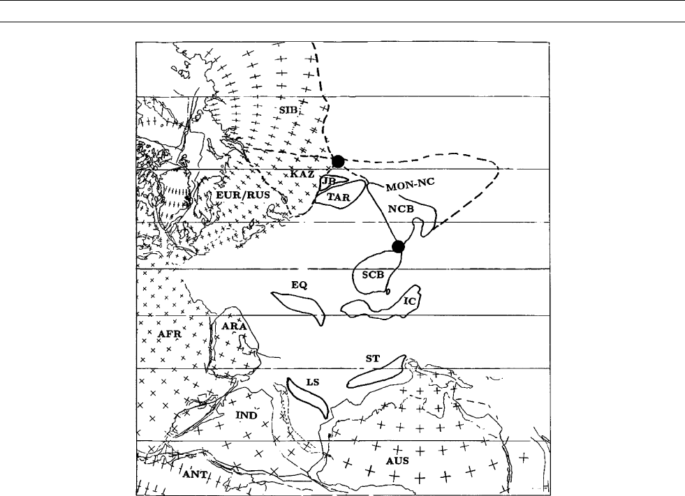
Figure P48 Schematic reconstruction of Mongolia-North China (MON-NC), Europe-Siberia-Kazakhstan (EUR-SIB-KAZ), Tarim (TAR),
Junggar Basin (JB), South China block (SCB), Africa (AFR), Arabian Shield (ARA), India (IND), Australia (AUS), Antarctic (ANT), the East
Qiangtang (EQ), Lhasa (LS), Indochina (IC), and Shan-Thai (ST) blocks in Late Permian time. Mecator Projection. After Zhao et al.
(1990).
824 PLATE TECTONICS, CHINA

paleolatitudes. If all these paleomagnetic data, the ages, and the GAD
hypothesis were correct, then in the Cretaceous Tarim would have been
somewhat further south with respect to Eurasia compared to its present
situation, relatively even further south when the Tertiary red beds were
magnetized, and then had to move to its present more northerly relative
position after that time. This implies a southward (extensional) relative
displacement away from Eurasia in the period between the times when
the Cretaceous and Tertiary redbeds were magnetized, and significantly
more northerly (compressional) relative displacement toward Eurasia
after the Tertiary red beds were magnetized, a scenario that is geologi-
cally indigestible. Recent results from Cretaceous red beds in the
Hexi-Corridor (central China) show that there is no evidence that red
beds there suffered the same inclination shallowing as the neighborhood
Cenozoic red beds to the west (Sun et al., 2001; Chen et al., 2002). A
review of published poles also confirms previous analyses that red beds
from South and North China do not reveal the shallow inclination and
these blocks (plus Mongolia) and Siberia have not undergone very sig-
nificant internal deformation since the Cretaceous (Besse and Courtillot,
2002). It appears that some red beds suffer from inclination error, and
others do not. The task is thus to develop ways to identify which of
the Tertiary red beds do and do not undergo inclination shallowing.
The most direct way would be to obtain reliable Tertiary paleomag-
netic results from volcanic rocks and compare them with inclinations
of coeval red beds in the same study area. Two such studies have
reported contrasting results: (1) the Paleocene Lingzizong volcanics
in the Lhasa area give consistent result (with positive fold and reversal
test) with the underlying Cretaceous strata (Achache et al., 1984), pro-
viding a notable example that both red beds and volcanic rock in the
Lhasa area recorded the same ancient magnetization; and (2) Early
Cretaceous red beds and underlying basalt flows from Tarim and cen-
tral Asia fold belt (Gilder et al., 2003) have directions that pass both
fold and reversal tests, but the mean paleolatitude of the Early Cretac-
eous red beds is 11
lower than that of the Early Cretaceous basalts.
Obviously, more studies should be conducted on Tertiary volcanic
and red sedimentary rocks from the same area.
Tectonic affiliation of the Korean peninsula
The question about the Korean Peninsula’s affinities with both the
NCB and SCB is one of the highly charged controversies in Asian
tectonics. The lack of knowledge about this question hampers our
understanding concerning the models of collision of eastern Asian
blocks and their paleogeographic settings. Pre-Cretaceous paleomag-
netic poles for Korea are all different from each other and make it
difficult to compare the coeval poles from the NCB and SCB. At first
glance, Triassic and Jurassic paleomagnetic poles for Korea published
prior to 1994 are indeed somewhat similar to coeval ones from the
SCB, and this was perhaps the reason to lead some workers to suggest
that Korea and South China may have behaved as a single tectonic
block since the Triassic. However, all these poles that apparently cor-
respond to the SCB poles were derived from rocks within the Okchon
zone, which is known to be a site of severe deformation in the Meso-
zoic. In fact, Cretaceous remagnetization of Carboniferous rocks has
been concluded for several previous published results. Although
detailed structural analysis and mapping are still insufficient to unravel
the kinematic history of the Okchon fold belt and assess its effects on
these paleomagnetic poles, the proximity of these poles to the SCB
poles may be a coincidence.
If one leaves out these poles derived from the Okchon zone and
merely retains those poles derived from areas bordering the Okchon,
a striking feature between the Korean and NCB poles emerges: the
Late Permian, Early Triassic, and Late Jurassic poles for Korea are
systematically displaced some 30
eastward with respect to the coeval
poles of the NCB. A 30
clockwise rotation of Korea about a vertical
axis brings these poles into general coincidence with those coeval
poles for the NCB. Thus, paleomagnetic study suggests that the whole
region was part of the North China landmass at least as early as Late
Permian and rotated clockwise by about 30
with respect to the
NCB during the Cretaceous (Zhao et al., 1999).
It is apparent that the rotated (or corrected) poles show large appar-
ent polar wander motion of Korea between Early Triassic and Late Jur-
assic, replicating those found in the paleomagnetic results from the
NCB. Late Jurassic paleomagnetic poles for the NCB, SCB, and Korea
are statistically indistinguishable, reinforcing the hypothesis that the
accretion of the NCB and SCB was finished at this time. Thus, the
NCB-Korea connection is not only consistent with the majority geolo-
gic observations, suggesting affinities between the two blocks, but also
consistent with the collisional tectonic history of the eastern Asian
margin derived from paleomagnetic data.
Terrane accretion between east and west Qiangtang
Comparison of paleomagnetic data obtained from east and west Qiang-
tang shows a problem that obstructs our understanding of terrane
accretion in Tibet. The Cretaceous paleolatitudes of Otofuji et al.
(1989) and Huang et al. (1992) in the Markam area of east Qiangtang
are similar to the expected paleolatitudes for the sampling locality. The
data would suggest that east Qiangtang was 21
10
farther north
than expected for Lhasa and 22
11
farther north than expected
for western Qiangtang. Taken at face value, these data would suggest
that no significant crustal shortening has taken place north of east
Qiangtang since at least the Late Cretaceous. The 2000 km shortening
of Lhasa must have been accommodated between the Qiangtang and
Lhasa blocks in the Tertiary. On the other hand, west Qiangtang must
be close to the Lhasa trerrane in Late Cretaceous time, so there should
be a suture between east and west Qiangtang. Huang et al. (1992)
interpreted their paleomagnetic observation in terms of a giant right-
lateral transpressional zone advocated by Dewey et al . (1998). Chen
et al. (1993), on the other hand, suggested that east Qiangtang may
have belonged to South China or to a block that was separated from
western Qiangtang.
Tectonic rotational history of northern Tibet
A closely related question is the tectonic rotational history of northern
Tibet, which is often related to uplift and deformation. Magnetic decli-
nations, which are not typically affected by depositional compaction,
can be compared to expected magnetic directions to assess the extent
to which regions within the northern Tibetan plateau have rotated
about vertical axes with respect to stable Eurasia. In eastern Tibet,
Cretaceous and Tertiary paleomagnetic data indicate large amounts—
in the order of 40
—of clockwise rotation in the eastern Himalayan
syntaxis (e.g., Achache et al., 1984; Huang et al., 1992), which is con-
sistent with right-lateral simple shear and associated oroclinal bending.
However, paleomagnetic data obtained from Cretaceous and Tertiary
red sedimentary rocks of western Qiangtang (Chen et al., 1993) show
no significant Neogene vertical-axis rotation in northern Tibet since
the Late Cretaceous. Thus, all paleomagnetic data for tectonic rotations
are not in agreement; some of them are apparently contradicting extru-
sion models that imply clockwise rotation of the region. These existing
results, however, should be incorporated with forthcoming new results
to advance our understanding of the growth history of the Tibetan
plateau.
Summary
Plate tectonics views the whole Earth as a dynamic system in which
the internal heat drives lithospheric plates in relative motion with
respect to each other. Paleomagnetism enables geologists to view
important aspects of continental movements in the past namely,
changes in latitude and orientation relative to the geographic poles. It
is important to realize the crucial role that paleomagnetic studies in
China have played in providing the tectonic framework that guides
geological investigation and interpretation. Until McElhinny et al.’s
pioneering paleomagnetic paper in 1981 revealed discrepancies in Late
PLATE TECTONICS, CHINA 825