Elsevier Encyclopedia of Geology - vol I A-E
Подождите немного. Документ загружается.

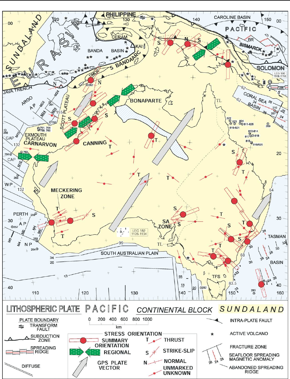
Figure 25 Tectonic map of the continental lithosphere of Australia-New Guinea (yellow) and Sundaland (part of the Eurasian Plate;
yellow) and the surrounding oceanic lithosphere (blue), including the Pacific Plate and the Solomon sub-Plate to the north-east. The
ocean is marked by Deep Sea Drilling Project and Ocean Drilling Program sites (bullseyes) and selected seafloor-spreading magnetic
anomalies. The age of the continent–ocean boundary is given in Ma. The oblique blue band across northern Australia signifies
Miocene or younger sediment. Also shown are the orientation of maximum horizontal stress and the plate vector. AP, Abyssal Plain;
Continued
AUSTRALIA/Phanerozoic 231
and Hervey Basins behind the Baldwin arc. The
fore-arc basin and accretionary prism (Figure 2viii)
extended north as the Connors–Auburn arc.
In central Australia, the uplifted Arunta Block shed
alluvial fans to the south, which were themselves
folded and eroded. Fans in the Munyarai Trough
were likewise shed from the overthrusting Musgrave
Block. The eastward flow from central Australia
through the Adavale Basin swung northwards (parallel
to the Connors–Auburn arc) in the Drummond Basin
and debouched in the Broken River Embayment,
which was deformed in the latest Devonian.
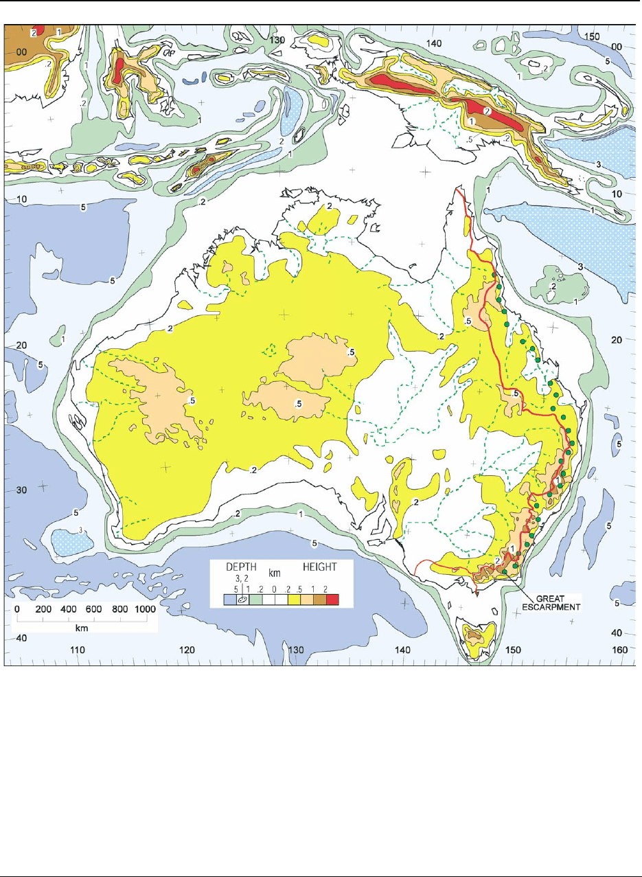
Figure 26 Morphology of Australia and the neighbouring land, sea, and ocean. Shown in eastern Australia are the Great
Escarpment (green dots) and the drainage divide (red line). Reproduced with permission from Veevers JJ (ed.) (2000) Billion-Year
Earth History of Australia and Neighbours in Gondwanaland
. Sydney: GEMOC Press.
BR, Bismarck Rift; C, Cuvier; G, Gascoyne; J, Jerboa-1; NP, Naturaliste Plateau; SA, South Australia; TL, Tasman Line; TFS, Tamar
Fracture System; WP, Wallaby Plateau; WR, Woodlark Rift. Reproduced with permission from Veevers JJ (ed.) (2000)
Billion-Year Earth
History of Australia and Neighbours in Gondwanaland
. Sydney: GEMOC Press.
232 AUSTRALIA/Phanerozoic
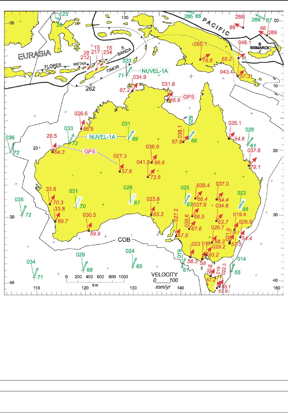
Figure 27 Velocities of sites on the Australian Plate and adjacent Pacific and Eurasian plates. Red arrows indicate velocities
measured by GPS; double-shafted green arrows indicate velocities calculated from NUVEL-1A at selected 10
crosses. For each
arrow, the fine line is the north azimuth, the three-digit numeral the bearing, and the italicized numeral the velocity in mm year
1
. The
thrust line of Timor passes through DSDP (Deep Sea Drilling Project) site 262. Reproduced with permission from Veevers JJ (ed.)
(2000)
Billion-Year Earth History of Australia and Neighbours in Gondwanaland. Sydney: GEMOC Press.
Table 1 The three stratitectonic regimes in the development of Phanerozoic Australia
Regime Age (Ma) Platform stratigraphy Tectonics Latitude
Potoroo 99–0 Quartz, carbonate, and evaporite Post-Pangaean High to tropical
Innamincka 320–99 Glacigenic and coal measures Pangaean Polar
Uluru 544–320 Quartz and carbonate Gondwanaland Tropical
AUSTRALIA/Phanerozoic 233

The North China terrane broke off the Palaeo-
Tethyan margin. In the north, the Goulburn Graben
was initiated; the Bonaparte Basin was rejuvenated
and Frasnian alluvial fans were deposited at the
foot of a fault and succeeded by a Famennian reef
complex. In the Ord Basin, sand was deposited south-
wards from the same fault block. In the northern
Canning Basin, gravel fans from the Kimberley Block
mingled with a reef complex on a platform in
front of a deep axis; to the south, the paralic Tan-
dalgoo Formation was deposited in an arm of the
sea. In the Carnarvon Basin, shelf limestone and in-
shore quartz sand give way in Pendock-1 to reef
carbonate. Reworked Late Devonian conodonts in
the Perth Basin suggest that the shoreline extended
southwards.
Carboniferous (350–300 Ma)
South-eastern Australia was subjected to an Early
Carboniferous (350–330 Ma) east–west contraction,
followed by Mid-Carboniferous emplacement of
granites (Figure 2x) and finally north–south contrac-
tion in megakinks. Similar events took place in North
Queensland. In between, nonmarine deposition in the
Drummond Basin ended at 330 Ma when gentle
folding began. Central Australia was terminally
folded and thrusted in the Mid-Carboniferous
(320 Ma) Alice Springs Orogeny, which was echoed
by transpression in the Canning Basin, by folding and
faulting in the Carnarvon Basin, and by overthrusting
in the Officer Basin. These movements, represented
by the Mid-Carboniferous lacuna, mark the termin-
ation of the Uluru regime (when the Uluru Arkose
was upended) and the inception of the Innamincka
regime.
This rapid uplift and concomitant downwearing
must have produced copious amounts of sediment,
yet the depositional record over the Australian plat-
form, except the eastern and north-western margins,
is blank. Where could the sediment have gone? The
paradox is resolved by postulating that uplift
combined with rapid polar movement triggered not
only an alpine glaciation in the east but also a contin-
ent-wide dry-based ice-sheet (Figure 10), which
carried away sediment shed from the nunataks of
the central uplifts and from the eastern cordillera and
deposited nonmarine glacial sediment in the Werrie
Trough. Only during its retreat in the earliest Permian
did the ice release its load of sediment.
The Mid-Carboniferous marked a turning point
in Australia, from the Uluru regime, with warm-
water low-latitude carbonate facies, to the Inna-
mincka regime, with cold-water high-latitude detrital
facies.
Latest Carboniferous–Earliest
Permian (302–280 Ma)
The Mid-Carboniferous lacuna ended with the latest
Carboniferous (306 Ma) onset of Pangaean Extension
I, which was accompanied by the eruption of S-type
granites and felsic volcanics in north-eastern Australia
and followed at 302 Ma by deposition of glaci-
genic sediment in the space provided by the extension
(Figure 11). Eastern Australia was subjected to con-
tinuing dextral transtension, which produced an
orocline, related pull-apart basins, and widespread
magmatism (Figure 2xii). At polar latitudes ice flowed
into depressions between uplands, and on the periphery
into marine basins.
The west was extended into grabens and synclines.
Ice flowed northwards over and around the ancestral
Great Western Plateau and across the Canning Basin.
Farther north, the ice possibly flowed through the
Bonaparte Basin and through the restored position
of the Tangchong–Malay–Sumatra Block in Sibu-
masu to the shore of Palaeo-Tethys. In central and
eastern Australia, ice flowed from the central and
central-eastern uplands into the Pedirka and Arckar-
inga basins, and from the central-eastern upland east-
wards into the Cooper Basin, which also received ice
from the ancestral eastern Australian foreswell to the
east. From the Ross upland in Antarctica, ice flowed
northwards into areas that were later, at 288 Ma,
covered by an ephemeral shallow sea that followed
the melting of the ice.
Early Permian (280–258 Ma)
By 265 Ma, the magmatic arc, marked by granite and
tuff, had migrated northwards opposite central
Queensland (Figure 12), and the following tracts,
from craton to margin, can be identified: first, an
epicontinental basin with nonmarine sediment;
second, foreswell I (vertical bands), which shed quart-
zose sediment into, third, the initial foreland basin
of the Bowen–Gunnedah–Sydney Basin, which is
marked by coal alternating with shallow-marine de-
posits; and, fourth, an orogen and magmatic arc
that were intensely deformed in the Gogango Over-
folded Zone, which shed sediment back into the
foreland basin. In adjoining Antarctica, foreswell
I separated coal measures on the craton from the
foreland basin.
In the west, marine sediment alternated with
nonmarine sediment including coal.
Late Permian (258–250 Ma)
The magmatic arc propagated north-east to a position
opposite 250 Ma tuff (Figure 13). Coal measures
234 AUSTRALIA/Phanerozoic

reached a climax. The New England Fold Belt and
adjacent basins were deformed (Figure 2xiii), and
copious sediment flowed into the foreland basin and
the distal Galilee Basin. The last ice melted. The Kin
Kin terrane approached the trench.
In the west, Sibumasu broke off, the shoreline re-
gressed, and rhyolitic to undersaturated volcanics
were erupted.
Early Triassic (250–242 Ma)
The arc advanced to New Guinea, and plutons satur-
ated the suture zone of the amalgamated Kin Kin
terrane (Figure 14). In the foreland basin, cratonic
and orogenic drainage joined in axial flow from a
saddle just north of 30
S (present coordinates), and
volcanolithic sediment poured westwards into the
Galilee Basin. Tectonics was as before, but the surface
environment was radically different. Coal measures
and tuff were replaced by measures with redbeds
devoid of both coal and tuff. The coal gap reflects
the global extinction of peat-forming plants at the
Permian–Triassic boundary, and tuff was eliminated
by weathering in the warmer climate, even at polar
latitudes.
In the west, shale was deposited behind a transgres-
sive shoreline.
Early–Middle Triassic (242–234 Ma)
Volcanolithic sandstone was deposited in the foreland
basin (Figure 15). Sediment flow in the Bowen Basin
was now wholly southerly, and this was joined later
in the stage by cratonic (quartzose) sediment flowing
in an easterly direction from the Cooper–Galilee
Basin. In the Sydney Basin the Hawkesbury Sandstone
was derived from the Ross craton to the south-west,
which also fed a quartz sandstone in Tasmania. The
pole was nearby but ice is not indicated.
Mid-Triassic (234–227 Ma)
The complex of events called Gondwanides II in-
cluded thrusting of the fold belt over the final deposits
of the foreland basin and the spread of volcanolithic
sediment to the west (Figure 16). The fold belt itself
was intruded by granite along a transcurrent fault. At
the same time, the northern Canning Basin was
broadly folded during wrenching.
Late Triassic (227–200 Ma)
The Late Triassic saw the onset of Pangaean Exten-
sion II. In the east the change from contraction to
extension reflected a change from shallowly to steeply
dipping subduction (Figure 17). Maar diatremes were
erupted in the Sydney Basin, and a 212 Ma syenite
complex was emplaced in Victoria.
Deposition of coal resumed after a gap of 23 Ma.
New intramontane basins included the Ipswich and
Tarong coal basins; the Eromanga Basin with car-
bonaceous sediment subsided in the sump between
the fold belt and the craton; the Leigh Creek and
associated coal basins subsided on Proterozoic
crust; and deposition of coal resumed in Tasmania
and Antarctica.
In the west, the margins were rejuvenated by
wrenching, downfaulting, and folding. Uplands in the
Pilbara Block and Yilgarn Craton shed coarse detritus
into the rifted Perth and Carnarvon Basins. Volcanics
accompanied rifting in the Exmouth Plateau.
Early and Middle Jurassic
(200–160 Ma)
The Permian–Triassic sedimentary successions were
capped and intruded by a flood of 184–179 Ma tho-
leiitic basalts in southern Africa, Antarctica, and Tas-
mania, and by scattered volcanics in south-eastern
Australia (Figure 18). The Eromanga Basin expanded
across central-eastern Australia, with quartzose sedi-
ment derived from the craton and volcanolithic
sediment from a presumed arc. In Tasmania, the doler-
ite rose into the Permo-Triassic sedimentary rocks of
the Tasmania Basin as sills up to 400 m thick and
dykes up to 1 km wide. Extrusive tholeiite is known
near the southern tip only. In south-eastern Australia,
the magma forms flows and shallow intrusions.
Thick sands accumulated in the western rifts, and
sand sheets lay behind transgressive shorelines in the
Canning and Bonaparte Basins.
Late Jurassic (160–144 Ma)
Argo Land split off north-western Australia at
156 Ma as a result of seafloor spreading in the Argo
Abyssal Plain (Figure 19). The rifts along the western
and southern margins continued to fill with sand and
silt. The Eromanga Basin expanded northwards to
New Guinea.
Neocomian to Aptian (140.5–115 Ma)
In a radical change, the shoreline advanced into the
interior of Australia (Figure 20). The epeiric sea isol-
ated large islands in the north-west and north and was
confined by the rising rifted arch to the south and by
the magmatic arc of the Pacific margin to the north-
east. Volcanolithic sediment from the arc overran
sediment from the craton.
AUSTRALIA/Phanerozoic 235

The Southeast Indian Ocean opened at 132 Ma
between India and Australia–Antarctica.
Cenomanian (99–93 Ma)
The change from the Innamincka regime to the
Potoroo regime was marked by breakup along the
southern margin, cessation of subduction in the east,
and intense uplift of the eastern Highlands and epeiro-
genic uplift elsewhere, all occasioned by the 99 Ma
change in the azimuth of subduction of the Pacific
Plate from head-on (red arrows in Figure 21)toside-
swipe (black arrows). A detachment fault along the
continent–ocean boundary separated passive-margin
mountains on the upper-plate margin, buoyed by thick
underplating of mantle-derived melts, from the conju-
gate extremely attenuated lower-plate margin of the
Lord Howe Rise. Drainage was divided near the pre-
sent coast into a long south-western slope feeding the
Ceduna depocentre, which accumulated 8 km of Late
Cretaceous sediment, and a short eastern slope feeding
the low-lying eastern borderland.
The emergence of the land, in particular the rising
(and eroding) of the eastern highlands, forced a major
Cenomanian (99 Ma) regression at a time of marine
flooding elsewhere. The inception of south-western
drainage into the Australian–Antarctic depression
coincided with the inception of the juvenile ocean
that grew out of the rifted arch and was preceded by
130–105 Ma deposition of volcanogenic sediment in
the Otway, Bass, and Gippsland basins. In the east,
the 120–105 Ma Whitsunday Volcanic Province was
succeeded by ca. 99 Ma alkaline volcanics, and the
previous volcanogenic sediment from the arc and in
the south-eastern rift basins was succeeded by quart-
zose sediment. In the north and west, the shoreline
regressed to and beyond its present position, and
carbonate replaced detrital sediment on the margin
of the widening Indian Ocean.
Eocene (35 Ma)
Following the opening of the Tasman Sea and Coral
Sea, the Potoroo regime can be shown on a modern
geographical base except for the higher palaeolati-
tudes (Figure 22). The sea transgressed the western
half of the southern margin, and an ancestral Arafura
Sea lay between northern Australia and New Guinea.
Relaxation of the platform saw sediment accumu-
late in the central-eastern lowlands and in grabens
in central Australia and south-eastern Queensland,
including deposits of oil shale and, in isolated
pockets, fluviolacustrine gravel, sand, silt, clay, and
lignite, which were overlain by basalt in the eastern
Highlands, too small to show in Figure 22. In the
west, the uplift was etched by rivers except in an
area of lakes in the south-west.
Miocene (24–5 Ma)
At 20 Ma, another transgression in the south crossed
the Nullarbor Plain, the Adelaide region, the Murray
Basin, and Bass Strait, and thick lignite accumulated
in the onshore Gippsland Basin (Figure 23). Sheets of
sand accumulated in the Lake Eyre drainage system
and in the Murray Basin.
In New Guinea, the Sepik terrane had docked by
25 Ma and thrusted south-westwards to form a fore-
land basin; it was joined at 15 Ma by a composite
terrane in the south-east, and at 10 Ma by terranes in
the north and north-west. Miocene and younger
marine to nonmarine sediment was deposited behind
a foreswell across northern Australia. By the end of
the Miocene the geography of the region was as it is
today except that the palaeolatitude (at 16 Ma) was
10
farther south than today.
Pleistocene (1.8 Ma to 10 ka)
By the end of the Pleistocene, at 10 ka, sea-level was
halfway between the level at the Last Glacial Maxi-
mum and its present level (Figure 24). Lakes occupied
the Gulf of Carpentaria and the Bass Strait, and, as
today, dry lakes covered much of interior Australia.
The central-eastern lowlands in New South Wales
were covered by sheets of fluvial sediment. Glacial
deposits were confined to Tasmania and the Mount
Kosciusko area. Aeolian dunes covered much of
the arid interior, including the relict drainage of the
south-west.
Present Tectonics and Morphology
The continental lithosphere of Australia–New Guinea
is surrounded by the oceanic lithosphere of divergent
oceans on its western, southern, and eastern margins
and of convergent oceans on its northern margin from
Timor to the Papuan Peninsula (Figure 25). The con-
vergent boundary is marked by high relief, 3 km above
sea-level in Timor and 5 km in New Guinea (Figure
26), intense Earth movement and seismicity, and scat-
tered volcanicity. South of this boundary, as befits its
intraplate position, Australia is low-lying, with a relief
of 2.2 km in the south-east and little more than 1 km
elsewhere, relatively quiescent, except for diffuse
seismicity in the north-west sector, in zones about
Meckering in the south-west, in South Australia,
and in the south-east, and has only two areas of
volcanicity, one in north-east Queensland, the other
on the southern margin at 141
E.
236 AUSTRALIA/Phanerozoic

The submarine features of the divergent margins
have a certain bilateral symmetry about the meridian
halfway across Australia: complexes of marginal plat-
eaus and abyssal plains are backed by a broad shelf in
the north, and narrow margins expand into long ap-
pendages (Naturaliste Plateau and Tasmania–South
Tasman Rise) in the south. This pattern extends to
the arrangement of seafloor-spreading magnetic
anomalies in that the azimuth of the anomalies off
the west coast is reflected in that off the east coast,
while the set to the south is crossed by the line of
symmetry. The age of onset of spreading follows an-
other pattern, with anticlockwise propagation from
156 Ma in the north-west through 132 Ma in the
west, and 99 Ma in the south, and as back-arc spread-
ing at 83.5 Ma, 68 Ma, and 64 Ma in the south-east,
62 Ma in the north-east, and 5 Ma off eastern New
Guinea.
Present Motion
Figure 27 shows the velocities (azimuth and magni-
tude) from a few years of Global Positioning System
(GPS) measurements and from the NUVEL-1A
global-plate-motion model averaged over several mil-
lion years. For example, the GPS estimate in western
Victoria of 58.3 mm year
1
at 022
approximates the
NUVEL-1A estimate of 61 mm year
1
at 019
, and
that near Darwin of 67.2 mm year
1
at 034.9
matches the NUVEL-1A estimate of 71 mm year
1
at 033
. Most of this motion comes from seafloor
spreading in the Southeast Indian Ocean at a full
rate of 60 mm year
1
from an almost stationary
Antarctica.
The stations on mainland New Guinea, including
one near the plate boundary, record an azimuth of
ca. 050
, which locates them on the south-western
(Australian) side of the plate boundary. On the other
side, the Pacific Plate is moving at a velocity of 66 mm
year
1
at 289
, almost at a right angle to Australia’s
motion, confirming the idea expressed by Alfred
Wegener that the Pacific’s westerly motion has planed
off the obtruding anvil of New Guinea.
According to NUVEL-1A, the Eurasian Plate is
moving slowly south-eastwards. GPS measurements
on either side of the Flores and Wetar thrusts show
that the southern Banda arc is virtually accreted to the
Australian plate margin and that most of the conver-
gence seems to be accommodated by left-lateral slip
at the plate boundary, suggesting that the Timor
Trough is now inactive as a thrust.
See Also
Antarctic. Australia: Proterozoic; Tasman Orogenic
Belt. Gondwanaland and Gondwana. New Zealand.
Oceania (Including Fiji, PNG and Solomons). Palaeo-
climates. Pangaea. Plate Tectonics. Tectonics: Moun-
tain Building and Orogeny.
Further Reading
BMR Palaeogeographic Group (1990) Evolution of a Con-
tinent. Canberra: Bureau of Mineral Resources, Geology
and Geophysics.
Veevers JJ (ed.) (1984) Phanerozoic Earth History of
Australia. Oxford: Clarendon Press.
Veevers JJ (ed.) (2000) Billion-Year Earth History of Aus-
tralia and Neighbours in Gondwanaland. Sydney:
GEMOC Press.
Veevers JJ (2001) Atlas of Billion-Year Earth History of
Australia and Neighbours in Gondwanaland. Sydney:
GEMOC Press.
Tasman Orogenic Belt
D R Gray, University of Melbourne, Melbourne, VIC,
Australia
D A Foster, University of Florida, Gainesville, FL, USA
ß 2005, Elsevier Ltd. All Rights Reserved.
Introduction
The eastern part of Australia formed along the
margin of Gondwana during the Palaeozoic due to
the accretion of oceanic platform and basinal
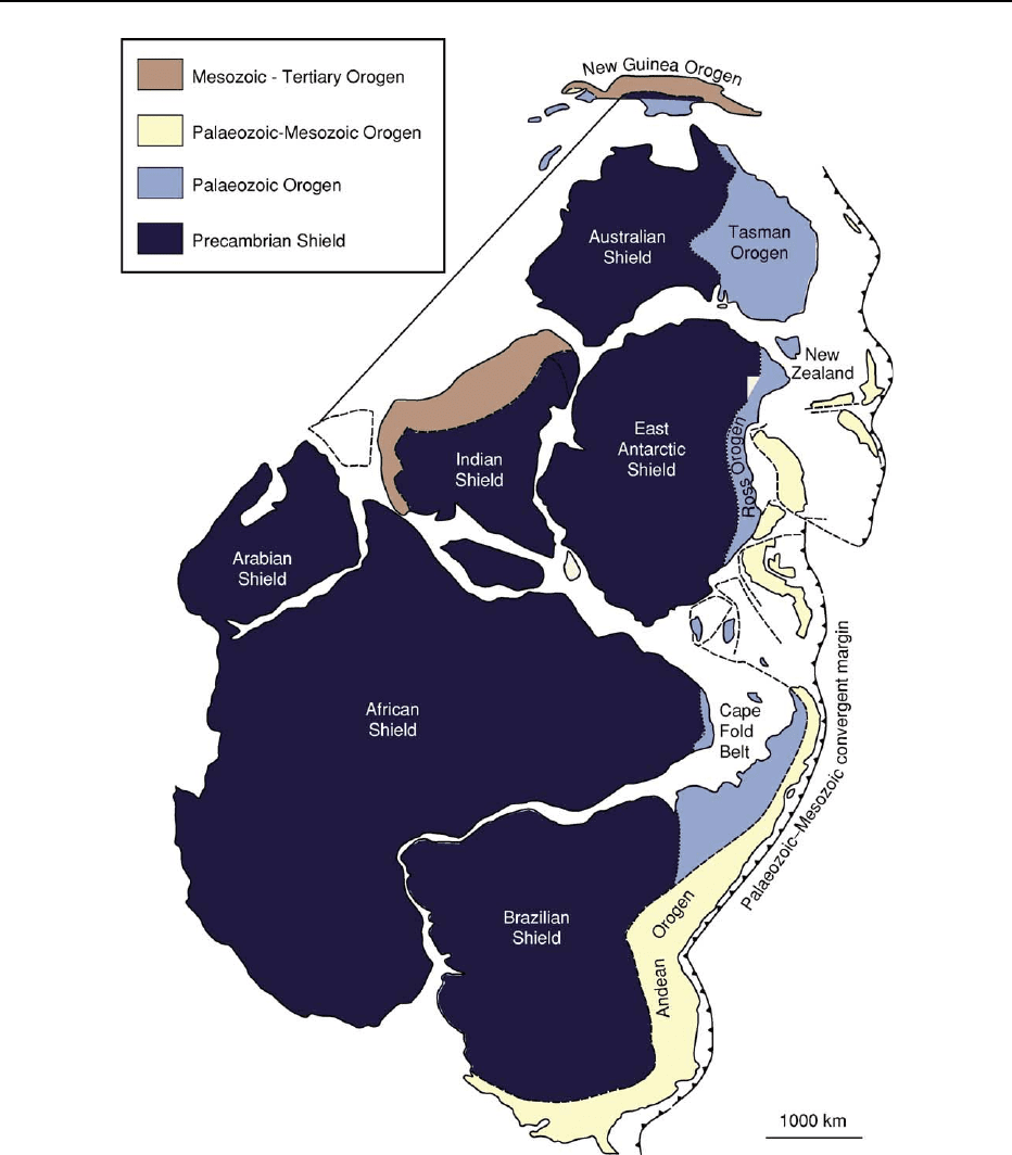
sequences (Figure 1). A region of eastern Australia
over 1000 km wide now consists of three distinct
orogenic belts (the Delamerian, Lachlan–Thomson,
and New England orogens), which are collectively
referred to as the Tasman Orogenic Belt (Figures 1
and 2). This deformed and metamorphosed tract of
rocks was once part of a major orogenic system that
extended some 20 000 km along the Gondwanan
margin, incorporating parts of the Andes in South
America (see Andes), the Cape Fold Belt in southern
Africa, and the Ross Orogen in Antarctica (see Ant-
arctic)(Figure 1). In eastern Australia accretion oc-
curred in a stepwise fashion, with an eastward
younging from the Cambrian to the Triassic, reflected
AUSTRALIA/Tasman Orogenic Belt 237
by peaks of deformation in the Early to Middle Cam-
brian, Late Ordovician–Silurian, and Permian–Trias-
sic in the respective orogenic belts (Table 1).
Crustal growth occurred largely by the addition of
turbidites (ocean-floor submarine-fan deposits),
cherts (ocean-basin deposits), mid-ocean ridge basalts
(oceanic crust), andesites (island arc), and granites.
These younger, largely Palaeozoic, rocks occur to
the east of the exposed Precambrian cratonic crystal-
line basement; the boundary between the two is
known as the Tasman Line (Figure 2). They represent
a significant addition (approximately 30% by surface
area) to the Australian continent whilst it was part of
Gondwana. Younger basinal sedimentary sequences
Figure 1 Simplified geological map of Gondwana with modern-day continental outlines, showing regions of Precambrian shield and
the younger orogenic belts. IGCP, Gondwana map base.
238 AUSTRALIA/Tasman Orogenic Belt
(e.g. Great Artesian, Murray, and Sydney–Bowen
Basins) now cover much of belt (Figure 3).
Accretion was accompanied by marked structural
thickening and shortening (by about 75%) of Neo-
proterozoic platform and rift basinal sequences (Dela-
merian part), a Cambrian–Orodovician composite
turbidite submarine fan overlying Cambrian oceanic
crust (Lachlan part), and Carboniferous–Permian arc,
fore-arc, and trench (subduction complex) and Per-
mian foreland basin sequences (New England part)
(Figure 3). For a large part of the history (Silurian–
Early Carboniferous), deformation occurred by mas-
sive telescoping, with thrusting largely directed away
from the cratonic core, together with components of
strike-slip translation within a progressively deform-
ing and prograding sediment fan along the Gondwa-
nan margin. The margin was intruded by voluminous
granitic plutons (accounting for up to 35% of the
area), derived from subduction-generated mantle
magmas and lower- to middle-crustal melting, be-
tween the Late Ordovician and the Triassic (Figure 3).
The spatial and temporal variations in deformation,
metamorphism, and magmatism across the Tasman
Orogenic Zone show how subduction–accretion
complexes are monotonous turbidite sequences
evolve through time and eventually form crust of
continental thickness and character.
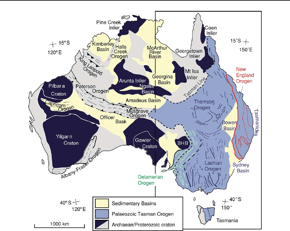
Tasman Orogen Make-up
The Delamerian, Lachlan–Thomson, and New Eng-
land Orogens, which form the composite Palaeozoic
and Mesozoic Tasman Orogen (Figure 2), are distin-
guished by their lithofacies (Figure 3), differing tec-
tonic settings, and timing of orogenesis and eventual
consolidation with the Australian craton (Table 1).
The Delamerian Orogen involved an inverted intra-
cratonic rift, the Lachlan Orogen involved closure of
a south-west-Pacific style marginal basin incorpor-
ating Bengal Fan-sized turbidite fans, and the New
England Orogen involved a deformed arc–subduction
complex belt.
Figure 2 The major geological elements of Australia, showing the Tasman Orogen along the eastern margin. Location of the more
detailed map area of Figure 3 is shown.
AUSTRALIA/Tasman Orogenic Belt 239

Delamerian Orogen
The Delamerian Orogen is the oldest and innermost
part, immediately adjacent to the Precambrian cra-
tonic core. The Delamerian Orogen was tectonically
active from the Late Precambrian (ca. 650–600 Ma) to
the Late Cambrian (ca. 500 Ma). It is now an arcuate
craton-verging thrust belt with foreland-style folds
and detachment-style thrusts. Duplexes in deformed
Cambrian deep-water sandstones and mudstones
(Kanmantoo Group) overlie less deformed and meta-
morphosed Neoproterozoic shelf sequences (Adelai-
dean). Metamorphic grade increases to the east, where
polyphase deformation and amphibolite-grade meta-
morphism with local development of kyanite–
sillimanite assemblages are spatially and temporally
confined to the aureoles of synkinematic granites that
are conformably aligned with the structural grain.
Lachlan Orogen
The Lachlan Orogen is the largest and the cen-
trally located orogenic belt (Figure 2) with a marked
similarity of sedimentary facies and structural style.
It was active from the Ordovician and has a com-
plex amalgamational and deformational history. The
western and central parts of the Lachlan Orogen are
dominated by a turbidite succession consisting of
quartz-rich sandstones and black shales. These are
laterally extensive over a present width of 800 km
and have a current thickness exceeding 10 km. The
eastern Lachlan Orogen consists of shoshonitic vol-
canics, volcaniclastic rocks, and limestone, as well as
quartz-rich turbidites and extensive black shales in
the easternmost part (Figure 3).
ThewesternLachlanOrogenconsistsofaneast-
wards-vergent thrust system with alternating zones
of north-westwards- and northwards-trending struc-
tures. The central Lachlan Orogen is dominated
by north-westwards-trending structures and consists
of a south-westwards-vergent thrust belt linked to a
fault-bounded metamorphic complex (Wagga-Omeo
Metamorphic Belt). The eastern Lachlan Orogen is
dominated by a northwards-trending structural grain
and eastwards-directed thrusting, which caused inver-
sion of extensional basins in the west. Tight-to-open
chevron folds (accommodating between 50% and 70%
shortening) cut by predominantly westwards-dipping
high-angle reverse faults are part of different thrust
systems within the Lachlan Orogen. The chevron
folds are upright and gently plunging, but become
Table 1 Orogens and subprovinces of the Tasman Orogenic Belt
Orogen Delamerian (West) Western Lachlan Central Eastern
New England
(East)
Main lithofacies Platform to deep-
water clastic
margin sequence
Quartz-rich turbidite
sequence on
oceanic crust
Quartz-rich turbidite
sequence on
oceanic crust
Platform carbonates
and clastics with
rhyolites and
dacitic tuffs
Volcanogenic
clastic
Initial setting Late Proterozoic
rifted margin
Cambro-Ordovician
submarine fan in
back-arc basin
Ordovician
submarine fan in
back-arc basin
Ordovician rifted
arc
Late
Palaeozoic
fore-arc–
arc–trench
Oldest lithology Basic volcanics Cambrian basic
volcanics
(
ca. 505 Ma)
Tremadocian chert Ordovician
andesitic
volcanics
(
ca. 485 Ma)
Ordovician
basic
volcanics
Main deformation Early to Middle
Cambrian
(
ca. 520–500 Ma)
Late Ordovician–
Silurian
(ca. 450–420 Ma)
Late Ordovician–
Early Devonian
(ca. 450–410 Ma)
Silurian–Early
Carboniferous
(ca. 430–360 Ma)
Late
Permian–
Triassic
(
ca. 265–
230 Ma)
Tectonic vergence Westwards-directed
thrusting
Eastwards-directed
thrusting
Overall strike-slip
(
ca. 410–400 Ma)
with south-
westwards-
directed thrusting
(
ca. 440–420 Ma)
Eastwards-directed
thrusting
Westwards-
directed
thrusting
Main plutonism Cambrian
(520–490 Ma)
Late Devonian
(380–360 Ma)
Late Silurian (ca.
430–400 Ma)
Late Silurian–
Devonian
(
ca. 430–380 Ma)
Late
Permian–
Triassic
(
ca. 270–
210 Ma)
240 AUSTRALIA/Tasman Orogenic Belt
