Elsevier Encyclopedia of Geology - vol I A-E
Подождите немного. Документ загружается.


continental sedimentary sections have increasingly
been incorporated in these calibrations. Work with
astronomically calibrated lacustrine sections of Trias-
sic–Jurassic age has demonstrated that older rocks
can also be anchored to the astronomical time-scale.
Dendrochronology
Methodology and Applications Dendrochronology
applies the nonsystematic, climate-dependent vari-
ations in the thickness of annual tree rings of particu-
lar tree species to determine very exact dates for
young events. Although restricted to use on Holocene
samples, the high precision of the method (trees pro-
duce one ring per year, and uncertainties in ages de-
termined with the method are usually 1 year) has
also been used to calibrate carbon-14 ages (see also
Table 3).
Future Considerations
Geochronology furnishes the temporal framework
for the study of geologic processes, giving data neces-
sary to evaluate the rates, quantity, and significance
of different rocks and geological ‘events’. Both rela-
tive and absolute ages are important in this regard
and should be viewed as complementary methods
through which different rock types may be corre-
lated in time. Today, a big challenge facing geochron-
ologists is the intercalibration of the various time-
scales. As part of this work, geologists working with
radiogenic isotopes are attempting to refine the decay
constants for a number of the commonly used radio-
genic isotope dating methods. Inaccurate decay con-
stants would clearly affect the accuracy of an age for a
rock determined with a particular isotope system, and
would have corresponding spin-off effects for ties
made to magnetostratigraphic, biostratigraphic, che-
mostratigraphic, and astronomically calibrated data-
sets. Intercalibration of the various time-scales back
through Mesozoic and Palaeozoic times will probably
incorporate all of these methods, with extension of
astronomical calibrations to the Palaeozoic probably
involving ‘floating’ astronomical time-scales interca-
librated with the continually updated and refined
GPTS and GTS.
Glossary
decay constant A number describing the probability
that a radioactive atom will decay in a unit time.
half-life The time required for half of a quantity of
radioactive atoms to decay.
isotopes Atoms with the same number of protons
(¼ the same element), but a different number of
neutrons (¼ different mass).
radioactive decay The spontaneous disintegration
of certain atoms whereby energy is emitted in
the form of radiation; a new, stable atom is the
result.
siderophile An element preferring a metallic phase,
with a weak affinity for oxygen or sulphur.
See Also
Analytical Methods: Fission Track Analysis. Conserva-
tion of Geological Specimens. Creationism. Earth: Or-
bital Variation (Including Milankovitch Cycles).
Dendrochronology. Famous Geologists: Cuvier;
Darwin; Hutton; Lyell; Murchison; Sedgwick; Smith; Steno.
Magnetostratigraphy. Mesozoic: End Cretaceous Extinc-
tions. Palaeomagnetism. Palaeozoic: Cambrian; End
Permian Extinctions. Plate Tectonics. Time Scale.
Further Reading
Butler RF (1992) Palaeomagnetism: Magnetic Domains
and Geologic Terranes. Cambridge, MA: Blackwell Sci-
entific Publications.
Cox A (ed.) (1973) Plate Tectonics and Geomagnetic Re-
versals. San Francisco, CA: WH Freeman and Company.
Dalrymple BG (1991) The Age of the Earth. Palo Alto, CA:
Stanford University Press.
Dickin AP (1995) Radiogenic Isotope Geology. Cambridge:
Cambridge University Press.
Doyle P, Bennett MR, and Baxter AN (1994) The Key
to Earth History: An Introduction to Stratigraphy.
Chichester: John Wiley and Sons.
Eicher DL (1976) Geologic Time, 2nd edn. Englewood
Cliffs, NJ: Prentice-Hall.
Eide EA (2002) Introduction – plate reconstructions and
integrated datasets. In: Eide EA (coord.) BATLAS – Mid
Norway Plate Reconstruction Atlas with Global and
Atlantic Perspectives, pp. 8–17. Trondheim: Geological
Survey of Norway.
Faure G (1986) Principles of Isotope Geology, 2nd edn.
New York: John Wiley and Sons.
Geyh MA and Schleicher H (1990) Absolute Age Determin-
ation: Physical and Chemical Dating Methods and Their
Application. Berlin: Springer-Verlag.
Hilgen FJ, Krijgsman W, Langereis CG, and Lourens LJ
(1997) Breakthrough made in dating of the geological
record. EOS 78(28): 285, 288–289.
Lewis C (2000) The Dating Game – One Man’s Search for
the Age of the Earth. Cambridge: Cambridge University
Press.
Renne PR, Deino AL, Walter RC, et al. (1994) Intercalibra-
tion of astronomical and radioisotopic time. Geology 22:
783–786.
ANALYTICAL METHODS/Geochronological Techniques 91

Gravity
J R Smallwood, Amerada Hess plc, London, UK
ß 2005, Elsevier Ltd. All Rights Reserved.
Introduction
The law of gravitational attraction between objects
was deduced by Isaac Newton in the late seventeenth
century. His ‘inverse square’ law stated that the force
attracting two objects was proportional to the masses
of the two objects and inversely proportional to the
square of the distance between them (Table 1). Since
the mass of the Earth is so great relative to the mass of
objects on its surface, attraction of objects towards
the Earth, i.e., their response to the Earth’s gravity
field, is often an important factor affecting geological
processes. Measurement of the gravity field of the
Earth is in itself a useful tool for investigating the
sub-surface, as mass variations below the surface
cause variations in the gravity field. The measurement
of the shape of the Earth and its mass distribution
have been important to defining the baseline gravity
field from which deviations can be measured, as usu-
ally the anomaly rather than the overall field strength
is useful for geological applications. There are now
many ways of acquiring gravity data on land, sea, air,
and from space, appropriate to the many scales on
which gravity studies can be applied. Gravity vari-
ations over thousands of kilometres can be used for
studies of mantle convection, variations over hun-
dreds and tens of kilometres are relevant for studies
such as lithospheric flexure, plate tectonics (see Plate
Tectonics), crustal structure, and sedimentary basin
development, hydrocarbon (see Petroleum Geology:
Exploration) and mineral exploration (see Mining
Geology: Exploration), while gravity variations over
tens of metres can be used in civil engineering
applications.
The Earth’s Shape and its Gravity Field
The gravitational potential of a perfectly uniform
sphere would be equal at all points on its surface.
However, the Earth is not a perfect sphere; it is an
oblate spheroid, and has a smaller radius at the
poles than at the equator. Surveys in the early eight-
eenth century, under the direction of Ch-M de La
Condamine and M de Maupertius found that a me-
ridian degree measured at Quito, Equador, near the
equator, was about 1500 m longer than a meridian
degree near Tornio, Finland, near the Arctic circle.
Subsequently, various standard reference spheroids or
ellipsoids have been proposed as first-order approxi-
mations to the shape of the Earth, such as the World
Geodetic System 1984 (Table 1). Given such an ellips-
oid, a gravity field can be calculated analytically as
a function of latitude. For example, a reference grav-
ity formula was adopted by the International As-
sociation of Geodesy in 1967 (IGF67, Table 1), and
another introduced in 1984 (WGS84, Table 1).
The mean density of the Earth, which is fundamen-
tal to the calculation of gravitational attraction, was
first estimated following an experiment in 1775 by
the Rev. Neville Maskelyne, using a technique sug-
gested by Newton. If the Earth was perfectly spherical
and of uniform density, then a plumbline would point
down towards the centre of the Earth because of the
force of gravity on the bob. However, any nearby
mass would deflect the plumbline off this ‘vertical’.
Maskelyne and his co-workers measured plumb-bob
deflections on the Scottish mountain, Schiehallion
(Figure 1). They discovered that the mountain’s gravi-
tational pull deflected the plumb line by 11.7 seconds
of arc. This allowed Charles Hutton to report in 1778
that the mean density of the Earth was approximately
4500 kg m
3
. This density value leads to an estimate
of the mass of the Earth of about 5 10
24
kg, not far
from the currently accepted value of 5.97 10
24
kg.
The Schiehallion experiment had another distinction,
in that in order to calculate the mass and centre of
gravity of the mountain a detailed survey was carried
out, and the contour map was invented by Hutton to
present the data.
Since the mass of the Earth is not distributed uni-
formly, the real gravity field does not correspond
to that calculated for an ellipsoid of uniform density.
The ‘geoid’ is a surface which is defined by points
of equal gravitational potential or equipotential
(Table 1), which is chosen to coincide, on average,
with mean sea-level. The geoid is not a perfect ellips-
oid, because local and regional mass anomalies per-
turb the gravitational potential surface in their vicinity
by several tens of metres. For example, a seamount on
the ocean floor, which is denser than the surrounding
seawater, will deflect the geoid downwards above it.
‘Geoid anomalies’ are defined as displacements of the
geoid above or below a selected ellipsoid. The concept
of the geoid as the global mean sea-level surface can be
extended across areas occupied by land. This provides
both a horizontal reference datum and a definition of
the direction of the vertical, as a plumbline will hang
perpendicular to the geoid.
92 ANALYTICAL METHODS/Gravity

Measurement of Gravity
The first measurements of Earth’s gravity, by timing the
sliding of objects down inclined planes, were made by
Galileo, after whom gravitational units were named.
1 Gal is 10
2
ms
2
, and the gravitational acceleration
at the Earth’s surface is about 981 Gal. For convenience
in geophysical studies of gravity anomalies, the mGal is
usually used, or for local surveys ‘gravity units’ (g.u.)
where 1 mGal ¼ 10 g.u. Gravity may be measured as an
absolute or relative quantity.
Classically, absolute gravity has been measured
with a pendulum consisting of a heavy weight sus-
pended by a thin fibre. The period of the oscilla-
tion is a function of gravitational acceleration and
the length of the pendulum. H Kater designed a
compound, or reverse, pendulum in 1815, that
allowed some instrument-dependent factors to be
cancelled out. The instrument was superceded by
methods based on observations of falling objects. In
a development of the free-fall method, a projectile is
Table 1 Gravity formulae
Quantity Formula Constants and variables
Gravitational Force
between two
masses, F
F ¼
GMm
r
2
G Gravitational or Newtonian constant,
6.67 10
11
m
3
kg
1
s
1
M Mass of body (Mass of earth approx. 5.97 10
24
kg)
m Mass of second body
r Distance
Gravitational
Acceleration, a
a ¼
GM
r
2
As above
Gravitational
Potential, V
V ¼
GM
r
As above
(Vertical) Gravity
anomaly
above a buried
sphere, dg
z
See Figure 6
dg
z
¼
4GDrb
3
h
3ðx
2
þ h
2
Þ
3=2
Dr Density contrast
b Radius of sphere
h Depth of sphere
x Horizontal distance
International Gravity
Formula 1967
g
t
¼ g
0
ð1 þ a sin
2
l þ b sin
4
lÞ g
0
Mean gravititational acceleration at equator,
9.7803185 ms
2
Gravitational
acceleration, g
t
a 5.278895 10
3
b 2.3462 10
5
l Latitude
WGS84 Ellipsoidal
Gravity Formula
g
t
¼
g
0
ð1 þ d sin
2
lÞ
ffiffiffiffiffiffiffiffiffiffiffiffiffiffiffiffiffiffiffiffiffiffiffiffiffiffiffiffiffi
ð1 e sin
2
l
q
Þ
g
0
Mean gravititational acceleration at equator,
9.7803267714 ms
2
Gravitational
acceleration, g
t
d 1.93185138639 10
3
e 6.6943999103 10
3
l Latitude
WGS Formula
atmospheric
correction, dg
t
dg
t
¼ 0:87 10
5
expð0:116h
1:047
Þ
h Elevation
Latitude
correction for
relative gravity
measurements, dg
L
dg
L
¼ 8:12 10
5
sin2 l dl
dl Distance in N–S direction between readings
l Latitude
Bouguer plate
correction, dg
B
dg
B
¼ 2pr Gh
r Bouguer correction density
h Elevation
Free air correction,
dg
FA
dg
FA
¼ 308:6 h
h Elevation
Free air anomaly, g
FA
g
FA
¼ g
obs
g
t
þðdg
L
þ dg
FA
Þ
g
obs
Observed gravity
Bouguer anomaly, g
B
g
B
¼ g
obs
g
t
þðdg
L
þ dg
FA
dg
B
þ dg
T
Þ
dg
T
Terrain correction
Flattening factor for
ellipsoid, f
f ¼
a c
c
¼
1
298:26
a Equatorial radius of Earth, 6378.14 km
c Polar radius of Earth, 6356.75 km
ANALYTICAL METHODS/Gravity 93
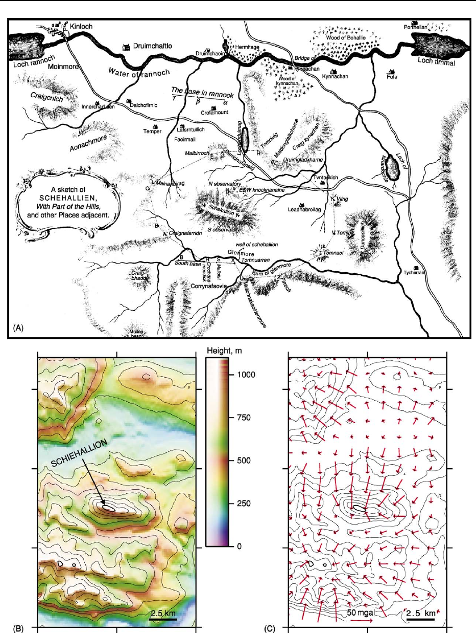
Figure 1 Sketch map of the area around Schiehallion, Scotland, by Charles Hutton. Plumb-line deflections measured at stations
north and south of the mountain allowed the first estimate of the density of the earth. (After R.M. Sillito with permission from Hutton
(1778) ß The Royal Society.)
94 ANALYTICAL METHODS/Gravity

fired vertically upwards and allowed to fall back
along the same path. The gravity measurement
depends on timing the upward and downward paths,
which may be by light beam-controlled timers or
interferometry.
Gravity differences can be measured on land with a
stable gravity meter or gravimeter based on Hooke’s
law. A mass extends a spring under the influence of
gravity and changes in extension are proportional to
changes in the gravitational acceleration. More sensi-
tive are ‘astatic’ gravity meters, which contain a mass
supported by a ‘zero-length’ spring for which tension
is proportional to extension. When the meter is in
position, a measurement is made of an additional
force needed to restore the mass to a standard pos-
ition, supplied by an auxiliary spring or springs, an
electrostatic system, or an adjustment of the zero-
length spring itself. Gravity meters working on this
principle measure differences in gravity between sta-
tions and surveys may be tied to one or more base
stations at which repeated measurement can be made.
Astatic gravity meters can have a sensitivity of about
0.01 mGal.
For applications where the gravity meter is sub-
ject to tilting and vibration, such as on board a ship
or in an aircraft, isolation of the instrument is re-
quired such as providing a moving stabilised plat-
form for the gravity meter and damping vibrations
with appropriate shock absorption. When the gravity
meter is moving, accurate data on the location and
trajectory of the platform is required along with
the gravity measurement. For airborne application,
this requirement has been greatly assisted by the
advent of the global positioning system (GPS) which
allows rapid, precise, and accurate positioning (see
Remote Sensing: GIS). Airborne gravity surveys,
whether flown using fixed wing or helicopters, can
provide economic, rapid, and non-invasive geophys-
ical reconnaissance ideal for difficult terrain such as
tundra, jungles, and wildlife reserves.
Deviations in artificial satellite orbits can be used
to determine the long-wavelength components of the
Earth’s gravity field. Altimetry tools mounted on sat-
ellites have allowed much more detailed gravity map-
ping over the oceans, as sea surface height data can
be processed to give the marine geoid. Geoid data
can then be converted to gravity data with a series
of numerical operations (Figure 2). Since the mean
sea-level surface is the geoid, an equipotential surface,
variations in sea surface height from the reference
ellipsoid reflect density changes below the sea surface,
largely from the density contrast at the seabed,
but also from sub-seabed changes, such as crustal
thickness changes.
Adjustments to Measured
Gravity Signals
The first correction that can be applied to measured
gravity values is the correction for latitude, to account
for the centrifugal acceleration which is maximum
at the equator and zero at the poles (Table 1). For
gravity measurements made on land, several further
corrections must be made (Table 1). The ‘free-air cor-
rection’ is made to adjust for difference in height be-
tween the measurement point and sea-level. This does
not make any assumptions about the material between
the sea-level datum level and the observation point and
uses the inverse square law and the assumption of a
spherical Earth. The ‘Bouguer correction’, named after
the French mathematician and astronomer, is used to
account for the gravitational effect of the mass of ma-
terial between measurement point and sea-level. This
requires assumptions to be made about the density of
material, and the Bouguer plate or slab formula is
applied (Table 1), which further assumes that this ma-
terial is a uniform infinite plate. Historically a ‘density
correction’ value of 2670 kg m
3
has been used as a
standard density for crustal material, and this corres-
ponds to a Bouguer correction of 1.112 g.u./m, nega-
tive above sea-level. A ‘terrain correction’ may be
applied to compensate for the effect of topography,
again requiring assumptions about densities. Nearby
mass above the gravity measurement station will de-
crease the reading and any nearby topographic lows
will have been be artificially ‘filled in’ by the Bouguer
correction so the correction is always positive. An add-
itional correction to gravity measurements made on a
moving vehicle such as an aeroplane or boat is the
Eo
¨
tvo
¨
s correction, which depends on horizontal speed
vector, latitude, and flight altitude.
Gravity Anomalies and Derivatives
Since for most geological applications the perturb-
ations in the gravity field across an area or feature
of interest are more important than the absolute grav-
ity values, it is standard to compute gravity anomalies
by subtracting the theoretical gravity value from the
observed. The Bouguer gravity anomaly is the ob-
served value of gravity minus the theoretical gravity
value for a particular latitude and altitude, as outlined
in Table 1. The Bouguer gravity is commonly used on
land where maps of gravity anomalies can be used to
view gravity data in plane view and it is convenient to
have topographic effects (approximately) removed.
Offshore, the free-air gravity anomaly is most useful,
as the measurements are straightforward to correct to
the sea-level datum.
ANALYTICAL METHODS/Gravity 95
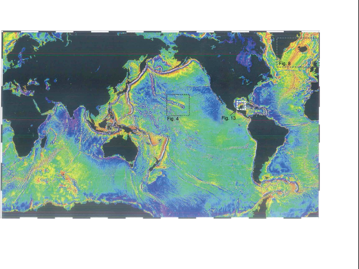
Figure 2 Marine free-air gravity anomaly map derived from satellite altimetry (Sandwell and Smith (1997)). Warm colours indicate positive gravity anomalies. The gravity anomaly
primarily indicates the shape of the seafloor, due to the strong density contrast from seawater to oceanic crust. Oceanic island chains, subduction zone trenches, and mid-ocean ridges form
features visible on this world map. Locations of Figures 4, 8 and 13 indicated. (Image courtesy of NGDC.)
96 ANALYTICAL METHODS/Gravity
High-pass filtering or subtraction of a planar func-
tion from gravity anomaly data may be undertaken to
remove a ‘residual’ or background trend if the feature
of interest is known to be shallow or a subtle perturb-
ation to a strong regional gradient. Other treatments
of gravity data include upward and downward con-
tinuation, by which different observation levels can
be simulated, and computation of vertical or hori-
zontal derivatives, which may emphasise structural
trends in the data.
Applications and Examples
Submarine Topography
The satellite-derived free-air gravity anomaly map over
the oceans (Figure 2)stronglyreflectsthenearest
significant density change, the seabed. There are posi-
tive gravity anomalies over seabed topographic highs
such as submarine seamounts and mid-ocean ridges
and negative anomalies over bathymetric deeps such
as the trenches associated with subduction zones,
although long-wavelength isostatically compensated
structures have no gravity anomaly above them.
The coverage of the marine free-air gravity anomaly
data can be exploited to produce sea-floor topography
data (Figure 2). For this purpose, shipboard depth
surveys, usually made with sonar equipment, are used
to supply the long-wavelength part of the transfer func-
tion from gravity to topography. The shipboard data
is usually considered accurate but limited in global
coverage due to the spacing and orientation of
survey ship tracks. Bathymetry interpolation using the
satellite-derived gravity data highlights isostatically
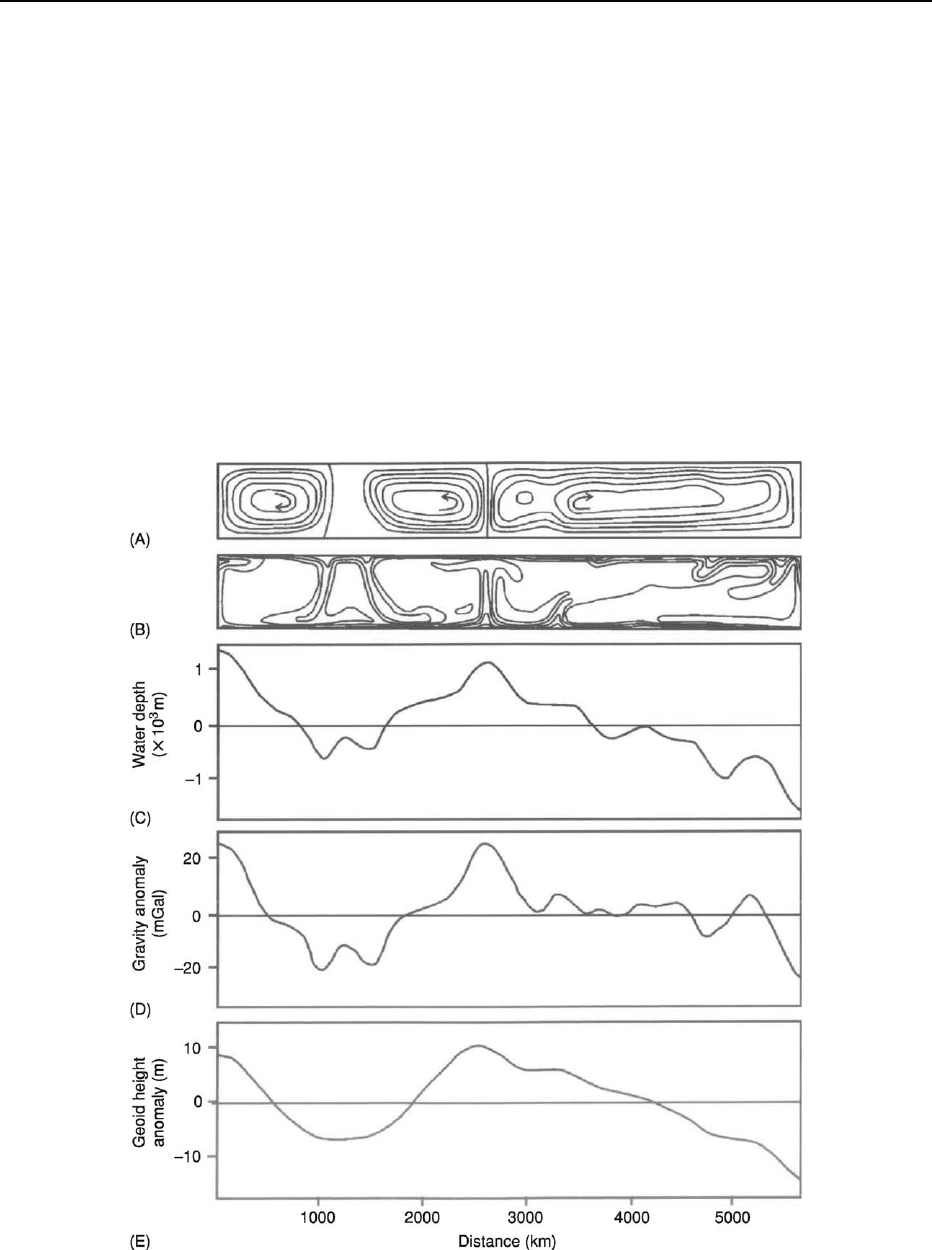
Figure 3 Model of the gravity effect of convection in the Earth’s mantle. (A) Stream function of computer modelled mantle flow
(B) 100
C temperature contours (C) Variation in seafloor depth given a 30 km-thick elastic lithosphere above the convecting mantle
(D) Modelled free-air gravity anomaly (E) Modelled geoid (sea-surface height) anomaly over the convecting mantle. (Reproduced with
kind permission from McKenzie et al. (1980) ß Nature Publishing Group. http:www.nature.com)
ANALYTICAL METHODS/Gravity 97
compensated topography which has no long-wave-
length expression in the gravity data alone.
Mantle Convection
It is commonly accepted that the Earth’s mantle con-
vects, and the flow of mantle material gives rise to
gravity anomalies. Where mantle material is anomal-
ously hot, it has a lower density than surrounding
cooler mantle, and it will give rise to a negative grav-
ity anomaly at the surface. This effect is, however,
overprinted by the positive gravity anomaly caused
by the upward deflection of the lithosphere above the
rising anomalously hot mantle column or sheet (see
Mantle Plumes and Hot Spots). There will, therefore,
be a positive gravity anomaly over rising mantle ma-
terial and a negative gravity anomaly where mantle is
cool and sinking (Figure 3).
Isostasy and Lithospheric Strength
Not all mountains would cause a gravitational plumb-
line deflection such as that observed at Schiehallion.
Bouguer had observed that a plumb-line was only de-
flected by 8 seconds of arc towards the mountains
during Condamine’s Quito survey, while his calcula-
tions suggested that it should have been deflected as
much as 1
0
43
00
. This anomalous lack of deflection was
attributed by R. Boscovich in 1755 to ‘compensation’
for the mass excess of the mountain by underlying mass
deficiency at depth. This fed into the development of
‘isostasy’, which addresses the issue of support for
topography on the Earth’s surface. Two alternative
early views of isostatic theory were put forward in the
1850s. John Henry Pratt suggested that the amount of
matter in a vertical column from the surface to some
reference level in the Earth was always equal, and that
this was achieved by the material in the column having
lower density material below mountains than below
topographic lows. George Biddell Airy advanced the
alternative view using the analogy of icebergs, that
elevated surface topography was underlain by low-
density crustal roots which effectively displaced denser
underlying material. Subsequent studies have used
gravity data to investigate these alternative models in
different tectonic settings and included the additional
factor of the strength of the lithosphere to support
loads.
At wavelengths shorter than about 500 km, the rela-
tionship between the gravity anomaly and topography
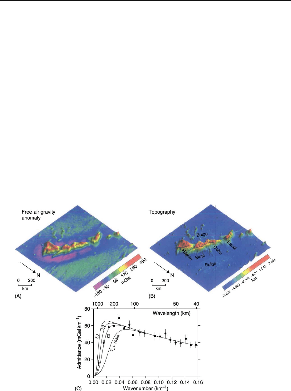
Figure 4 Free-air gravity anomaly (A) and topography (B) in the region of the Hawaiian islands, Pacific Ocean (see Figure 2 for
location). (C) A comparison of the observed admittance along the Hawaiian-Emperor seamount chain (dots) with the predictions of a
simple flexure model of isostasy, with varying elastic thickness, Te (lines). The observed admittance can be best explained with an
elastic thickness for the lithosphere of 20–30 km. See Watts (2001) for more details. (Reproduced with kind permission from Watts
(2001) ß Cambridge University Press.)
98 ANALYTICAL METHODS/Gravity
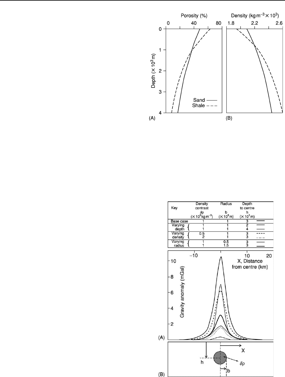
Figure 6 Modelled gravity anomaly (A) along a transect
through the centre of a buried sphere (B) of varying radius
b, density contrast dr, and depth of burial h. The similarity in
shape between the various cases shown highlights the difficulties
of interpretation of gravity anomalies, as there are no unique
solutions to explain a particular gravity anomaly.
Figure 5 Typical variation of (A) porosity and (B) density with
depth below seafloor for sands and shales in a sedimentary
basin. Increasing vertical effective stress with depth causes com-
paction of the rock, reducing porosity and correspondingly in-
creasing density. Deeply buried sedimentary rocks, therefore,
have higher densities than shallower rocks of similar lithology.
is controlled by the mechanical properties of the litho-
sphere, which may be strong enough to support short
wavelength loads, for example, isolated mountains. At
longer wavelengths, the flexural strength of the litho-
sphere is commonly insufficient to support loads. The
relationship between the gravity anomaly and topog-
raphy can described by the wavelength-dependent
‘admittance’ function. The rate of change from flexu-
rally-supported topography at short wavelength to
topographic support by base-lithospheric pressure vari-
ations and regional density variation at long-wave-
length depends on the effective ‘elastic thickness’ of
the lithosphere.
Figure 4 shows the topography and gravity anom-
aly of some of the Hawaiian island chain and the
calculated admittance. For these islands, a modelled
elastic thickness of about 25 km matches the admit-
tance data. Recently, methods have been developed to
also include the effect of lithospheric loads both with
and without topographic expression in estimation of
the elastic thickness.
Density Contrasts, Analytical Models, and
Non-Uniqueness
On a smaller scale, gravity anomaly maps provide the
opportunity to identify and delineate sub-surface struc-
tures, as long as there are lateral density changes asso-
ciated with the structure. Rocks at and near the surface
of the Earth are much less dense than the Earth’saver-
age density of approximately 5155 kg m
3
, and crustal
rocks are almost universally less dense than mantle
rocks. An approximate density value of 2670 kg m
3
is often taken as an average value for upper crustal
rocks while values of 2850 kg m
3
and 3300 kg m
3
have been used for overall crustal rocks and uppermost
mantle, respectively, although these values vary with
composition and temperature. Many sedimentary
rocks are less dense than metamorphic and igneous
rocks. Coal (1200–1500 kg m
3
) is one of the least
dense rocks, while chalks and siliciclastic sedimentary
rocks (1900–2100 kg m
3
) are generally less dense than
massive carbonates (2600–2700 kg m
3
). With the ex-
ception of porous extrusive examples, crustal igneous
rocks have densities approximately ranging from 2700
to 3000 kg m
3
. Density is not a diagnostic for lith-
ology and variation in parameters such as porosity,
temperature, and mineralogy can give significant dens-
ity variability. Rocks with the lowest densities are those
with very high porosities such as volcanic pumice, and
in sub-aqueous environments recently deposited sedi-
ments. Density of sediments in a sedimentary basin
tends to increase with depth as grains are compacted
together (Figure 5). Igneous and metamorphic rocks
tend to have higher densities than sediments as they
frequently have negligible porosity and consist of
relatively dense minerals.
ANALYTICAL METHODS/Gravity 99
Any non-uniformity in mass distribution results
in lateral variability of the gravity field. For some
simple geometrical shapes, a gravity anomaly can
be calculated analytically (Figure 6). The buried
sphere example illustrates the observation that deep
density anomalies give rise to an anomaly over a
wider surface distance than otherwise similar shallow
anomalies, while greater density contrasts give larger
anomalies than small density contrasts. The similarity
in the gravity anomaly curves for the example of a
buried sphere (Figure 6) illustrates one of the prob-
lems that arises in interpreting gravity data: there is
no unique density distribution that produces a par-
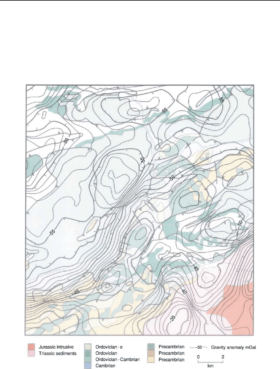
ticular gravity anomaly. Gravity models tend to be
constructed using additional geological or geophys-
ical data such as seismic refraction or reflection
profiles, surface geology (Figure 7), borehole dens-
ity measurements, magnetic, magneto-telluric, or
Figure 7 Bouguer gravity anomaly contours overlain on geological map of part of Eastern Pennsylvania, USA. Bouguer gravity
anomaly highs occur over the horst blocks of dense Precambrian material and other lows and highs in the gravity field are associated
with formations of varying densities. (Geological map courtesy of the Bureau of Topographic and Geologic Survey, Pennsyvania
Department of Conservation and Natural Resources, gravity data courtesy of W. Gumert and Carson Services Inc. Aerogravity
Division, PA, USA.)
100 ANALYTICAL METHODS/Gravity
