El-Rabbany A. Introduction to GPS
Подождите немного. Документ загружается.


recently, paper charts were the only source of information available to
mariners. However, over a decade ago, the Electronic Chart Display and
Information System (ECDIS) was introduced, revolutionizing the field of
marine navigation.
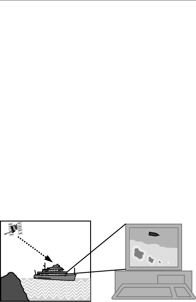
ECDIS is a computerized navigation system that integrates geographic
information with navigation instrumentation [10]. It consists mainly of a
computer processor and display, a digital database, and navigation sensors
(see Figure 4.13). ECDIS is not only capable of displaying the navigation-
related information in real time but also supporting other advanced func-
tions [11]. For example, rout planning, rout monitoring, and automatic
alarms, to name a few, are all supported by ECDIS. ECDIS and
Radar/Automatic Radar Plotting Aid (ARPA) may be superimposed on a
single display to provide a system that can be used for collision avoidance
as well. The International Maritime Organization (IMO) adopted the per-
formance standards for ECDIS in November 1995. The standards specify,
among other things, that two independent positioning sources are
required for ECDIS [10].
A number of hydrographic offices are currently involved in producing
ECDIS databases by digitizing existing paper charts (i.e., converting paper
charts into digital computer files). However, this has the disadvantage that
the paper charts are generally based on local datums. This means that cor-
rect datum shifts must be considered to ensure consistency [11]. In addi-
tion, the paper charts in some areas were based on old survey methods,
which are far less accurate than the required standards. A complete resur-
vey of those areas might be required to overcome this problem.
Datums, Coordinate Systems, and Map Projections 63
Figure 4.13 Marine nautical chart system.
TEAMFLY
Team-Fly
®

4.7 Local arbitrary mapping systems
When surveying small areas, it is often more appropriate to employ a user-
defined local plane coordinate system. In this case, the curved Earths
surface may be considered as a plane surface with a negligible amount of
distortion. To establish a local coordinate system with GPS, a set of points
with known coordinate values in both the WGS 84 and the local system
must be available [5].
By comparing the coordinates of the common points (i.e., points with
known coordinates in both the local system and the WGS 84 system), the
transformation parameters may be obtained using the least squares tech-
nique. These transformation parameters will be used to transform all the
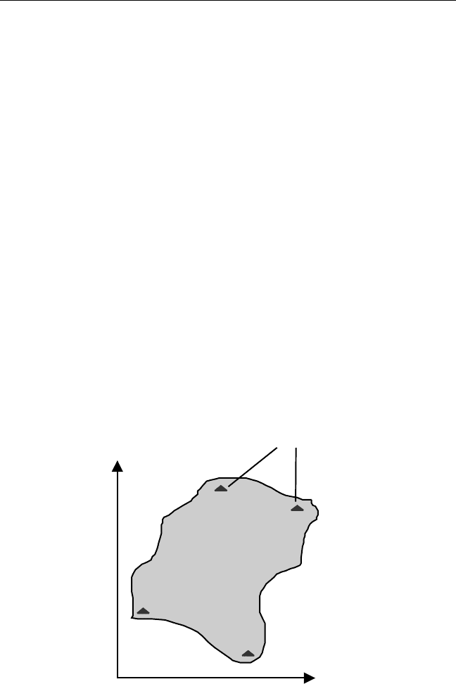
new GPS-derived coordinates into the local coordinate system. It should be
noted that the better the distribution of the common points, the better the
solution (see Figure 4.14). The number of common points also plays an
important role. The greater the number of common points, the better the
solution [2].
Establishing a local coordinate system is usually done in either of
two ways. One way is to supply the transformation parameters software
64 Introduction to GPS
Easting
Northing
Control
points
Project
area
Figure 4.14 Local arbitrary mapping system.

(usually provided by the manufacturers of the GPS receivers) with the
coordinates of the common points in both systems, if they are available.
The software will then compute the transformation parameters, which
once downloaded into the GPS data collector will be used to automatically
transform all the new coordinates into the local coordinate system. Alter-
natively, if the coordinates of a set of points are known only in the local
coordinate system, the user may occupy those points with the rover
receiver to obtain their coordinates in the WGS 84 system. Real-time kine-
matic (RTK) GPS surveying (see Chapter 5) is normally used for this pur-
pose. This allows the determination of the transformation parameters
while in the field.
4.8 Height systems
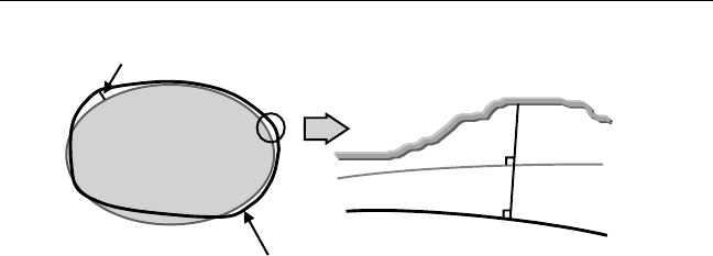
The height (or elevation) of a point is defined as the vertical distance from
the vertical datum to the point (Figure 4.15). As stated in Section 4.1, the
geoid is often selected to be the vertical datum [2]. The height of a point
above the geoid is known as the orthometric height. It can be positive or
negative depending on whether the point is located above or below the
geoid. Because they are physically meaningful, orthometric heights are
often needed in practice and are usually found plotted on topographic
maps [2].
In some cases, such as the case of GPS, the obtained heights are referred
to the reference ellipsoid, not the geoid (Figure 4.15). Therefore, these
heights are known as the ellipsoidal heights. An ellipsoidal height can also
be positive or negative depending on whether the point is located above or
below the surface of the reference ellipsoid. Unfortunately, ellipsoidal
heights are purely geometrical and do not have any physical meaning. As
such, the various Geomatics instruments (e.g., the total stations) cannot
directly sense them.
The geoid-ellipsoid separation is known as the geoidal height or undu-
lation (Figure 4.15). This distance can reach up to about 100m, and it can
be positive or negative depending on whether the geoid is above or below
the reference ellipsoid at a particular point [12]. Accurate information
about the geoidal height leads to the determination of the orthometric
height through the ellipsoidal height, and vice versa. Geoid models that
describe the geoidal heights for the whole world have been developed.
Datums, Coordinate Systems, and Map Projections 65

Unfortunately, these models do not have consistent accuracy levels every-
where, mainly because of the lack of local gravity data and the associated
height information in some parts of the world [12]. Many GPS receivers
and software packages have built-in geoid models for automatic conver-
sion between orthometric and ellipsoidal heights. However, care must be
taken when applying them, as they are usually low-accuracy models.
References
[1] Torge, W., Geodesy, New York: Walter de Gruyter, 1991.
[2] Vanicek, P., and E. J. Krakiwsky, Geodesy: The Concepts, 2nd ed., New
York: North Holland, 1986.
[3] Leick, A., GPS Satellite Surveying, 2nd ed., New York: Wiley, 1995.
[4] National Geodetic Survey, Geodetic Glossary, U.S. Department of
Commerce, NOAA, Rockville, MD: U.S. Department of Commerce,
NOAA, 1986.
[5] Hoffmann-Wellenhof, B., H. Lichtenegger, and J. Collins, Global
Positioning System: Theory and Practice, 3rd ed., New York:
Springer-Verlag, 1994.
[6] Boucher, C., and Z. Altamimi, International Terrestrial Reference
Frame, GPS World, Vol. 7, No. 9, September 1996, pp. 7174.
[7] Malys, S., et al., Refinements to the World Geodetic System 1984, Proc.
ION GPS-97, 10th Intl. Technical Meeting, Satellite Division, Institute of
Navigation, Kansas City, MO, September 1619, 1997, pp. 841850.
[8] Craymer, M., R. Ferland, and R. Snay, Realization and Unification of
NAD83 in Canada and the U.S. Via the ITRF, Proc. Intl. Symp. Intl. Assoc.
66 Introduction to GPS
N
Geoid
Best-fitting
ellipsoid
N
H
h
Terrain
Geoid
Ellipsoid
Figure 4.15 Height systems.

of Geodesy, Sec. 2, Towards an Integrated Geodetic Observing System
(IGGOS), Munich, Germany, October 59, 1998.
[9] Krakiwsky, E. J., Conformal Map Projections in Geodesy, Department of
Geodesy and Geomatics Engineering, L.N. No. 37, University of New
Brunswick, Fredericton, New Brunswick, Canada, 1973.
[10] Alexander, L., What Is an ENC? Hydro International,Vol.2,No.5,
July/August 1998, pp. 6063.
[11] Casey, M. J., and P. Kielland, Electronic Charts and GPS, GPS World,
Vol. 1, No. 4, July/August 1990, pp. 5659.
[12] Schwarz, K. P., and M. G. Sideris, Heights and GPS, GPS World,Vol.4,
No. 2, February 1993, pp. 5056.
Datums, Coordinate Systems, and Map Projections 67

5
GPS Positioning Modes
Positioning with GPS can be performed by either of two ways: point posi-
tioning or relative positioning. GPS point positioning employs one GPS
receiver that measures the code pseudoranges to determine the users posi-
tion instantaneously, as long as four or more satellites are visible at the
receiver. The expected horizontal positioning accuracy from the civilian
C/A-code receivers has gone down from about 100m (2 drms) when selec-
tive availability was on, to about 22m (2 drms) in the absence of selective
availability [1]. GPS point positioning is used mainly when a relatively
low accuracy is required. This includes recreation applications and low-
accuracy navigation.
GPS relative positioning, however, employs two GPS receivers simul-
taneously tracking the same satellites. If both receivers track at least four
common satellites, a positioning accuracy level of the order of a subcenti-
meter to a few meters can be obtained [2]. Carrier-phase or/and pseu-
dorange measurements can be used in GPS relative positioning, depending
on the accuracy requirements. The former provides the highest possible
accuracy. GPS relative positioning can be made in either real-time or post-
mission modes. GPS relative positioning is used for high-accuracy applica-
tions such as surveying and mapping, GIS, and precise navigation.
69

5.1 GPS point positioning
GPS point positioning, also known as standalone or autonomous position-
ing, involves only one GPS receiver. That is, one GPS receiver simultane-
ously tracks four or more GPS satellites to determine its own coordinates
with respect to the center of the Earth (Figure 5.1). Almost all of the GPS
receivers currently available on the market are capable of displaying their
point-positioning coordinates.
To determine the receivers point position at any time, the satellite
coordinates as well as a minimum of four ranges to four satellites are
required [2]. The receiver gets the satellite coordinates through the naviga-
tion message, while the ranges are obtained from either the C/A-code or
the P(Y)-code, depending on the receiver type (civilian or military). As
mentioned before, the measured pseudoranges are contaminated by both
the satellite and receiver clock synchronization errors. Correcting the satel-
lite clock errors may be done by applying the satellite clock correction in
the navigation message; the receiver clock error is treated as an additional
unknown parameter in the estimation process [2]. This brings the total
number of unknown parameters to four: three for the receiver coordinates
and one for the receiver clock error. This is the reason why at least four sat-
ellites are needed. It should be pointed out that if more than four satellites
are tracked, the so-called least-squares estimation or Kalman filtering tech-
nique is applied [24]. As the satellite coordinates are given in the WGS 84
system, the obtained receiver coordinates will be in the WGS 84 system as
70 Introduction to GPS
Known: X, Y, Z (satellites)
+R
1
,R
2
,R
3
,R
4
Unknown: X, Y, Z (receiver)
+ receiver clock error
Horizontal accuracy: 22m (95% of the time)
R
4
R
3
R
2
R
1
Figure 5.1 Principle of GPS point positioning.

well, as explained in Chapter 4. However, most GPS receivers provide the
transformation parameters between WGS 84 and many local datums used
around the world.
5.2 GPS relative positioning
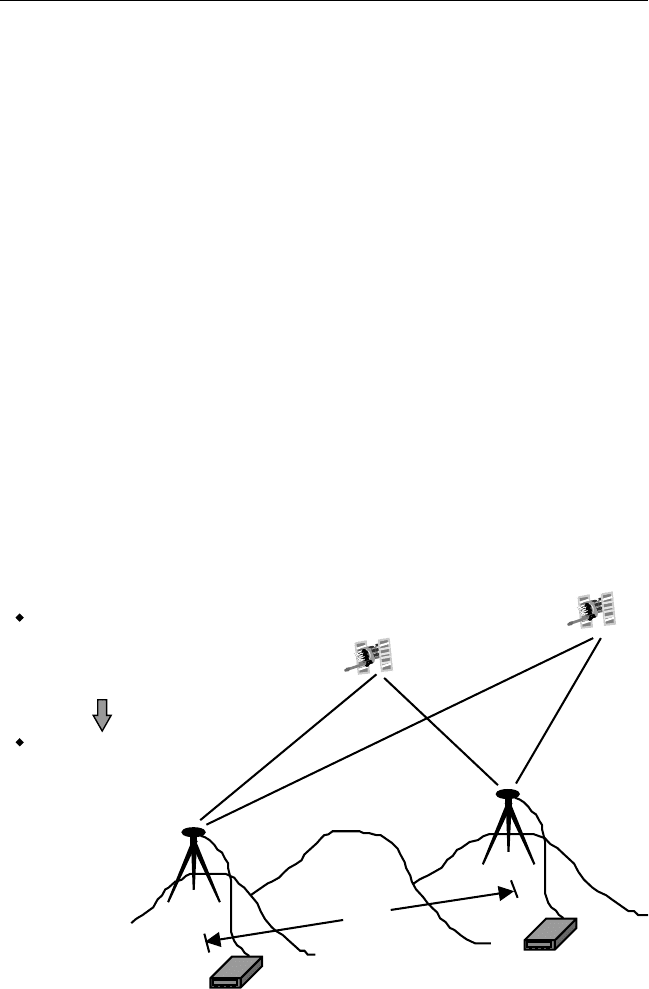
GPS relative positioning, also called differential positioning, employs two
GPS receivers simultaneously tracking the same satellites to determine
their relative coordinates (Figure 5.2). Of the two receivers, one is selected
as a reference, or base, which remains stationary at a site with precisely
known coordinates. The other receiver, known as the rover or remote
receiver, has its coordinates unknown. The rover receiver may or may not
be stationary, depending on the type of the GPS operation.
A minimum of four common satellites is required for relative position-
ing. However, tracking more than four common satellites simultaneously
would improve the precision of the GPS position solution [2]. Carrier-
phase and/or pseudorange measurements can be used in relative posi-
tioning. A variety of positioning techniques are used to provide a
GPS Positioning Modes 71
Known: X, Y, Z (satellites)
+ R,R,R,R
1234
+ X, Y, Z (base)
Unknown: X, Y, Z
(remote)
R
1
R
2
R
3
R
4
D
Figure 5.2 Principle of GPS relative positioning.

postprocessing (postmission) or real-time solution. Details of the com-
monly used relative positioning techniques are given in Sections 5.3 to 5.7.
GPS relative positioning provides a higher accuracy than that of autono-
mous positioning. Depending on whether the carrier-phase or the pseu-
dorange measurements are used in relative positioning, an accuracy level of
a subcentimeter to a few meters can be obtained. This is mainly because the
measurements of two (or more) receivers simultaneously tracking a par-
ticular satellite contain more or less the same errors and biases [5]. The
shorter the distance between the two receivers, the more similar the errors.
Therefore, if we take the difference between the measurements of the two
receivers (hence the name differential positioning), the similar errors
will be removed or reduced.
5.3 Static GPS surveying
Static GPS surveying is a relative positioning technique that depends on the
carrier-phase measurements [2]. It employs two (or more) stationary
receivers simultaneously tracking the same satellites (see Figure 5.3). One
receiver, the base receiver, is set up over a point with precisely known coor-
dinates such as a survey monument (sometimes referred to as the known
point). The other receiver, the remote receiver, is set up over a point whose
coordinates are sought (sometimes referred to as the unknown point). The
base receiver can support any number of remote receivers, as long as a
minimum of four common satellites is visible at both the base and the
remote sites.
In principle, this method is based on collecting simultaneous measure-
ments at both the base and remote receivers for a certain period of time,
which, after processing, yield the coordinates of the unknown point. The
observation, or occupation, time varies from about 20 minutes to a few
hours, depending on the distance between the base and the remote receiv-
ers (i.e., the baseline length), the number of visible satellites, and the satel-
lite geometry. The measurements are usually taken at a recording interval
of 15 or 20 seconds, or one sample measurement every 15 or 20 seconds.
After completing the field measurements, the collected data is down-
loaded from the receivers into the PC for processing. Different processing
options may be selected depending on the user requirements, the baseline
length, and other factors. For example, if the baseline is relatively short, say,
72 Introduction to GPS
