El-Rabbany A. Introduction to GPS
Подождите немного. Документ загружается.


4.3 What coordinates are obtained with GPS?
The satellite coordinates as given in the broadcast ephemeris will refer to
the WGS 84 reference system. Therefore, a GPS user who employs the
broadcast ephemeris in the adjustment process will obtain his or her coor-
dinates in the WGS 84 system as well. However, if a user employs the pre-
cise ephemeris obtained from the IGS service (Chapter 7), his or her
solution will be referred to the ITRF reference system. Some agencies pro-
vide the precise ephemeris in various formats. For example, Geomatics
Canada provides its precise ephemeris data in both the ITRF and the NAD
83 (CSRS) formats.
The question that may arise is what happens if the available reference
(base) station coordinates are in NAD 83 rather than in WGS 84?
The answer to this question varies, depending on whether the old or the
improved NAD 83 system is used. Although the sizes and shapes of the ref-
erence ellipsoids of the WGS 84 and the old NAD 83 are almost identical;
their origins are shifted by more than 2m with respect to each other [3].
This shift causes a discrepancy in the absolute coordinates of points when
expressed in both reference systems. In other words, a point on the Earths
surface will have WGS 84 coordinates that are different from its coordi-
nates in the old NAD 83. The largest coordinate difference is in the height
component (about 0.5m). However, the effect of this shift on the relative
GPS positioning is negligible. For example, if a user applies the NAD 83
coordinates for the reference station instead of its WGS 84, his or her solu-
tion will be in the NAD 83 reference system with a negligible error (typi-
cally at the millimeter level). The improved WGS 84 and the NAD 83
systems are compatible.
4.4 Datum transformations
As stated in Section 4.1, in the past, positions with respect to horizontal and
vertical datums have been determined independent of each other [2]. In
addition, horizontal datums were nongeocentric and were selected to best
fit certain regions of the world (Figure 4.4). As such, those datums were
commonly called local datums. More than 150 local datums have been
used by different countries of the world. An example of the local datums is
the North American datum of 1927 (NAD 27). With the advent of space
Datums, Coordinate Systems, and Map Projections 53
TEAMFLY
Team-Fly
®
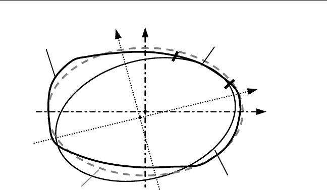
geodetic positioning systems such as GPS, it is now possible to determine
global 3-D geocentric datums.
Old maps were produced with the local datums, while new maps are
mostly produced with the geocentric datums. Therefore, to ensure consis-
tency, it is necessary to establish the relationships between the local datums
and the geocentric datums, such as WGS 84. Such a relationship is known
as the datum transformation (see Figure 4.5). NIMA has published the
transformation parameters between WGS 84 and the various local datums
used in many countries. Many GPS manufacturers currently use these
parameters within their processing software packages. It should be clear,
however, that these transformation parameters are only approximate
and should not be used for precise GPS applications. In Toronto, for exam-
ple, a difference as large as several meters in the horizontal coordinates is
obtained when applying NIMAs parameters (WGS 84 to NAD 27) as com-
pared with the more precise National Transformation software (NTv2)
produced by Geomatics Canada. Such a difference could be even larger in
other regions. The best way to obtain the transformation parameters is by
comparing the coordinates of well-distributed common points in both
datums.
54 Introduction to GPS
Region of
interest
Local
datum
Geoid
Geocentric
datum
X
CT
Y
CT
X
G
Y
G
Z
CT
C
E
Geodetic equator
Z
G
≡
≡
Figure 4.4 Geocentric and local datums.
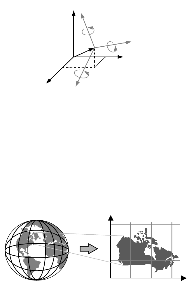
4.5 Map projections
Map projection is defined, from the geometrical point of view, as the trans-
formation of the physical features on the curved Earths surface onto a flat
surface called a map (see Figure 4.6). However, it is defined, from the
mathematical point of view, as the transformation of geodetic coordinates
(f, l) obtained from, for example, GPS, into rectangular grid coordinates
often called easting and northing. This is known as the direct map
Datums, Coordinate Systems, and Map Projections 55
Example: NAD 27 shifts
approximately: 9m, 160m, 176m−
y
CT
x
CT
z
CT
x
G
y
G
z
G
E
C
Figure 4.5 Datum transformations.
Northing
Easting
North Pole
South Pole
Figure 4.6 Concept of map projection.

projection [2, 4]. The inverse map projection involves the transformation
of the grid coordinates into geodetic coordinates. Rectangular grid coordi-
nates are widely used in practice, especially the Geomatics-related works.
This is mainly because mathematical computations are performed easier
on the mapping plane as compared with the reference surface (i.e., the
ellipsoid).
Unfortunately, because of the difference between the ellipsoidal shape
of the Earth and the flat projection surface, the projected features suffer
from distortion [3]. In fact, this is similar to trying to flatten the peel of
one-half of an orange; we will have to stretch portions and shrink others,
which results in distorting the original shape of the peel. A number of pro-
jection types have been developed to minimize map distortions. In most of
the GPS applications, the so-called conformal map projection is used [2].
With conformal map projection, the angles on the surface of the ellipsoid
are preserved after being projected on the flat projection surface (i.e., the
map). However, both the areas and the scales are distorted; remember that
areas are either squeezed or stretched [9]. The most popular conformal
map projections are transverse Mercator, universal transverse Mercator
(UTM), and Lambert conformal conic projections.
It should be pointed out that not only the projection type should
accompany the grid coordinates of a point, but also the reference system.
This is because the geodetic coordinates of a particular point will vary from
one reference system to another. For example, a particular point will have
different pairs of UTM coordinates if the reference systems are different
(e.g., NAD 27 and NAD 83).
4.5.1 Transverse Mercator projection
Transverse Mercator projection (also known as Gauss-Krüger projection)
is a conformal map projection invented by Johann Lambert (Germany) in
1772 [9]. It is based on projecting the points on the ellipsoidal surface
mathematically onto an imaginary transverse cylinder (i.e., its axis lies in
the equatorial plane). The cylinder can be either a tangent to the ellipsoid
along a meridian called the central meridian, or a secant cylinder (see
Figure 4.7 for the case of tangent cylinder). In the latter case, two small
complex curves at equal distance from the central meridian are produced.
Upon cutting and unfolding the imaginary cylinder, the required flat
map (i.e., transverse Mercator projection) is produced. Again, it should be
understood that the transverse cylinder is only an imaginary surface. As
56 Introduction to GPS

explained earlier, the projection is made mathematically through the trans-
formation of the geodetic coordinates into the grid coordinates.
In the case of a tangent cylinder, all features along the line of tangency,
the central meridian, are mapped without distortion. This means that the
scale, which is a measure of the amount of distortion, is true (equals one)
along the central meridian. As we move away from the central meridian,
the projected features will suffer from distortion. The farther we are from
the central meridian, the greater the distortion. In fact, the scale factor
increases symmetrically as we move away from the central meridian. This
is why this projection is more suitable for areas that are long in the north-
south direction.
In the case of a secant cylinder, all features along the two small complex
curves will be mapped without distortion (see Figure 4.8). The scale is true
along the two small complex curves, not the central meridian. Similar to
the tangent cylinder case, the distortion increases as we move away from
the two small complex curves.
4.5.2 Universal transverse Mercator projection
The universal transverse Mercator (UTM) is a map projection that is based
completely on the original transverse Mercator, with a secant cylinder
(Figure 4.8). With UTM, however, the Earth (i.e., the ellipsoid) is divided
into 60 zones of the same size; each zone has its own central meridian that
is located at exactly the middle of the zone [9]. This means that each zone
covers 6° of longitude, 3° on each side of the zones central meridian. Each
zone is projected separately (i.e., the imaginary cylinder will be rotated
Datums, Coordinate Systems, and Map Projections 57
Central meridian (CM)
line of tangency
Imaginary transverse cylinder
x
y
Parallel
Meridian
Central
meridian
(Equator)
Figure 4.7 Transverse Mercator map projection.
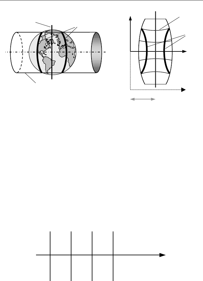
around the Earth), which leads to a much smaller distortion compared
with the original transverse Mercator projection. Each zone is assigned a
number ranging from 1 to 60, starting from l = 180° W, and increases east-
ward (i.e., zone 1 starts at 180° W and ends at 174° W with its central
meridian at 177° W); see Figure 4.9.
UTM utilizes a scale factor of 0.9996 along the zones central meridian
(Figure 4.8). The reason for selecting this scale factor is to have a more uni-
formly distributed scale, with a minimum deviation from one, over the
entire zone. For example, at the equator, the scale factor changes from
0.9996 at the central meridian to 1.00097 at the edge of the zone, while at
58 Introduction to GPS
Easting (N)
Easting (S)
500 km
Northing
SF=1
Parallel
Secant circles
SF=1
Imaginary secant cylinder
Central meridian
Figure 4.8 UTM projection.
1
180 W°
176 W°
168 W°
162 W°
23
Equator
Figure 4.9 UTM zoning.

midlatitude (f =45°Ν), the scale changes from 0.9996 at the central
meridian to 1.00029 at the edge of the zone. This shows how the distortion
is kept at a minimal level with UTM.
To avoid negative coordinates, the true origin of the grid coordinates
(i.e., where the equator meets the central meridian of the zone) is shifted by
introducing the so-called false northing and false easting (Figure 4.8). The
false northing and false easting take different values, depending on whether
we are in the northern or the southern hemisphere. For the northern hemi-
sphere, the false northing and false easting are 0.0 km and 500 km, respec-
tively, while for the southern hemisphere, they are 10,000 km, and 500 km,
respectively.
A final point to be made here is that UTM is not suitable for projecting
the polar regions. This is mainly due to the many zones to be involved
when projecting a small polar area. Other projection types, such as the
stereographic double projection, may be used (see Section 4.5.5).
4.5.3 Modified transverse Mercator projection
The modified transverse Mercator (MTM) projection is another projec-
tion that, similar to the UTM, is based completely on the original trans-
verse Mercator, with a secant cylinder [9]. MTM is used in some Canadian
provinces such as the province of Ontario. With MTM, a region is divided
into zones of 3° of longitude each (i.e., 1.5° on each side of the zones cen-
tral meridian). Similar to UTM, each zone is projected separately, which
leads to a small distortion. In Canada, the first zone starts at some point
just east of Newfoundland (l =51° 30′ W), and increases westward. Can-
ada is covered by a total of 32 zones, while the province of Ontario is cov-
ered by 10 zones (zones 8 through 17). Figure 4.10 shows zone 10, where
the city of Toronto is located.
MTM utilizes a scale factor of 0.9999 along the zones central meridian
(Figure 4.10). This leads to even less distortion throughout the zone, as
compared with the UTM. For example, at a latitude of f = 43.5° N, the
scale factor changes from 0.9999 at the central meridian to 1.0000803 at the
boundary of the zone. This shows how the scale variation and, conse-
quently, the distortion are minimized with MTM [9]. This, however, has
the disadvantage that the number of zones is doubled.
Similar to UTM, to avoid negative coordinates, the true origin of the
grid coordinates is shifted by introducing the false northing and false east-
ing. As Canada is completely located in the northern hemisphere, there is
Datums, Coordinate Systems, and Map Projections 59

only one false northing and one false easting of 0.0m and 304,800m,
respectively (see Figure 4.10).
4.5.4 Lambert conical projection
Lambert conical projection is a conformal map projection developed by
Johann Lambert (Germany) in 1772 (the same year in which he developed
the transverse Mercator projection). It is based on projecting the points on
the ellipsoidal surface mathematically onto an imaginary cone [9]. The
cone may either touch the ellipsoid along one of the parallels or intersect
the ellipsoid along two parallels. The resulting parallels are called the stan-
dard parallels (i.e., one standard parallel is produced in the first case
while two standard parallels are produced in the second case). Upon cut-
ting and unfolding the imaginary cone, the required flat map is produced
(Figure 4.11).
As with the case of the transverse Mercator projection, all features
along the standard parallels are mapped without distortion. As we move
away from the standard parallels, the projected features will suffer from
60 Introduction to GPS
304.8 km
Zone #10
l =78 W°
l =81 W
SF = 1.00008
°
SF=1
Easting
equator
CM: = 79 30 W
SF = 0.9999
l °
False
origin
False
northing
True
origin
Figure 4.10 MTM projection.
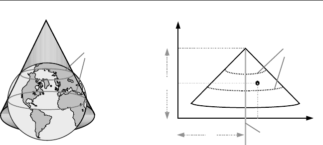
distortion. This means that this projection is more suitable for areas that
extend in the east-west direction.
This projection is designed so that all the parallels are projected as parts
of concentric circles with the center at the apex of the cone, while all the
meridians are projected as straight lines converging at the apex of the cone.
In other words, the meridians will be the radii of concentric centers. A cen-
tral meridian that nearly passes through the middle of the area to be
mapped is selected to establish the direction of the grid north (i.e., the
y-axis). To avoid negative coordinates, the origin of the grid coordinates is
shifted by introducing two constants, C1 and C2 (see Figure 4.11). The val-
ues of C1, C2, and the latitude of the standard parallels are determined by
the mapping authorities.
4.5.5 Stereographic double projection
The stereographic double projection is a map projection used in some
parts of the world, including the Canadian province of New Brunswick.
With this mapping projection, points on the reference ellipsoid are
projected onto the projection plane through an intermediate surface: an
imaginary sphere [9]. In other words, the projection is done in two steps,
hence the name double projection. First, features on the reference ellip-
soid are conformally projected onto an imaginary sphere. Second, features
on the sphere are conformally projected onto a tangent or a secant plane to
produce the required map (Figure 4.12). The latter projection is known as
stereographic projection.
Datums, Coordinate Systems, and Map Projections 61
y
P (image of pole)
x
x
y
Central
meridien
Standard
parallels
Standard
parallels
C2
C1
Figure 4.11 Lambert conical projection.
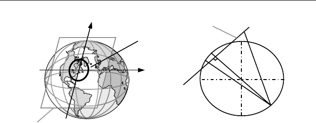
There are three cases of stereographic projection to be obtained de-
pending on the position of the projection plane relative to the sphere (i.e.,
the origin O). If the origin is selected at one of the poles of the sphere, the
projection is called polar stereographic. However, if it is selected at some
point on the equator of the sphere, the projection is called transverse or
equatorial stereographic. The general case in which the origin is selected at
an arbitrary point is called oblique stereographic. In the last case, the
meridian passing through the map origin is projected as a straight line. All
other meridians and parallels are projected as circles. In New Brunswick, a
secant projection plane is used with an origin selected at f =46° 30′ N and
l =66° 30′ W.
In the stereographic projection, a perspective point (P) is first selected
to be diametrically opposite to the origin (O). If a secant projection plane is
used, a point (A) on the surface of the sphere is projected by drawing a line
(PA) and extending it outward to A′ on the projection plane (see Figure
4.12). Points inside the secant circle, such as point B, are projected inward.
As discussed before, features along the secant circle are projected without
distortion, while other features suffer from distortion. In New Brunswick,
a scale factor of 0.999912 is selected at the origin. Similar to the previous
three map projections, a false northing and a false easting are introduced to
avoid negative coordinates.
4.6 Marine nautical charts
Marine nautical charts are maps used by mariners for navigation purposes.
They contain information such as aids to navigation and hazards. Until
62 Introduction to GPS
Secant
circle
Projection plane
B
B
A
A
O
Perspective
point
P
O
Projection plane
Figure 4.12 Stereographic double projection.
