Drennan R.D. Statistics for Archaeologists: A Common Sense Approach
Подождите немного. Документ загружается.


Chapter 18
Sampling a Site or Region with Spatial Units
Spatial Sampling Units: Points, Transects, and Quadrats ........................................ 240
Estimating Population Proportions ................................................................ 243
Estimating Population Means ...................................................................... 247
Densities ............................................................................................ 249
Sometimes the sampling elements available for selection are not the same as the
elements we wish to study. This happens most frequently in archaeology in spatially
based sampling, as in the excavation of a sample of grid squares in a site or the
survey of a sample of grid squares or transects in a region. For instance, suppose we
have a random sample of 500 sherds from a site. We may want to estimate, say, the
mean thickness of sherds at the site or the percentage of a particular pottery type in
the sherds at the site. The elements studied are sherds. Suppose the sample had been
obtained by excavating a random sample of ten grid squares. The sampling element
here is not the sherd but the grid square. It was ten grid squares that were randomly
selected from all the squares in the site grid, not 500 sherds from all the sherds in
the site. We thus have a sample, not of 500 independently selected elements, but
of ten independently selected elements, and these elements do not correspond to the
elements we need to study. Each sampling element is, in this case, a group or cluster
of a varying number of the elements of study (sherds). This fact must be allowed for
in making estimates of means or proportions.
Estimating population means and proportions from samples, and attaching error
ranges to those estimates was the subject of Chapters
9 and 11. This chapter extends
that discussion to the special case where the sampling elements are different from
the elements of study. This chapter on cluster sampling, then, can be considered
a special case of the general topics dealt with in Chapters
9 and 11, which can be
referred to as simple random sampling to distinguish them from more complex kinds
of sampling. Cluster sampling is particularly important in archaeology because so
much of the sampling we do is based on spatial units.
R.D. Drennan, Statistics for Archaeologists, Interdisciplinary Contributions
to Archaeology, DOI 10.1007/978-1-4419-0413-3
18,
c
Springer Science+Business Media, LLC 2004, 2009
239
240 CHAPTER 18
SPATIAL SAMPLING UNITS: POINTS, TRANSECTS,
AND QUADRATS
At least three different kinds of spatial sampling units might be used in archae-
ology – points, transects,andquadrats. True transects are almost never used in
archaeology, but the occasion for point sampling does sometimes arise. An example
might be in a region subject to substantial alluviation that has buried archaeological
sites beneath thick layers of sediment. An effort to estimate, say, the total area of
sites in the region might pursue a sampling program based on drilling cores down
into the sediments. Such cores could be large enough in diameter to recover rec-
ognizable artifacts if habitation deposits were intersected, making it possible to say
that a particular core was either within a site or not within a site. The cores might
well be treated as point observations: either site or not site. If a series of random
locations was selected for coring, these observations could be treated as a random
sample of the total area of the region. The proportion of cores that were within sites
would be an estimate of the proportion of the region’s total area that is within sites.
That is, if the region covered 100km
2
, and if 5% of the cores produced artifacts, we
would estimate that 5% of the region’s 100km
2
was within sites. Thus our estimate
of the total area of the sites in the region would be 5km
2
. Since in this case, the units
of sampling were points in space and the estimated proportion is a characteristic of
the space itself, it is not an instance of cluster sampling but of simple random sam-
pling, and an error range could be attached to this estimate following the procedure
discussed in Chapter
11. It would depend on the size of the sample (n), which would
be the number of cores drilled. The population (N) would be infinite. The practice
questions at the end of Chapter
6 actually comprise an example of point sampling.
Quadrats (not quadrants, which are something else) are two-dimensional spatial
units, in archaeology most often the squares in a grid system. They can also be
rectangles or other shapes. When the rectangles are long and narrow and run from
one side of the study area to the other, we often refer to them as transects,but
technically these are quadrats. True transects, like lines, have only length; their
width is 0. When an archaeologist walks along a “transect” from one side of a survey
zone to the other, the observations are not actually along a line but within a very
long narrow rectangle including some distance to either side of the path walked.
Such “transects” are usually best treated as long narrow quadrats in cluster sampling
since they do have a width (and thus an area) based on how far to either side the
archaeologist can observe whatever is to be observed.
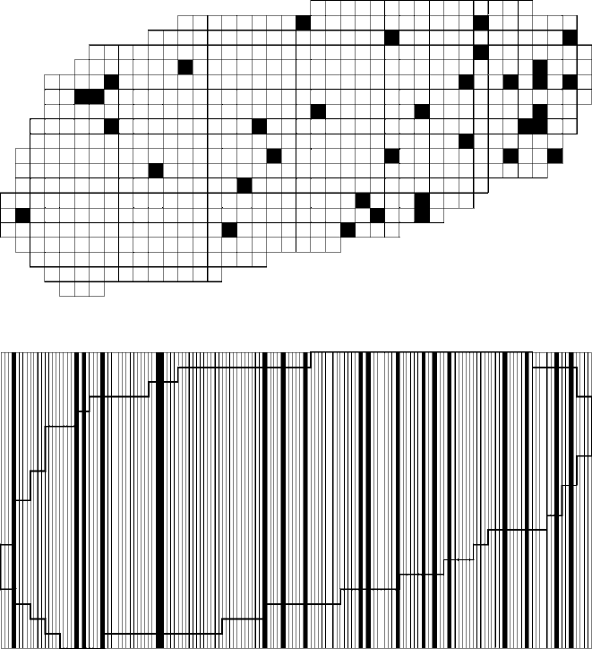
Perhaps the most frequently used method of selecting a random sample of
quadrats is to lay out a grid dividing the area to be sampled (say, a site to be
excavated) into sampling units. Each potential excavation unit in the grid system
can be assigned a number beginning with 1, and a random number table can be
used to select a sample of these quadrats. One possible result of such a sampling
scheme is shown in Fig.
18.1. The same system can be used for long narrow quadrats
(“transects”). In this case the grid divides the area to be sampled into long narrow
rectangles running from one side to the other, each as wide as the coverage of a
single “transect.” These are assigned numbers for random selection (Fig.
18.2).
SAMPLING A SITE OR REGION WITH SPATIAL UNITS 241
Figure 18.1. A random sample of quadrats selected individually.
Figure 18.2. A random sample of “transects” (actually very long narrow quadrats) selected
individually.
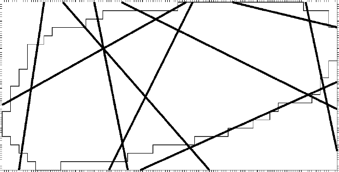
Another interesting possibility, sometimes used to avoid having all “transects”
parallel to each other, is to enclose the area to be sampled in a rectangular frame
on a map and place tick marks on all sides of the frame. The ticks should be as far
apart as the “transects” are wide. The ticks are numbered sequentially, beginning at
any point with 1 and continuing all the way around the frame until the starting point
is reached again. A random number determines one end of the first “transect,” and
a second random number determines its other end. (If the second random number
indicates a tick mark on the same side of the frame as the first, it is discarded and
another is selected.) The process is repeated until the desired number of “transects”
has been selected. One result of such a sampling scheme is illustrated in Fig.
18.3.
242 CHAPTER 18
Figure 18.3. A random sample of “transects” (actually very long narrow quadrats) determined by
random selection of their endpoints.
When n random quadrats are selected from all the quadrats in the grid at large,
it is often the case that some sample quadrats are very close to each other (pos-
sibly even adjacent), and one or more fairly large parts of the study area may be
left entirely unsampled. Figure
18.1 shows both these characteristics. This may be
unsatisfactory, for example, in excavating a site by random sampling, since (for
reasons not related to random sampling) we might not want to leave one whole
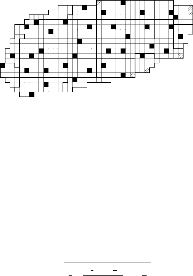
section untested. One alternative sometimes applied in such situations is systematic
sampling. As an example, suppose that we want a sample of 36 quadrats from an
area consisting of 570 quadrats. To select a systematic sample, we would subdivide
the grid of 570 quadrats into 36 subsets consisting of 16 contiguous quadrats each.
(We would add six dummy quadrats, indicated with hatching in Fig.
18.4, to fill out
the full 16 in each subset.) One quadrat would be randomly selected from each sub-
set of 16 by repeatedly selecting random numbers between 1 and 16. The sample
might be as large as 36, but if any dummy quadrats are selected, then the final sam-
ple is less than 36. The dummy quadrats never really become part of the sample,
even if they are selected, because they are imaginary. Their function is to provide
each real quadrat exactly one chance in 16 of being selected for the sample. The
resulting sample could still include adjacent quadrats, as Fig.
18.4 shows, but the
large unsampled areas that frequently occur in simple random samples of quadrats
would be impossible.
It is sometimes objected that systematic sampling is not strictly random, and tech-
nically this is true. In strict terms, the selection of one element in a random sample
should not have any effect at all on the selection of other elements. The selection of a
quadrat in a systematic sample, however, causes the other quadrats in the same sub-
set to lose their eligibility for future selection. Perhaps more important, systematic
sample selection, as described here, comprises sampling without replacement since
a quadrat, once selected, is no longer available for future selection. The equations
SAMPLING A SITE OR REGION WITH SPATIAL UNITS 243
Figure 18.4. A systematic random sample of quadrats.
given in this chapter, like those in Chapters 9 and 11, are for sampling with replace-
ment. The impact of these two technical problems, however, is minimal under most
circumstances. (And especially for the form of systematic sampling described here,
which violates the strictest norms of random sampling less than other variants of
systematic sampling that have been suggested.) The attractiveness of working with
a spatial sample that avoids leaving any large sections of the study area unexamined
usually outweighs these minor technical objections.
ESTIMATING POPULATION PROPORTIONS
The best estimate of a population proportion in cluster sampling is the same as in the
case of simple random sampling – simply the proportion in the sample. For instance,
suppose we excavate a random sample of ten grid squares in a site and obtain 500
sherds altogether. If 35% of this cluster sample of sherds are cord marked, we would
estimate that 35% of the sherds in the site are cord marked.
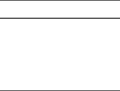
The error range corresponding to this estimate, as with simple random sam-
pling, is based on the standard error of the proportion, but the standard error of
the proportion in cluster sampling is calculated by the formula
SE =
1
n
⎛
⎝
∑
x
y
−P
2
yn
Y
2
n −1
⎞
⎠
1 −
n
N
where SE = standard error of the proportion, n = sample size (i.e., number of units
in the sample), N = population size (i.e., number of units in the population), x =
number of object x in a unit, y = number of object y in a unit, P = estimate of the
244 CHAPTER 18
Table 18.1. Sherds from a Random Sample of
Ten Excavation Units
xy
Unit No. of cord-marked sherds No. of sherds
07 10 32
18 13 27
29 16 38
31 19 73
37 17 55
56 21 41
72 18 63
83 30 81
87 19 56
91 12 34
proportion x/y for the population, and Y =
∑
y, that is, the total number of object y
in n units.
Note that this formula incorporates the finite population corrector 1 −(n/N) dis-
cussed in Chapter
9. Since the population is usually finite and definable in spatial
sampling, this correction can usually be applied. If the population is very large,
however, compared to the size of the sample, the finite population corrector has a
negligible effect on the result because it is only trivially different from one.
Table
18.1 provides an example of the calculations involved. It describes a ran-
dom sample of ten excavated grid units from a site whose total area is 100 grid
units. The sample size, n, is thus 10, and the population size, N, is 100. These ten
excavation units yielded a total of 500 sherds, some of which were cord marked. We
wish to estimate the proportion of cord-marked sherds in the ceramic assemblage
of the site as a whole. The units are identified by their sequential numbers, which
were used to select the random sample. Since the proportion we wish to estimate
is the proportion of cord-marked sherds in the ceramic assemblage, x is the number
of cord-marked sherds in each square and y is the total number of sherds in each
square.
∑
x,orX, is 175 – the total number of cord-marked sherds found in all ten
units. And
∑
y,orY, is 500 – the total number of sherds found in all ten units. The
proportion of cord-marked sherds in the ceramic assemblage for the entire sample,
then, is (175/500)=0.350; 35.0% of the sherds are cord marked. Since the best
estimate of the population proportion is the sample proportion, we would estimate
that 35.0% of the sherds in the site are cord marked.
Table
18.2 extends Table 18.1 into a step-by-step calculation of the summation
needed for the standard error calculation. The first calculation step (x/y) results in
the fourth column, simply dividing x by y for each excavation unit. This quantity is,
of course, the proportion of cord-marked sherds for each of the ten excavated units.
This proportion varies from a low of 26.0% in unit 31 to a high of 51.2% in unit 56.
It is this variation from one sample unit to the next in the proportion of interest to
us that will form the basis for the error range.
SAMPLING A SITE OR REGION WITH SPATIAL UNITS 245
Table 18.2. Calculation of the Summed Weighted Deviations
from the Overall Sample Proportion
Unit xY
x
y
x
y
−P
x
y
−P
2
yn
Y
yn
Y
2
x
y
−P
2
yn
Y
2
07 10 32 0.313 −0.037 0.001369 0.640 0.409600 0.000561
18 13 27 0.481 0.131 0.017161 0.540 0.291600 0.005004
29 16 38 0.421 0.071 0.005041 0.760 0.577600 0.002912
31 19 73 0.260 −0.090 0.008100 1.460 2.131600 0.017265
37 17 55 0.309 −0.041 0.001681 1.100 1.210000 0.002034
56 21 41 0.512 0.162 0.026244 0.820 0.672400 0.017646
72 18 63 0.286 −0.064 0.004096 1.260 1.587600 0.006503
83 30 81 0.370 0.020 0.000400 1.620 2.624400 0.001050
87 19 56 0.339 −0.011 0.000121 1.120 1.254400 0.000152
91 12 34 0.353 0.003 0.000009 0.680 0.462400 0.000004
∑
y = 500
∑
x
y
−P
2
yn
Y
2
= 0.053132
For the fifth column in the table, x/y−P,the overall sample proportion (0.350) is
subtracted from each excavation unit’s proportion. This is recognizable, of course, as
a deviation – the extent to which the proportion of cord-marked sherds in each exca-
vation unit deviates from the overall proportion in the whole sample taken together.
In a manner familiar from all our calculations of standard deviations, the next step,
(x/y −P)
2
, squares the deviations from the fifth column to arrive at the sixth col-
umn. The sixth column is one of the two terms that must be multiplied together to
arrive at the quantity to be summed.
The other term is, in effect, a weighting factor. The sixth column is a set of
squared deviations. In cluster sampling we weigh more heavily the deviations of
units that produce more evidence (that is, in this example, more sherds). This makes
some intuitive good sense if you remember that generally we get a more accurate
estimate from a larger sample than from a smaller sample. In effect, each excava-
tion unit is a single sample of sherds from the site. These single samples can be
expected to produce somewhat different results – that is, to deviate from the overall
proportion. If they all deviate very little from the overall proportion, then the error
range associated with our cluster sampling estimate should be relatively small. (The
consistency from one excavation unit to another makes us willing to believe the site
is fairly homogeneous and our estimate fairly precise.) We will be more concerned
about imprecision in our results if units that produce large numbers of sherds deviate
widely from the overall proportion than if units producing small numbers of sherds
deviate widely from the overall proportion. Thus, when we sum up the squared devi-
ations, we will count the deviations in units that produced large numbers of sherds
more heavily than deviations in units that produced small numbers of sherds (where
the deviations are more likely to be simply the result of random vagaries in smaller
samples).
246 CHAPTER 18
The seventh column begins the calculation of this weighting factor, which is
based on how “large” the sample unit is in terms of the elements we are studying. In
this example the elements we are studying are sherds, so the large (heavily weighted)
sample units are those that produced large numbers of sherds. The seventh column
(yn/Y) is simply the number of sherds in a unit times the number of units in the
sample (10) divided by the total number of sherds in the sample (500). (It is useful
to know, for checking calculations, that the sum of the seventh column is always n,
the number of units in the sample.) The eighth column is simply the square of the
seventh column.
The last column in Table
18.2 is the product of the sixth column and the eighth
column, and is the quantity to be summed for all ten sample units: (x/y−P)
2
(yn/Y)
2
.
The sum of this quantity for all sample units is indicated at the bottom of the last
column: 0.053132.
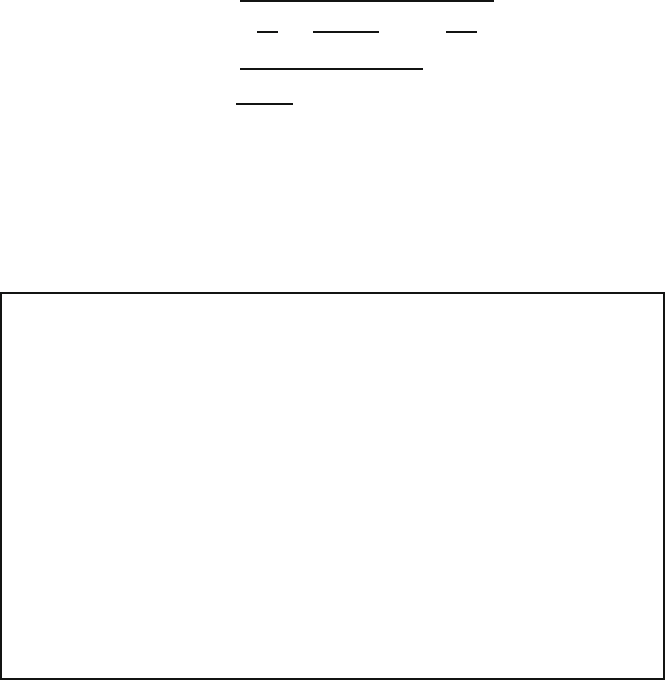
Substitution of numbers into the formula given above for the standard error of
the proportion is now relatively straightforward:
SE =
1
10
.053132
10 −1
1 −
10
100
=
(.100)(.005904)(.900)
=
√
.00531 = .023
The standard error of the proportion, then, is 0.023, so the estimate of the proportion
of cord-marked sherds in the ceramic assemblage at the site could take the form
35.0%±2.3%. This error range can be increased by multiplying it by an appropriate
value of t to make it a statement at whatever level of confidence is desired (see
Statpacks
Very few computer statpacks provide for the calculation of standard errors for
cluster samples. They can certainly be calculated by hand, although the sum-
mation that forms the numerator of the middle fraction is tedious. The ease
with which this calculation is illustrated as a table in which each column is
derived by relatively simple repeated calculation from the previous one, how-
ever, suggests a computerized solution. Spreadsheets were designed precisely
for performing such calculations, and are probably the fastest, easiest, and
most commonly available option for getting a computer to do most of the bor-
ing work. The provisions that statpacks provide for transforming variables can
also often be adapted to this task, since each column in Tables
18.2 and 18.4
really is simply a new variable whose values are calculated by a repeated math-
ematical manipulation from previous columns. Some database managers also
provide mathematical tools that can perform calculations like this.

SAMPLING A SITE OR REGION WITH SPATIAL UNITS 247
Chapter 9). For example, if we wish to express our estimate with an error range at
the 95% confidence level, we look in Table
9.1 for the value of t corresponding to
95% confidence and nine degrees of freedom (n−1). This value is 2.262. Thus the
error range we seek is (2.262)(0.023)=0.052. We would thus say that we are 95%
confident that cord-marked sherds represent 35.0%±5.2% of the sherds at this site.
ESTIMATING POPULATION MEANS
As with proportions, the best estimate of the population mean is the overall mean
in the sample. Table
18.3 provides example data from the same sample of exca-
vated units we have been considering. The data here are lengths in millimeters of
the projectile points encountered in these same excavation units. Altogether 21 pro-
jectile points were recovered, with an overall mean length of 21.8 mm. We would
thus estimate that the mean length of all the projectile points in the site is 21.8 mm.
The standard error we need in order to put an error range with this estimated
mean is calculated in a manner very similar to the standard error of the proportion:
SE =
1
n
⎛
⎝
∑
x −X
2
yn
Y
2
n −1
⎞
⎠
1 −
n
N
where SE = standard error of the mean, n = sample size (i.e., number of clusters
in the sample), N = population size (i.e., number of clusters in the population),
x = mean of x in a cluster, X = estimated population mean of x (i.e., the overall
sample mean), y = number of things in a cluster measured for x,andY =
∑
y (i.e.,
the total of y in n clusters).
Table 18.3. Lengths of Projectile Points
from a Sample of Ten Excavation Units
X
Unit Projectile point lengths (mm)
07 15, 19, 23
18 17
29 18, 23
31 18, 18, 27
37 18, 19
56 24
72 20, 21, 26, 28, 29
83 16
87 28
91 25, 26

248 CHAPTER 18
Table 18.4. Calculation of Summed Deviations from Overall Sample Mean
Unit Y x x −X (x −X)
2
yn
Y
yn
Y
2
(x −X)
2
yn
Y
2
07 3 19.0 −2.87.840 1.429 2.042 16.009
18 1 17.0 −4.823.040 0.476 0.227 5.230
29 2 20.5 −1.31.690 0.952 0.906 1.531
31 3 21.0 −0.80.640 1.429 2.042 1.307
37 2 18.5 −3.310.890 0.952 0.906 9.866
56 1 24.0 2.24.840 0.476 0.227 1.099
72 5 24.8 3.09.000 2.380 5.664 50.976
83 1 16.0 −5.833.640 0.476 0.227 7.636
87 1 28.0 6.238.440 0.476 0.227 8.726
91 2 25.5 3.713.690 0.952 0.906 12.403
X = 21.8
∑
(x −X)
2
yn
Y
2
= 114.783
Once again, the complicated calculation is the summation that forms the numer-
ator of the middle fraction, and this summation is quite similar to the summation
required for the standard error of the proportion. Table
18.4 shows this calculation
carried out.
In this instance, y is the number of projectile points found in each unit. For each
excavation unit, we calculate a mean projectile point length based on the projectile
points in that unit. This mean appears in the third column of Table
18.4. The devi-
ation we are interested in this time is the difference between the mean projectile
point length for each unit and the overall mean in the sample (the fourth column).
As usual, this deviation is squared (the fifth column). The weighting factor works
just as it did in the case of estimating proportions (the sixth and seventh columns).
The final product is summed in the last column.
The results can then be substituted in the formula on the preceding page as
follows:
SE =
1
10
114.783
10 −1
1 −
10
100
=
(.100)(12.7537)(.900)
=
√
1.1478 = 1.07mm
To use this standard error as an error range at the 95% confidence level, as we did
with the standard error of the proportion earlier in the example, we would multiply
it by the value of t for nine degrees of freedom and 95% confidence, which contin-
ues to be 2.262. Thus the error range would be (1.07)(2.262)=2.42mm, and we
would be 95% confident that the mean length of all the projectile points in the site
is 21.8mm±2.4mm.
