Ware C. Information Visualization: Perception for Design
Подождите немного. Документ загружается.

solutions may be stored in visual working memory, or a single route may use the entire capac-
ity of this limited resource.
Once a complete path has been identified, it must be retained in some way while alternate
solutions are found. If a route is complex, part of the task can be held in verbal-propositional
form (e.g., the western route or the Bordeaux route), and this label can be used later as the start-
ing point for a rapid visual reconstruction. An interactive computer-based map can support this
loop by allowing a user to highlight a potential solution, as illustrated for the Bordeaux, Poitiers,
Paris path in Figure 11.13. This will free up more capacity in searching for alternative paths.
As a result of this process, three alternative solutions are identified. A western route goes
through Toulouse, Bordeaux, Nantes, Caen, and Rouen. A central route shares a path to
Bordeaux but then goes via Poitiers, Orleans, and Paris. An eastern route would get us to Paris
via Montpellier, Avignon, Lyon, and Dijon.
The Eye Movement Control Loop
The detailed execution of the pattern-finding process is carried out through a series of eye move-
ments to capture each of the major continuous paths meeting the criteria. The eye movements
are planned using the task-weighted spatial map of proto-patterns. Those patterns most likely to
be relevant to the current task are scheduled for attention, starting with the one weighted most
significant. As part of this process, partial solutions are marked in visual working memory by
setting placeholders in the egocentric spatial map. For example, the part of the route that goes
to Bordeaux might be marked while the alternatives for the rest of the trip are explored. Once
an entire path has been identified, it may be checked with a set of rapid eye movements.
This stage may be supported in an interactive system by some form of both spatial and
semantic scaling (Furnas 1986). At the early planning stage, only major highways and good sec-
ondary roads are required, so it will be easier to carry out this task if the map is simplified to
show only these. A smaller map may also be easier to parse with eye movements. Later planning
stages will require more detail and zoomed-in map views.
The Intrasaccadic Scanning Loop
This is the innermost loop of the visual query system, where the information available from a
single fixation is processed. Sections of lines representing roads are successively formed through
selective tuning of the pattern-finding mechanism (Dickinson et al., 1997). Those representing
minor roads going in the wrong direction will be rejected, whereas those representing connected
major roads going in the right direction will be held in visual working memory up to a limit of
three or four road segments. City names will also be processed, causing information about them
to be loaded into verbal-propositional memory.
Implications for Interactive Visualization Design
The model presented here has a number of implications for data display systems. The following
are perhaps the three most important:
374 INFORMATION VISUALIZATION: PERCEPTION FOR DESIGN
ARE11 1/20/04 4:56 PM Page 374
1. Data should be presented in such a way that informative patterns are easy to perceive,
allowing us to take advantage of the pattern-finding capabilities of the middle stage of
visual processing.
2. The cognitive impact of the interface should be minimized, so that thinking is about the
problem, not the interface.
3. The interface should be optimized for low-cost, rapid information seeking.
In the following sections, we consider these implications in more detail, first speculating on the
nature of visual queries and then in the context of interactive data navigation techniques, both
in isolation and as they are encapsulated in various experimental applications.
Visual Query Patterns
The patterns that can be part of visual problem solving are infinitely diverse: path finding in
graphs, quantity estimation, magnitude estimation, trend estimation, cluster identification, cor-
relation identification, outlier detection and characterization, target detection, identification of
structural patterns (e.g., hierarchy, degree of coupling), to name a few.
For a visual query to be performed rapidly and with a low error rate, it should consist of a
simple pattern or object that can be held in visual working memory. Three elementary queries,
or one more complex query, can be held in visual working memory. Other cognitive strategies
are required when a query is more than the capacity of visual working memory. Figure 11.14
Thinking with Visualizations 375
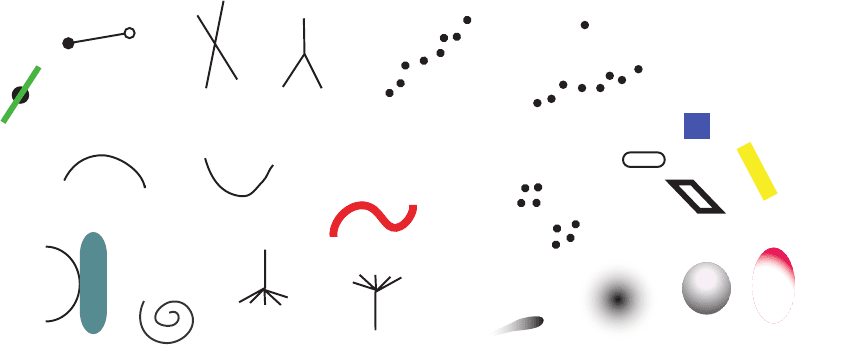
Figure 11.14 Any simple pattern can form the basis for a visual query. Expertise with a particular kind of visual display
will allow for more complex queries.
ARE11 1/20/04 4:56 PM Page 375
gives some suggestions of patterns that might constitute simple queries. The number of possible
patterns is astronomical. Knowledge from vision research about pattern perception and pre-
attentive vision can provide a good understanding of the kinds of visual queries that can be
processed rapidly. After all, most studies of perception take the form of having subjects make
repeated visual queries of a display.
We may be able to query patterns of considerably greater complexity as we become expert
in a particular set of graphical conventions, such as a circuit diagram. A chess master can
presumably make visual queries consisting of patterns that would not be possible for a novice.
Nevertheless, even for the expert, the laws of preattentive processing and elementary pattern per-
ception will make certain patterns much easier to see than others.
Costs of Navigation
In the previous chapter, we discussed various methods for navigating through information spaces.
Now we briefly reconsider these in the light of the current theory. The benchmark point of com-
parison for all navigation techniques should be saccadic eye movement. This allows us to acquire
a new set of informative visual objects in 100–200msec. Moreover, information acquired in this
way will be integrated readily with other information that we have recently acquired from the
same space. Thus, the ideal visualization is one in which all the information for visualization is
available on a single high-resolution screen. Even if the information is in different windows, the
cost of navigating there is only a single eye movement, or in the worst case, an eye movement
plus a head movement if the angle is large. Consider some of the computer-based alternatives to
eye movements.
Hypertext Link
Clicking a hypertext link involves a 1–2sec guided hand movement and a mouse click. This can
generate an entirely new screenful of information. However, the cognitive cost is that the entire
information context typically has changed, and the new information may be presented using
a different visual symbol set and different layout conventions. Several seconds of cognitive re-
orientation may be required.
Brushing, Dynamic Queries, and Hover Queries
Both brushing (Ahlberg et al., 1992) and dynamic queries (Becker and Cleaveland, 1987) allow
information to be revealed on some data dimension by making a continuous mouse movement.
Hover queries cause extra information to pop up rapidly as the mouse is dragged over a series
of data objects. All three of these require a mouse movement typically taking about two seconds.
After this initial setup time, the mouse can allow rapid scanning in a tight, exploratory visual
feedback. The data is continuously modified according to the mouse movement. This may enable
an effective query rate of several per second, similar to the rate for eye movements. However,
this rate is only possible for quite specific kinds of query trajectory; we cannot jump from point
to point in the data space as we can by moving our eyes.
376 INFORMATION VISUALIZATION: PERCEPTION FOR DESIGN
ARE11 1/20/04 4:56 PM Page 376

Walking or Flying in Virtual Reality
Compared to eye movements or rapid exploration techniques like hyperlink following or brush-
ing, navigating a virtual information space by walking or flying is likely to be both considerably
slower and cognitively more demanding. In virtual reality, as in the real world, walking times
are measured in minutes at best. Even with virtual flying interfaces (which do not attempt to sim-
ulate real flying and are therefore much faster), it is likely to take tens of seconds to navigate
from one vantage point to another. In addition, the cognitive cost of manipulating the flying inter-
face is likely to be high without extensive training. And although walking in virtual reality
simulates walking in the world, it cannot be the same, so the cognitive load is higher.
Table 11.1 gives a set of rough estimates of the times and cognitive costs associated with
different navigation techniques. When simple pattern finding is needed, the importance of having
a fast, highly interactive interface cannot be emphasized enough. If a navigation technique is
slow, then the cognitive costs can be much greater than just the amount of time lost, because an
entire train of thought can become disrupted by the loss of the contents of both visual and non-
visual working memories.
The figures in Table 11.1 should be taken as ballpark estimates; they have not been
empirically validated.
Magnifying Windows vs. Zooming
As an example of how visual working memory capacity can be used to make substantial design
decisions, we now consider the problem of when extra windows are needed in a visualization
interface. Consider the task of finding similar or identical patterns spaced far apart in a large
geographical space, as illustrated in Figure 11.15. With a zooming interface, it is necessary to
Thinking with Visualizations 377
Navigation Technique Time Cognitive Effort
Attentional object switch within a fixation 50msec Minimal
Saccadic eye movement 150msec Minimal
Hypertext jump 2sec Medium
Brushing 2sec setup, 250sec/query Medium
Dynamic queries 2sec setup, 250sec/query Medium
Floating queries 2sec setup, 250sec/query Medium
Zooming 2sec setup + log spatial change High
Flying 30sec–3min High
Walking 30sec–10min High
Table 11.1 Approximated times for navigation in information spaces
ARE11 1/20/04 4:56 PM Page 377
zoom in to and look at one pattern, then hold that pattern in visual working memory
while zooming out to seek other patterns. The pattern in visual working memory is then
compared to new patterns seen during the search process. If a possible match is found, it
may be necessary to zoom back and forth to confirm details of the match. An alternative method
is to use extra windows to magnify parts of the main display. When two such windows are in
position, it is possible simply to make eye movements between them to assess the match more
rapidly.
The critical resource here is visual working memory capacity, because this determines how
many visits are required to make the comparison. If the target pattern is simple enough to be
held in visual working memory, then zooming will often be more efficient, because it avoids the
overhead of setting up multiple windows. If more than three items are in the target pattern, then
it will be necessary to zoom back and forth between them, and the multiwindow solution will
be faster.
378 INFORMATION VISUALIZATION: PERCEPTION FOR DESIGN
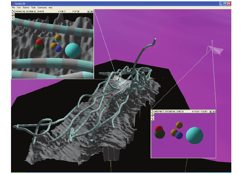
Figure 11.15 Subwindows show a magnified view together with the source of the information in the background
overview.
ARE11 1/20/04 4:57 PM Page 378
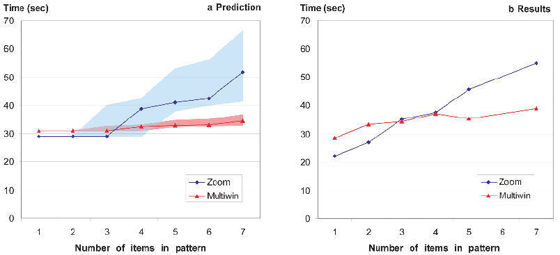
We have modeled two user interfaces—simple zooming vs. multiple windows—considering
visual working memory capacity as a critical resource and estimating the number of zooms vs.
window movements necessary to complete the task of finding identical groups of simple shapes
clustered but widely separated in a geographical space (Plumlee and Ware, 2002). The predictions
of the model are shown in Figure 11.16(a), modeled for capacities of visual working memory at
two, three, and four items, leading to a range of predictions as shown by the broad colored wedges.
As can be seen, the model predicts that zooming will have an initial benefit because extra windows
take more time to set up. However, as the number of objects increases, the extra window interface
will be beneficial. The measured results, as shown Figure 11.16(b), closely matched the prediction.
Interfaces to Knowledge Structures
Although a visual icon or object can activate logical verbal information rapidly and effectively,
it can do so only if this information has a strong, previously learned association between the
image and the meaning. This is why advertisers spend millions promoting logos. It is also why
the design of symbol sets is so critical. Once a symbol set has been learned by a wide group of
users, the cost of changing it can be huge.
Concept Maps and Mind Maps
A more complex way to map out knowledge structures is to use some form of node–link diagram,
with nodes representing concepts and the links representing the relationships between them. The
Thinking with Visualizations 379
Figure 11.16 Model predictions are shown on the left. Measured task performance is shown on the right. Multiple
windows speed performance relative to the use of a zooming interface when the number of objects to be
compared is five or more.
ARE11 1/20/04 4:57 PM Page 379
technique of sketching out links between concepts, as shown in Figure 11.10, has received con-
siderable attention from educational theorists. These concept maps (or mind maps as they are
sometimes called) are often recommended as study aids for students (Jonassen et al., 1993).
Usually, such maps are constructed informally by sketching them on paper, but computer-based
tools also exist. Essentially, a concept map is a type of node–link diagram in which the nodes
represent concepts and the links represent relationships between concepts. It can be used to make
the structure of a cognitive concept network explicitly available. An individual can use a concept
map as a tool for organizing his or her own personal concept structure, and it may reveal pat-
terns of relationships between ideas that had not been evident when the concepts were stored
internally. A concept map can also be constructed in a group exercise, in which case it becomes
a tool for building a common understanding.
Constellation
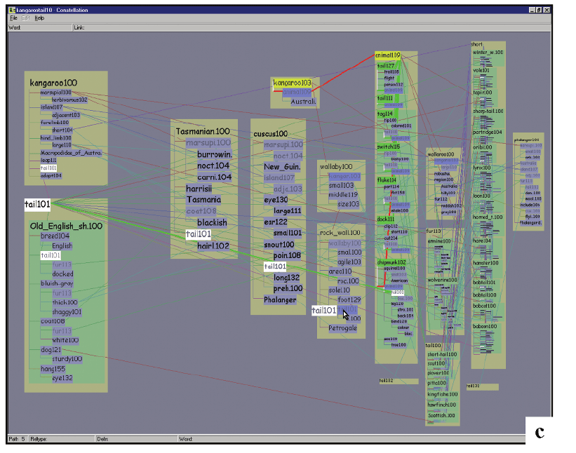
The Constellation system of Munzner et al. (1999) provides an example of how a highly inter-
active node–link visualization can provide views into very a complex semantic network, far larger
than can be displayed on a static concept map. Figure 11.17 shows a screen shot, but this static
image does not do justice to the system. Constellation uses hover queries to allow for rapid high-
lighting of subsets of the graph. Links attached to a node became highlighted as the cursor passes
over the node. In addition, when the user clicks on a particular node, Constellation uses intelli-
gent zoom, causing the graph to rearrange itself partially so that closely related semantic con-
cepts are allocated more screen space and larger fonts. By using these techniques, a large amount
of semantic information can be accessed very quickly.
Note that the rapid query techniques get around the usual problems of graph layout. Most
of the work in graph layout is aimed at producing aesthetically pleasing drawings of graph struc-
tures, by paying particular attention to minimizing edge crossings of nodes (Di Battista et al., 1998).
A good, clear static graph drawing of the information in Figure 11.17 by the conventional cri-
teria, is probably impossible, because there are simply too many links. In Constellation, Munzer
abandoned the usual criteria, allowing edges to cross each other and to cross nodes. Using inter-
active techniques to reveal information as needed allowed visual access to much larger structures.
The node–link diagram is a method for looking at networks of concepts, but a common way
of organizing knowledge is through a hierarchy, and the most common visualization of a hier-
archy is a tree. A degree-of-interest tree (Card and Nation, 2002) is a tree visualization that uses
a degree-of-interest function (Furnas, 1986) to show or hide interactively parts of the tree struc-
ture based on their estimated relevance to a selected node. It enables a large tree structure to be
interactively explored.
Linking Computer-Based Analysis with Visualization
The greatest power in information visualization arises when the power of computers to sample
and condense very large amounts of information is combined with a visual interface. If the com-
puter contains a model of a knowledge domain, then this model can form the basis for inter-
380 INFORMATION VISUALIZATION: PERCEPTION FOR DESIGN
ARE11 1/20/04 4:57 PM Page 380
active applications that visually hide and show information based on the estimated relevance to
some task. Only the most relevant information is being displayed to the user.
Psychologists have developed a number of other tools for mapping the cognitive structure
of concepts, besides simple sketching. One is based on multidimensional scaling (Shepard, 1962).
The technique involves giving participants pairs of examples of the ideas or objects to be mapped
and asking them to rate the similarity. For example, if the goal is to find out how someone con-
ceptualizes different kinds of animals, that person is given pairs of cat–dog, mouse–cow, cat–ele-
phant, and so on, and asked to give each pair a similarity rating. Once all pair ratings for the
entire set have been obtained, the multidimensional scaling technique is used to compute a math-
ematical space in which similar animals are close together. This technique can sometimes reveal
Thinking with Visualizations 381
Figure 11.17 A screen image of the Constellation system showing a view into the MindNet semantic network
database.
ARE11 1/20/04 4:57 PM Page 381
the nature of the most significant dimensions of this space, but often the mathematical dimen-
sions that are found have little intuitive meaning. The multidimensional scaling technique does
not show links between concepts; it only shows proximity. Concepts that are close together in
the space are assumed to be related.
Multidimensional scaling can be used as a tool in visualizing concept spaces, but it suffers
from the problem that the space created can have a high dimensionality. However, the dimen-
sionality can be reduced by simply showing the two or three most significant dimensions as a
2D or 3D scatter plot. More dimensions can be added by color-coding or changing the shape of
each data glyph, as discussed in Chapters 4 and 5.
The analysis of large text databases is an application area where it is useful to get a view of
a large number of points in a multidimensional conceptual space. The SPIRE system creates a
classification of documents with respect to a keyword query and can be applied to databases con-
sisting of hundreds of thousands of documents (Wise et al., 1995). The result is a set of vectors
in an n-dimensional space. To help people understand the resulting clusters of documents, Wise
et al. created a visualization called a ThemeScape, which shows the two most important dimen-
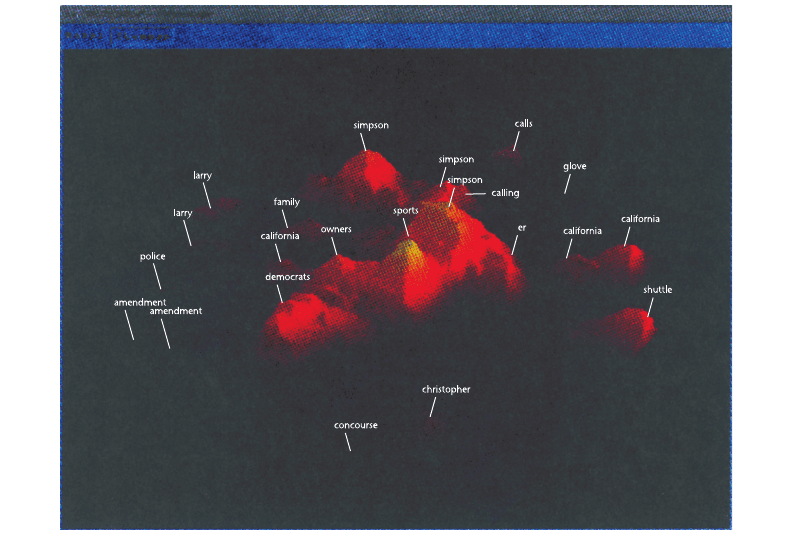
sions as a kind of data landscape. This is illustrated in Figure 11.18. Flags on the tops of hills
382 INFORMATION VISUALIZATION: PERCEPTION FOR DESIGN
Figure 11.18 An entire week of CNN news stories is summarized in a ThemeScape visualization (Wise et al., 1995).
ARE11 1/20/04 4:57 PM Page 382
label and identify the largest clusters of documents in this space. Essentially, a ThemeScape uses
the two most significant dimensions of the space to create a smoothed two-dimensional his-
togram. This can be regarded as a different kind of concept map—one that does not show the
links but uses spatial proximity and salience to show the major concentrations of information
and, to some extent, their relationships. This kind of display will be useful when two dimensions
really do capture most of the variability in the data. If more dimensions are significantly involved,
then color-coding and more interactive exploratory techniques may be necessary.
Trajectory Mapping
Trajectory mapping is a recent psychological method for mapping out the structure of concept
spaces (Richards and Koenderink, 1995). Unlike multidimensional scaling, trajectory mapping
explicitly finds links between concepts. In trajectory mapping, a participant is also given pairs of
examples from the set of objects (or concepts) to be organized. However, in this case the person
is asked to look at the objects that make up the pair and extrapolate on the basis of some dif-
ference between them, then select another sample concept that represents the result of that extra-
polation. For example, someone given a mouse and a dog as exemplars might extrapolate to a
cow if they thought size was a critical variable, or might extrapolate to a monkey based on a
concept of animal intelligence. Participants are also allowed to say that there is no meaningful
extrapolation, in which case one of the exemplars becomes a terminator in the resulting concept
graph. This exercise is designed to produce a set of cognitive pathways linking concepts. Strong
pathways can be distinguished from weak ones.
Lokuge et al. (1996) used a combination of trajectory mapping and multidimensional scaling
to create different visual maps linking various tourist attractions in the Boston area, such as
museums and open-air markets. The results were based both on conceptual similarity between
the different items and the pathways between them. One of the results is shown in Figure 11.19.
This technique could be used to generate customized tours automatically. The tourist would enter
a set of interests, and the system would combine this with the database information to create a
walking tour of suitable attractions.
It should be recognized that no matter how they are generated, concept maps are somewhat
crude instruments for making knowledge explicit. All of them reveal only that there is a rela-
tionship between ideas, not the nature of that relationship.
Creative Problem Solving
We commonly divide problem-solving activities into the routine and the creative. The essential
difference is that in creative thinking, the emphasis is on novelty. Theories of creative thinking
generally break the process into three states: preparation, production, and judgment (Matlin,
1994). Visualization can help with all three.
Thinking with Visualizations 383
ARE11 1/20/04 4:57 PM Page 383