Wallace J.M., Hobbs P.V. Atmospheric Science. An Introductory Survey
Подождите немного. Документ загружается.

394 The Atmospheric Boundary Layer
where L is the Obukhov length. For statically unsta-
ble conditions, surface-layer similarity theory yields
(9.26)
Exercise 9.4 Integrate Eq. (9.25) to derive an
expression for wind speed as a function of height
under statically stable conditions, assuming that V 0
at z z
0
and u
*
and L are constant.
Solution: Separate variables:
Then integrate to obtain
Upon rearranging, this can be written as a dimen-
sionless wind speed versus a dimensionless height
Thus, wind varies both logarithmically and linearly
with height; hence, the vertical wind profile observed
under stable conditions is said to be log-linear. ■
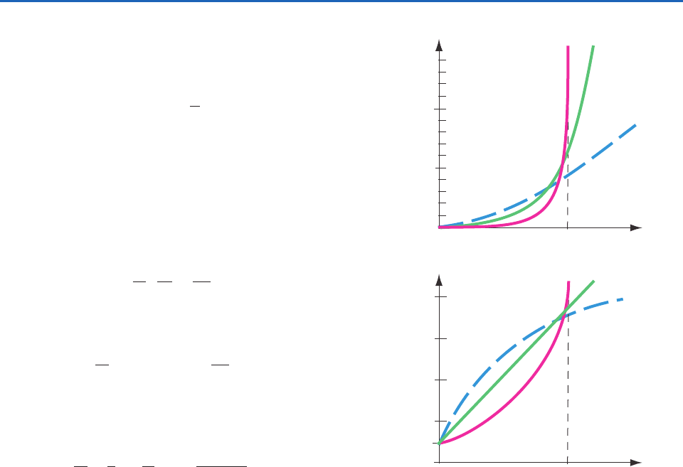
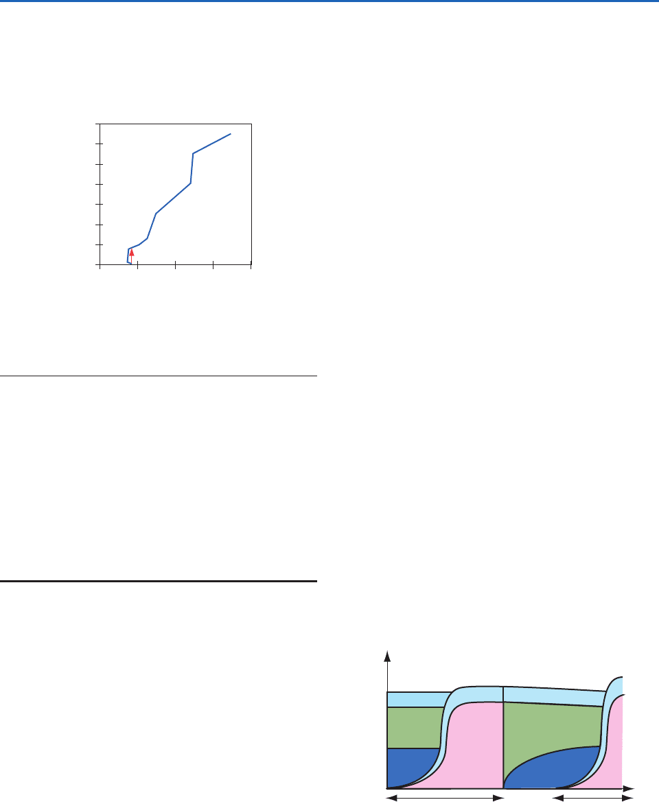
Vertical profiles of wind speed for stable, neutral,
and unstable profiles are plotted in Fig. 9.17 on linear
and logarithmic height scales. Just above the Earth’s
surface wind speed increases more rapidly with
height in the unstable profile than in the stable pro-
file because the more vigorous turbulence that
occurs under unstable conditions is more effective at
mixing momentum downward. For statically stable
surface layers, the turbulence is not strong enough to
homogenize the surface layer: in effect, the winds
above the surface layer are decoupled from the drag
at the ground.
Turbulence communicates drag from the ground
throughout the middle part of the mixed layer during
daytime, resulting in homogenized, uniform wind
speed with height that is slower than geostrophic
(i.e., subgeostrophic) and which crosses the isobars at
a small angle toward lower pressure. Above the cap-
ping inversion or entrainment zone, winds quickly
recover to their full geostrophic values because there
is no turbulence there to communicate surface drag
information. Thus, wind shear tends to be concen-
V
u
*
1
k
ln
z
z
0
8.1
(z z
0
)
L
V 0
u
*
k
ln z ln z
0
8.1
L
(z z
0
)
dV
u
*
k
dz
z
8.1
L
dz
M
1 15
z
L
1
4
trated in both the surface layer (SL) and the entrain-
ment zone (EZ), as sketched in Fig. (9.16).
At night, the suppression of turbulence by the sta-
ble boundary layer causes the air in the residual layer
to suddenly be frictionless. This residual-layer air
accelerates toward geostrophic, but due to the
Coriolis force undergoes an inertial oscillation in
which the wind vector oscillates around the
geostrophic wind speed. The winds become faster
than geostrophic (supergeostrophic) during a portion
of the inertial oscillation, causing a low-altitude
wind-speed maximum, called the nocturnal jet, which
is a type of low-level jet. Meanwhile, closer to the
Stable
0
100
50
Unstable
Neutral
0
Wind Speed, V
V
BL
Height, z (m)
(a)
Stable
0.01
100
1
Unstable
Neutral
0
Wind Speed, V
V
BL
Height, z (m)
(b)
10
0.1
z
o
Fig. 9.17 Typical variation of wind speeds with height in the
surface layer for different static stabilities, plotted on (a) linear
and (b) semi-log graphs. From Meteorology for Scientists and
Engineers, A Technical Companion Book to C. Donald Ahrens’
Meteorology Today, 2nd Ed., by Stull, p. 77. Copyright 2000.
Reprinted with permission of Brooks/Cole, a division of
Thomson Learning: www.thomsonrights.com. Fax 800-730-
2215; and from R. B. Stull, An Introduction to Boundary
Layer Meteorology, Kluwer Academic Publishers, Dordrecht,
The Netherlands, 1988, Fig. 9.5, p. 377, Copyright 1988
Kluwer Academic Publishers, with kind permission of Springer
Science and Bussiness Media.]
P732951-Ch09.qxd 9/12/05 7:48 PM Page 394
9.3 Vertical Structure 395
ground, the winds become nearly calm because the
air is affected by drag at the ground, but is no longer
subject to turbulent mixing of stronger winds from
aloft because turbulence has diminished. Figure 9.18
shows the diurnal variation of wind speed at various
heights within an idealized boundary layer.
9.3.4 Day-to-Day and Regional Variations
in Boundary-Layer Structure
We have seen that over land the structure of the
boundary layer exhibits a pronounced diurnal cycle in
response to the alternating heating and cooling of the
underlying surface. Superimposed upon these diurnal
variations are day-to-day and longer timescale varia-
tions associated with changing weather patterns.
Examples include: the flow of cold air over a warmer
land surface following the passage of a cold front ren-
ders the bottom of the boundary layer more unstable;
cloud cover suppresses the diurnal temperature
range; and the passage of an anticyclone favors strong
nighttime inversions. Day-to-day variations in bound-
ary-layer structure are most pronounced during win-
ter, when the daytime insolation is relatively weak,
and during periods of unsettled weather.
Over the oceans, where the diurnal temperature
variations are much weaker than over land, the air
temperature is closer to being in equilibrium with the
underlying surface. With a few notable exceptions,
8
air-sea temperature differences are limited to 1–2 °C.
The distribution of the fluxes of latent and sensible
heat at the air-sea interface is determined not by the
radiation budget, but by the orientation of the low-
level wind field relative to the isotherms of sea surface
temperature. Over most of the area of the oceans, the
flow is across the isotherms from colder toward
warmer water so that the air is colder than the under-
lying surface and boundary layer tends to be weakly
unstable, giving rise to a well-defined mixed layer sim-
ilar to the one in the daytime profiles in Fig. 9.16.
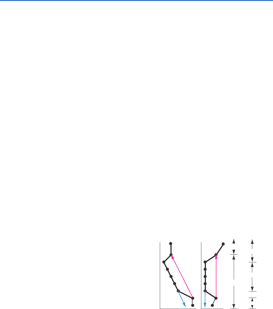
Large expanses of cold advection are evident in
the January climatological-mean chart shown in
Fig. 9.19. The most prominent of these are off the
coasts of Japan and the eastern United States, where
8
During wintertime cold air outbreaks, cold continental air flows over the warm waters of the Gulf Stream and Kuroshio currents, giv-
ing rise to locally strong fluxes of latent and sensible heat, as discussed in connection with Fig. 9.14.
Vg
3AM 9AM 3PM 9PM 3AM
0
V
BL
2
5
10
20
50
100
200
1000
2000
500
100
1000
200
50
Wind Speed, V
Time
Height,
z =
500
m
Fig. 9.18 Sketch of variation of wind speed (V) with local
time on a sunny day over land, as might be measured at dif-
ferent heights (2 m, 5 m, 10 m .... 2000 m) in the boundary
layer. V
g
is the geostrophic wind. V
BL
is the mixed layer wind
speed, as also sketched in Fig. 9.16. [Adapted from Meteorology
for Scientists and Engineers, A Technical Companion Book to
C. Donald Ahrens’ Meteorology Today, 2nd Ed., by Stull, p. 77.
Copyright 2000. Reprinted with permision of Brooks/Cole,
a division of Thomson Learning: www.thomsonrights.com.
Fax 800-730-2215.
15
W m
–2
–50 50 100 150 200 250 300 3500
Fig. 9.19 Climatological-mean January latent plus sensible
heat fluxes leaving the surface. [Based on data from data by
the European Center for Medium Range Weather Forecasting
40-Year Reanalysis. Courtesy of Todd P. Mitchell.]
P732951-Ch09.qxd 9/12/05 7:48 PM Page 395
396 The Atmospheric Boundary Layer
cold continental air flows over the warm western
boundary-currents (i.e., the Kurishio current and the
Gulf Stream, respectively). The combined sensible
and latent heat fluxes in these zones (indicated by
the colored shading in Fig. 9.19) are 300 W m
2
in
the climatological mean and they are even larger
and during cold air outbreaks. The trade wind belts,
where cool air is flowing equator-ward and west-
ward over progressively warmer water, also exhibit a
weakly unstable boundary-layer stratification and
enhanced sensible and latent heat fluxes.
Stably stratified marine boundary layers, with
vertical temperature moisture and wind profiles
analogous to the nighttime land profiles in Fig. 9.16,
are observed in regions of warm advection, where
warm air is flowing over colder water. For example,
as air that has resided over the Gulf Stream flows
northward over the cold Labrador Current to the
southeast of Nova Scotia (see Fig. 2.5) it becomes
stably stratified. Under these conditions, the air just
above the surface is often chilled to its dew point,
resulting in widespread fog. Advection fog is also
common when air approaching the coast of
California passes over the narrow zone of coastal
upwelling just offshore, and when warm, humid air
masses off the Gulf of Mexico flow northward over
snow-covered ground in the midwestern United
States during winter.
Over the Arctic and Antarctic, the boundary layer
becomes highly stratified in response to the uninter-
rupted radiative cooling of the surface during the
extended polar night. Under conditions of light winds,
boundary-layer turbulence virtually disappears and
the capping inversion settles to the ground. Under
these conditions the surface air temperature may be
more than 20 °C lower than the air temperature at
the top of the inversion just tens or hundreds of
meters above the ground.The surface air temperature
may rise sharply whenever the wind speed picks up,
mixing warmer air downward from above the inver-
sion or when a cloud layer moves overhead, increas-
ing the downward flux of longwave radiation incident
on the Earth’s surface.
During cold, calm intervals, Arctic cities and towns
such as Fairbanks, Alaska, experience episodes of ice
fog when water vapor emitted by automobiles and
wood stoves is trapped below the inversion. The frost
point of the air is so low that even the emissions from
a small urban complex are sufficient to supersaturate
the air, resulting in the formation of tiny, sparsely dis-
tributed ice crystals referred to by local residents as
“diamond dust” because of the way they sparkle in
the sunlight.
9.3.5 Nonlocal Influence of Stratification on
Turbulence and Stability
Based on the environmental sounding it is possible to
make inferences about the vertical distribution of tur-
bulence. In the analysis in Section 3.6, layers were
examined individually and judged to be convective or
nonconvective depending on the local stratification of
temperature and moisture. This approach yields use-
ful information in some cases, but it can sometimes
yield misleading results because it fails to take
account of the nonlocal character of turbulence.
For example, the local method would incorrectly
identify the middle of the mixed layer as statically neu-
tral (implying only moderate, isotropic turbulence and
coning of smoke plumes), as opposed to statically
unstable (strong turbulence, highly anisotropic, with
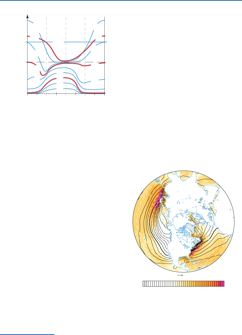
looping smoke plumes), as demonstrated in Fig. 9.20.
The analysis of soundings can be extended to
include non-local influences of stratification in the
following manner.
1. First, locate any statically unstable regions.
This is done by first plotting the
profile.
Then, from every relative maximum in
,a
environment
dry adiabat
parcel movement
stable
unstable
stable
stable
neutral
unstable
Height, z
T
θ
Correct
analysis
Incorrect
local
analysis
Fig. 9.20 Demonstration of how to properly determine static
stability by considering nonlocal air-parcel movement from the
relative maxima and minima in the potential temperature
sounding. T is air temperature. [Adapted from Meteorology for
Scientists and Engineers, A Technical Companion Book to
C. Donald Ahrens’ Meteorology Today, 2nd Ed., by Stull, p. 131.
Copyright 2000. Reprinted with permission of Brooks/Cole,
a division of Thomson Learning: www.thomsonrights.com. Fax
800-730-2215.]
P732951-Ch09.qxd 9/12/05 7:48 PM Page 396
9.3 Vertical Structure 397
Exercise 9.5 A rawinsonde sounding through the
lower troposphere gives the following profile infor-
mation. Which layers of air are turbulent, and why?
Solution: To determine the regions in which turbu-
lence is occurring we need to examine both dynamic
stability and nonlocal static stability. For dynamic sta-
bility, when the derivatives in Eq. (9.8) are approxi-
mated with finite differences, the result is called the
bulk Richardson number
where the angle brackets represent the average
across the whole layer. Also, use
T z, where
9.8 C km
1
is the dry adiabatic lapse rate.
The results are in the following tables:
T
v
R
B
T
v
v
z
(U)
2
(V)
2
z (km) T (°C) U (m s
1
)
(°C) T
avg
(k) z (m) U (m s
1
)
(K)
13 58 30 69.4
11 58 60 49.8 215.15 2000 30 19.6
8 30 25 48.8 229.15 3000 35 1.4
5 19 20 30 248.65 3000 5 18.4
3 3 18 26.4 262.15 2000 2 3.6
2.5 1 9 25.5 272.15 500 9 0.9
2 2 8 21.6 274.65 500 1 3.9
1.6 0 5 15.68 274.15 400 3 5.92
0.2 13 5 14.96 279.65 1400 0 0.72
0 18 0 18 288.65 200 5 3.04
z (km) T (°C) U (m s
1
)
13 58 30
11 58 60
8 30 25
5 19 20
3 318
2.5 1 9
228
1.6 0 5
0.2 13 5
0180
Assume V 0, q 0, and T
v
T.
conceptual air parcel is lifted adiabatically
until it hits the sounding again (or reaches
the highest altitude plotted, whichever is
lower). The altitude range from start to end of
this lift is statically unstable. Similarly, every
relative minimum in
is located, and a
conceptual air parcel is lowered until it hits
the sounding again (or hits the ground,
whichever is higher). This delineates
additional regions of unstable air.The total
domain of unstable air is the superposition of
all the unstable regions (see Fig. 9.20 for
example).
2. Next, for only those subdomains outside of the
unstable regions, identify as statically stable
those regions in which
z 0.
3. Finally, designate any remaining subdomains
as statically neutral (i.e., regions in which
z 0).
In cloudy regions, the nonlocal method is applica-
ble by changing from dry to moist adiabats when fol-
lowing rising air parcels above their LCL, and
changing from moist to dry adiabats when following
descending parcels below their LCL.
To determine regions of turbulence, regions of
statically unstable air must first be estimated, using
nonlocal methods as outlined earlier. Then the
Richardson number criterion discussed in Section
9.1.3 is used to identify regions of dynamically
unstable air. Finally, turbulence is expected in regions
that are statically or dynamically unstable. Laminar
flow is expected only where the flow is both statically
and dynamically stable.
P732951-Ch09.qxd 9/12/05 7:48 PM Page 397
398 The Atmospheric Boundary Layer
For static stability, plot the profile, and lift parcels
from every relative maximum and lower from every
relative minimum to identify statically unstable regions.
The layer z 0 to 1.8 km is statically unstable.
Layer (km) R
B
Dynamically Statically Turbulent
11 to 13 1.98 Stable Stable no
8 to 11 0.15 Unstable Stable yes
5 to 8 87.02 Stable Stable no
3 to 5 67.29 Stable Stable no
2.5 to 3 0.20 Unstable Stable yes
2 to 2.5 69.58 Stable Stable no
1.6 to 2 9.41 Stable Unstable to yes to
1.8 km 1.8 km
0.2 to 1.6 (undefined) Unstable yes
0 to 0.2 0.83 Unstable Unstable yes
Summary: The bottom turbulent region 0–1.8 km is
the boundary layer. Clear air turbulence (CAT) exists
near the jet stream, from 8 to 11 km.The other turbu-
lent region is 2.5 to 3 km. ■
9.4 Evolution
This section considers the processes that control the
depth of the boundary layer and cause it to evolve in
response to changing environmental conditions.
9.4.1 Entrainment
The capping inversion is not a solid boundary. Hence,
when rising thermals and turbulent eddies from the
mixed layer reach the capping inversion, the inertia
of the thermals and eddies causes them to overshoot
a small distance through the capping inversion
before sinking back into the mixed layer. During this
overshoot, the air inside these thermals and eddies
has temporarily left the mixed layer, and the pressure
gradient created by the incursion of the thermal into
the capping inversion drives wisps of free atmos-
phere air downward through the capping inversion to
take the place of the missing air in the mixed layer.
But this exchange is asymmetric.The thermals over-
shoot into a laminar region of air in the free atmos-
phere, where nothing prevents these thermals (in
which the air is lower in potential temperature than
the air in the free atmosphere) from sinking back into
the mixed layer. However, the wisps of free atmos-
phere air that were pushed down into the mixed layer
find themselves immediately torn and mixed into the
mixed layer by the strong turbulence there. These air
parcels become one with the mixed layer and never
return to the free atmosphere. This process is called
entrainment, and the layer in which it takes place is
called the entrainment zone. Entrainment occurs
whenever air from a nonturbulent region is drawn into
an adjacent turbulent region. It is a one-way process
that adds air mass to the turbulent mixed layer. It can
be thought of as a mixed layer that gradually eats its
way upward into the overlying air.
Figure 9.21 shows the typical evolution of the
boundary layer during fair weather over land in sum-
mer. By the end of the night, the boundary layer
often consists of a stably stratified shallow boundary
layer near the ground (called the noctural boundary
layer), above which is a nearly neutral layer called
the residual layer. Above that is the capping inver-
sion as was shown in Figs 9.15 and 9.16.
After sunrise, the warmed ground heats the air
touching the ground, creating shallow thermals that
E
.
Z
.
Day 1 Day 2Night 1
Free Atmosphere
Capping Inversion
Mixed
Layer
Residual
Layer
Stable
BL
Height, z
Fig. 9.21 Vertical cross section of boundary-layer structure
and its typical evolution during summer over land under fair-
weather, cloud-free conditions. E.Z. indicates the entrainment
zone. [Adapted from Meteorology for Scientists and Engineers, A
Technical Companion Book to C. Donald Ahrens’ Meteorology
Today, 2nd Ed., by Stull, p. 69. Copyright 2000. Reprinted with
permission of Brooks/Cole, a division of Thomson Learning:
www.thomsonrights.com. Fax 800-730-2215.]
0
4
8
12
020406080
Height, z (km)
Potential Temperature (°C)
Now we consider the dynamic stability using the
bulk Richardson number criterion.
P732951-Ch09.qxd 9/12/05 7:48 PM Page 398
9.4 Evolution 399
rise and cause intense mixing (creating the mixed
layer), and which cause entrainment at the top of the
mixed layer (in the entrainment zone). As the mixed
layer (or convective boundary layer) grows by entrain-
ment, it can “burn off” the nocturnal inversion and
then rapidly rise through the residual layer. Once it hits
the capping inversion, the entrainment zone becomes
the new capping inversion during the rest of the day.
Around sunset (Fig. 9.21), longwave radiation
cools the ground to temperatures less than the over-
lying air temperature, and two things happen.
1. Thermals cease, allowing turbulence to decay
in the former mixed layer.This former mixed
layer is now called the residual layer because
it contains the residual moisture, heat, and
pollutants, as was discussed in Fig. 9.16.
2. The cold surface cools the air near the ground,
transforming the bottom of the residual layer
into a gradually deepening, nocturnal stable
boundary layer.
Then the cycle repeats itself, day after day, as long as
the weather remains fair. In winter, when the nights
are longer than the days, the stable nocturnal bound-
ary layer is much thicker, and the daytime mixed layer
is so shallow that the top of the stable boundary layer
persists day and night as the capping inversion.
9.4.2 Boundary-Layer Growth
The mixed layer is not a closed system with a fixed
mass per unit area. It can incease in depth as air is
entrained into it from above, and it can increase or
decrease in depth in response to the large-scale verti-
cal velocity; that is
(9.27)
where w
e
is called the entrainment velocity (always
nonnegative), defined as the volume of air entrained
per unit horizontal area per unit time, and w
i
is the
vertical velocity of the large-scale motion field at the
top of the boundary layer (negative for subsidence).
Exercise 9.30 shows that
(9.28)
where { V} is the mass-weighted divergence within
the boundary layer. Over regions of fair weather, w
i
is usually downward (negative) and the horizontal
flow within the boundary layer is divergent.
w
i
z
i
{ V}
dz
i
dt
w
e
w
i
Divergence may be viewed as thinning the boundary
layer over a given region by removing air laterally.
Conversely, in regions of large-scale ascent, boundary
layer convergence thickens the boundary layer.
A strengthening of the turbulence in the mixed layer
causes greater entrainment, whereas a strengthening of
the capping inversion
reduces entrainment by
reducing the inertial overshoot of the thermals and
eddies. The rate of generation of TKE by buoyancy is
proportional to the surface sensible heat flux F
Hs
(in
kinematic units) so the entrainment rate for a free-
convective mixed layer is well approximated by
(9.29)
where
(9.30)
The so-called Ball parameter A is on the order of 0.2
for free convection and increases as more mechanical
turbulence adds to the entrainment.
The sensible heat flux across the capping inversion
F
Hzi
is usually negative because air with higher poten-
tial temperature from the free atmosphere is drawn
downward by entrainment.An idealized sensible heat-
flux profile under conditions of free convection is
shown in Fig. 9.22. The average potential temperature
A F
Hzi
F
Hs
w
e
A F
Hs
z
i
z
i
(a)
0
(b)
F
Hs
F
Hzi
0
Potential
Temperature,
θ
∆θ
Heat Flux, F
H
Height, z
Fig. 9.22 Typical (dashed) and idealized (solid) vertical pro-
files of potential temperature
and turbulent sensible heat
flux F
H
across the mixed layer. The idealized version is some-
times called a slab model (because of the uniform
in the
mixed layer) or a jump model (because of the discontinuity
in the entrainment zone). [Adapted from Meteorology for
Scientists and Engineers, A Technical Companion Book to
C. Donald Ahrens’ Meteorology Today, 2nd Ed., by Stull, p. 69.
Copyright 2000. Reprinted with permission of Brooks/Cole,
a division of Thomson Learning: www.thomsonrights.com.
Fax 800-730-2215.]
P732951-Ch09.qxd 9/12/05 7:48 PM Page 399
400 The Atmospheric Boundary Layer
in the mixed layer, , is warmed by both the upward
sensible heat flux from the surface and from the
downward entrainment heat flux at the top
(9.31)
The entrained air brings with it the heat, moisture,
pollutants, and momentum from the free atmos-
phere. The rates at which these scalar variables are
added to the boundary-layer air (per unit area) can
be represented as fluxes at the top of the mixed
layer. For example, for moisture
(9.32)
where q is specific humidity and q is the humidity
step across the mixed-layer top (q q
zi
q
zi
).
Subscripts zi and zi refer to just above and below
the entrainment zone, respectively. Equations analo-
gous to (9.32) can be written for any scalar variable,
including potential temperature and pollutants, and
is also used for the horizontal momentum compo-
nents u and v. When existing pollutants are mixed
down from elevated layers in the residual layer or
free atmosphere, the process is called fumigation.
Under light wind conditions it is possible to predict
the growth of z
i
in the diurnal cycle over land based
on the early morning temperature sounding and a pre-
diction of the surface sensible kinematic heat flux.
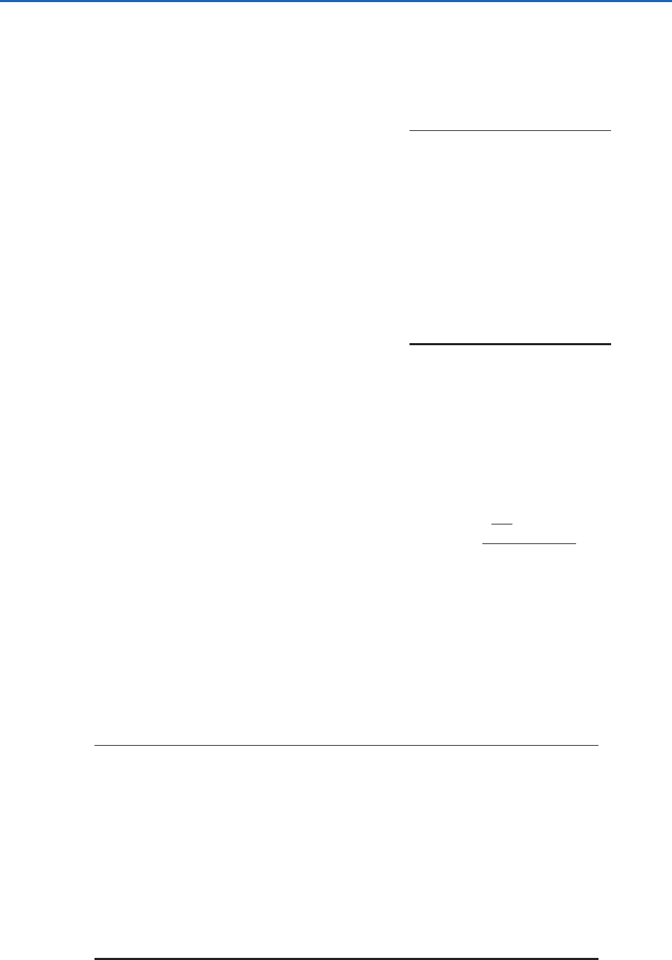
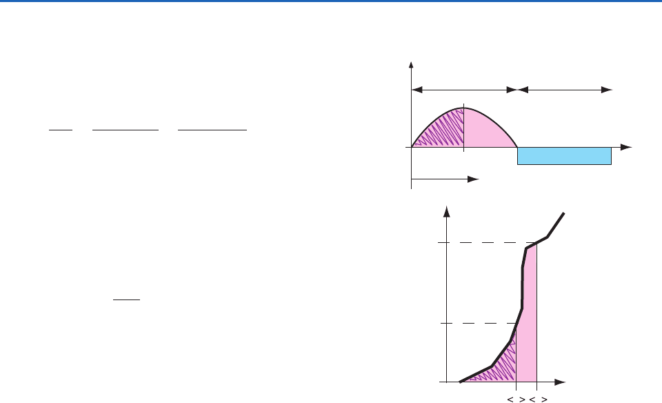
Figure 9.23a shows the idealized surface sensible heat-
flux evolution, which can be predicted based on a
knowledge of the day of the year (which determines
sun angles) and the expected cloud coverage. Between
the time shortly after sunrise when heat flux becomes
positive and the time of day of interest for determin-
ing z
i
, the amount of accumulated heating is the area
under the curve between those two times (the hatched
area in Fig. 9.23a). If advection is negligible, it can be
assumed that this heat warms the boundary layer.
Assuming an adiabatic temperature profile in the
mixed layer, the amount of heat needed to raise z
i
from the surface to the level it reaches at t t
1
is
the area under the sounding (the hatched area in
Fig. 9.23b). The solution is obtained by finding an
average potential temperature in the mixed layer,
, such that the hatched area under the sounding
curve equals the hatched area under the heat-flux
curve. Then, knowing , the mixed-layer depth z
i
is the height at which intersects the morningu
u
u
wq
w
e
q
d
dt
F
Hs
F
Hzi
z
i
(1 A)F
Hs
z
i
u
sounding. This procedure is called the thermody-
namic method or the encroachment method.
Exercise 9.6 (a) If the potential temperature pro-
file is linear in the stable boundary layer at sunrise,
derive an equation for the growth rate of the mixed
layer using the thermodynamic approach. For sim-
plicity, assume the surface heat flux is constant. (b)
How does the shape of this curve relate to the initial
mixed-layer growth phase?
Solution: (a) If the early morning sounding is
z
, and the surface kinematic heat flux is F
Hs
,
then the area under the heat-flux curve is A F
Hs
t,
0
Daytime Nighttime
F
Hs
t
1
t
2
Time, t
Heat Flux, F
H
z
i
at t
1
z
i
at t
2
0
θθ
θ
E
a
r
l
y
M
o
r
n
i
n
g
S
o
u
n
d
i
n
g
Height, z
Potential Temperature,
(a)
(b)
at t
2
at t
1
Fig. 9.23 (a) Idealized variation of surface sensible heat flux
F
Hs
(in kinematic units of K m s
1
) with time during fair weather
over land. The area indicated by the hatched region represents
the total amount of heat input into the bottom of the boundary
layer from sunrise until time t
1
. (b) Typical early morning sound-
ing (heavy line) of potential temperature,
, showing the change
in the mixed-layer average potential temperature, , and depth
z
i
with time t. The hatched area in (a) equals the hatched area
in (b). [Adapted from Meteorology for Scientists and Engineers, A
Technical Companion Book to C. Donald Ahrens’ Meteorology
Today, 2nd Ed., by Stull, p. 70, 74. Copyright 2000. Reprinted
with permission of Brooks/Cole, a division of Thomson
Learning: www.thomsonrights.com. Fax 800-730-2215.]
u
P732951-Ch09.qxd 9/12/05 7:48 PM Page 400
9.4 Evolution 401
where t is time since sunrise. The area under the
sounding is a triangle, yielding A (
)
2
(2
),
where
is the amount of warming of the mixed
layer since sunrise, assuming, as initial conditions,
that z
i
0 at sunrise. Equating the two areas gives
(2
F
Hs
t)
12
. Because the morning profile is lin-
ear, z
i
. Thus, z
i
[(2F
Hs
) t]
12
.
(b) The square root of time dependence from part (a)
does not agree with the square of time dependence
typically observed in the early morning, as plotted in
Fig. 9.24. The difference is due to the fact that during
the morning the heat flux is not constant with time, but
increases sinusoidally, and also that the initial vertical
profile of potential temperature is not linear, but is
exponential in shape as in Fig. 9.16b. ■
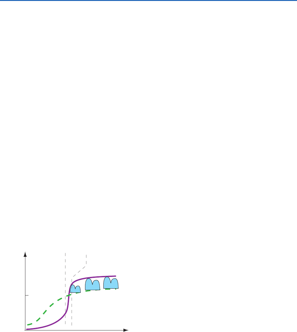
9.4.3 Cloud-Topped Boundary Layer
over Land
The lifting condensation level (LCL) can be below z
i
on days when sufficient moisture is present in the
boundary layer. In this case, the tops of the thermals
that extend above the LCL are filled with cumulus
clouds. During fair weather regimes over land, the
cloudless boundary layer top typically rises slowly dur-
ing the morning, while the noctural inversion from the
previous night is being “burned off.” In contrast, the
LCL rises rapidly during the morning due to warming
of the air near the surface, which lowers the relative
humidity.Thus, the sky typically remains free of bound-
ary-layer clouds through mid-morning because the
LCL stays above the top of the rising boundary-layer.
By late morning, the boundary layer typically expe-
riences a rapid-rise phase after the nocturnal inver-
sion has completely disappeared (Fig. 9.24).
At around this time, z
i
jumps to the height of the cap-
ping inversion from the day before (often 1 or 2 km
altitude), and becomes higher than the LCL. This is
the time when fair-weather cumulus clouds are most
likely to form. The degree of vertical development of
the clouds depends on the height difference between
the LCL (which marks the cloud base) and z
i
(which
marks the cloud top). These fair-weather cumulus
clouds are distinguishable from the clouds associated
with deep convection (see Section 8.2) because they
do not penetrate beyond the top of the capping inver-
sion into the free atmosphere. The level of the cloud
top is the height to which thermals rise from the sur-
face, and the height to which water vapor and pollu-
tants from the surface are rapidly mixed.
Sometimes, if there is sufficient vertical wind shear
V
z in the mostly convective boundary layer, weak
parallel counterrotating pairs of circulations form,
which are called horizontal roll vortices (or “rolls” for
short). The axes of rotation of the rolls are oriented
roughly parallel with the mean wind direction, and
the diameter of each roll is of the same order as the
boundary-layer depth (Fig. 9.25a). These overturning
circulations are almost too weak to measure, but they
organize the stronger thermals into parallel lines
with a spacing equal to roughly twice the boundary-
layer depth. When sufficient moisture is present to
support the formation of cumulus clouds, the rolls
are visible as parallel rows of cumulus clouds called
cloud streets, which are apparent in satellite images
(Fig. 9.25b) and sometimes from the ground as well.
9.4.4 The Marine Boundary Layer
The cloud-topped boundary layer over the oceans
tends to be different from its land counterpart in the
following respects,
• Relative humidities of the surface air tend to be
higher (usually in excess of 75%).
• Because of the higher relative humidity of the
air, cloud cover (much of it in the form of stratus
and stratocumulus cloud decks) is much more
sunrise mid-morning mid-afternoon
LCL
z
i
~1
km
Phase 1
Nocturnal
Inversion
Burn-off
Phase 2
Rapid
Rise
Phase 3
Quasi-
steady
clouds
Height, z
Fig. 9.24 Three-phase growth of mixed layer depth z
i
during
fair weather in daytime over land showing the height to which
thermals can rise. Corresponding variation in the lifting con-
densation level (LCL) showing the heights needed by thermals
to rise to produce cumulus clouds. When z
i
LCL, the
LCL marks the cloud base of convective clouds. [Adapted
from R. B. Stull, An Introduction to Boundary Layer Meteorology,
Kluwer Academic Publishers, Dordrecht, The Netherlands,
1988, Fig. 11.10, p. 452, and Fig. 13.12, p. 564, Copyright
1988 Kluwer Academic Publishers, with kind permission of
Springer Science and Business Media.]
P732951-Ch09.qxd 9/12/05 7:48 PM Page 401
402 The Atmospheric Boundary Layer
extensive. Some oceanic regions are cloud
covered most of the time.
• With the widespread presence of clouds,
radiative transfer plays a more important and
more complex role in the boundary-layer heat
balance.
• In some regions, drizzle plays a significant role in
the boundary-layer heat and water balance.
• The diurnal cycle is not as important and is
governed by entirely different physics.
The presence of a cloud layer tends to strengthen
the capping inversion through its impact on the radi-
ation balance of the underlying layers (i.e., the ocean
plus the atmospheric boundary layer).
9
The strength-
ening of the capping layer, in turn, reduces the
entrainment of dry air into the cloud layer, thereby
contributing to the maintenance of the cloud deck.
Once formed, marine cloud decks tend to persist
because of this positive feedback.
In the cloud-topped boundary layer, convection
may be driven by heating from below or by cooling
from above. The heating from below is determined by
the surface buoyancy flux (i.e., the sensible heat flux
and the moisture flux to the extent that it affects the
virtual temperature) as in the diurnal cycle over land.
The cooling from above is determined by the flux
of longwave radiation at the top of the cloud layer
(see Fig. 4.30). Heating from below drives open cell
convection (Figs. 1.21 and 9.26), with strong, con-
centrated, buoyant, cloudy plumes interspersed with
more expansive regions of weak subsidence that are
cloud-free. In contrast, cooling from above drives
closed cell convection (Figs. 1.7 and 9.26) with strong,
negatively buoyant, cloud-free downdrafts, inter-
spersed with more expansive regions of slow ascent
(a)
Fig. 9.25 (a) Vertical cross section through the ends of a laboratory simulation of horizontal roll vortices showing the counter-
rotating circulations. [From “Influence of Initial and Boundary Conditions on Benard Convection,” H.Oertel, Jr., and
K. R. Kirchartz, in Recent Developments in Theoretical and Experimental Fluid Mechanics: Compressible and Incompressible
Flower, U. Muller, K. G. Roesner, B. Schmidt, eds., Fig. 1, 1979, p. 356, Copyright Springer-Verlag, Berlin, 1979. With kind
permission of Springer Science and Business Media.] (b) View looking down on streets of cumulus clouds aligned into rows by
the horizontal roll vortices. [NASA MODIS Imagery.]
(b)
9
Where the boundary layer is shallow , the reduction in insolation due to the presence of the cloud deck far outweighs the
reduction in outgoing longwave radiation from the underlying water because the cloud top is not much cooler than the underlying sea sur-
face. The net effect is radiative cooling of the mixed layer, which helps maintain clouds by keeping the relative humidity high. For bound-
ary-layer depths 2 km the two effects nearly cancel and the cooling is less efficient.
(z
i
1 km)
P732951-Ch09.qxd 9/12/05 7:48 PM Page 402
9.4 Evolution 403
that are cloudy. When satellite images of closed cell
convection are rendered as negatives they resemble
images of open cell convection, and vice versa. Under
conditions of light winds, closed cell convection may
assume the form of polygonal cells like those in a
honeycomb.
In regions of strong large-scale subsidence where
the boundary layer is shallow (i.e., 500 m–1km in
depth), convection-driven heating from below and
cooling from above intermingle to form a unified tur-
bulent regime that extends through the depth of the
boundary layer.As the boundary layer deepens there
is a tendency for the two convective regimes to
become decoupled. The lower regime, driven by
heating from below, is restricted to the lower part of
the boundary layer. As in the daytime boundary
layer over land, it may be capped by cumulus clouds.
The capping layer of the upper, radiatively driven
regime coincides with the top of a more continuous
stratus or stratocumulus cloud deck. The lower and
upper regimes are typically separated by an interme-
diate quiescent layer in which the lapse rate is condi-
tionally unstable. If the cumulus convection in the
lower regime becomes sufficiently vigorous that air
parcels reach their level of free convection, these
buoyant thermals may rise high enough to entrain sig-
nificant quantities of dry air from above the capping
inversion, leading to the dissipation of the stratiform
cloud deck and reunification of the turbulent layers.
We can envision the aforementioned sequence
of events as occurring if we follow a hypothetical
column of boundary-layer air along an equatorward
trajectory along the coasts of California, Chile, or
Namibia that later curves westward in the trade
winds. In response to a weakening of the large-scale
subsidence, the boundary layer deepens, and cumulus
clouds appear below the base of the stratocumulus
deck. The cumulus clouds deepen until they begin to
penetrate through the overlying cloud deck. As if by
magic, the dreary cloud deck thins and dissipates,
leaving behind only picturesque trade wind cumulus.
Drizzle falling from the cloud deck and evaporat-
ing into the unsaturated air below it also affects the
boundary-layer heat balance. The condensation of
water vapor within the cloud deck releases latent
heat, and the evaporation of the drizzle drops in the
subcloud layer absorbs latent heat. The thermody-
namic impact of the downward, gravity-driven flux of
liquid water is an upward transport of sensible heat,
thereby stabilizing the layer near cloud base.
Low-level cold advection contributes to the main-
tenance of stratiform cloud decks in two ways: it
destabilizes the surface layer, thereby enhancing the
flux of water vapor from the sea surface, and it cools
the boundary layer relative to the overlying free
atmosphere, thereby strengthening the capping
inversion and reducing the entrainment of dry air.
The subsidence that usually accompanies cold
advection also favors a shallow boundary layer with
a strong capping inversion. Hence cloud-topped
boundary layers prevail in regions of climatological
mean cold advection (e.g., to the east of the subtrop-
ical anticyclones) and fractional cloud coverage in
these regions varies in synchrony with time varia-
tions in the strength of the cold advection.
In regions in which the marine boundary layer is
topped by cloud decks, fractional cloud coverage
tends to be highest around sunrise and lowest during
the afternoon. The thinning (and in some cases the
breakup) of the overcast during the daytime is due to
the absorption of solar radiation just below the cloud
tops (see Fig. 4.30). The heating at the top of the
cloud deck results in a weakening of the convection
within the upper part of the boundary layer, reducing
the rate at which moisture is supplied from below.
The moisture supply becomes insufficient to replen-
ish the drizzle drops that rain out, and the cloud
thins. The warming of the air at the cloud-top level
also increases its saturation mixing ratio, thereby
allowing some of the liquid water in the cloud
droplets to evaporate. After the sun goes down, the
air at cloud-top level cools in response to the contin-
uing emission of longwave radiation. In response to
the cooling, the convection resumes, renewing the
Fig. 9.26 Satellite photograph of mesoscale cellular convec-
tion. Open cells are in the upper-left and lower-right quad-
rants, and closed cells are elsewhere. [Courtesy of NASA
MODIS imagery.]
P732951-Ch09.qxd 9/12/05 7:48 PM Page 403