Potter T.D., Colman B.R. (co-chief editors). The handbook of weather, climate, and water: dynamics, climate physical meteorology, weather systems, and measurements
Подождите немного. Документ загружается.


CHAPTER 37
CONSEQUENCE OF INSTRUMENT
AND SITING CHANGES
JOSEPH W. SCHIESL AND THOMAS B. MCKEE
1 INTRODUCTION
In 1984, the National Weather Service (NWS) began the deployment of the H083 as
the standard operational hygrother mometer in use at approximately 400 NWS and
Federal Aviation Administration (FAA) field stations across the United States. The
data are used in support of aircraft operations at airports and by NWS meteorologists
for forecasting.
The purpose of the H083 was to measure temperatures at airports where the
required accuracy was 1
C (1.8
F) at temperatures between 50 and 50
C
(58 and 122
F). This was also the aviation standard of the World Mete orological
Organization (WMO). Even though these instruments at airports were not meant to
meet climatological requireme nts (there are separate networks for those), some
people use these data as an index of change for the local area. In addition, airports
are notoriously poor for climatological measurements because of the solar absorp-
tion characteristics of runways and roads plus the heating effects of buil dings and
moving aircraft. See Figure 1. It is important and even critical to determine these
heating factors since they are essential in computing aircraft takeoff distance.
2 EARLY MODIFICATIONS
Improvements were made to the H083 since its initial deployment to improve its
accuracy, reliability, maintainability, and to correct several deficiencies that were
identified after long-term exposure in a field environment.
Handbook of Weather, Climate, and Water: Dynamics, Climate, Physical Systems, and Measurements,
Edited by Thomas D. Potter and Bradley R. Colman.
ISBN 0-471-21489-2 # 2003 John Wiley & Sons, Inc.
747
The improvements were concentrated in four areas: (1) an optical block,
(2) board=connector corrosion resistance, (3) a new mirror, and (4) aspirator housing
and aspirator improvements. See Figures 2 and 3.
The sensor assembly was constructed with an optical block, which was devised to
simplify factory alignment and eliminate field misalignment of the electro-optical
components during mirror cleaning. The electro-optical components of the dew-
point sensor were previously soldered to a circuit board and were aligned at the
factory by bending the component leads into position. These components are now
rigidly mounted in an optical block assembly, which ensures precise component
alignment relative to the reflective mirror surface. However, it is important that
the optical loop calibrati on procedures be followed correctly. Electronic readings
must be allowed to settle. This is easy to say but difficult to do in subzero
temperatures or other inclement weather conditions.
The redesign of the new sensor assembly and the use of new fabrication techni-
ques eliminated the formation of corrosion on the sensor board. Corrosion on the
sensor assembly, especially in the vicinity of the connector, can result in electrical
leakage paths on the printed circuit boards in high-humidity conditions. This leakage
can lead to erroneous calibration and simulated temperature diagnostics, incorrect
temperature readings, and, eventually, complete failure of the sensor. The new design
featured a hand-w ired, potted connector whose pigtails are soldered to plated-
through holes on the sensor board. Printed wiring circu its on the boards were
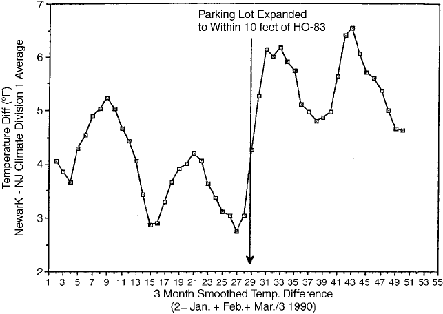
Figure 1 Temperature difference between Newark, New Jersey, airport, and surrounding
climate stations. Note the change coincident with the parking lot expansion.
748
CONSEQUENCE OF INSTRUMENT AND SITING CHANGES
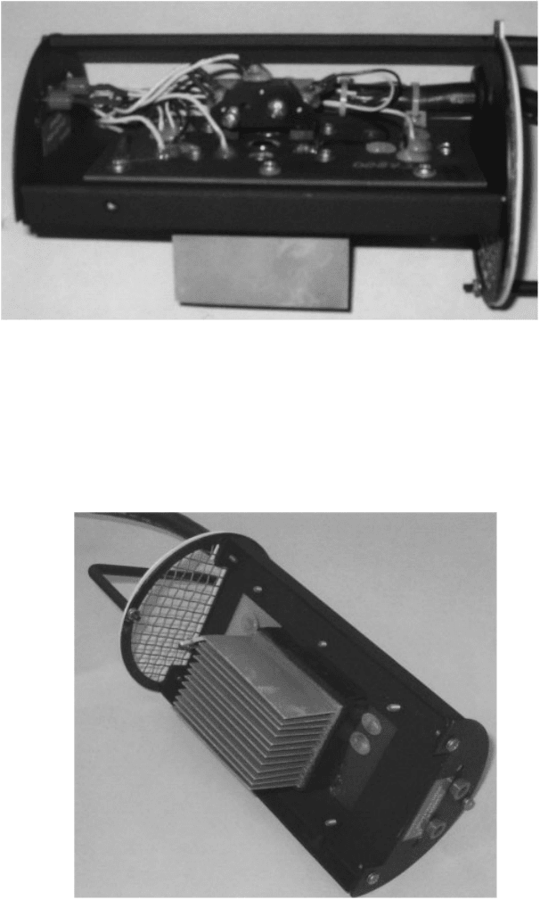
Figure 3 Peltier device on back side of sensor board. The aspirator would be located at the
end of the sensor board toward the upper left in the figure.
Figure 2 Hygrothermometer sensor board. Pyramid shaped object is the optical block. A
round mirror is beneath the optical block. Peltier device is below the mirror on the opposite
side of the sensor block (See Fig. 3).
2 EARLY MODIFICATIONS 749
virtually eliminated and the board was manufactur ed with a protective solder mask
coating.
The new dew-point mirror was designed to provide proper operation with the
optical block and to extend the life of the mirror surface. The mirror life was
extended by improving fabrication techniques, including thorough cleaning prior
to plating and using improved precision plating technology.
Consistency is critical for the components in the optical loop. Variations in the
mirror, light-emitting diodes, and phototransistors cause calibration errors especially
at high and low temperatures. Combinations of inconsistency, corrosion, excessive
contaminants, improper cleaning, and calibration result in mirror icing.
The H083 aspirator=housing modifications were designed to minimize the effects
of solar heating of the aspirator. The first modi fication was a ‘‘top hat’’ for the
hemispherical part of the aspirator, which provided for an inch of expanded poly-
styrene insulation and additional shading of the stem. The second modification
provided increased airflow through the aspirator by decreasing the airflow restric-
tions on the temperature side of the aspirator.
3 NEW CONCERNS
While plans were being made to do validation testing of the redesigned sensor and
aspirator before deployment in the field, another concern surfaced. In July, 1989,
meteorologists at the University of Arizona expressed concern about anomalous
high-temperature readings at Tucson Airport. The Tucson Airport was breaking
numerous records. Scientists at the National Climatic Data Center confirmed a
warm bias at Tucson but also stated that they did not see this bias in other parts
of the country.
At this point, NWS management established a Hygrothermometer Working
Group (HWG) to investigate this problem and come up with an appropriate solution.
The HWG was composed of meteorologists and engineers from the government,
academia, and the manufacturer. To determine the extent of the problem, a survey of
the weekly temperature comparisons around the country was conducted. The results
showed that only Tucson was out of specifications, but there was definitely a warm
bias in the Southwest on days with low winds and high solar radiation.
Tests conducted in the spring and summer of 1990 by NWS’s Equipment Test and
Evaluation Branch in Sterling, Virginia, indicated that the H083 was susceptible to
solar-radiation-induced er rors that could approach 1.7
C (3.0
F) under certain low
wind speed conditions. While errors of this magnitude were acceptable in the H083
temperature specification as it existed at that time, steps were taken to improve the
accuracy of the hygrothermometer.
The next task of the HWG was to clarify the H083 temperature specification.
The original H083 requirements were for an accuracy of 0.5
C (0.9
F) root-mean-
squared error (rmse) based on monthly computations, a maximum error of 1.0
C
(1.8
F), and 95% of the monthly data should be less than the specified errors. The
revised H083 temperature specification was also adopted for the model 1088 hygro-
750 CONSEQUENCE OF INSTRUMENT AND SITING CHANGES
thermometer, also known as the Automated Surface Observing System (ASOS)
hygrothermometer. The new specification, requires an accuracy of 0.5
C (0.9
F)
rmse (computations based on 7 days of data) and an absolute maximum error of
1.0
C (1.8
F). These requirements were for temperatures between 50 and 50
C
(58 and 122
F). The rmse and absolute errors were doubled for temperatures
outside this range down to 62
C(80
F) and up to 54
C (130
F). The 95%
requirement was deleted, which tightened the accuracy requirements significantly.
Through the preliminary testing, all hygrothermometer testing had been done at
Sterling. The HWG decided that concurrent testing should be conducted at addi-
tional field sites to determine whether the solar-radiation-induced errors seen at
Sterling were representative of those that would be expected under worst-case condi-
tions. It was decided to conduct the initial field testing at Tucson, Arizona. First,
there was an interest in the hygrothermometer readings at Tucson. Second, Tucson is
in a climatological area where we expected meteorological conditions to be most
conducive to maximum solar-radiation-induced errors—high solar radiation with
low winds that occur during portions of spring and again in late summer.
Besides Tucson, the group decided to test the modifications in the north central
(Sault Ste. Marie, Michigan) and the southeastern (Daytona Beach, Florida) part of
the country for the extremes of temperature, humidity, and solar radiation, both
direct and indirect. Soon after this, another test site was established at the Ocean
City, Maryland, airport because of its proximity to the Atlantic Ocean. This site
proved valuable for accelerated corrosion testing.
The H083s that incorporated the early modifications were field tested at Sterling
in late 1990 and early 1991 and were found to meet the improved H083 accuracy
requirements. Based on these data, the HWG decided to validate the modifications in
Tucson. A field test bed was install ed in April, 1991, but it was soon evident that
solar loading =wind conditions in Tucson contr ibuted to errors that exceeded the
accuracy specification.
The group then undertook the task of working to reduce the amount of solar-
induced temperature measurement error. Several system modifications were made to
insulate the temperature probe from solar heating and improve aspiration through the
sensor assembly. Preliminary results showed a dramatic improvement in sensor
performance.
4 INITIAL TUCSON TEST RESULTS
A prototype of a modified H083 sensor (mod 1) was installed in the Tucson,
Arizona, test site on June 24, 1991. Mod 1 had a larger fan with approximately
three times the airflow capacity of the earlier version. In addition, the flow direction
was reversed. The reversal was made to minimize the heating of the ambient air by
the sensor housing itself. Data, during days of high solar loading, showed the
average solar-induced temperature rise to be approximately 0.6
C (1.0
F) versus
the 1.1 to 1.7
C (2.0 to 3.0
F) for the early double domed insulated hat, and 1.7
4 INITIAL TUCSON TEST RESULTS 751
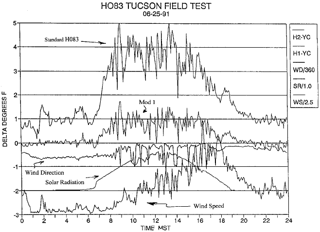
to 2.8
C (3.0 to 5.0
F) for the standard H083. See Figure 4. These deltas are all in
comparison to the Young aspir ated precision reference thermometer.
Even though good progress was made in solving the solar loading problem in the
Southwest, the HWG was not in a position to firmly state that the problem was
solved. The final modification had to be tested through the four seasons and in the
different climatological regimes that were chosen. Since the temperature sensor was
now located at the bottom of the instrument at the aspirator inlet, the group had to be
certain the sensor was protected from any albedo effect either off snow or a natural
reflective soil typified at Tucson, Arizona. Also, the HWG had to make sure the
minimum temperatures were not affected or more importantly the dew point. Tucson,
Arizona, with its temperature–dew-point depressions reaching 47
C (85
F), repre-
sents only one end of the humidity spectrum.
5 OVERALL TEST RESULTS
While the HWG was evaluating the solar loading modifications, it be came apparent
that there were a number of other problems with the H083. During temperature bath
Figure 4 Comparison between standard H083 and Mod 1 at Tucson, Arizona. Mod 1 has a
larger fan with approximately three times the air flow of the standard H083 and the flow
direction has been reversed. Temperature deltas (
F) are in comparison to the Young reference
sensor.
752
CONSEQUENCE OF INSTRUMENT AND SITING CHANGES
calibration tests, calibration errors were found that varied from 0.8 at 54
C to 1.2
at 51
C(1.5 at 130
F to 2.1 at 60
F). It was also found during calibration
stability tests that the sensor calibration drifted excessively with temperature, which
would affect the actual sensor accuracy in the operational mode. These performance
characteristics add a large degree of uncertainty to interpretation of H083 field
performance test data. The problems were serious enough to suspend field testing
during November and December of 1991.
Based on testing conducted in late December, 1991, and early January, 1992, the
HWG determined that the latest modified sensor now had more stable electronics
and deployed these modifications at the field test sites.
Both the standard and modified systems were installed at Tucson, Sault Ste. Marie,
Daytona Beach, Ocean City, and Sterling. The HWG was able to measure not only
the instrumental biases at these diverse climatological sites but also could determine
why the biases occurred. This was possible because pyrheliometers, wind sensors,
and reference temperature sensors were installed and carefully calibrated at each site.
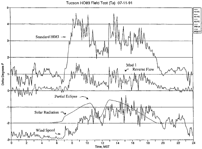
The effects of a partial solar eclipse were captured on both systems, which clearly
demonstrated the solar loading problem. See Figure 5. These test beds were set up to
determine the temperat ure biases between the different sensors under different wind
and solar loading conditions. The resolution of the data was in minutes, rather than
by the hour or the daily maximums and min imums presented in previous studies.
Having a calibrated standard at each site also allowed the determination of how
Figure 5 Similar to Fig. 4, but with a partial solar eclipse.
5 OVERALL TEST RESULTS 753
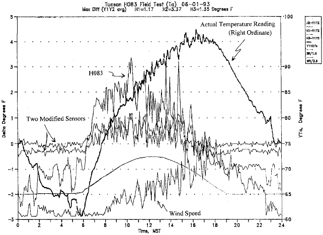
much each sensor differed from an established reference, rather than just stating the
difference between the standard and modified systems. See Figure 6.
6 AN OVERCONSER VATIVE DATA QUALITY CHECK
Of all the ASOS sensors, the hygrothermometer generated the most data quality
failures. These failures generally indicate that the data coming from the sensor are
suspicious. This suspicion can be caused by an internal self-test or the data quality
algorithms. One of the processes initiat ed by this failure is the setting of the main-
tenance character ($) in all future observations that can only be cleared via the
technician interface. In the case of the hygrothermometer, the data quality algorithm
is the main cause of quality failures.
The ASOS hygrothermometer continually measures the ambient temperature and
provides sample values about six times per minute. Processing algorithms in the
hygrothermometer use these samples to deter mine a 1-min average temperature valid
for a 60-s period ending at Mþ00 (minute þ 00 seconds). Once each minute the
5-min average temperature is calculated from the 1-min average observations. These
5-min averages are rounded to the nearest degree Fahrenheit, converted to the nearest
0.1 degree Celsius, and reported once each minute as the current 5-min average
temperature.
Figure 6 Similar to Fig. 4, but with two modified sensors.
754
CONSEQUENCE OF INSTRUMENT AND SITING CHANGES
A number of data quality checks are performed by an acquisition control unit,
including a rate of change check. Originally, if the current 1-min temperature
differed from the last respective, nonmissi ng, 1-min reading within the previous
2 min by more than 3.3
C (6.0
F), it is marked as missing. If there are less than
four valid 1-min average temperatures within the past 5 min, then the current 5-min
average temperature is not computed. In this case, ASOS will use the most recent
5-min average calculated temperature within the last 15 min. If no valid 5-min
average temperat ure is available within the last 15 min, a sensor failure is indicated.
The 15-min delay allows for a once-a-day calibration heat cycle to occur without
causing a data quality flag.
This initial rate turned out to be too conservative for the way the atmosphere was
behaving. Many meteorologists were naturally skeptical of large temperature
changes over short time periods for a number of reasons. Forty to 50 years ago,
with the limited data available, it was envisioned that temperature fluctuations of
more than two or three degrees Fahrenheit per minute were very rare events. High-
resolution temperature data in both space and time from mesonetworks were not
generally available. Thermographs were available, but their limitations will be
discussed later.
Experience reinforced this conservative view of temperature changes. Most times,
forecasters only saw the hourly weather reports where larger temperature rates were
smoothed out. Observations in between the hourlies (specials) that were generated
by significant changes or the onset or cessation of other meteorological elements did
not even require the recording of temperature and dew point.
Those who examined thermograph traces saw more drastic changes over time, but
these too were muted. In our efforts to protect the sensor from the elements as well as
the sun or other radiating surfa ces, we used thermometer screens. These lengthened
the response time.
This conservative view was in contrast to some records that were available. For
example, the following extraordinary events are noteworthy. There was the temporal
change in the surface temperature on January 22, 1943, at Spearfish, South Dakota,
from 20 to 7
C(4to45
F) in 2 min, which was caused primarily by a Chinook
wind. Then there were the spatial differences caused by cold air collecting in the
hollows on low-wind nights. This was dramatized by the car ride by Middleton and
Millar through Toront o in 1936 that showed differences of 14
C (26
F) over a mile.
Then there was the way thermometers were read. Temperatures and wet bulbs at
airport stations were read to tenths of degrees primarily for the computation of the
dew point and humidity. At low temperatures, a difference of only a few tenths in
wet-bulb depressions may mean differences of relative humidity of about 10%.
Temperatures can be measured electronically to a resolution of a thousandth of a
degree; however, in meteorological applications this is meaningless.
In the late 1960s, with the advent of automated and telemetered data systems like
the Automatic Hydrologic Observing System (AHOS), data were taken at 1-min
intervals. More abrupt changes in hydrometeorological data became evident.
Subsequent development of automated systems that also transmit data based on
rate and threshold algorithms, such as the Automatic Remote Collector (ARC) in
6 AN OVERCONSERVATIVE DATA QUALITY CHE CK 755
