John T. Sample, Elias Ioup. Tile-Based Geospatial Information Systems
Подождите немного. Документ загружается.

166 10 Map Projections
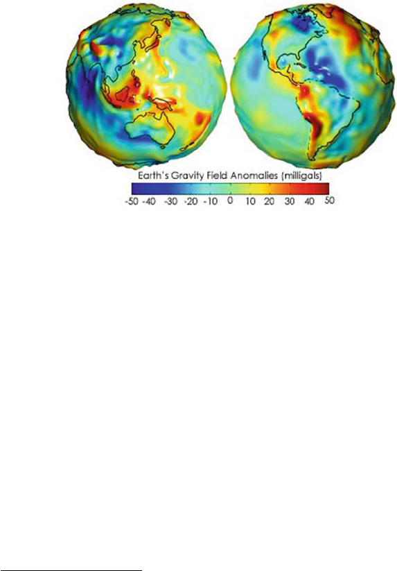
Earth. Figure 10.1
1
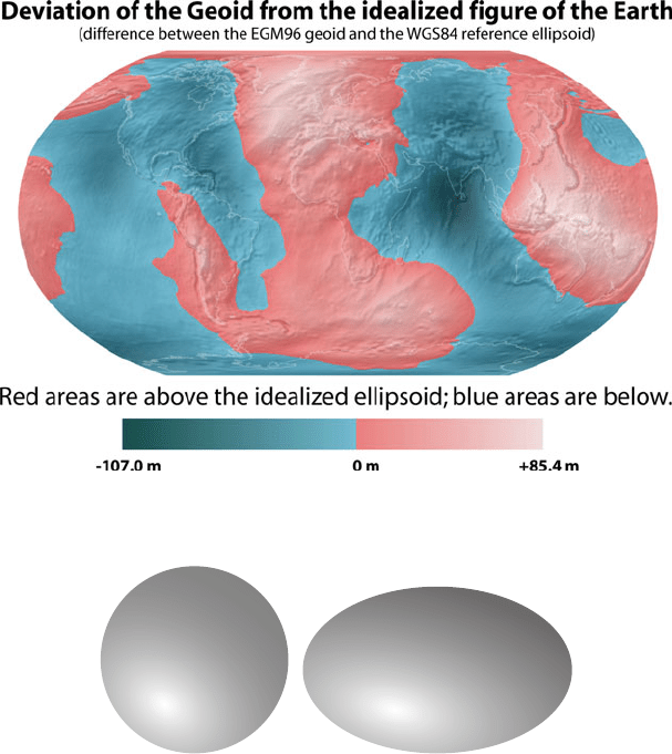
shows gravity variations over the Earth’s surface. Figure 10.2
2
shows the variations between the geoid and the most common approximation of the
shape of the Earth. The earliest approximations of the geoid used a sphere as the
shape of the Earth. In fact, a sphere is often used today to approximate the shape
of the Earth. The errors of a spherical approximation are not visible at whole Earth
scales.
Fig. 10.1 Gravity variations over the surface of the Earth.
A sphere is not the best approximation of the Earth because of flattening at the
poles. Instead, the best approximation is the elliptical analog to a sphere, called
either an ellipsoid or spheroid (see Figure 10.3). A number of different ellipsoid
approximations are currently in use. Different ellipsoids may provide better approx-
imations for specific areas of the Earth. There are also a number of ellispoids which
have been superceded but still can be found in older maps or measurements.
10.1.2 Datums
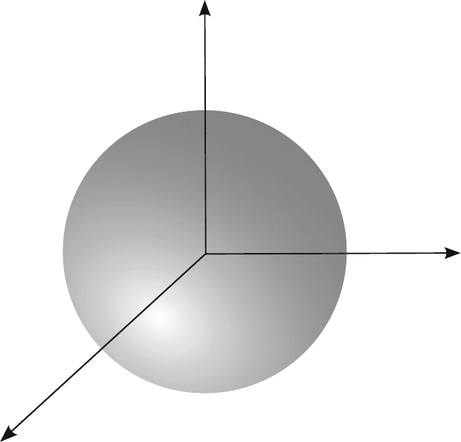
Individual ellipsoids are often referred to in the context of a datum. A datum is
an ellipsoid along with an origin point from which locations are referenced (see
Figure 10.4). Datums may be global and cover the entire Earth, or they may be local
and designed for mapping over a very small area. We are most interested in global
datums for the purpose of tile-based mapping; however, it is possible that a local
datum will be encountered in source data. Converting between datums is possible,
1
Courtesy of NASA. http://earthobservatory.nasa.gov/Features/GRACE/
page3.php
2
http://commons.wikimedia.org/wiki/File:Geoid_height_red_blue.png
10.1 Introduction to Datums, Coordinate Systems, and Projections 167
Fig. 10.2 Deviation of the geoid from the shape of the most commonly used ellipsoid approxima-
tion.
(a) Sphere (b) Ellipsoid
Fig. 10.3 The sphere and ellipsoid are commonly used as approximations for the shape of the
Earth. The above ellipsoid has an exaggerated flattening to highlight its shape. Earth approximating
ellipsoids visually resemble a sphere because they have only a small amount of flattening.
and the references at the end of the chapter are a good starting point if information
on how to perform the conversions is necessary.
The most commonly used datum is the World Geodetic System 1984, commonly
abbreviated WGS84. The WGS84 datum has a corresponding ellipsoid that provides
a good approximation for the entire Earth. While locally oriented ellipsoids will
provide better approximations for small areas, the WGS84 ellipsoid was designed
to be a “best fit” for the entire Earth. The origin for the WGS84 datum is the center
of the Earth, rather than a point on the surface as is common for many local datums.
This geocentric origin is necessary for satellite systems to use the datum.
168 10 Map Projections
Fig. 10.4 A datum is both an approximation for the Earth’s shape as well as an origin.
As stated above, WGS84 is by far the most commonly used datum for geospatial
data. Most source data used in a tile-based mapping system will use the WGS84
datum. Some exceptions are the NAD27 or WGS72 datums, both obsolete datums
once in use in the United States. The only reason to use a local datum is when a
mapping application requires greater local geoid accuracy than the WGS84 ellipsoid
can provide. This level of accuracy is rarely needed in a tile-based mapping system.
On the other hand, the WGS84 datum provides the most compatibility with other
software applications and data sources. Interoperability is an increasingly important
component of mapping systems. Thus, in most cases, a tile-based mapping system
should always use the WGS84 datum for native backend-data. The added benefit of
using WGS84 is that it is so common that most data will already be in this datum
with no additional work [2].
10.2 Map Projections 169
10.1.3 Coordinate Systems
Once a datum is selected to represent the shape the Earth, a coordinate system must
be defined to specify locations on its surface. There are two coordinate system types
in use today. The first is the commonly used geographic coordinate system which
uses latitude and longitude to specify a location. Geographic coordinates are a basic
angular coordinate system, either over a sphere or ellipsoid depending on which
approximation is used. The latitude is the angle north or south from the equator in
the range -90 to 90 degrees. The longitude is the angle east or west from the Central
(Greenwich) meridian in the range -180 to 180 degrees.
An alternate way of specifying locations on the surface of the Earth is with rect-
angular coordinates. Rectangular coordinates are a Cartesian coordinate system with
X and Y coordinates to represent horizontal and vertical position, respectively. Be-
cause a Cartesian coordinate system is used for a two-dimensional grid, rectangular
coordinates are only used on flat maps. Usually, the coordinates are specified using
meters. As a result, they are useful for performing calculations, such as distance
measurements, where the angular geographic coordinates would be cumbersome.
Rectangular coordinates are rarely used for maps of small scale, i.e. covering a wide
area of the Earth. The distortions associated with the flattening of the Earth become
so large that calculations with rectangular coordinates would be of no use. Thus,
rectangular coordinates are limited to maps of smaller areas such as topographic
maps or high-resolution aerial imagery [6].
10.2 Map Projections
As discussed earlier, the Earth is a geoid which is either approximated as a sphere
or ellipsoid. Using two-dimensional maps of the Earth, such as a paper map or
satellite image, requires transforming the surface of the Earth to a plane, called a
projection. Unfortunately, transforming the surface of a sphere onto a plane causes
distortion. It is mathematically impossible to design a projection which does not
cause some type of distortion. As a result, there are a number of different types of
projections in common usage which limit one type of distortion in exchange for
increasing others. The discussion of specific map projections in this chapter will be
limited to common projections most likely to be encountered by the implementor of
a tile-based mapping system.
Whenever the surface of the Earth is projected onto a plane there is distortion.
A number of different types of distortion can occur depending on which map pro-
jection is used, including distortions of area, shape, distance, direction, and angle.
Individual map projections often reduce or eliminate one of these distortion types.
For example, Albers’ equal-area projection removes distortion of area on the map at
the cost of increasing distortion in other areas [7].
For tile-based mapping there are three important types of maps which are im-
portant to recognize. The first type is the equidistant map which most commonly
170 10 Map Projections
preserves the length of the meridians. Each line of longitude is of the same length in
an equidistant map, so that distances measured on a line of longitude are the same
as on the globe. The second type of map is equal-area which preserves the area
occupied by a feature. The third map type is conformal which preserves the shape
of features. An additional property of conformal projections is that any straight line
on the map forms an angle of constant bearing with each line of longitude. This lat-
ter property is useful for navigation and led to the historic popularity of conformal
projections, such as the Mercator projection.
A projection may be created by directly mapping the globe to a planar surface.
However, it is also possible to perform the trasformation by first projecting the globe
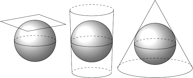
to an intermediate shape. The two most common intermediate shapes are a cylinder
and a cone. Both the cylinder and the cone may be transformed into a plane with
no distortion. While not all projections are formed in this manner, many of the most
commonly used projections are either cylindrical, conic, or planar, as shown in Fig-
ure 10.5. Distortion is always minimal at the location where the shape touches the
globe, such as the equator for many cylindrical projections [6].
(a) Planar (b) Cylindrical (c) Conical
Fig. 10.5 Projections are created by projecting Earth’s surface onto a surface that may be trans-
formed into a plane.
10.2.1 Different Map Projections
Theoretically, there are an infinite number of different map projections. In practice,
there are merely dozens in common usage on paper maps. For the purpose of tile-
based mapping, there are only a few map projections which are important to discuss.
Tile-based mapping systems, or any computer mapping system, must focus heavily
on interoperability. Thus, the projections used in these systems tend to be limited to
10.2 Map Projections 171
a few standard projections. In contrast, paper maps do not need to interoperate with
any other data or system and may select the projection with the best utility for the
map’s specific view of the Earth.
10.2.2 Cylindrical Equidistant Projection
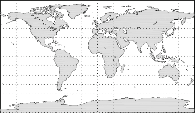
The first important projection for tile-based mapping is the cylindrical equidis-
tant projection. This projection is sometimes called the Cylindrical Equirectangular,
Plate Carr´ee, Simple Cylindrical, WGS84 Geodetic, or WGS84 Lat/Lon projection
[7]. The cylindrical equidistant projection does not scale the meridians of the orig-
inal globe. Thus, distances are not distorted north-to-south. However, each line of
latitude is stretched to the same length as the equator, providing significant stretch-
ing east-to-west. The distortion in this projection ranges from 0 at the equator to
infinity at the poles. Additionally, neither area, shape, nor bearing is preserved on
the map. Figure 10.6 is an example of a geodetic map of the world.
180
°
W 150
°
W 120
°
W 90
°
W 60
°
W 30
°
W 0
°
30
°
E 60
°
E 90
°
E 120
°
E 150
°
E 180
°
90
°
S
75
°
S
60
°
S
45
°
S
30
°
S
15
°
S
0
°
15
°
N
30
°
N
45
°
N
60
°
N
75
°
N
90
°
N
Fig. 10.6 Geodetic projected map of the world.
The benefit of this map projection is the ease of construction, especially for com-
puter mapping systems. One degree of latitude and one degree of longitude are the
same length in any area of the map. The same is not true of other projections (see
Mercator projection below). As a result, the resulting map forms a simple Cartesian
coordinate system of the world, centered at longitude and latitude (0,0). Another
useful consequence is that each pixel in a map image represents the same distance
172 10 Map Projections
in both the east-west and north-south directions, simplifying calculations performed
on map images.
10.2.3 Cylindrical Equal-Area Projection
The cylindrical equidistant projection is simple and easy to use; however, it offers
little beneficial map properties other than simplicity. The parallels are stretched by
a value of sec
λ
,where
λ
is the latitude. By scaling the projection by a factor of
cos
λ
, we can create the cylindrical equal-area projection. The cylindrical equal-
area projection preserves the area of features but not the distances between them or
angles on the map.
The cylindrical equal-area projection is a rarely used projection, in both printed
maps and computer map images. However, it is useful when used with data in the
cylindrical equidistant projection. Maps at large scale can be reprojected to equal-
area by multiplying by the cosine of the average latitude of the map. Reprojecting
to equal-area projection at display time can reduce visible distortions of features.
10.2.4 Mercator
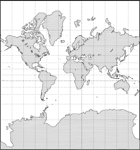
The Mercator projection is a cylindrical conformal projection where the cylinder
touches the globe at the equator. A conformal projection preserves the angles and
shapes of features on the map. This property makes conformal projections popular
in traditional mapping and cartography. Historically, conformal maps were useful
for navigation because straight lines on the map have constant bearing. Ships would
not have to change bearing in order to follow a straight route on a conformal map.
Land surveyors find a conformal projection useful because angles measured on the
ground can be transfered directly to the map for use in computation.
The Mercator projection is one of the oldest known map projections, dating from
the 16
th
century [7]. Similar to the previous two cylindrical map projections, the
Mercator projection has equally spaced and equal length lines of longitude. Lines of
latitude are also of equal length but are not equally spaced. Distance between lines
of latitude increases away from the equator. The result is a distinct increase in size
of features towards the poles. The features themselves are the same shape as on the
globe. Figure 10.7 is an example of a Mercator map of the world.
10.2.5 Universal Transverse Mercator
The Transverse Mercator projection is a cylindrical projection similar to the stan-
dard Mercator projection. However, rather than deriving the projection from a cylin-
10.2 Map Projections 173
180
°
W 150
°
W 120
°
W 90
°
W 60
°
W 30
°
W 0
°
30
°
E 60
°
E 90
°
E 120
°
E 150
°
E 180
°
E
75
°
S
60
°
S
45
°
S
30
°
S
15
°
S
0
°
15
°
N
30
°
N
45
°
N
60
°
N
75
°
N
Fig. 10.7 Mercator projected map of the world.
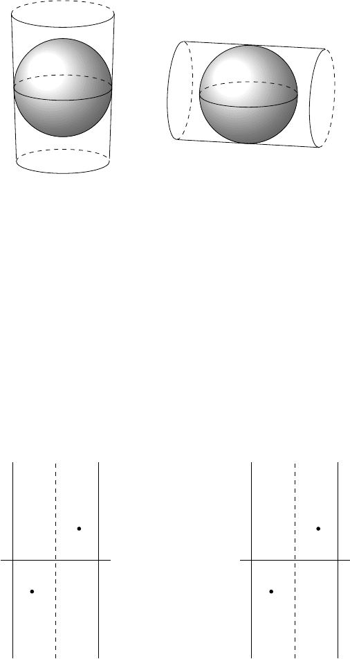
der oriented vertically pole to pole, the Transverse Mercator projection is based on
a cylinder oriented horizontally parallel to the equator, as shown in Figure 10.8.
Lines of latitude and longitude are no longer straight in the Transverse Mercator
projection. Whereas the Mercator projection distorts features farther north or south,
the Transverse Mercator projection distorts features lying farther east or west from
the central meridian. The projection can be made using any line of longitude as the
central meridian and provides little distortion to areas within a short range. As a re-
sult, the Transverse Mercator projection is often used for maps of small scale for use
in land surveying. Transverse Mercator maps primarily use rectangular coordinates
(meters) to simplify ground calculations over small areas.
Universal Transverse Mercator (UTM) is a standard coordinate and projection
system commonly used for imagery, topographic maps, and other low scale geospa-
tial data. The UTM system covers the entire world from 80
◦
Sto84
◦
N. Each hemi-
sphere is split into 60 zones 6
◦
wide. Zones are number 1 to 60 from west to east
starting at 180
◦
W. Zones are identified by their zone number and hemisphere (North
or South).
Each UTM zone has its own specific projection and coordinate system. The cen-
tral longitude of each zone is used as the central meridian for a Transverse Mercator
projection. UTM uses a rectangular coordinate system with the origin at the inter-
section of the central meridian and the equator. Locations are identified by their
174 10 Map Projections
(a) Mercator (b) Transverse Mercator
Fig. 10.8 Mercator and Transverse Mercator both project the Earth’s surface onto a cylinder. The
difference between the two is the orientation of the cylinder.
easting and northing values , the distance east and north in meters from the zone
origin. However, in order to prevent negative easting and northing values a constant
is added to all easting and northing values. This constant is called a false easting or
false northing. UTM specifies a false easting of 500,000m in both hemispheres and
a false northing of 0m in the Northern Hemisphere and 10,000,000m in the Southern
Hemisphere. For example, in Zone 1 South, the intersection of the central meridian
(174
◦
W) and the equator is given the coordinate 500000E, 10000000N. Figure 10.9
shows the coordinates of two points before and after the conversion to false northing
and easting.
0
◦
N
(50,000m, 100,000m)
(-50,000m, -100,000m)
Zone 2N
Zone 2S
174
◦
W 171
◦
W 168
◦
W
(a) No False Easting/Northing
0
◦
N
(550,000m, 100,000m)
(450,000m, 9,900,000m)
Zone 2N
Zone 2S
174
◦
W 171
◦
W 168
◦
W
(b) With False Easting/Northing
Fig. 10.9 False northing and easting values are simply an artificial translation of the coordinates
to ensure they are non-negative.

10.3 Point Reprojection 175
Since UTM zones are only 6
◦
wide, the amount of spatial distortion on any UTM
map is small. As a result, UTM is used frequently in satellite and aerial imagery.
Source data used in tiled map systems will often be projected using UTM. For ex-
ample, USGS produced Digital Orthophoto Quadrangle (DOQQ) aerial imagery is
distributed using UTM.
10.3 Point Reprojection
Often, it is necessary to convert between projections in the process of creating a
tiled-mapping system. Source data will often be distributed using a projection such
as UTM while data in the tiled-mapping system will be stored natively in a global
projection such as Lat/Lon or Mercator. We will present some basic reprojection
formulae and techniques and demonstrate the process of converting from UTM to
Lat/Lon.
Before covering techniques for reprojecting images, we must explain how to re-
project individual points. We will present the forumlas here along with some exam-
ple code. The formulae and a more thorough explanation can be found in Snyder’s
”Map Projections: A Working Manual” [7].
Below are the formulae for converting a Geodetic coordinate into a UTM coor-
dinate:
x = X
0
+ k
0
N
A +(1−T +C)
A
3
6
+
5−18T + T
2
+ 72C −58e
2
A
5
120
(10.1)
y = Y
0
+ k
0
M −+N tan
φ
A
2
2
+
5−T + 9C + 4C
2
A
4
24
+
61−58T + T
2
+ 600C −330e
2
A
6
720
(10.2)
where
e =
1−
b
2
a
2
(10.3)
e
2
=
e
2
(1 −e
2
)
(10.4)
N =
a
1−e
2
sin
2
φ
(10.5)
T = tan
2
φ
(10.6)
C = e
2
cos
2
φ
(10.7)
A =(
λ
−
λ
0
)cos
φ
(10.8)
M = a[(1 −e
2
/4−3e
4
/64−5e
6
/256−...)
φ
−(3e
2
/8+3e
4
/32+45e
6
/1024+...)sin
2
φ
+(15e
4
/256+45e
6
/1024+...)sin
4
φ
−(35e
6
/3072+...) sin
6
φ
+ ...]
(10.9)
and
