Indian National Committee on Large Dams. Design and Construction Features of Selected Dams in India
Подождите немного. Документ загружается.

end
of a
similar
pressure
diagram
will
run
to
zeto at the
downstream
face.
The
pressure
is
assumed
to
act
ovet
100
per-
cent of the
area.
(3)
Extreme
Loading
Condition: The extreme
loading
condition
specified
that
the
reservoir
water
surface
-would
be
raised
to
maximum
flood level:
drains
be
considered
ineffective
and
earthquake
effects
excluded.
The
uplift
pressure
was
assumed to
vary
linearly
from
full
pressure
at
the
upstream
face
to tail-water
pressure
or
zeio
-as
the
case
might
be
at
the
down-
stream
face,
the
pressure
acting
over
100
percent
of
the area,
If
the
up-lift
pressure
exceeded
the
vertical
normal
stresses at
the
upstream
face
(computed
without
uplift
-
but
including
.th9
effect
of the
c6nstruction
progamme)
then
under
such
conditions
a- horizontal
crack
should
be
assumed
to
exist.
This
crack
should
be
assumed
to
extend
from
the
upstream
face
into
the
interior
of
the
dam
to the
poiqt
where the
vertical
normal
stress
in
ine
cantilever
was equal
to
the
reservoir
pressure
at
that
elevation.
Ing.
uplift
for
ihis
condition
was
taken
as
full
reservoir
pressure
extending
from
the
upstream
face
io
the
end
of
the crack
and from
there
varying
linearly
to
tail-water
pressure or
.zerio,
is
the
case
might
be,
at the
down-
stream
face
of
the dam.
(xff)
All
transverse
and
longitudinal contraction
joints,
whether
to be
grouted
or left
ungrouted,
assumed
to be
keyed.,
(xiii)
If results
determined
from trial load twist
studies showed that the
transverse
contraction
joints
in
the
dam'
should
be
grouted
it
was
to be
assumed
that
the
recommendation
would
be
carried
out
and that the
joints
would
be
thoroughly
grouted
with
the reservoir
level
at
the
elevation
determined
from the analysis.
(xiv)
The
inclined stress
parallel
to
the face
of a
cantilever
was
equal
to
the vertical stress
divided
by
the square
of the
cosine of the
angle between the
face and the
vertical direc-
tion minus the
water
pressure
normal to the
face multiplied by
the squ:rre of the
tangent
of
the angle
between the
face and
the
vertical
direction.
(xv)
The
dam
was
considered to be
non-symmetrical
and
non-symmetrically loaded.
(xvi)
The idealized
profile
of
the
dam
on
the
beam
centre
lines
was
used in
the
analysis.
(xvii) Due to the broken
condition
of
the
rock
above
EI.498.3
m
(1,635
ft) MSL
at
the
right abut-
ment
(looking
upstream), it
was
assumed
that
no
load
would
be
transferred horizontally
to
the
right
abutment
above this elevation.
(xviii)
For
the
purpose
of these
analyses all
references
-
made to the
left
and
right
side
of the
dam
were
for
the
profile
of the canyon
looking
upstream.
(vfi)
Uplift
pressure
assumed
earthquake.
to be
unaffected
bY
(viii)
Stresses
assumed
to
be
unaffected
by
pressure.
they
would
be excavated,
treated,
and-
filled
with concrete
so
that
uniformly
sound
foun-
dation
conditions
would
exist
under
the
dam.
(x)
The concrete
in the
dam
would
be
homogeneous'
:
uniformly
elastic
in
all
directions,
3ld
strong
enough
to car5y
the
applied
loads
with
stresses
well below
the
elastic
limit.
(xf) The
dam
would
be
thoroughly
keyed
into'
the
foundation
and abutment
rock
throughout
its
contact
with the canyon
profile,
so that
the
horizontal
elements
might be
considered
as
fixed
with
relation
to the
abutments
and the
cantilevers
as
fixed
rvith respect
to
the
foundation.
The
relevant
summary
and conclusions
of
1952
uplift
study
are as
follows
:
(a) The results
of study 2A
have
shown
that :
(l)
For
normal
operating
conditions,
earthquake
'
forces
excluded,
the
section
of the
dam
has
shear
friction
factors
on
horizontal
and
abutment
planes
greater
than
4.
(2)
For
normal
operating
conditions,
earthquake
forces
excluded,
the
maximum
compressive
stresses
created
in the
dam
are
less
than 43.9
kg/cm'
(625 p.s.i.).
(3)
For
normal
operating
conditions,
earthquake
forces
excluded,
no
beam
stresses
are
deve-
loped
even
when
the
transverse
joints
are
grbuted, because
beam
action
is
developed
6nty
during
an earthquake.
The
tensile
p.rin-
cipil
stress
developed
is
2-7
kg/cm2
(39 p.s.i.).
(a) Fof
normal
operating
conditions,.earthquake
forces
excluded,
the
upstream
cantilever
stress
including
construction
programme bears
a
minimum
ratio
of
70.4
percent
to
the
corres-
ponding
hydrostatic
pressure. If full
uplift
20
pressure is
developed,
and the
cantilever
is
assumed to crack, then
the
resulting minimum
shear
friction
factor over
the
uncracked
length
of
a horizontalsection
is
greater
than 1.5.
Judged
on the basis of design
criteria adopted for
dams
designed
by
and constructed
under the su1rcr-
vision
and
control of United
States Bureau
of
Recla-
mation,
the results
of
study
2A
indicated
rhat
under
normal
operating
conditions
earthquake forces being
excluded, the
section
of
the
dam is
satisfactory
whether
the
transverse
joints
are
grouted
or
not.
(b)
A
comparison
of the
analysis
which includes
earthquake
forces,
study
2-transverse
joints
ungrouted
and
study
zB-transverse
joints
grouted,
showed
that :
(l)
For study
2
the shear
friction factors are
greater
than 4
irrespective
of the
assumptions
for uplift'pressures
and
coefficient
of friction.
(2)
For study 2B
the
minimum
shear friction
factor
on
abutment
planes
is
3.75 when
two-
thirds
area uplift
and
coefficient of friction
0.65
are
assumed;
and is
3.99
when
the
new
uplift
criterion
and
coefficient of internal
friction
0.80 are
assumed.
(3)
The maximum
compressive
stresses are
less
than 43.9
kg/cmz
(625
p.s.i.)
for both
studies.
(a)
The
minimum
ratio
of upstreanr
cantilever
stress, including
construction
programme,
to
the
hydrostatic pressure
is 3.5
percent
for
study
2,
and 36.7
percent
for
study
28.
Subjec-
ted
to
the
extreme
loading
condition,
drains
being inoperative
and
the
cantilever
assumed
to crack,
the
resulting
shear
friction factors
are
greater
than 1.5.
(5)
No
beam
tension
is
created
in
the
conditions
represented
by
study
2. The
maximum beam
tension tbr
study 2B
is
6.61
kg/cmz
(94 p.s.i.).
(6)
The
maximum
tensile
principal
stress is7.73
kg/cm2
(l
l0
p.s.i.)
for
study 2 and
11.46
kg/cmz
(163
p.s.i.)
for study
28.
On
the basis
of
this
comparison
of
results it was
considered
advantageous
to
leave the
transverse
joints
ungrouted.
However, there were
some
factors that
werc
not
brought
out by a study
of the
results,
and
these relate
primarily
to
the fact that
a
dam with un-
grouted
transverse
joints
is
not
a
monolithic
structure.
For
a
dam
of less
height
than Bhakra.Dam this might
not
have
been
an
important
consideration.
There was
no precedent
of
a
dam
of
the
size of Bhakra having
been
constructed
with
ungrouted
transverse
joints.
The
proposal
of
not
grouting
the transverse
joints
in
a
dam
of the
size
and
configuration
of
Bhakra
was
considered
unsuitable.
This objection
was
raised from two
consi-
derations
;
first,
that in
ungrouted
dam the
transfer
of
load
to
the abutment
is
effected
through
the keyways.
surface
at
El.
512.1
m
(1,680
ft)
MSL.
_
(c)_
It was
proposed
that
the
transverse
joints
should
be
grouted
with
the reservoir
water
surface
held
at
El.
512.1
m
(1,680
f0
MSL.
The
effecr was
to
reduce
the maximum
beam
stress
in
comparison
to the
condition
of reservoir
El.
466.3 m
(1,530-f0
IUSI-.
However,
from
practical
consideratiohs
the trans-
verse
joints
were
grouted
when
the average
reservoir
was
at El.
499.9
(1,640
ft)
MSL
but above
El.
403.8 m
(1,620
ft)
MSL.
Subsequently,
the
adequacy
of
structure was
tested
for
maximum
reservoir
El. 515.1
m
(1,690
ft) MSL.
In
view
of
the
maximum
reservoir
level being
effective
only
for
short
duration,
the increased
stresses were
considered
to be
within
safe limits
for the section
already
provided.'
In
addition
to
these studies, photo-elastic
studies
and biharmonic
analysis
of the
dam section
for
delinea-
tion
of upstream
strut
and
plug (provided
for upstream
claystone
band
and
not
considered
part
of
section for
trial load
studies)
were
also made.
Another
set
of
trial load
twist studies
for
actual
valley
profils
and
construction
schedule
were
made
for
study
of
prototype
behaviour.
2.5
Foundation
Treatment
of the
Dam
Treatment
of Ctay
Bands:
The
three
clay-banrJs,
i.e.,
the heel
clay
stone
band,
the
middle
clay stone band
and
the
downstream
clay
stone
band
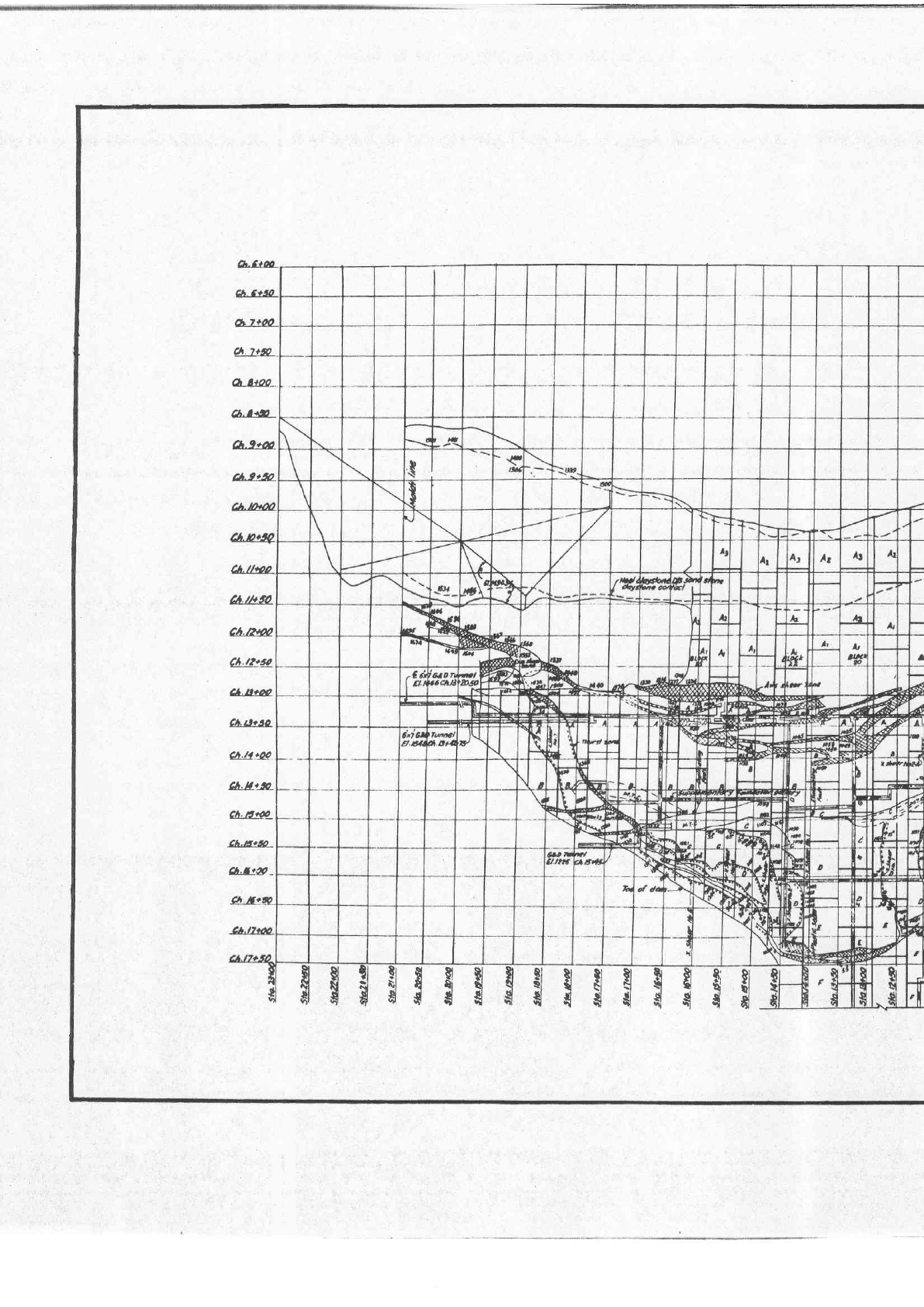
traverse the foun-
dation area
as shown
in
[Figures
7
(a)
& 8].
These clay
bands
though capable
of carrying
great
loads in
a
confined and unweathered
stage
become
plastic
when
submerged
and disintegrate
under conditions of alter-
nate drying
and
wetting.
As such
suitable
steps
were
taken to treat
these bands
as described
hereafter.
2l
,;"^lIeellClay,Stone
:
The
heel-clay
stone
is
30
tb
45
m
(I00.to
'150_ft)
wide
and
dips
at an
angle
of
70"
down_
stream-.
with -
the
nearest_point
22.5
m
(zs
ft) upstream
of
thb
heel
of
the
dam.
Ii
recedes
away
fro'rnthe
dam
at
higher-elevation's.
It
was
considered
ihat
on
accounr
of
continued
submergence
under great
d-pths
of
water,,
this
band
pig-ht
become plistic
and
livJwat
under
the load
of
the
dam.
It
wai,
therefoie,-decidei
to
bxca'vate
the
clay
band
in
the
river
r""iion
to
a
suitable
depth
and
backfill with
concrete.
Further-
more'
a'concrete
sffut
of
adequate
thickness,
spannin!
Jh!.
clay-band,r,
lvas -prop
osed-for
transferring
tde
roadi
to
the upstieam'sandstone,.called
footwall.
-
Photoelastic
studies
were
carried
out
to determine
the stresses
expected
to
exist
in
the
vicinity
of
the
clay
'stonii/silf
stonel
under
various
conditioniof
load
and
with various
depths
of
,proposed
treatment.
These
tests indicated
that
stresses'iin
the
bed rock
adjacent
Jo
the
ploposed
treatment
in the
clay
stone/silt-stone
stratum
decreased
rather
rapidly
for
depthi
down
to
30
rn
(100
ft)
andvarygradualiy
thereafter.
Itwas
'apparent
that
the depth
of
plug
beyond
30
m
(100
ft)
did not
materially
bontribute
to
-reduction
in
i
the
stresses
at the
base
of rhe
plug.
A
22.5 m
(75
ft)
plug
red,ug-qd
'stresses
to
"within
p-ermissibf"
fiiits
uod
*ur,
therefgre,adopted.',
-,
:
!
rj
Photoelastic
experiments
further
indicated
that if
the
bottom
of
the
plug
was
sloped
parallel
to the
strut,
tensile
stresses
in
it were
eliminated.
This
fact
caused
4e
gpgtqeam
end
of
footwall
contact
to be
depressed
to
El.
292,6
m
(960
fr).
_
T*o
longitudinal
galleries
(which
were
connected
1q
thg-dam
!y 1oeans
of three
transverse
galleries)
were
provided
within
the
plug
following
the
upstream
and
downstream
clay
sandstone
junctiois
for
^grouting
the
contacts.
and
consolidating
disturbed
sandstone
beds
to.?
denth of
about
-15.2
m-(50
ft),
This
grouring
was
a laborious
task and
completed
in
1960.
Water
tisting
in
these
zones
in
1963-and 1964
showed
good
water
tightness.
For
side
slopes
above
the rivEr
bed
an
adequate
toncrete
ccver
was
provided
to,confine,:the
clay
stone
members.
i,
"
,_.
!t[id{e Qtoy
Stone:
'
The
midOle
clay stone
band
varies
in
width_
from
6 m
(20
ft) to
I m
(30
ft)
and is
comp.letely
confined
by
the
dam
except
where
it
passes
out
from
under
the
dam
in
the
left
abutment.
.It.;is
treated
by
excavating
the
same
and
backfilling
with
sp^ecially
-p_re_c^o_oled
cbncrete
with
placing
temperature
of
10o
to
l2.8oC
(50:
to
s5"r;.
The
treichin!
depth
was
based
on
formula
derermined
by the
Unitet
stites
Bureau
of
Reclamation
for
Shasta
Da*
:
.,
d=0.002
H'W
*,,I0
ft.
Where
,
d
is
the
normal
depth
of
trench
in
feet.
H
is
the
height
of
the dam
above
sound
rock
infeet.
r;
:---:-.
,
.
W
is
the
width
of"the
zong
in
feet.
22
The
sandstone
contact
special
feature
for
the
r
supplementary
longitudin
runs
;ust
upstream
of
th
provided
with
a
view
to
yhic-h
might
pile
up
agains
.Dand.
"
Downstream
-clay
pand:
This
band
iJbes
not
affect
the
stability
otthe
dam.in
any
*uv.--rr"*".*r,
the rert
Foygr
pl?nt
is
founded
on'it
uii.,
urrvioiir;
suirable
raft
foundation.
.,.
'S'hear
Zones
s
mostly
in
the
body
of
the
I
the
axis
from
station
3.7
m
17
ft).
On
right.
abutment
nerge
into
the
thrust zone
at
i
m
(1,550
ft). In width
the
rm
3,m
to
6
m
(10
to
20
ft).
this
zone
to
prevent
further
rock
in
proximity
or
under
The
treatment
consisted'of
:
(t)
Cold
concrete
c?p
to
formula
depth,
i.e.,
l!
to
2
tlmes
^the
width,
subject
i.?_i"i_um
of
l
m
(r0.ft)
lp
to
erevatioii
oi
jis.il^tizoo
rt)
(top
of
dam).
(ii)
consolidation
grouting
of
afljoining
rock
on
both
sides
of
ihe
"on".,
uoa
p".ooiri6n-of
ade-
quate
sub-surface
drains
whire
;ti,
thin
to
prevent
uplift
pressure
as
a
consequence
of
rapid
drawdown.
Toe
Shear
Z9n9:
This
zone
runs
along
the
toe
of
the,dam
on
the
reft
abutment
and
varies
l" *ioin
from
6 tg
]8
m(20
to_
60fr).
The
trearmentof
this
bed
TocF
feature
in
_the,
area
where
substantial
toe
thrust
i.:,.1-ry:.^1^ty
the
toade{
Oam
consisted
of
piugging
wltn
concrete
as
per
standard
formulae,
,uppGmenteO
by
a
fillet.!9
r99k
on
the
downstream
side
of
the zone
wnere
practrcable.
it
zone
consisting
of
gouge
arying
from
0.6
to 4.3
m
(2
butment
obliquely
from
El.
rwnstream
side'to E,l.
457.2
area,
this
thrus
t
zone
joins
t,li?,i1T;.,:'rll:r"rH:";i
alogt
Et..472.4
m
(r,550
ft).
c;
rh;
;;;;;;;.;m
side
or rhe
abutment
area
but
rvithin
the
section
of dam,
the thrust
zone
joins
into
a
claJ;
stone
band.
The
strike
of
the
thrust
zole
in
question
is
nearry
at
right
angles
to
the
gorge-
fne,,Aiir
along
ihe
rigti
QL-LI&-
CLttoo,.
4.tq!l)
Ch.9ean
4.9tta
tA.rhro
cA.tw
h!2.50.
aL.Em?
Ch.r3+3O
Q.llt-@
Ch.nt&_
ct
Eg_
Ch.tsolro*
Ch.rtfil
_
$$lil
$
sfl
$l$!l!1
fl{$$l
nfiEi
.t
qd
L)/
:4_-_
__l
I
h.AleA
ch.
tttp
-Jct4r*
J7!Q
$
$$
R $
flfifis$
I
PLr
MAIN GEO
IN
FOUNDATI(
r
23
.
BHAKRA
DAM
PLAN
SHOWING
MAIN
GEOLOGICAL
FEATURES
l]'f
FoUitDATtoN
a AEUTTENTg
OF
grag
I
t
a
$
I
t
s
I
+
|o
t
Y)
Et
t7O0
fl 6e0t
?xl
-1
I
F
\
\
i
250
, t-1_.|"--|_}-l
drilled
downtords
fftrtTTTfi-iT]
t.
,--Pro'
lz-Fffitz.4ptlofhola,.tobe
ffi
-.-J'
pres,
-
l-Lfffi
-
anlcd upwrds
ft'1] |1Tf l I I i]
{r
zont
ll
litrilt'++t'++ffi1 i+i1+fiifll
----
ptt*,
ul
qatting
9".d
d'd:
SO
Tii,g,;"-i
tz'lc'
from
th
5i
'-
f-l
iffift1j1+lf#{+i,h,s
smph
h",*,t?:,t
ry:
2OO 25A
bol
inlo cone,,ctC
)
--Olac!-*
-rr
1RAPtj
FoR
'G'uott
LENGTHS
(to
u
dri//ed
lrom Harn
Foudohort 6al9ry
od
'olleryotd
6t
D
ftnrcls)
upword
'6'hoEs
blwcen
iourtoh'on
gailcra and
ft
I
I
I
I
I
I
I
I
I
I
I
tl
rl
il
tl
!i
tl
I
I
I
I
I
I
I
I
I
I
I
I
I
I
I
I
I
I
I
I
I
I
I
I
I
1
I
I
I
I

finol
acortliu,
ltE
AtLOcl<
30
ghplum
--6toulng
qd
druooi,
lfiTl'
'"F'
Ho'lal
t
l'
mn
dioqP1
b'notcs
ti-,
Lttt-
n
DL
0cl4
25
,
Y.
itu
I
I
I
I
SECTION
A-A
o
o
t
N
o
a
o
o
I
s
/
--1---/
-
-- _L--+--
//
ll
Yet6,6!
'6'lo/es
ar,/,
b"
nci;ncd
'wrlh
lhc'
tvnYord
f'holabcltcan
illerl ond
lurnel
Y%,_____
lNOATION
6I LLENY
dja O5't
cln
AXts oF
0A
(s::'r^--filiiiiii
i\iixy,n#ii::,',)
rili
i
;
I''donoe
htrnct
i |
|
(iiiii
itr
rrat.ct
r,o
ni,r,
6A

\
'6'
Ho/os
6
5't
ctn
ll"
6'rl'
nrouli rrg ort
i!.1,1,
/e*top
lutncl
i ll
El.
ltfl|. 6
ltt
10.
t !
1j,4
itzrtthat
unlt
iiijiqiiiiii
o'e
El
plane
vilh
lhe,ailtcol
SCALE
O
/OO
FEET
BHAKRA
DAM
FOUNDATION
TREATMENT
CURTAIN
GROUT
ING
FIGURE
8
(bI
It
rl
It
tl
il
ll
ll
I
I
I
I
I
I
I
\
I
I
I
t
I
I
I
I
I
I
I
I
I
I
ii
;l
!l
rl
It
ll
It
lr
I
I
I
I
I
I
I
I
I
I
I
I
I
I
I
I
I
I
I
I
I
I
I
I
I
I
I
I
I
I
I
I
I
I
I
I
I
I
I
I
I
I
abutment
face varies
from
moderate
up to
about
50
degrees
in
a downstream direction,
with a
slight com-
ponent
of
dip
into
the cliff.
The
defective
thrust zone is important as
there
was
the
chance of sertlement
of overlying
rock
and
section
of
dam
above, due
to
consolidation
and
squeezing
under
combined load
of dam and
reservoif water.
Treatment
necessary
to
prevent
undesired settlement
either
as
a
result
of load,
or in combination with
effects
of
piping
through
seepage
was
as
follows :
(a)
Percolation
of reservoir water
along
the
thrust
zone was
stopped by
a
tunnel 30.5 m
(100
ft)
driven
in
line of the
principal grout
curtain
into
the
abutment,
backfilled with
concrete and
contacts grouted.
(D)
Prevention
of squeezing
out of disturbed
material
was
achieved
by
two
plug
tunnels,
one
15.2 m
(50
ft)
deep
along
the
zone
under the
heel
of
the dam
and
the
second tunnel of
12.2
m
(40
ft) depth
along
the
zone,
at
the toe
of
the
dam.
The contacts of
these concrete
plug
tunnels
were
pressure
grouted.
Inter-
mediate
concrete
plug
tunnels
were
also
put
in
to confine the
material.
(c)
In
order
to
prevent
settlement
where
the
over-
Iying wedge
of rock
in the abutment was thin,
a dental f,ll
of
concrete to a depth
of 6.1
m
(20
f0
minimum
was
formed
along
the full
trace of
the
thrust
zone in the abutment
area
of
the
dam
and
to the axis
shear
zone
upstream to ensure
that
there
was a
thickness
of
23 to 30.5
m
(75
to
100
f0
of
good
rock
immediately
above
the zone capable
of
carrying
the
weight
of
the
loaded dam.
Near
Horizontal
Cross Shear
Zones
Many
near horizontal
cross
shear
zones,
varying
in
width
from
a
few centimeters
to
about
a metre,
intersect
the
abutments
with strike
nearly
at
right
angles
to
the
gorge.
These
cut the sandstone
strata
and
consist
of
-
crushed material
with clayey material
infiltered
in
a closely criss-crossed
jointing
pattern.
The
fautt
planes
are
comparatively
flat and
irregularly
bedded
and
occasionally
shift
the
boundaries
of the
normal
beds.
These zones
needed
special
treatment
on
account
of
their
low
bearing
strength,
the tendency
of
the dam to slide
on shear
planes
and
percolation
of
water through
the seams
from
the
reservoir.
The
zones
were
exiavated
and
backfiiled
with
concrete.
Concrete
plugs
of
adequate
depth
were
provided at
suitable
places
as
described
below :
(i)
Plug tunnels
in
the
plane
of
the
cross
shear
zones at
the heel
of the dam extending
15.2
m
(50
ft)
into the abutment.
(tt)
A
plug
tunnel
30.5
m
(100
ft) in
length
in the
plane
of
the
cross
shear,zone
along
the line
of
main
grout
curtains.
(iii)
A
12.2
m
-(40
ft)
long
plug
tunnel
along
the
plane
of
the cross
shear
zones
at the
toe df
the
dam or
on
the
termination
of the
cross
shear
zone
out-crop
where
they
terminated
at
an
upstream
location.
(iv)
Dental
caps
to
a
depth of
about 1.5
m
(5
f0
were provided
along
the
outcrop of
the.cross
shear
zones.
The
bountlary
sandstone
along
the tunnel
plugs
and
dental
treatment was
grouted
under
pressure.
2.6
Consolidation
(Blanket)
Grouting
Besides the
special
treatment
of
weak
zones
men-
15.2
m
(50
ft)
below El.
426.7
m
(1,400
fr).
Consolidation
grouting
of
foundation
of
Bhakra
Dam
by
pressure
grouting
consumed
500,000 bags
of
portland
c€ment
(50
kg
each)
through 457,205.5
m
(1,500,000
ft)
depth
of
diamond drilled
holes.
The
intake
of
grout
at elevations
higher than
426.7 m
(1,400
ft) was
more
than
that
at
lower
elevations. Some
holes
'consumed
hundreds
of
bags even though
adjacent
holes had
previously
been
grouted
to
refusal
with nominal intake.
The holes
were
generally
aligned
so
as to
cut
maximum number
of
bedding
planes.
The
criterion
of
completion
was
to achievE water loss
of
less than
1.49
litre per
minute
per
metre
(0.1
gallon
per
minute
per
ft)
length of the hole
at the specified
grout
pressures
in a
diagonally drilled
test hole. The maxi-
mum
pressure
applied
did
not
exceed 7.03 kg/cmz
(100
lb
per
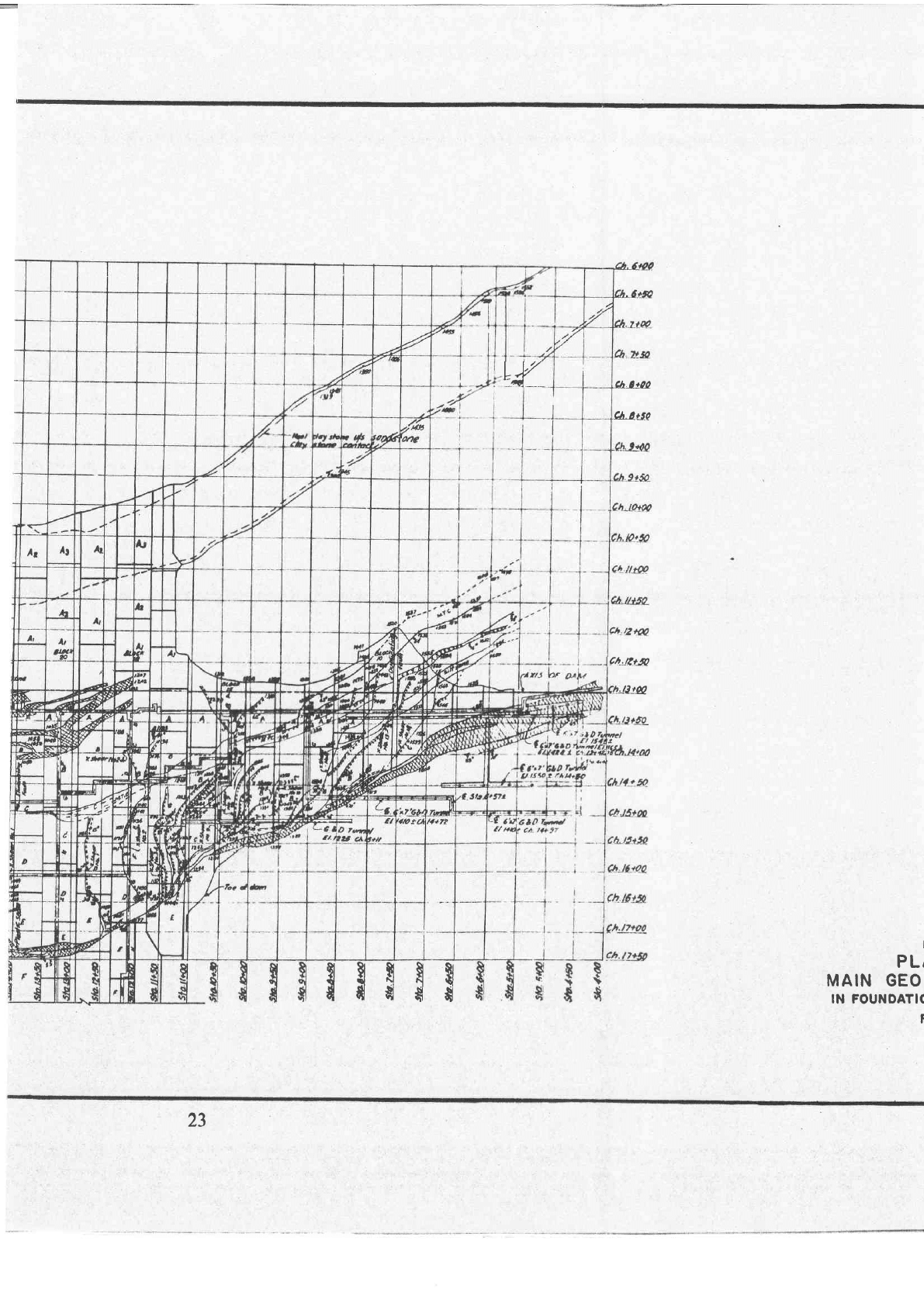
sq
in.)
[See
Figure
8
(a)].
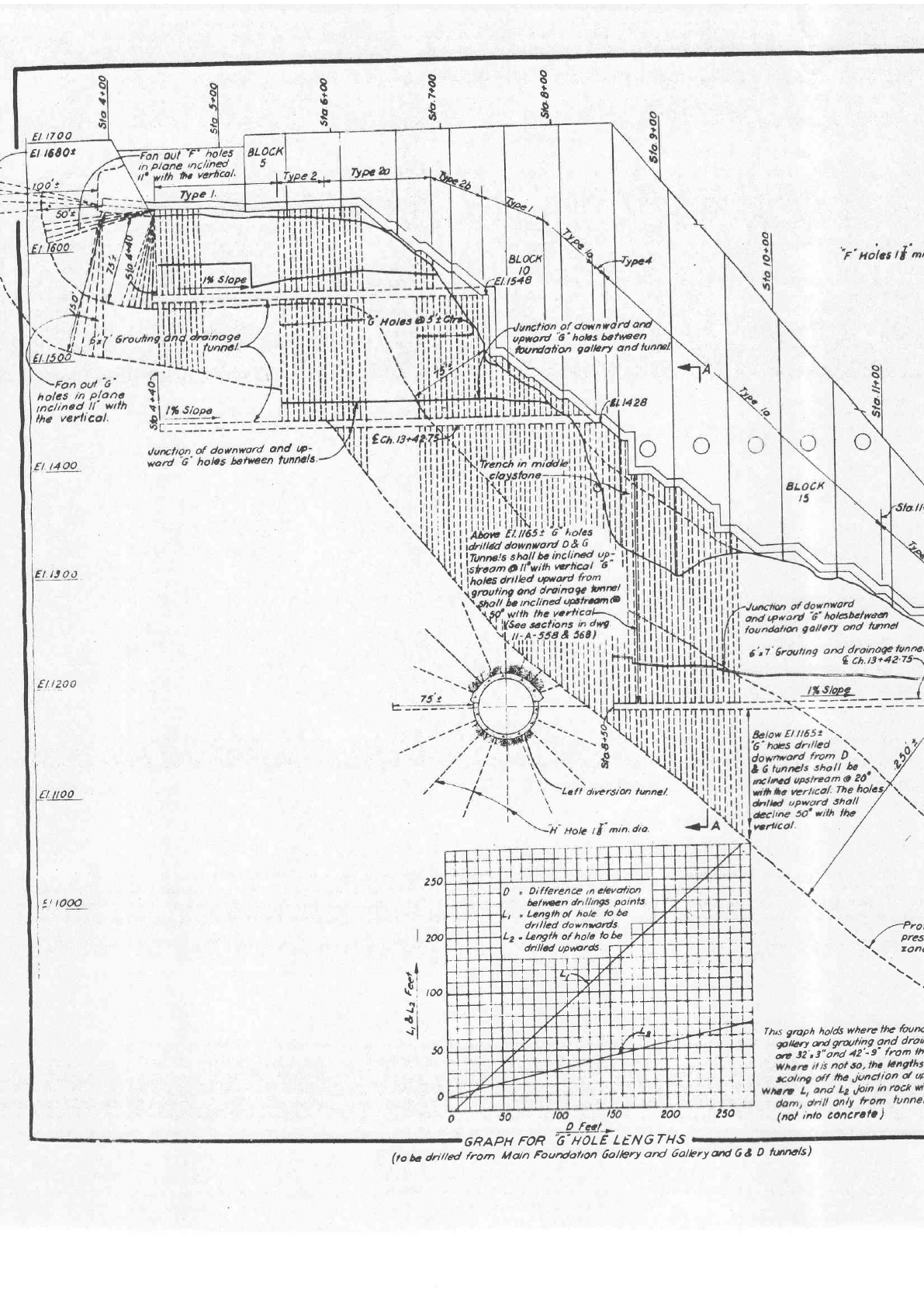
2.7
Intermediate Curtain Grouting
(F-Holes
Grouting)
The
depth
of
intermediate
grout
curtain
varies
from
23 m
(75
ft) at
the
abutments to 38 m
(125
ft) in
the
river
section
with
corresponding
pressures
varying
from
7.03
kgicm2
(100 p.s.i.)
to
17.6 kg/cmz
(250 p.s.i.). The
grouting
was
done
from
the
main
foundation
gallery
through
holes drilled
at 3 m
(10
ft)
centres
at
an angle
of
50o
with
the
veftical
towards
upstream.
The
work
was finished
upto
El. 487.7
m
(f,600
ft)
by
June
1962. Mean
grout
intake
in the
central
portion ranged
from 3
to
55 bags
of
50
kg
each
for
a
total
of
45.7
m
(150
ft) stage
depth
of
3
co'npa-
nion
holes
in
a
group.
The
maximum
intake
was
1,249
bags
ior
45.7
m
(150
ft)
stage depth
of
3
holes
taken
slmultaneously
in block 2
and
believed
to be
due to the
proximity
of
downstream
contact
of
sandstone
with
heel clay
stone.
Sornewhat
erratic
----4
"v
25
