Helena Ramos. Guidelines for design of small hydropower plants
Подождите немного. Документ загружается.

Hydrology
- 31 -
precipitation into runoff (rainfall-runoff process models). It should be noticed
that assuming relation (4.8) is equivalent to consider that the shapes of the
non-dimension chronological diagrams of the mean daily flow series
3
at the
stream-gauging station and at the scheme water intake are equal.
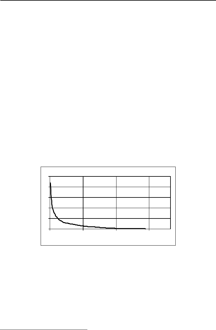
4.3.3- Mean annual flow duration curve
Two techniques are available to determine the energy potential of a hydropower
site, namely, the flow duration curve method and the sequential stream-flow
routing.
The evaluation of the mean annual energy production in a small hydropower
scheme with a run-of-river exploitation was traditionally based on a mean annual
daily flow duration curve. This curve gives for each value of the mean daily
flow, Q, the average number of days per year, D, during which occurred mean
daily flows equal or greater than Q (MOSLEY and McKERCHAR, 1992, p.
8.27) – Figure 4.6.
0
5
10
15
20
25
0 100 200 300
Time equalled or excedeed (day)
Mean daily flow (m
3
s
-1
)
Fig.4.6- Mean annual daily flow duration curve.
Once the mean daily flows at the hydropower scheme are evaluated, the
corresponding mean annual daily flow duration curve can be obtained by
organising those flows by magnitude instead of chronological.
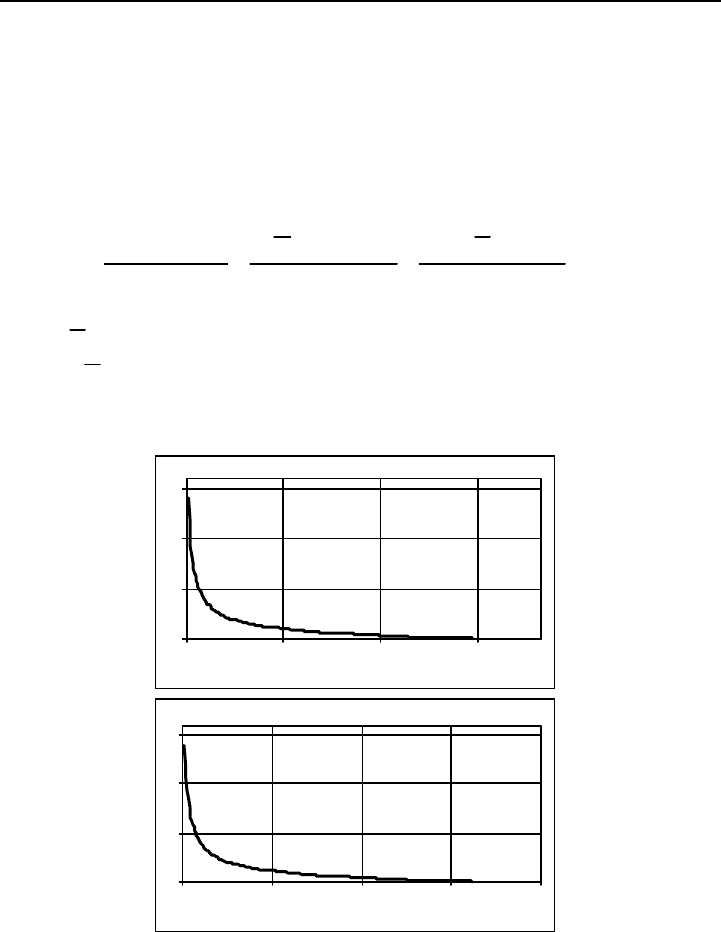
The flow duration curve can also be represented in a dimensionless form in what
concerns the mean daily flow series or both these flows and the time –
Figure 4.7.
3
Chronological diagram of the mean daily flows divided by the corresponding average.
Guidelines for design of SMALL HYDROPOWER PLANTS
- 32 -
In the previous figure Qmod represents the modulus or the average mean daily
flow derived from the known mean daily flows by summation and averaging.
For the hydropower scheme Qmod
HP
(m
3
s
-1
) can be obtained by one of the
following expressions:
6.324365.06.324365.0
AH
n365
q
modQ
HPHPHP
n
1i
365
1k
i
k
HP
HP
××
∀
=
××
×
=
×
∑
∑
=
= =
(4.9)
where
HP
H (mm) is evaluated by applying (4.3) or (4.4) or an equivalent
relation,
HP
∀ (hm
3
) is given by (4.7) and the meaning and units of the other
variables have already been presented.
0
5
10
15
0 100 200 300
Time equalled or exceeded (day)
Q/Qmod (-)
0
5
10
15
0 25 50 75 100
Time equalled or exceeded (%)
Q/Qmod (-)
Figure 4.7 – Dimensionless forms of the mean annual flow duration curve.
Taking into account the procedures that led to the mean daily flow series at the
hydropower scheme water intake,
i
k
HP
q (m
3
/s), it is easy to conclude that the

Hydrology
- 33 -
dimensionless forms of the mean annual daily flow duration curves thus reached
for the scheme and the one relative to the stream-gauging are equal.
Once a dimensionless mean annual daily flow duration curve is put in a
dimension form by multiplying its ordinates by a modulus, Qmod, the curve thus
obtained will become exclusively representative of the watershed to which that
modulus is referred.
The obtainment of a mean annual daily flow duration curve at an ungauged site
was traditionally based on the adoption of a standardised regional
nom-dimension duration curve. The curve selected was next synthesised by
multiplying its ordinates by the hydropower scheme modulus, Qmod, in order to
provide its particular flow duration curve with numerical discharges.
However, the previous traditional methodology only leads to reasonable results
with respect to the energy evaluation when no storage capacity is available in the
hydropower scheme, that is to say, when the scheme has a pure run-of-river
exploitation. At the same time and even for a run-of-river scheme, this
methodology only gives the estimate of the mean annual energy production and
it does not allow any simulation study in order to analyse the variability of the
energy production due to the natural variability of the flows.
Regional standardised flow duration curves are generally available in all
European countries. The criteria that lead to the establishment of those curves
depend, however, on each specific country. When selecting a standardised curve
care should be taken in order to ensure that the watershed of the hydropower
scheme and the one inherent to the regional curve are reasonable similar (in
terms of hydrological behaviour, climate, area, occupation and geological
constitution).
The procedures proposed in this chapter, namely those that result from relation
(4.8) are also regional transposition methodologies. The main advantages of
these procedures comparatively to the traditional ones based on the adoption of a
regional standardised mean annual flow duration curve can be systematised by:
• In what concerns the factors that determine the similarity of the flow
regime at the stream-gauging station and at hydropower scheme, the

Guidelines for design of SMALL HYDROPOWER PLANTS
- 34 -
methodologies presented herein allow a more rigorous selection of the
daily data to be transposed.
• They provide not only a mean annual flow duration curve but also a
mean daily flow series allowing the evaluation of the energy
production either in a pure run-of-river scheme or in a scheme having
some storage capacity, in this last case, by means of simulations
algorithms.
• In a general sense, whenever mean daily flows exist it is possible to
perform any simulation study. By this way, either the design of the
small hydropower scheme, or the comparison of different solutions for
the same become much easier.
4.4- Energy Evaluation
The evaluation of the mean annual production in a small hydropower scheme
with a pure run-of-river exploitation can be accomplished only by using the
mean annual flow duration curve at the scheme water intake. The simple
procedures that can be adopted in this situation are next briefly described.
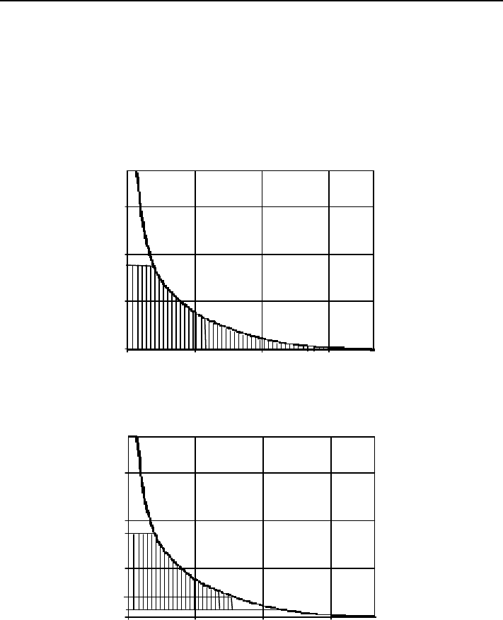
For this purpose, let Qmax denote the design discharge of the hydropower
scheme. In this situation, the maximum mean annual volume,
∀
, that can be
utilised in the energy production is represented by the dashed area of in Figure
4.8 a).
If the efficiency of the powerhouse, η, and the net head, ∆h (m), are considered
constants, the mean annual energy production, E (GWh), in the scheme having
the flow duration curve of Figure 4.8 a) is given by
η×
∆×∀
=
g
3600
h
E (4.10)
where g is the gravity acceleration (m s
-3
) and ∀ is expressed in hm
3
.
Most of the time, the average turbined volume will be less than ∀ as no turbine
can operate from zero flow to its rated discharge and, so, a minimum discharge,
Qmin, compatible with the energy production has to be considered.
Hydrology
- 35 -
A reserved discharge (for ecological purpose but also for others purposes as
irrigation or water supply) has also to be taken into account. In this situation the
mean annual turbined volume to be considered in the application of (4.10) will
be the one represented by the dashed area of Figure 4.8 b).
a)
0
2
4
6
0 100 200 300
Time equalled or exceeded (day)
Mean daily flow (m
3
s
-1
)
Qmax
b)
0
2
4
6
0 100 200 300
Time equalled or exceeded (day)
Mean daily flow (m
3
s
-1
)
Qmin
Qres
Qmax
Fig. 4.6 – Maximum turbined volume in a pure run-of-river scheme: a) without
considering and b) considering a minimum turbined flow, Qmin, and
a reserved flow, Qres.
Usually neither η nor ∆h will be constant but, instead, will exhibit a
non-negligible variation. In this situation, as well as when there is a storage

Guidelines for design of SMALL HYDROPOWER PLANTS
- 36 -
capacity, the mean annual flow duration curve does not provide a correct way of
estimate the energy production and other procedures have to be implemented.
These procedures generally simulate the exploitation of the powerhouse by
means of a sequential stream-flow routing methodology. The simulation studies
can be developed according to different points of view, namely:
• by adopting the mean daily flow series previously established for the
scheme, that is to say, assuming that the future flows will be equal to the
flows that occurred in the pass;
• by adopting a synthetic mean daily flow series obtained from the series
previously establish for the scheme water intake by a model, generally a
stochastic model (for instances, a disagregation model).
As this last option involves models far beyond the scope of this work, only the
first option will be considered.
The simulation studies have to be performed by means of a computational
program. The main data generally required for this program is the following one:
• mean daily flow series at the water intake of the scheme;
• design discharge, Qmax (m
3
/s), and minimum discharge, Qmin (m
3
/s),
compatible with the operation of the powerhouse;
• ecological discharge and any other discharge required for the
consumption between the sections of the weir and the outlet if the
powerhouse (reserved flow, Qres, in m
3
/s).
• head losses in the diversion circuit as a function of the diverted flow;
• rating curve at outlet section of the powerhouse;
• efficiency curve of the equipment of the powerhouse.
If the weir of the scheme creates a lagoon providing a storage capacity and if the
operation of the schemes foresees the use of this capacity in order to improved
the conditions of the energy production, the following additional data is also
required:
• the reservoir stage-capacity curve
4
;
4
A graph showing the relation between the surface elevation of the water in the reservoir, usually
plotted as ordinates, against the volume of water stored below that elevation, plotted as abscissa.

Hydrology
- 37 -
• the exploitation rules, that is to say, the rules that translate the way the
stored volume of water is going to be exploited, for instances, in order
to concentrate the energy production during the periods where the sale
tariffs are higher (or when the energy demands are higher).
The simulation algorithm is almost exclusively based on the application of the
continuity equation.
Let t
0
(usually t
0
= 0 s) denote the initial instant and t
i
(s) the instant i ∆t seconds
after t
0
, that is to say
t
i
=t
0
+i ∆t (4.11)
where ∆t is the computational time step (s).
In these conditions the volume utilised in the energy production during the time
step i,
i
∀∆ (hm
3
), will result from the “net” inflow also during the time step −
inflow to the water intake, I
i
(m
3
/s), minus the discharge over the spillway, O
i
(m
3
/s), minus the reserved flow, Qres
i
, (m
3
/s) − and from the variation of the
volume of water stored in the reservoir, ∆S
i
(hm
3
)
i
∀∆ = (I
i
-Q
i
-Qres
i
) ∆t + ∆S
i
(4.12)
The variation of volume ∆S
i
is a consequence of the exploitation rules which,
generally, results into the two following different actions:
• priority to the energy production;
• priority to the storage.
The former of the previous rules is generally applicable to the peak hour period
and the latter, to the low hour period.
When priority to the energy production prevails, the turbined flow should be as
great as possible. For this purpose, the inflow to the scheme water intake is
increased (if possible, until the limit of the design flow, Qmax), by emptying
totally or partially the reservoir.

Guidelines for design of SMALL HYDROPOWER PLANTS
- 38 -
If priority to the storage prevails, as much water as possible should be stored. In
this situation the powerhouse will work only if discharges over the spillway are
foreseen.
The computation of the energy produced during the time step i, ∆E
i
(GWh), is
accomplished by an expression equivalent to (4.10) but where ∀ is replaced by
the volume turbined during the time step,
i
∀∆ (hm
3
) and the variables ∆h and η
are replaced by ∆h
i
and η
i
in order to denote the specific conditions under which
the production occurred
i
ii
i
g
3600
h
E
η×
∆×∀∆
=∆
(4.13)
The estimate of the energy produced in the hydropower scheme, E (GWh),
during the interval between instants t
0
and t
n
, such as t
n
= t
0
+ n ∆t, is obtained by
totalling the production during the successive time steps
∑
∆=
=
n
1i
i
EE (4.14)
By omitting the term ∆S
i
of equation (4.12), the previous methodology is also
applicable to the evaluation of the energy production in a hydropower scheme
with no storage capacity. In this situation, the values of the remaining variables
that appear in (4.12) will only reflect the particular conditions − in what
concerns the net inflow, the net head and the efficiency of the equipment − under
which the production occurred during each time step.

Hydraulic Design of Small Power Plants
- 39 -
5
HYDRAULIC DESIGN OF
SMALL POWER PLANTS
5.1- Introduction
Civil works are quite significant in Small Hydropower Plants (SHP). The
investment is generally limited and there is not capability to spend so much on
geological or survey exploration, hydraulic and structural design. These
undertakings have the main advantage in the use of local materials and attracting
local people for the construction. They can not be scaled down from large
projects. A SHP design should be the result of the work of a multi-disciplinary
engineering or multi-specialist team including hydrologic, hydraulic, structures,
electric, mechanical, geologic and environmental experts.
Several types of SHP layout schemes are, essentially, characterised by different
intakes and diversion structures depending on the type of the conveyance
system. The powerhouse depends on the type of turbines. The headwork
typically includes a low dam or barrage belonging to low dam risk category (e.g.
depending on the specific legislation of each country).
Helena Ramos
A. Betâmio de Almeida

Guidelines for design of SMALL HYDROPOWER PLANTS
- 40 -
5.2- Layout schemes
5.2.1- Intakes
There are different types of intakes with diversion flow to the turbine through
the penstock: frontal, lateral, bottom drop and siphon type. For the two first
types it is necessary to design the entrance shape in order to avoid separated
zones of the flow and excessive head loss through wing walls. It is also
necessary for all types to verify the minimum submergence in order to avoid
vortex formation and, consequently, air entrance. The discharge control can be
improved by special structures (e.g. narrow sections, weirs and gates or valves)
depending upon if the flow is pressurised or of free surface type.
The elevation of the water level can be controlled by a weir or by an inflatable or
rubber dam or gate in order to create enough available head (H
o
) to divert the
desired discharge (Q
o
).
5.2.1.2- Minimum submergence
The vortex formation by insufficient intake submergence can induce air
dragging or even solid material to the intake, reducing the turbine efficiency.
The vortex development will depend on the geometry of the intake, the
submergence and the approach flow velocity.
Fig. 5.1 – Development vortex phenomenon (ASCE/EPRI, 1989).
The intake’ design criteria is based on the definition of minimum submergence
in order to enable the guarantee of non-vortex formation, with air dragging into
the hydraulic conveyance system. Several models and field studies were