Flechtner F.M., Gruber Th., G?ntner A., Mandea M., Rothacher M., Sch?ne T., Wickert J. (Eds.) System Earth via Geodetic-Geophysical Space Techniques
Подождите немного. Документ загружается.

The Release 04 CHAMP and GRACE EIGEN Gravity Field Models 43
actually improve the initial values for the gravity field parameters. Further details
are given in e.g. Reigber et al. (2005).
At the time of writing, the RL04 EIGEN-GRACE05S time series consists of
72 monthly gravity field models complete up to degree and order 120 cover-
ing the period between August 2002 and December 2008. The most important
changes in the applied processing methods, standards and background models com-
pared to RL02 EIGEN-GRACE03S are as follows (further details can be found in
the corresponding RL02, RL03 and RL04 GRACE Level-2 Processing Standards
Documents; Flechtner, 2005a, b, 2007a):
Arc Length: CHAMP and GRACE RL02 data were processed in batches of
36 h. As mentioned above, the optimum arc length within the dynamic approach is
always a compromise between “short” to avoid the accumulation of data and model-
ing errors during numerical integration and “long” to retain resonant longer-period
gravitational perturbations. Since the accelerometer data are treated as “true” non-
gravitational forces in the observation equations, the accelerometer errors and noise
are accumulated over time. Dedicated experiments for the intermediate RL03 time
series EIGEN-GRACE04S have shown that the processing of daily batches gives
slightly decreased observation residuals as well as slightly improved gravity fields.
GPS Data Processing: High-low GPS data are essential to observe the long-
wavelength part of the gravity field and to geo-locate the GRACE K-band measure-
ments. This is done in a two step approach: First the orbits and clock parameters of
the GPS satellites are adjusted from ground-based GPS tracking data. Then, in the
second step, the orbit determination and computation of observation equations of
the LEO (Low Earth Orbiter) is performed with fixed GPS spacecraft positions and
clocks derived from step one. The quality of this approach depends strongly on the
correct modeling of the GPS ambiguities or the phase center corrections. The ambi-
guity fixing of the GPS spacecraft constellation could be much improved within
RL03 by implementation of an integer ambiguity fixing algorithm to our EPOS
(Earth Parameter and Orbit System) software. The comparisons of our orbits with
those delivered by the IGS (International GNSS Service) for the period June 2002 to
December 2004 show a significant improvement (see Fig. 1), as the orbit differences
decrease from 4.1 to 2.6 cm (radial direction), from 6.8 to 5.0 cm (along-track direc-
tion) and from 7.0 to 4.2 cm (cross-track direction). The GPS ambiguities for the
LEO satellites are still estimated as floating point numbers because the integer ambi-
guity fixing algorithm has not yet been implemented within the LEO subroutines of
EPOS. This indicates further room for improvements. Azimuth/elevation-dependent
phase center patterns, e.g. provided by JPL for GRACE, have been implemented for
RL04 and led to slight improvements for the GPS residuals. As an example, for
August 2003 the GPS code residuals of more than 1 million observations decreased
from 36.3 to 35.7 cm and the phase residuals improved from 0.62 to 0.57 cm.
Static Background Gravity Field: The static background gravity field up to degree
and order 150 has been changed from EIGEN-CG01C (Reigber et al., 2006) to
EIGEN-CG03C (Förste et al., 2005) for RL03 and to EIGEN-GL04C for RL04.
EIGEN-GL04C is an update of EIGEN-CG03C based e.g. on the RL03 EIGEN-
GRACE04S satellite-only model (Förste et al., 2008a). In both cases the improved
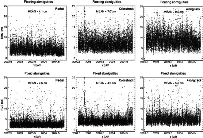
44 F. Flechtner et al.
Fig. 1 Radial (left), along-track (middle) and cross-track (right) orbit differences w.r.t. IGS orbits
in case of floating (top) and integer (bottom) fixed GPS ambiguities between June 2002 and
December 2004
static background model gave slightly decreased omission errors (“the impact of an
imperfect mean reference gravity model on the solution”).
Secular Rates: The secular rates for low degree harmonics have been completed.
While for RL02 and RL03 only the rates for C
20
,C
30
and C
40
with respect to the
reference epoch January 1, 1997 were a-priori reduced, the rates for C
21
and S
21
have been added and the reference epoch has been shifted to January 1, 2000. The
values of the C
20
,C
21
and S
21
rates are applied according to the IERS2003 conven-
tions (McCarthy and Petit, 2003); the C
30
and C
40
rates are taken f rom to Cheng
et al. (1997).
Ocean Tide Model: The FES2004 model (Lyard et al., 2006) is applied since
RL02. For RL04 the K
2
tide has been corrected to the FES2000 model values as
proposed in Lyard et al. (2006) and the non-linear tide M
4
has been added.
Non-tidal Mass Variations: Until RL02 the atmospheric and oceanic non-tidal
mass variations have been calculated with the barotropic ocean model PPHA
(developed by Pacanowski, Ponte, Hirose, and Ali; Hirose et al., 2001). But tests
performed in 2004 (Flechtner et al., 2006) indicated that this model has certain defi-
ciencies, e.g. the exclusion of the Arctic Ocean requires a pure inverse barometric
response assumption of the sea surface north of 65
◦
or a reduced energy when com-
pared to in-situ ocean bottom pressure. As a consequence, since RL03 the baroclinic
model OMCT (Ocean Model for Circulation and Tides, Thomas et al., 2001) with
global (including the Arctic ocean) output is used. For the latest RL04 atmosphere
and ocean de-aliasing level-1B product (AOD1B) OMCT is mass conserving, its
The Release 04 CHAMP and GRACE EIGEN Gravity Field Models 45
bathymetry is adjusted to the AOD1B land-ocean mask and it uses an updated ther-
modynamic sea ice model and a new data set for surface salinity relaxation. Further
details on the OMCT model and the de-aliasing product can be found in Dobslaw
and Thomas and Flechtner et al. (both in this issue).
Ocean Pole Tide Model: The model (Desai, 2002) describes the long-wavelength
component of the geocentric pole tide deformations at the Chandler wobble period
and is applied since RL03. A software bug in the implementation was corrected with
RL04.
Relativity: The general relativistic contributions to the satellite accelerations are
computed as specified in the IERS2003 conventions (McCarthy and Petit, 2003).
For RL04 the Lense-Thirring and de Sitter effects have been added as proposed by
IERS2003.
Reference Frame: For RL04 the IERS2003 nutation and precession model has
been implemented and the numerical integration of the orbits and variational equa-
tions is now performed in the Conventional Inertial System (CIS). Until RL03 it was
performed in the quasi-inertial True of Date System (TDS).
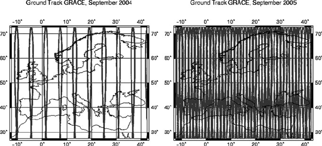
Statistical Constraints: GRACE experienced a 4d repeat cycle orbit between July
and October 2004. The resulting sparse ground track pattern (Fig. 2) caused instabil-
ities in the quality of the corresponding 4 monthly GRACE gravity field products.
To overcome this problem, also constrained solutions (using a-priori information
from the background gravity model EIGEN-GL04C) have been generated for this
period. In December 2006 there was a GPS anomaly on GRACE-B causing a 4 day
data gap between December 24 and December 27 which degraded the corresponding
standard monthly field. Consequently, the same methodology as for 2004 has been
applied. At higher degrees users will observe that all monthly coefficient values of
the constrained solutions tend towards the coefficient values from the background
mean field EIGEN-GL04C. The lower degree harmonics are variable from month
to month, and still represent the monthly average mass variability. Also, the for-
mal errors of these constrained solutions appear to be too optimistic. Therefore,
Fig. 2 GRACE ground track pattern over Europe for September 2004 (left) and September 2005
(right)
46 F. Flechtner et al.
calibrated errors have not been derived and therefore identical as for the correspond-
ing unconstrained products. Caution is advised for these reasons in the use of the
5 months in conjunction with the unconstrained solutions. For example, they should
not be used in an equally weighted time-series analysis.
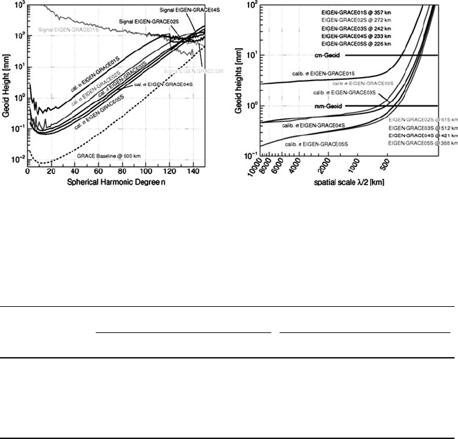
Figure 3 and Table 1 show the improvements of the calibrated errors of the static
and monthly EIGEN gravity field time series from the very first model EIGEN-
GRACE01S (RL00) to the r ecent solution EIGEN-GRACE05S (RL04).
It becomes obvious that (a) every new release results in an improved error level
(decreased degree variances towards the pre-launch simulated GRACE baseline
accuracy (Kim, 2000) and smaller accumulated errors) and (b) the relative improve-
ments of RL04 mentioned above with respect to the precursor models RL03 and
RL02 is relatively large (25 and 40% for the static field, 14.3 and 40% for the
monthly solutions, respectively). Nevertheless, EIGEN-GRACE05S is still a factor
of 7.5 (static field) and 15 (monthly solutions) above the baseline. Consequently, the
current background models and processing standards should be further investigated
and improved.
Fig. 3 Improvement of the static EIGEN gravity field time series in terms of degree variances
(left) and accumulated errors (right) from the very first model EIGEN-GRACE01S (RL00) to the
recent solution EIGEN-GRACE05S (RL04)
Table 1 Error level of the static and monthly GRACE-only EIGEN models in terms of
“factor above the pre-launch simulated baseline error” and “improvement with respect to precursor
solution in percent”
Model EIGEN- Static field Monthly fields
Factor (–) Improvement (%) Factor (–) Improvement (%)
GRACE01S ∼50.0 No monthly fields processed
GRACE02S ∼20.0 60.0 ∼40.0
GRACE03S ∼12.5 37.5 ∼25.0 37.5
GRACE04S ∼10.0 20.0 ∼17.5 30.0
GRACE05S ∼7.5 25.0 ∼15.0 14.3
The Release 04 CHAMP and GRACE EIGEN Gravity Field Models 47
EIGEN-GRACE05S monthly models are available in the GRACE ISDC at GFZ
(http://isdc.gfz-potsdam.de/grace) along with their calibrated errors and monthly
mean non-tidal mass variation products (GAA-GAD; Flechtner, 2007b).
3 Weekly EIGEN-GRACE05S Time Series
Parallel to the monthly EIGEN-GRACE05S time series GFZ has processed weekly
gravity field solutions in the framework of the German Research Foundation (DFG)
Special Priority Program SPP1257 “Mass Transports and Mass Distribution in the
Earth System” (Ilk et al., 2005) within the JIGOG project (surface mass redistribu-
tion from Joint Inversion of GPS site displacements, Ocean bottom pressure (OBP)
models, and GRACE gravity models, Rietbroek et al., 2009).
These models have the highest temporal resolution compared to all other pro-
cessing centres and will provide insight into mass variations which take place at
ten-daily or even shorter time scales such as barotropic Rossby waves, continental
water storage changes or solid Earth and ocean tides (Ilk et al., 2005). The models
are aligned to the GPS calendar week and complete to degree and order 30. These
maximum values are a result of a dedicated ground track analysis based on orbit
configuration (see also Fig. 2) and GRACE instrument data availability. The RL04
weekly solutions have been derived from 7-day batches of daily GRACE normal
equation systems using the same processing standards and background models as
applied for the monthly solutions. No further constraints have been applied.
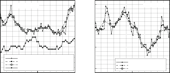
Time series of pure and pseudo-weekly (smoothed version from combination
with two down-weighted preceding and succeeding weekly products) solutions have
been compared to the corresponding results of the monthly RL04 GRACE gravity
models (see Fig. 4). Although the pure weekly solutions show a larger variability,
Year
ΔC
20
2006 2006.5 2007
–5E-10
0
5E-10
GFZ-RL 04 Pu re Weekly
GFZ-RL 04 Pseudo- Weekly
GFZ-RL 04 Monthly
GFZ-RL 04 LAGEOS Weekly Mov. Average
All values relative to
C
20
=–4.84165E–04
Year
ΔC
30
2006 2006.5 2007
–1E-10
0
1E-10
2E-10
GFZ-RL 04 Pure Weekly
GFZ-RL 04 Pseudo-Weekly
GFZ-RL 04 Monthl y
All values relative to
C
30
=
9.571E–07
Fig. 4 C
20
(left)andC
30
(right) spherical harmonic coefficients of EIGEN-GRACE05S monthly
and weekly gravity field products
48 F. Flechtner et al.
they generally agree well with the monthly solutions. For some weeks, larger devia-
tions (“outliers”) are visible which do not necessarily correlate with the results of the
ground track analysis. Therefore, it seems to be plausible that some of these outliers
rather represent physically induced signal than noise. The well-known “GRACE C
20
bias” e.g. when compared to the latest version of GFZ’s RL04 LAGEOS time series
is obvious and has still to be investigated.
Presently 306 pure weekly EIGEN-GRACE05S products for the period August
2002 till July 2008 are available. Only 7 weeks could not be derived due to
sparse GRACE L1B data. These models are available in the GRACE ISDC at GFZ
(http://isdc.gfz-potsdam.de/grace) along with their weekly mean non-tidal mass
variation products ( GAA-GAD; Flechtner, 2007b). The calibrated errors will be
provided soon. Further information on the processing method and validation of the
weekly products can be found in Schmidt et al. (2007) and Dahle et al. (2008).
4 Monthly EIGEN-CHAMP05S Time Series
All CHAMP data between October 2002 and September 2008 have been repro-
cessed using the EIGEN-GRACE05S background models, processing standards and
strategy described above. While the pure GRACE monthly gravity field solutions
can be estimated up to degree and order 120, the CHAMP monthly gravity fields
- due to the missing low-low SST link – are limited to degree and order 60 and
based on a moving average of three month of data. As for GRACE and in contrast
to previous CHAMP solutions, no regularization is applied.
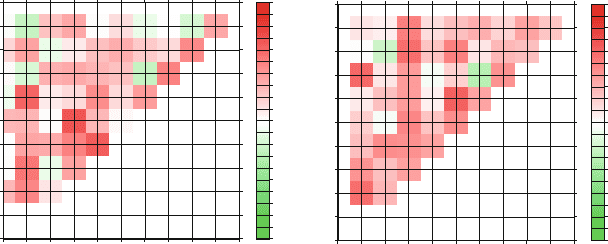
Figure 5 shows the correlation between the spherical harmonic coefficients of the
EIGEN-GRACE05S and EIGEN-CHAMP05S time series up to degree and order
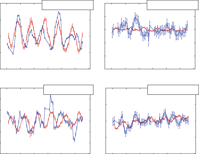
9. Figure 6 depicts selected results for the time series of four selected harmonics.
The GRACE error bars are the calibrated errors while for CHAMP still the formal
0
1
2
3
4
5
6
7
8
9
10
Degree
012345678910
Order
Correlation Matrix C
nm
–1.0
–0.9
–0.8
–0.7
–0.6
–0.5
–0.4
–0.3
–0.2
–0.1
0.0
0.1
0.2
0.3
0.4
0.5
0.6
0.7
0.8
0.9
1.0
0
1
2
3
4
5
6
7
8
9
10
Degree
012345678910
Order
Correlation Matrix S
nm
–1.0
–0.9
–0.8
–0.7
–0.6
–0.5
–0.4
–0.3
–0.2
–0.1
0.0
0.1
0.2
0.3
0.4
0.5
0.6
0.7
0.8
0.9
1.0
Fig. 5 Correlations between the spherical harmonic coefficients C
nm
(left)andS
nm
(right)ofthe
EIGEN-GRACE05S and EIGEN-CHAMP05S time series up to degree and order 9
The Release 04 CHAMP and GRACE EIGEN Gravity Field Models 49
–2
–1
0
1
2
2003 2004 2005 2006 2007 2008 2009
–3
–2
–1
0
1
2
2003 2004 2005 2006 2007 2008 2009
–3
–2
–1
0
1
2
3
2003 2004 2005 2006 2007 2008 2009
–2
–1
0
1
2
2003 2004 2005 2006 2007 2008 2009
10
10
(S
73
(t) − const.)
10
10
(C
91
(t) − const.)
10
10
(C
44
(t) − const.)
10
10
(S
42
(t) − const.)
Fig. 6 Time series of spherical harmonic coefficients C
44
(top left), C
91
(top right), S
42
(bot-
tom left)andS
73
(bottom right) from the EIGEN-GRACE05S and EIGEN-CHAMP05S monthly
gravity fields
errors from the gravity field solution are given. It is obvious that the majority of the
coefficients are highly correlated and the smaller the a-posteriori sigmas are for both
GRACE and CHAMP the higher the correlations are.
The EIGEN-CHAMP05S monthly models are available at the CHAMP ISDC at
GFZ (http://isdc.gfz-potsdam.de/champ). The still missing monthly models from
the beginning and end of the mission, the corresponding mean field, calibrated
errors and monthly mean non-tidal mass variation products (GAA-GAD; Flechtner,
2007b) will be provided soon.
5 Satellite-Only and Combined EIGEN-5S and EIGEN-5C
Solutions
The combined gravity field model EIGEN-5C is an upgrade of EIGEN-GL04C
(Förste et al., 2008a). The model represents a combination of GRACE and LAGEOS
mission data plus 0.5
◦
× 0.5
◦
gravimetric and altimetry surface data. The combi-
nation of the satellite and surface data has been done by the combination of normal
equations, which are obtained from observation equations for the spherical harmonic
coefficients.

50 F. Flechtner et al.
The satellite data have been provided by GFZ (EIGEN-GRACE05S static field
derived from monthly solutions between February 2003 and January 2007) and
GRGS (Groupe de Recherches Geodesie Spatiale) Toulouse (static field derived
from 10-daily GRACE solutions for the period August 2002 till January 2007 and
10-daily LAGEOS solutions for the period January 2002 till December 2006). The
GRGS processing standards and background models are, with minor differences
(e.g. the ocean model to correct short-term non-tidal mass variations is MOG2D;
Carrère and Lyard, 2003), nearly identical to EIGEN-GRACE05S.
The used surface data are identical to EIGEN-GL04C except of new gravity
anomaly data sets for Europe (H. Denker, IfE Hannover, 2007, personal commu-
nication), the Arctic Gravity Project gravity anomaly data (Forsberg and Kenyon,
2004) as updated in 2006 and newer Australian gravity anomalies (W. Featherstone,
Curtin University of Technology, 2008, personal communication). As the precursor
joint GFZ/GRGS combined gravity field models, EIGEN5-C is complete t o degree
and order 360 in terms of spherical harmonic coefficients which corresponds to a
spatial resolution of 55 km on the Earth’s surface. Also, a special band-limited nor-
mal equation combination method (Förste et al., 2008a) has been applied in order
to preserve the high accuracy from the satellite data in the lower frequency band of
the geopotential and to form a smooth transition to the high frequency information
coming from the surface data.
Independent comparisons with geoid heights determined point-wise by GPS
positioning and GPS levelling show notable improvements (Table 2). The results
given in this table have been derived for GPS/leveling points of the USA (Milbert,
1998), Canada (M. Véronneau, Natural Resources Canada, 2003, personal com-
munication), Germany (Ihde et al., 2002), Europe (Ihde, 2008, personal commu-
nication) and Australia (G. Johnston, Geoscience Australia and W. Featherstone,
Curtin University of Technology, 2007, personal communication). For this com-
parison, height anomalies were calculated from the spherical harmonic coefficient
data sets and reduced to geoid heights (c.f. Rapp, 1997). The topographic correction
was done by using the DTM2006.0 model, which is available in spherical harmonic
coefficients (Pavlis et al., 2007).
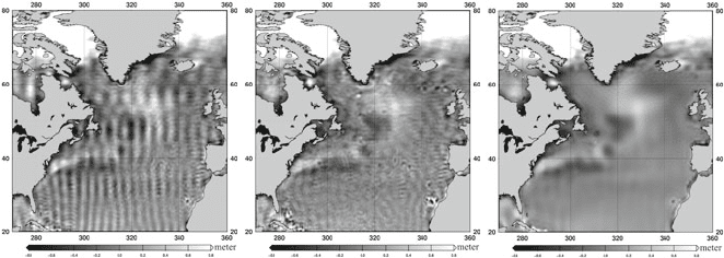
Also, the unrealistic meridional striping patterns over the oceans in the pre-
cursor EIGEN models could be much reduced (Fig. 7). Therefore, EIGEN-5C
and its associated satellite-only model EIGEN-5S have been selected as standard
for ESA’s official data processing of the upcoming gradiometer satellite mission
GOCE.
Table 2 Root mean square (rms) about mean of GPS-levelling minus gravity field model derived
geoid heights (cm) (number of points in brackets)
Gravity Model USA (6169) Canada (1930) Australia (201) Europe (1234) Germany (675)
EIGEN5C3425243015
EIGEN-GL04C 34 25 24 34 18
EIGEN-CG03C 35 31 26 36 20
EIGEN-CG01C 35 27 26 37 22
The Release 04 CHAMP and GRACE EIGEN Gravity Field Models 51
Fig. 7 North Atlantic geoid heights (scale ±0.8 m) of EIGEN-CG03C (left), EIGEN-GL04C
(middle) and EIGEN5C (right) after subtraction of a surface gravity data based geoid
The EIGEN-5C as well as the EIGEN-5S spherical harmonic coefficients
are available for download at the ICGEM (International Centre for Global
Earth Models) data base at GFZ Potsdam (http://icgem.gfz-potsdam.de). Further
details about these gravity field models as well as the coefficients can
be found at http://www-app2.gfz-potsdam.de/pb1/op/grace/results and in Förste
et al. (2009).
6 A New Mean, Static EIGEN-CHAMP05S Gravity Field
Model and Its Evaluation
The reprocessed CHAMP data have been used to compute a new mean, static
CHAMP-only gravity field model. This has been done by accumulating the men-
tioned monthly CHAMP normal equations from the time span between October
2002 and September 2008. The obtained mean EIGEN-CHAMP05S gravity field
model is of a maximum degree/order 150. Before solving the accumulated normal
equation system, the system has been stabilized by stochastic a-priori information
for all spherical harmonic coefficients with a degree l ≥ 70, because the gravita-
tional signal fades out for these higher degree terms. The stabilization, following
Kaula’s degree variance model (Kaula, 1966), constraints the resulting coefficients
towards a value of zero if there is no information at all in there observation data.
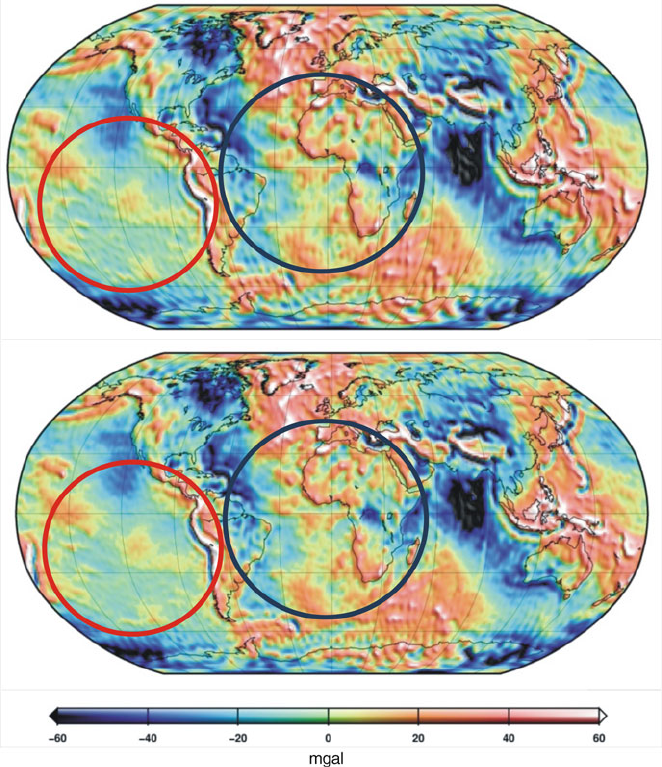
Figure 8 shows a global gravity anomaly plot of EIGEN-CHAMP05S in compar-
ison with its precursor CHAMP-only model EIGEN-CHAMP03S. The resolution
of the plotted grid is 1
◦
× 1
◦
. It can be seen from the comparison of these two
plots, that the unrealistic meridional stripes in EIGEN-CHAMP03S are significantly
reduced in the new EIGEN-CHAMP05S, in particular in the south pacific and south
atlantic regions as marked by the red and blue circles. This enhanced quality of
our new mean CHAMP-only model is assumed to be achieved by the mentioned
application of the improved RL04 background modelling, processing standards and
strategies.
52 F. Flechtner et al.
Fig. 8 Gravity anomaly plot (spatial resolution 1
◦
× 1
◦
) for the new mean EIGEN-CHAMP05S
(bottom) in comparison with EIGEN-CHAMP03S (top). The blue and red circles mark regions,
where the meridional stripes in EIGEN-CHAMP05S are obviously reduced w.r.t. EIGEN-
CHAMP03S
One measure of the long-to-medium wavelength accuracy of a gravity field
model is the fit of observations to the adjusted satellite orbit. Here we present
satellite laser ranging (SLR) residuals for CHAMP and GRACE arcs after an orbit
determination by using GPS-SST and accelerometer data (CHAMP and GRACE)
and K-Band Range-Rate data (GRACE), where the SLR measurements were not
included into the orbit adjustment. Table 3 gives the number of the included SLR
observations and the measurement time periods:
