Walker J. Facies models, Canada, 1992
Подождите немного. Документ загружается.

-
-
-
-
-
-
-
---
-
--
-
5. GLACIAL MODELS 77
base.
Such tunnel fill eskers are ex-
-reat as steep-sided
,
ridqes that record the internal plumbing
system of the ice sheet (Fig. 12):
Internally, the eskers contain cross-
bedded sand and gravel facies with re-
stricted variance in paleocurrent
directions. A beaded form is typical of
eskers deposited as overlapping sub-
aqueous fans in water ponded against
the retreating ice front. Beaded eskers
1
show rapid downstream~~ons
info
fine-grained glaciolacustrine facies.
Other
bedforms exposed by the
retreat of wet-based, sliding glaciers
are streamlined
drumlins,
which form
part of extensive swarms (Fig. 13).
Their formation is not well understood,
but most inferred mechanisms invoke
Internal deformation
either incremental lodgement around
subglacial obstacles such as rock
highs, or erosion of sediment over-run
by the ice sheet. Studies of drumlins at
modern ice margins, and geophysical
investigations in Antarctica (Alley
et
al.,
1987), show that subglacial sedi-
ments can be pervasively deformed
below rapidly flowing ice (Fig.
6D).
In
this case, sliding along the
icelsub-
.
strate interface is less important than
movement resulting from internal de-
formation of the substrate. These beds
are composed of diamicts (deforma-
tion till; Fig. 14) and formed by the me-
chanical mixing and homogenization
of eroded sediments, as in a concrete
mixer. Indeed, the glacier base can be
regarded as a giant shear zone, with
deformation till being equivalent to fault
gouge and drumlins as large-scale
slickensides. The thickness of the de-
forming layer below large Quaternary
ice sheets is not yet established, but
could have reached several tens of
metres. The deformability of sediments
overridden by the ice sheet is dictated
by their geotechnical and hydrogeo-
logical properties. Spatial variation in
the shear-strength of subglacial sub-
strate sediments gives rise to streams
of deforming
diamict separated by
areas of the bed that are resistant to
deformation (Fig.
15).
Erosion around
these more resistant portions of the
bed results in streamlined
residual
drumlins. Detailed subsurface investi-
gations show that many drumlins origi-
nate by erosion of pre-existing sedi-
ment, with deformation till resting
unconformably on a resistant core of
overridden proglacial sediments (Fig.
15; Boyce and Eyles, 1991). Other
models of drumlin genesis involve the
release of catastrophic subglacial sheet
floods (Shaw and Sharpe, 1987) but
this hypothesis has yet to be ade-
quately tested by studies of the internal
Figure
7
Glacially-shaped clasts. A)
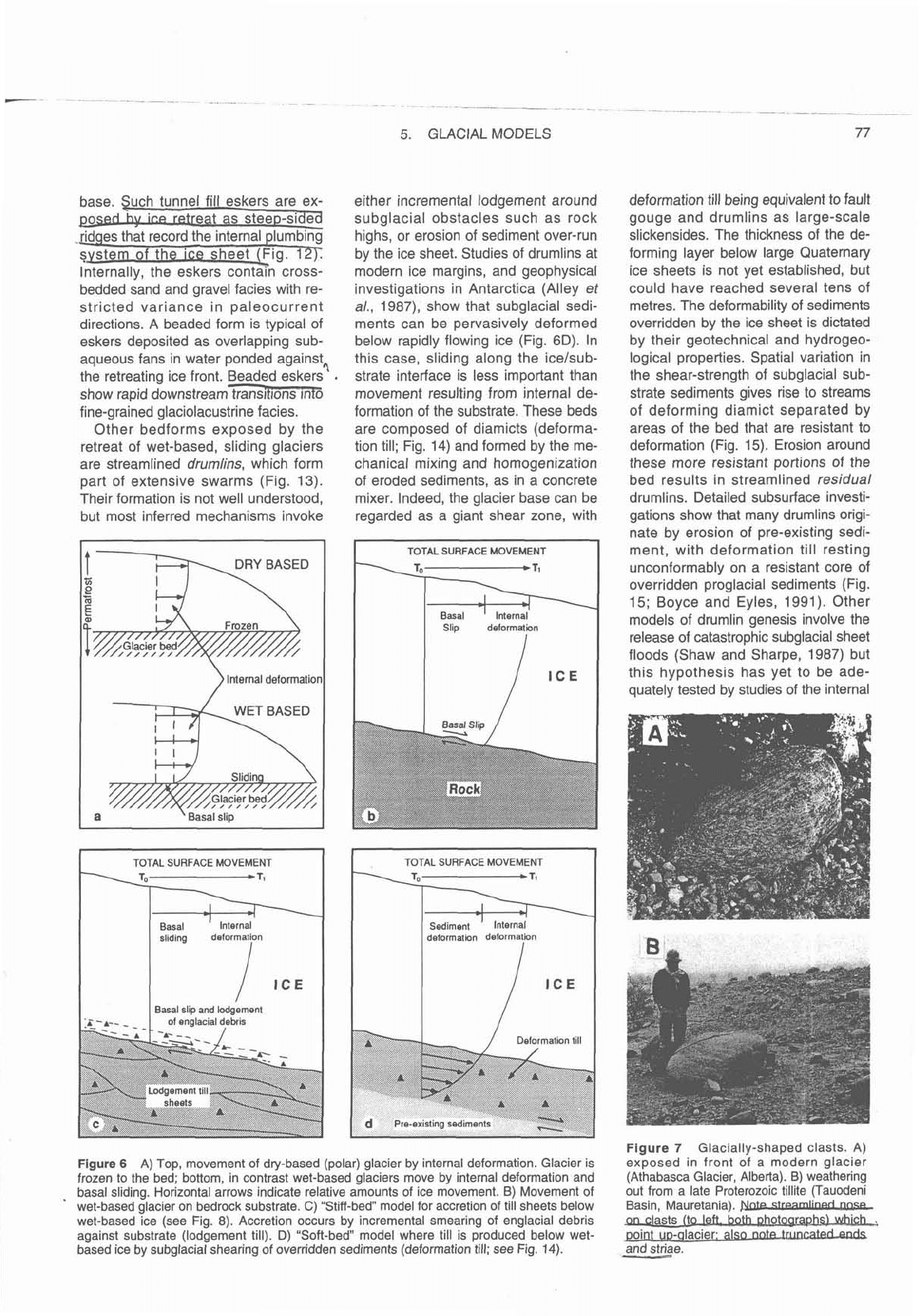
Figure 6
A) Top, movement of dry-based (polar) glacier by internal deformation. Glacier is
exposed in front of a modern
glacier
frozen to the bed; bottom, in contrast wet-based glaciers move by internal deformation and
(Athabasca Glacier, Alberta). B) weathering
basal sliding. Horizontal arrows indicate relative amounts of ice movement.
B)
Movement of
out from a late Proterozoic
tillite (Tauodeni
wet-based glacier on bedrock substrate.
C)
"Stiff-bed" model for accretion of till sheets below
Basin, Mauretania).
wet-based ice (see Fig.
8).
Accretion occurs by incremental smearing of englacial debris
an
clasts (to left.bothflhah,.,
against substrate (lodgement till).
D)
"Soft-bed" model where till is produced below wet-
point up-qlacier: also
nate-truncated-auk
based ice by subglacial shearing of overridden sediments (deformation till; see Fig.
14).
-
and striae.
78 EYLES, EYLES
structure and facies of the drumlins.
The important criteria for identifying
continental glacial facies are
1)
the
presence of underlying regionally ex-
tensive unconformities and 2) the re-
stricted regional thickness of individual
subglacially deposited
diamict(ite)
units. This thickness is generally less
than 50 m, and is commonly much less.
By contrast with the subglacial environ-
ment,
diamict(ite) thicknesses in glacio-
lacustrine and glaciomarine environ-
ments are much greater (see below).
The second criterion of restricted
regional thickness applies regardless of
the relative importance of lodgement
(stiff-bed) and deformation (deforming
bed) below the ice sheets (Fig. 6) and
regardless of the precise origin of
sub-
glacial bedforms. The presence or
absence of subglacial
bedforms (drum-
lins, eskers and glaciotectonic struc-
tures), subaerial
outwash and other
cold climate facies, provides further
contextual criteria for the identification
of subglacially deposited
till(ite)s.
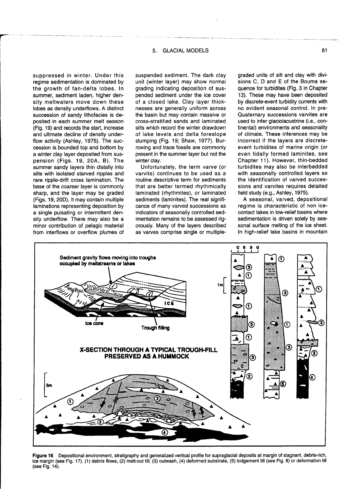
Supraglacial depositional system
The thin, outer margin of an ice sheet
commonly stagnates, leaving broad
zones of hummocky topography un-
derlain by highly variable sediments
with complex geometries. During the
last glaciation, stagnant ice extended
over many thousands of square
kilo-
metres in North America (Figs.
4, 5).
Strong compression between active ice
upglacier and the dam of stagnant
marginal ice results in complex folding
and thickening of the basal debris layer
(Fig. 16). This debris may be slowly
melted out in situ to form basal melt-out
till. The melt-out till, together with other
diamict facies released on the ice
surface, is associated with a distinct
hummocky topography that records
complex disintegration of the ice mar-
gin (Fig.
17D, E; Shaw, 1979; Lawson,
1982; Kasizcki, 1987; Paul and Eyles,
1990). If the thin outer margin of the ice
sheet becomes frozen to the substrate,
large bedrock slabs may be detached
and glaciotectonized. This is because
ice movement is accomplished not by
basal sliding, but by deformation of un-
derlying substrate sediments.
An inactive or retreating margin of
this type becomes buried under a
drape of diamict formed by the melt-out
of englacial debris on the ice surface
(Figs. 16,
17A,
B,
C).
This drape is
very unstable and is moved by sedi-
ment gravity flows into kettle basins
generated by the local melt of buried
ice (Boulton, 1972; Fig.
17b, c). Kettle
fills are subsequently preserved as
hummocks when adjacent ice cores,
under a thinner sediment cover, melt-
down more rapidly to produce topo-
graphic lows (relief-inversion). Typical
vertical profiles through hummocks
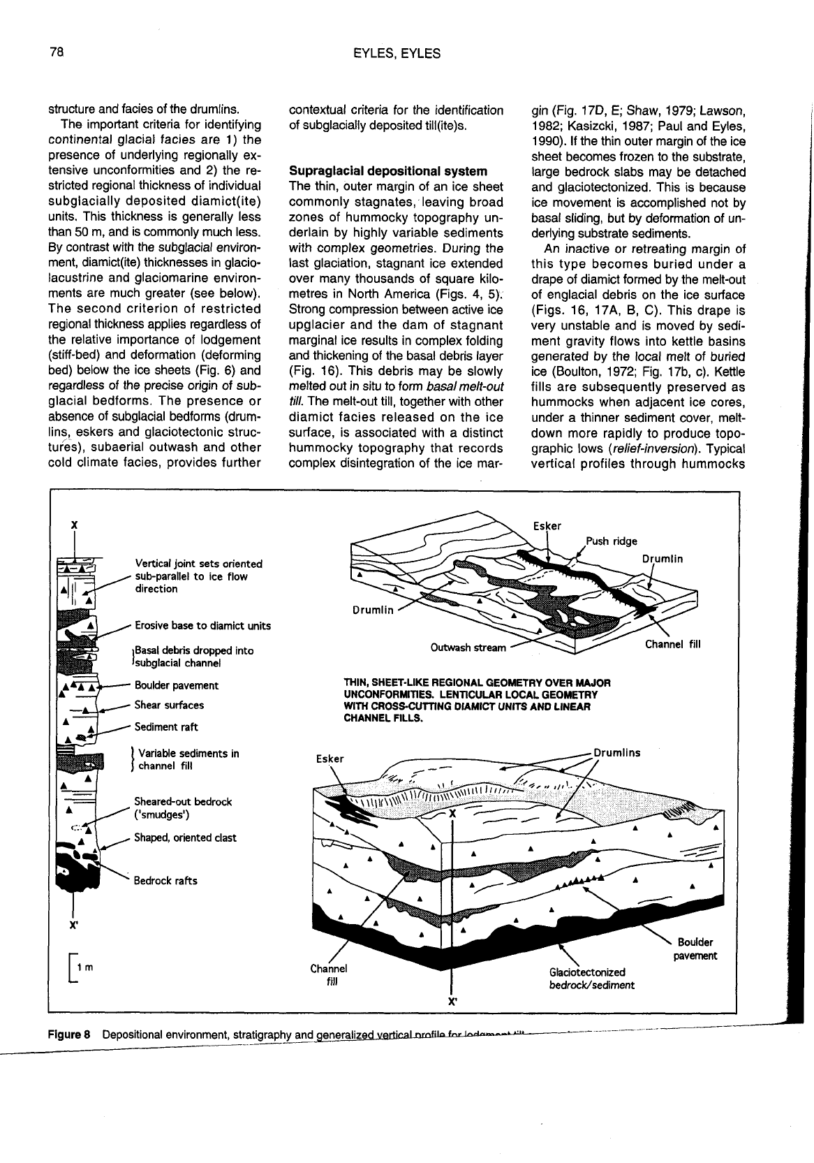
Vertical joint sets oriented
sub-parallel to ice flow
Erosive base to diarnict units
Outwash stream
THIN, SHEET-LIKE REGIONAL GEOMETRY OVER MAJOR
UNCONFORMITIES. LENTICULAR LOCAL GEOMETRY
Shear surfaces
WITH CROSS-CUTTING DIAMICT UNITS AND LINEAR
CHANNEL FILLS.
Variable sediments in
Sheared-out bedrock
Shaped, oriented clast
X'
X'
Figure
8
Depositional environment, stratigraphy andxn_eralized
pu
___
---
-
-_-
-----
..
-_
5.
GLACIAL MODELS
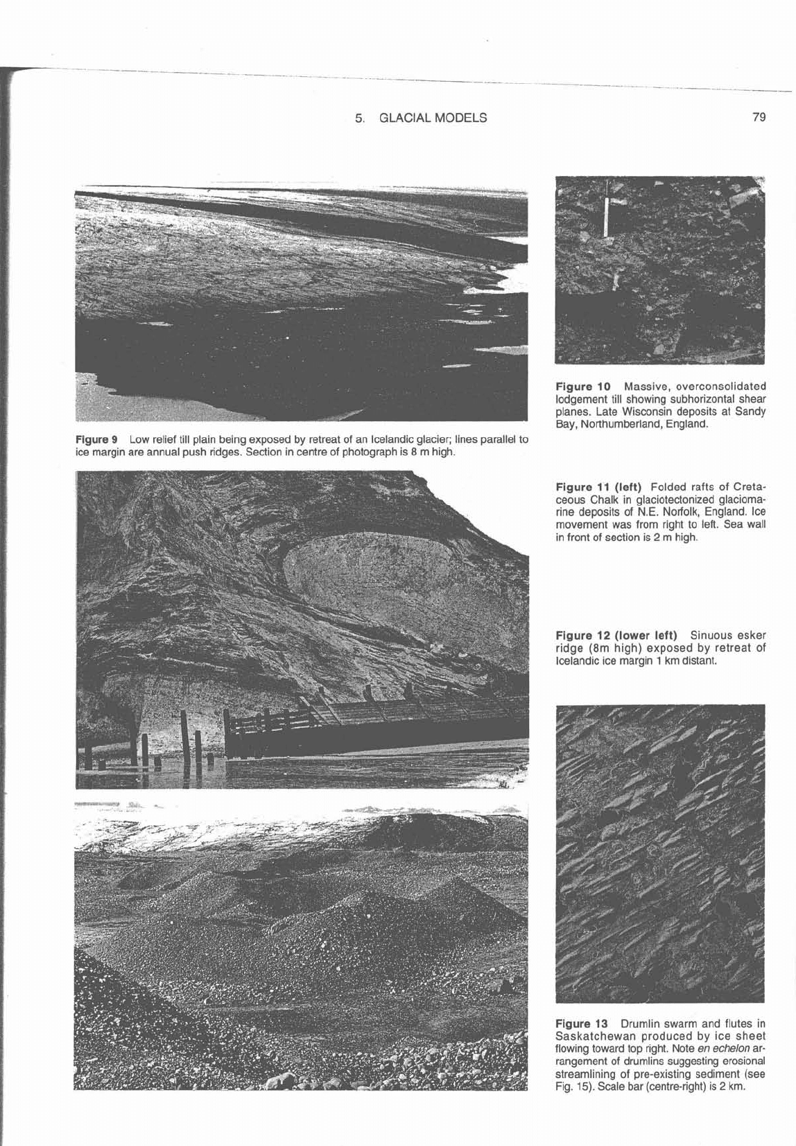
Figure
9
Low relief till plain being exposed by retreat of an Icelandic glacier; lines parallel to
ice margin are annual push ridges. Section in centre of photograph is
8
m high.
Day,
luurillullluallallu, cllylallu.
Figure
11
(left)
Folded rafts of Creta-
ceous Chalk in glaciotectonized glacioma-
rine deposits of N.E. Norfolk, England. Ice
movement was from right to left. Sea wall
in front of section is
2
m high.
Figure
12
(lower left)
Sinuous esker
ridge
(8m
high) exposed by retreat of
Icelandic ice margin
1
km distant.
Figure
13
Drumlin swarm and flutes in
Saskatchewan produced by ice sheet
flowing toward top right. Note
en echelon
ar-
rangement of drumlins suggesting erosional
streamlining of pre-existing sediment (see
Fig.
15).
Scale bar (centre-right) is
2
km.
show uppermost successions of resed-
imented massive, graded and stratified
diamicts (Fig. 16). Supraglacial dia-
micts resedimented as debris flows are
generally conformable, have clast im-
brication parallel to flow, clasts that
project from the tops of beds, rafts and
fragments of pre-existing sediments,
channelized cross sectional form,
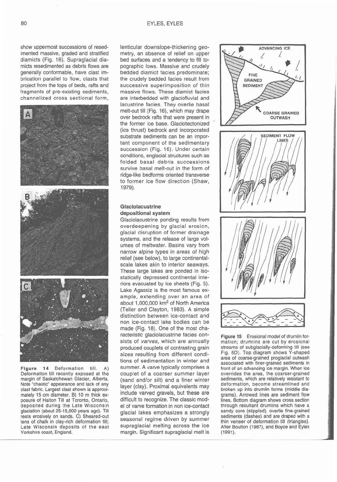
Figure
14
Deformation till. A)
Deformation till recently exposed at the
margin of Saskatchewan Glacier, Alberta.
Note "chaotic" appearance and lack of any
clast fabric. Largest clast shown is approxi-
mately 15 cm diameter. B) 10 m thick ex-
posure of
Halton Till at Toronto, Ontario,
deposited during the Late Wisconsin
glaciation (about 25-1 5,000 years ago). Till
rests erosively on sands.
C)
Sheared-out
lens of chalk in clay-rich deformation till;
Late Wisconsin deposits of the east
Yorkshire coast, England.
EYLES. EYLES
lenticular downslope-thickening geo-
metry, an absence of relief on upper
bed surfaces and a tendency to fill to-
pographic lows. Massive and crudely
bedded diamict facies predominate;
the crudely bedded facies result from
successive superimposition of thin
massive flows. These diamict facies
are interbedded with glaciofluvial and
lacustrine facies. They overlie basal
melt-out till (Fig.
16), which may drape
over bedrock rafts that were present in
the former ice base. Glaciotectonized
(ice thrust) bedrock and incorporated
substrate sediments can be an impor-
tant component of the sedimentary
succession (Fig.
16).
Under certain
conditions, englacial structures such as
folded basal debris successions
survive basal melt-out in the form of
ridge-like
bedforms oriented transverse
to former ice flow direction (Shaw,
1979).
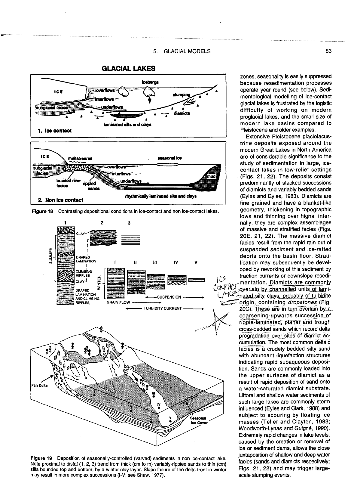
Glaciolacustrine
depositional system
Glaciolacustrine ponding results from
overdeepening by glacial erosion,
glacial disruption of former drainage
systems, and the release of large vol-
umes of meltwater. Basins vary from
narrow alpine types in areas of high
relief (see below), to large continental-
scale lakes akin to interior seaways.
These large lakes are ponded in iso-
statically depressed continental inte-
riors evacuated by ice sheets (Fig.
5).
Lake Agassiz is the most famous ex-
ample, extending over an area of
about 1,000,000 km2 of North America
(Teller and Clayton, 1983). A simple
distinction between ice-contact and
non ice-contact lake bodies can be
made (Fig. 18). One of the most cha-
racteristic
glaciolacustrine facies con-
sists of
varves,
which are annually
produced couplets of contrasting grain
sizes resulting from different condi-
tions of sedimentation in winter and
summer. A varve typically comprises a
couplet of a coarser summer layer
(sand
and/or silt) and a finer winter
layer (clay). Proximal equivalents may
include varved gravels, but these are
difficult to recognize. The classic mod-
el of varve formation in non ice-contact
glacial lakes emphasizes a strongly
seasonal regime driven by summer
supraglacial melting across the ice
margin. Significant supraglacial melt is
Figure
15
Erosional model of drumlin for-
mation; drumlins are cut by erosional
streams of subglacially-deforming till (see
Fig.
6D).
Top diagram shows Y-shaped
area of coarse-grained proglacial
outwash
associated with finer-grained sediments in
front of an advancing ice margin. When ice
overrides the area, the coarser-grained
sediments, which are relatively resistant to
deformation, become streamlined and
broken up into drumlin forms (middle dia-
grams). Arrowed lines are sediment flow
lines. Bottom diagram shows cross section
through resultant drumlins which have a
sandy core (stippled), overlie fine-grained
sediments (dashes) and are draped with a
thin veneer of deformation till (triangles).
After Boulton
(1987), and Boyce and Eyles
(1991).
suppressed in winter. Under this
regime sedimentation is dominated by
the growth of fan-delta lobes. In
summer, sediment laden, higher den-
sity meltwaters move down these
lobes as density underflows. A distinct
succession of sandy lithofacies is de-
posited in each summer melt season
(Fig. 19) and records the start, increase
and ultimate decline of density under-
flow activity (Ashley, 1975). The suc-
cession is bounded top and bottom by
a winter clay layer deposited from sus-
pension (Figs. 19, 20A, B). The
summer sandy layers thin distally into
silts with isolated starved ripples and
rare ripple-drift cross lamination. The
base of the coarser layer is commonly
sharp, and the layer may be graded
(Figs. 19,
200). It may contain multiple
laminations representing deposition by
a single pulsating or intermittent den-
sity underflow. There may also be a
minor contribution of pelagic material
from interflows or overflow plumes of
5. GLACIAL MODELS 81
suspended sediment. The dark clay
unit (winter layer) may show normal
grading indicating deposition of sus-
pended sediment under the ice cover
of a closed lake. Clay layer thick-
nesses are generally uniform across
the basin but may contain massive or
cross-stratified sands and laminated
silts which record the winter
drawdown
of lake levels and delta foreslope
slumping (Fig. 19; Shaw, 1977). Bur-
rowing and trace fossils are commonly
present in the summer layer but not the
winter clay.
Unfortunately, the term
varve
(or
varvite) continues to be used as a
routine descriptive term for sediments
that are better termed rhythmically
laminated (rhythmites), or laminated
sediments (laminites). The real signifi-
cance of many varved successions as
indicators of seasonally controlled sed-
imentation remains to be assessed rig-
orously. Many of the layers described
as varves comprise single or
multiple-
graded units of silt and clay with divi-
sions
C,
D and
E
of the Bouma se-
quence for turbidites (Fig. 3 in Chapter
13). These may have been deposited
by discrete-event turbidity currents with
no evident seasonal control. In
pre-
Quaternary successions varvites are
used to infer glaciolacustrine
(i.e., con-
tinental) environments and seasonality
of climate. These inferences may be
incorrect if the layers are
discrete-
event turbidites of marine origin (or
even tidally formed laminites, see
Chapter 11). However, thin-bedded
turbidites may also be interbedded
with seasonally controlled layers so
the identification of varved succes-
sions and varvites requires detailed
field study
(e.g., Ashley, 1975).
A seasonal, varved, depositional
regime is characteristic of non
ice-
contact lakes in low-relief basins where
sedimentation is driven solely by
sea-
.sonal surface melting of the ice sheet.
In high-relief lake basins in mountain
X-SECTION THROUGH A TYPICAL TROUGH-FILL
PRESERVED
AS
A HUMMOCK
Figure
16
Depositional environment, stratigraphy and generalized vertical profile for supraglacial deposits at margin of stagnant, debris-rich,
ice margin (see Fig. 17).
(1)
debris flows,
(2)
melt-out till,
(3)
outwash, (4) deformed substrate,
(5)
lodgement till (see
Fig.
8)
or deformation till
(see Fig. 14).
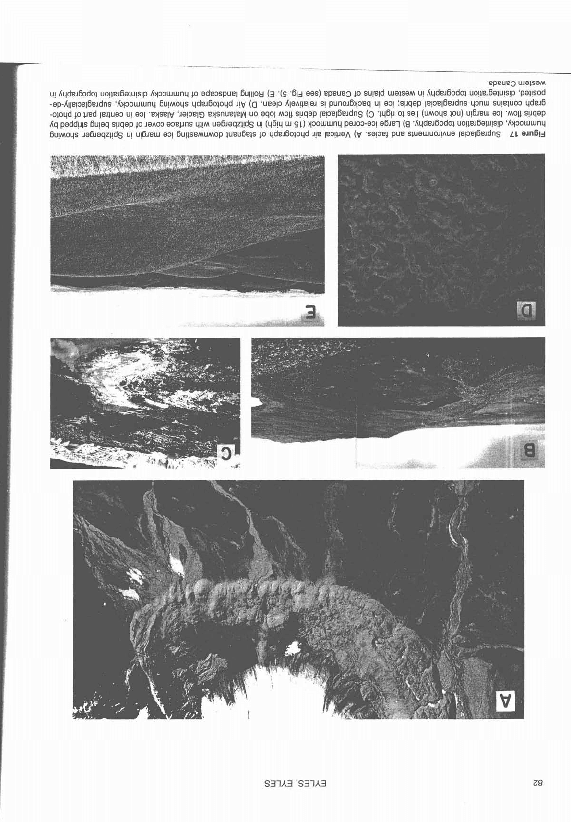
-
.
'EpEUeD UJalSaM
u! Aqde~6odol uo!l€?J6alu!s!p Ayaowwnq
p
adeospuel 6u!llo~
(3
'(9 '64 aas) epeue3
40
su!eld ulalsam u! Kqde~6odol uo!le~6alu!s!p 'pal!sod
-ap-Kllepel6e~dns 'Ayooururnq 6u!~oqs qde~601oqd ~!y
(a
.ueap Ala~!lela~ s! puno~6yoeq u! ao! !s!~qep la!3elBe~dns q3nur su!e)uoo qdw6
-oloqd lo ued le~luao u! aol .eysely 'JapelE) eysnueleyy uo aqol moll s!Jqap lepel6e~dns
(3
'w~!J 01 say (umoqs IOU) u!6~ew a31 .MO~) s!Jqap
Aq padd!~ls 6u!aq spqap
40
JaAoo a3epns 411~ ua6~aqzl!dg u! (46!4
w
91) ysowwnq pa~oo-ao! a6~e-l
(g
.Aqde~60dol uo!le~6aiu!s!p 'Ky3owurnq
~U!MO~S ua6~aqzl!ds u! U!~JRU a3! ~U!ISEMUMOP iueu6els
40
yde~6oloqd J!e Ie3!uaA
(V
'sape4 pue sluauruoJ!Aua 1e!oe16e~dns
LL
eln6lj
5.
GLACIAL MODELS 83
1.
Ico
contact
GLACIAL
LAKES
zones, seasonality is easily suppressed
because resedimentation processes
operate year round (see below).
Sedi-
mentological modelling of ice-contact
glacial lakes is frustrated by the logistic
difficulty of working on modern
proglacial lakes, and the small size of
modern lake basins compared to
Pleistocene and older examples.
Extensive Pleistocene
glaciolacus-
trine deposits exposed around the
modern Great Lakes in North America
are of considerable significance to the
study of sedimentation in large,
ice-
contact lakes in low-relief settings
(Figs. 21, 22). The deposits consist
predominantly of stacked successions
of diamicts and variably bedded sands
(Eyles and Eyles, 1983). Diamicts are
fine grained and have a blanket-like
Figure
18
Contrasting depositional conditions in ice-contact and non ice-contact lakes.
geometry, thickening in topographic
lows and thinning over highs. Inter-
1
2
3
nally, they are complex assemblages
of massive and stratified facies (Figs.
CLAY
-
20E, 21, 22). The massive diamict
facies result from the rapid rain out of
I
suspended sediment and ice-rafted
DRAP~D
debris onto the basin floor. Strati-
LAMINATION
I
I
11
111
IV
v
fication may subsequently be devel-
CLIMB~NG
oped by reworking of this sediment by
traction currents or downslope
resedi-
El
lL'
mentation. _qia.victs are commonly
DRAPED
5
~~~~;t)r~.o~iIC1by..~tja~
of lami-
LAMINATION
AND
CLIMBING
-SUSPENSION
-
ifl'"
~n~d~ays,.p~tur~
RIPPLES
GRAIN
FLOW
m
+Gorigin, containing dropstones (Fig.
-
TURBIDITY
CURRENT
-
20C). These are ~n~o~er~~
-!-
coarsening-upwards succession of
ripple-la$nated, phnai-an-da60ugh
cross-bedded sands which record delta
---
--
progradat.ion_ over-sites of diamictac-
cumulation. The most common deltaic-
.
.
--.-
facie~ isa crudely bedded silty sand
with abundant liquefaction structures
indicating rapid subaqueous deposi-
tion. Sands are commonly loaded into
the upper surfaces of diamict as a
result of rapid deposition of sand onto
a water-saturated diamict substrate.
Littoral and shallow water sediments of
such large lakes are commonly storm
influenced (Eyles and Clark, 1988) and
subject to scouring by floating ice
masses (Teller and Clayton, 1983;
Woodworth-Lynas and
Guignk, 1990).
Extremely rapid changes in lake levels,
caused by the creation or removal of
ice or sediment dams, allows the close
Figure
19
Deposition of seasonally-controlled (valved) sediments in non ice-contact lake.
juxtaposition of shallow and deep water
Note proximal to distal
(1,
2,
3)
trend from thick (cm to m) variably-rippled sands to thin (cm)
(sands
and
diamicts
respectively;
silts bounded top and bottom, by a winter clay layer. Slope failure of the delta front in winter
Figs.
21, 22) and may trigger large-
may result in more complex successions
(1- see
~haw,.1977). scale slumping events.

84
EYLES, EYLES
Glaciofluvial
deposits
The depositional systems described
above contain significant volumes of
sediment deposited by glacial melt-
water rivers (Fig.
23).
At the ice
margin, aggradation at the head of out-
wash fans is commonly rapid enough
to bury portions of the ice margin. This
leads to deformation structures in
coarse-grained, crudely bedded or
massive proximal
outwash gravels
when the buried ice subsequently
melts.
Outwash surfaces pitted (with
kettles
or
craters)
by the melt of buried
ice, may extend over many square kilo-
metres. They are flanked by eskers or
complex ice-contact diamict succes-
sions (Fig. 16).
The
outwash plain or
sandur
(plural:
sandar
in Icelandic) lies beyond the im-
mediate ice terminus. Glacial
outwash
rivers are typically of multiple-channel
(braided) type (Chapter
7).
Deposition
is commonly dominated by large floods
(jokulhlaups), to the extent that a single
flood event may accomplish most of the
sediment transport each year. Wind
action, in the absence of vegetation,
results in deposition of wind-blown
silts (loess) and sand (see below).
During early postglacial conditions,
swamps may become established in
the proximity of water bodies and
anastomosed river systems may
develop in areas experiencing glacio-
isostatic rebound and rising base level
(Chapter
7).
Thick peat accumulations
may ultimately generate coals, such
as those of the Permo-Carboniferous
Figure
20
Glaciolacustrine facies. A) Proximal varved sands (e.g., 1 in Fig.
19)
with winter clay layers arrowed. These facies were deposited
in a non ice-contact lake (Fraser River valley, British Columbia). B) Lowermost rippled sands with overlying draped lamination (silt) with winter
clay layers arrowed
(e.g.,
2
in Fig.
19).
Deposited in a non ice-contact lake (Glacial Lake Hitchcock, Massachussetts). C) Laminated silts and
clays containing abundant ice-rafted material. Some laminae show normal grading from silt to clay. Note variable thickness of laminae.
Deposited in an ice-contact lake; Don Valley Brickyard, Toronto, Ontario.
D)
Va~ed silts and clays deposited in Lake Agassiz, northern Ontario.
Note relatively constant thickness of laminations. Scale in cm; photograph courtesy T.
Warman.
E)
crudely stratified muddy diamict formed by
ice-rafting and settling of suspended fines in an ice-contact glaciolacustrine environment; photo shows about
1
m of outcrop. Late Wisconsin
deposits, Scarborough Bluffs, Ontario.
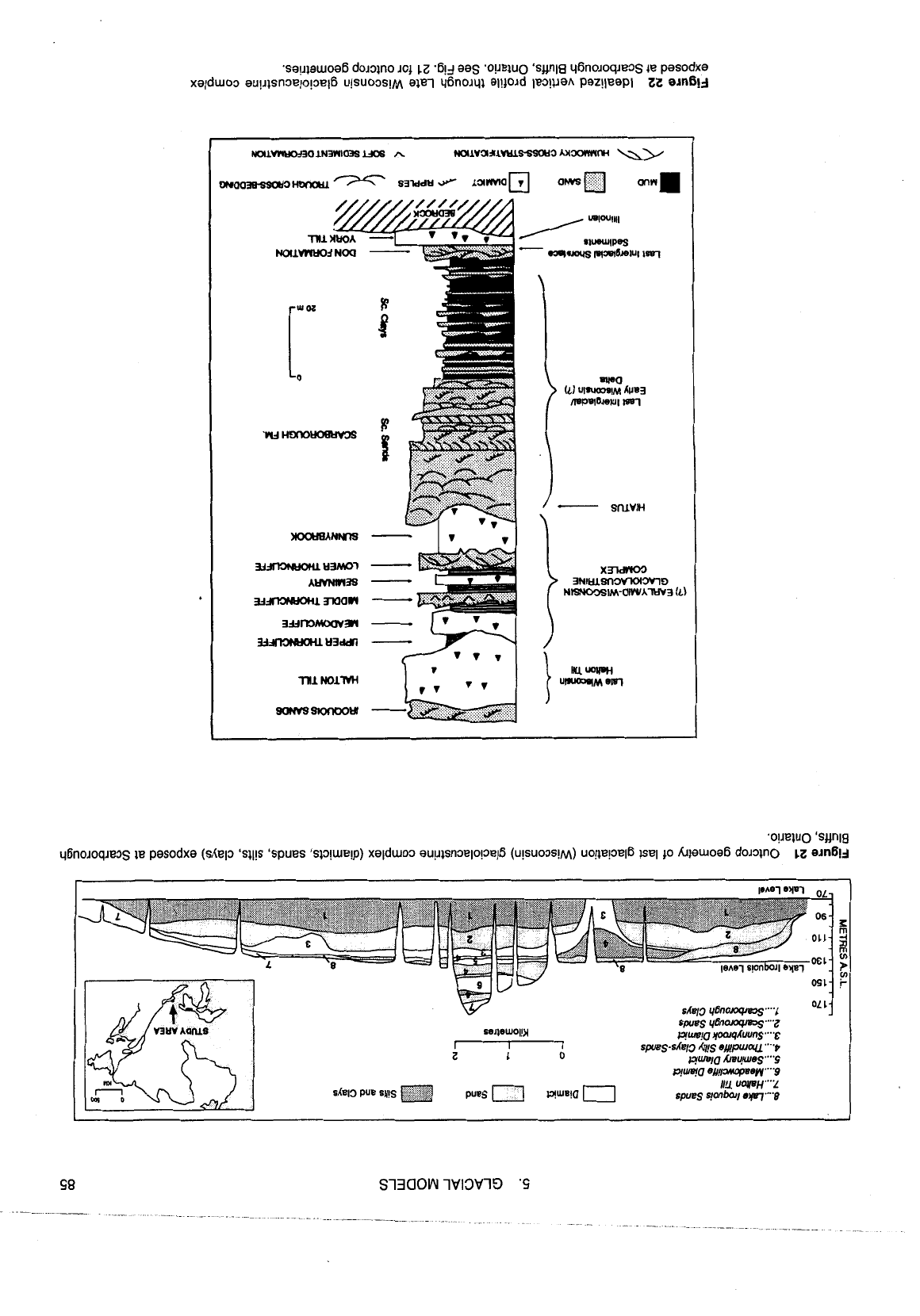
.sa!fiauoa6 dololno
JOJ
cz
.6!
j
eas .o!JeluO 'sunla y6no~oqeog la pasodxa
xalduoo au!~lsn3elo!oel6 u!suoos!~ elel y6noJyl al!)oJd lequah paz!leepl
am619
.o!leiuo 'sunla
qfinoroq~eos ie pewdxa (shelo 'sq!s 'spues 'su!ue!p) xalduoo au!~lsnoelo!oelB (u!suoos!~) uo!leps16 lsel
p
hiauoa6 doJan0
11
ernly
SL~D
yBnoiwms....I
OL
'
SpUBS
llBnoiwms"'Z
~uII)!~ yoaqAuuns
""E
spues-sLe/3 &I!S e#purocU
""P
gm!a kwu!weg"".s
qwqa
eU!I3MapU~ly""9
1/11 UWH""2
spues
qonbal/
ew."P
86 EYLES, EYLES
coal-bearing glaciated basins of the
southern continents (Martini and
Glooschenko, 1985).
Glaciofluvial processes are important
because they may completely rework
sediment deposited by the glacier (Fig.
23).
The sedimentary record indicating
the presence of ice may therefore be
destroyed. This is a problem in the inter-
pretation of ancient deposits, because
braided river deposits occur in many de-
positional settings (Chapter
7).
A
glacial
connection may be very difficult, if not
impossible to identify. Evidence must be
sought from the presence or absence of
cold climate (see below) periglacial
structures, or from the occurrence of
glacial clast shapes (Fig.
7)
and stria-
tions. This is a particular problem in
high-relief settings.
d
11
HIGH-RELIEF
GLACIOTERRESTRIAL SETTINGS
In mountainous areas typical of active
tectonic settings, steep substrate
slopes and valley floor rivers are the
dominant influence on sedimentation.
Late glacial resedimentation pro-
cesses rework primary glacial sedi-
ment downslope into braided river
systems or fan-deltas on the margins
of lakes. Deposits are dominated by
interbedded debris flow diamicts,
braided river gravels and
glaciolacus-
trine facies (Fig.
24)
and comprise a
relatively distinct
glaciated valley
depositional system. The term
para-
glacial
has been used to identify a
short-lived transitional period from
glacial to
fluvial environments (Ryder,
1971). Downslope transport of large
volumes of poorly sorted debris is
common, particularly in glaciated vol-
canic areas where large volumes of
coarse-grained poorly sorted volcanic
sediments are remobilized downslope
as
lahars
(
Eyles and Eyles, 1989; see
Chapter
6).
The presence of glacially
streamlined bullet
boulciers within a
diamict(ite) may be the only indication
of a glacial contribution to the sediment
Figure
24
High relief valley infill facies.
A) Late Wisconsin crudely bedded debris
flow diamictites cropping out along the Bow
Valley, Alberta. These deposits are prefer-
entially cemented and eroded into
steep-
sided pillars (hoodoos). Cliff approximately
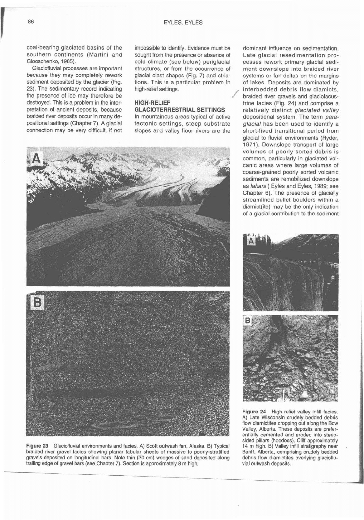
Figure 23 Glaciofluvial environments and facies. A) Scott outwash fan, Alaska. B) Typical
14
m high. B) Valley infill stratigraphy near
.
braided river gravel facies showing planar tabular sheets of massive to poorly-stratified
Banff, Alberta, comprising crudely bedded
gravels deposited on longitudinal bars. Note thin
(30
cm) wedges of sand deposited along
debris flow diamictites overlying
glacioflu-
trailing edge of gravel bars (see Chapter
7).
Section is approximately
8
m high.
vial
outwash deposits.