Richards J.A., Jia X. Remote Sensing Digital Image Analysis: An Introduction
Подождите немного. Документ загружается.

13.9 Spectral Unmixing: End Member Analysis 385
13.9
Spectral Unmixing: End Member Analysis
A challenge that has faced interpreters throughout the history of remote sensing has
been the need to handle mixed pixels – i.e. those pixels that represent a mixture of
cover types or information classes. Several early studies attempted to resolve the
proportions of pure cover types within mixed pixels by assuming that the measured
radiance is a linear combination of the radiances of the “pure” constituents in each
of the imaging wavebands used.
With low resolution (multispectral) data the approach generally did not meet with
a great deal of success because most cover types are not well differentiated in the
small number of wavebands used. However, with hyperspectral data, the prospect of
uniquely characterising a vast number of earth cover types, and thus differentiating
them from each other spectroscopically, suggests that the mixing approach should
be re-visited as a means for establishing mixture proportions of pure cover types in
pixels. This has particular relevance in minerals mapping where abundance maps for
minerals of interest can then be produced based upon the proportions determined for
all pixels in a given image.
The process can be developed mathematically in the following manner. Assume
there are M pure cover types in the image of interest. In the nomenclature of mixing
models these are referred to as endmembers. Let the proportions of the various
endmembers in a pixel be represented by f
m
,m= 1,...M. These are the unknowns
in the process which we wish to find, based on observation of the hyperspectral
reflectance of the pixel.
Let R
n
,n = 1,...N be the observed reflectance of the pixel in the n
th
spectral
band of the sensor and a
n,m
be the spectral reflectance in the n
th
band of the m
th
endmember. Then we assume
R
n
=
M
m=1
f
m
a
n,m
+ ξ
n
n = 1,...N
where ξ
n
is an error in band n. The equation says that the observed reflectance in each
band is the linear sum of the reflectances of the endmembers; the extent to which
that does not work exactly in a given situation is encapsulated in the error term.
An assumption that allows us to use linear mixing in this form is that the incident
energy is scattered only once to the sensor from the landscape and does not undergo
multiple scatterings among, for example, foliage components.
The above mixing equation can be expressed in matrix form as
R = Af + ξ
where f is a column vector of size M,R and ξ are column vectors of size N and A
is an N × M matrix of endmember spectral signatures (by column).
Spectral unmixing, as the process is called, involves finding a set of endmember
proportions that will minimise the error vector ξ. On the assumption that the correct
set of endmembers has been chosen the problem then becomes one of solving the
simpler equation
386 13 Interpretation of Hyperspectral Image Data
R = Af
Normally there are more equations than unknowns so that simple inversion of the
last equation to find the vector of mixing proportions is not possible. Instead, a least
squares solution is found by using the pseudo inverse
f = (A
t
A)
−1
A
t
R .
It should be mentioned that there are two constraints that the mixing proportions of
the endmembers are expected to satisfy. The first is that the proportions should sum
to unity and the second is that they should all be non-negative:
M
m=1
f
m
= 1
0 ≤ f
m
≤ 1 for all m
As discussed by Gross and Schott (1998) these constraints are sometimes violated
if the endmembers are derived from average cover type spectra or the endmember
selection is poor.
References for Chapter 13
Information on radiometrie correction of imaging spectrometer data using atmospheric and
solar curve models can be found in Gao et al. (1993). Roberts et al. (1985, 1986) can be
consulted for details of the empirical line and flat field methods of correction, while Green
and Craig (1985) develop the Log Residuals technique in detail.
Piech and Piech (1987) have proposed a general method to detect all the absorption features
in a pixel spectrum automatically and order them by their depth. The original spectrum is
convolved with Gaussian masks over a range of standard deviations (called scale parameters).
In so doing, absorption features disappear with increasing scale parameter and, as a result, a set
of progressively smoothed spectra is obtained. Then, the derivative of the smoothed spectrum
is calculated and the zero crossings indicate the local minima.
Clark (2003) develops this approach further, and uses expert systems to assist in the
identification.
Binary coding of hyperspectral imagery is treated in Mazer et al. (1988), Vane and Goetz
(1993), Jia (1996) and Jia and Richards (1993), while Jia (1996) and Jia and Richards (1994)
cover the block based methods for treating data of such high dimensionality.
The problem of small training sets is treated in detail by Landgrebe (2003) who also
demonstrates that unlabelled pixels can be used to supplement labelled training data in an
endeavour to develop more reliable training statistics for Bayesian classification.
G.P. Anderson, J. Wang and J.H. Chetwynd, 1995: MODTRAN3: An Update and Recent
Validations Against Airborne High Resolution Interferometer Measurements, 5th Annual
JPL Airborne Sciences Workshop, Vol 1 (AVIRIS Workshop), 5–8.
R.N. Clark, G.A. Swayze, K.E. Livo, R.F. Kokaly, S.J. Sutley, J.B. Dalton, R.R. McDougal
and C.A. Gent, 2003: Imaging Spectroscopy: Earth and Planetary Remote Sensing with
the USGS Tetracorder and Expert Systems. J. Geophysical Research, 108, E12, 5.1–5.44.
Problems 387
B.C. Gao, K.B. Heidebrecht andA.F.H. Goetz, 1992:Atmospheric Removal Program (ATREM)
Users Guide, Centre for the Study of Earth from Space, University of Colorado, Boulder.
B.C. Gao, K.B. Heidebrecht and,A.F.H. Goetz, 1993: Derivation of Scaled Surface Reflectance
from AVIRIS Data, Remote Sensing of Environment, 44, 165–178.
A.A. Green and M.D. Craig, 1985: Analysis of Aircraft Spectrometer Data with Logarith-
mic Residuals, Proc. AIS workshop, JPL Publication 85–41, Jet Propulsion Laboratory,
Pasadena, California, April 8–10, 111–119.
H.N. Gross and J.R. Schott, 1998. Application of Spectral Mixture Analysis and Image Fusion
Techniques for Image Sharpening. Remote Sensing of Environment, 63, 85–94.
X. Jia, 1996: Classification Techniques for Hyperspectral Remote Sensing Image Data, PhD
Thesis, School of Electrical Engineering, University College, ADFA, The University of
New South Wales.
X. Jia and J.A. Richards, 1993: Binary Coding of Imaging Spectrometer Data for Fast Spectral
Matching and Classification, Remote Sensing of Environment, 43, 47–53.
X. Jia and J.A. Richards, 1994: Efficient Maximum Likelihood Classification for Imaging
Spectrometer Data Sets, IEEE Trans on Geoscience and Remote Sensing, 32, 274–281.
D.A. Landgrebe, 2003: Signal Theory Methods in Multispectral Remote Sensing, N.J., Wiley.
F.A. Kruse, A.B. Letkoff, J.W. Boardman, K.B. Heidebrecht, A.T. Shapiro, P.J. Barloon and
A.F.H. Goetz, 1993: The Spectral Image Processing System (SIPS) – interactive visual-
isation and analysis of imaging spectrometer data, Remote Sensing of Environment, 44,
145–163.
A.S. Mazer, M. Martin, M. Lee and J.E. Dolomon, 1988: Image Processing Software for
Imaging Spectrometry Data Analysis, Remote Sensing of Environment, 24, 201–211.
M.A. Piech and K.R. Piech, 1987: Symbolic Representation of Hyperspectral Data, Applied
Optics, 26, 4018–4026.
K.R. Rao and P. Yip, 1990: Discrete Cosine Transform. New York: Academic.
D.A. Roberts,Y.Yamaguchi and R.J.P. Lyon, 1985: Calibration of Airborne Imaging Spectrom-
eter Data to Percent Reflectance Using Field Spectral Measurements, 19th International
Symposium on Remote Sensing of Environment, Ann Arbor, Michigan, October 21–25.
D.A. Roberts, Y. Yamaguchi and R.J.P. Lyon, 1986: Comparison of Various Techniques for
Calibration of AIS Data, in Proceedings, 2nd AIS workshop, JPL Publication 86-35, Jet
Propulsion Laboratory, Pasadena, California, 21–30.
M.J. Ryan and J.F. Arnold, 1997a: The Lossless Compression of AVIRIS Images by Vector
Quantization. IEEE Trans Geoscience and Remote Sensing, 35, 546–550.
M.J. Ryan and J.F. Arnold, 1997b: Lossy Compression of Hyperspectral Data Using Vector
Quantization. Remote Sensing of Environment, 61, 419–436.
P.N. Slater, 1980: Remote Sensing: Optics and Optical Systems. Reading Mass: Addison-
Wesley.
P.H. Swain and S.M. Davis (eds.), 1978: Remote Sensing: The Quantitative Approach, New
York: McGraw-Hill.
G. Vane and A.F.H. Goetz, 1993: Terrestrial Imaging Spectrometry: Current Status, Future
Trends, Remote Sensing of Environment, 44, 117–126.
Problems
13.1 The block based maximum likelihood classification scheme of Sect. 13.5.2 requires deci-
sions to be taken about what blocks to use. From your knowledge of the spectral responses of
388 13 Interpretation of Hyperspectral Image Data
the three common ground cover types of vegetation, soil and water, recommend an acceptable
set of block boundaries that might always be used with AVIRIS data. You may wish also to
take note of the major water absorption features in AVIRIS spectra as seen in Fig. 1.9.
13.2 Using the results of question 1 or otherwise discuss how the canonical analysis transfor-
mation might take advantage of partitioning the covariance matrices into blocks.
13.3 Does partitioning the covariance matrix into blocks assist minimum distance classifica-
tion?
13.4 (a) Consider the block based approach to principal components analysis as developed in
Sect. 13.6.2. Suppose several stages of transformation without feature reduction are used as
depicted in Fig. 13.15. Prove that the overall data variance after the final transformation is the
same as that generated had a single stage principal components transform been carried out.
(b) (This requires significant matrix analysis skills) As in part (a), but, a principal components
transform without segmentation is finally performed on the data which are obtained after
several stages of segmented principal components transform (without feature reduction) are
used. Prove that the data variance of each feature is the same as that generated had conventional
PCT been carried out for the original data.
13.5 Consider the simple binary coding scheme (with one threshold) developed in
Sect. 13.4.3.1 and illustrated in Fig. 13.10. How many distinct codes are possible for AVIRIS,
TM and SPOT HRV data sets? Why would binary codes not be a sufficient representative form
for SPOT and MSS data?
13.6 Suppose a particular image contains just two cover types – vegetation and soil. A pixel
identification exercise is carried out to attempt to attach either a soil or vegetation label to
each pixel and thereby come up with an estimate of the proportion of vegetation in the region
being imaged. From homogeneous regions of the image it is possible easily to label pure soil
and pure vegetation pixels. Clearly the image also contains a number of mixed pixels and so
end member analysis is considered as a means for resolving their soil/vegetation proportions.
Is the additional work justified if the approximate proportion of vegetation to soil is 1:100,
50:50 or 100:1?
13.7 Explain the concept of transmittance and name the main gases which cause markedly
low atmospheric transmittance at wavelength(s) between 400–2400 nm.
13.8 Describe briefly spectral library searching techniques, stating why they are feasible to
use with imaging spectrometer data and noting their advantages over statistical classification
methods.
13.9 The principal components transform and the Bhattacharyya distance can both be used
for band reduction. Comment on the main differences between the two methods for this
application.
13.10 Two-threshold coding is normally not recommended. Explain why.
13.11 When three-threshold coding is used, make suggestions on how to define the three
thresholds, particularly the upper and lower thresholds if the mean brightness value over the
spectrum is used as the middle threshold.
13.12 In the spectral angle mapper technique, the angle of a pixel vector in the spectral space
needs to be determined (Fig. 13.8). Write down the formula for calculating the angle for the
general case with N bands.
Appendix A
Missions and Sensors
This appendix contains descriptive and technical information on satellite and aircraft
missions and the characteristics of their sensors. It commences by looking briefly at
those programs intended principally for gathering weather information, and proceeds
to missions for earth observational remote sensing, including hyperspectral and radar
platforms and sensors.
Sufficient detail is given on data characteristics so that implications for image
processing and analysis can be understood. In most cases mechanical and signal
handling properties are not given, except for a few historical and illustrative cases.
A.1
Weather Satellite Sensors
A.1.1
Polar Orbiting and Geosynchronous Satellites
Two broad types of weather satellite are in common use. One is of the polar orbiting,
or more generally low earth orbit, variety whereas the other is at geosynchronous
altitudes. The former typically have orbits at altitudes of about 700 to 1500 km
whereas the geostationary altitude is approximately 36,000 km (see Appendix B).
Typical of the low orbit satellites are the current NOAA series (also referred to
as Advanced TIROS-N, ATN), and their forerunners the TIROS, TOS and ITOS
satellites. The principal sensor of interest from this book’s viewpoint is the NOAA
AVHRR. This is described in Sect. A.1.2 following.
The Nimbus satellites, while strictly test bed vehicles for a range of meteoro-
logical and remote sensing sensors, also orbited at altitudes of around 1000 km.
Nimbus sensors of interest include the Coastal Zone Colour Scanner (CZCS) and the
Scanning Multichannel Microwave Radiometer (SMMR). Only the former is treated
below.

390 A Missions and Sensors
Geostationary meteorological satellites have been launched by the United States,
Russia, India, China, ESA and Japan. These are placed in equatorial geosynchronous
orbits.
A.1.2
The NOAA AVHRR (Advanced Very High Resolution Radiometer)
TheAVHRR has been designed to provide information for hydrologic, oceanographic
and meteorologic studies, although data provided by the sensor does find application
also to solid earth monitoring. An earlier version of the AVHRR contained four wave-
length bands. Table A.1 however lists the bands available on the current generation
of instrument (NOAA 17).
Table A.1. NOAA advanced very high resolution radiometer
Spatial resolution 1.1 km at nadir
Dynamic range 10 bit
Swath width 2399 km
Spectral bands:
channel 1 0.58 − 0.68
µm
channel 2 0.725 − 1.0
µm
channel 3 3.55 − 3.93
µm
channel 3a 1.58 − 1.64
µm
channel 4 10.3 − 11.3
µm
channel 5 11.5 − 12.5
µm
A.1.3
The Nimbus CZCS (Coastal Zone Colour Scanner)
The CZCS was a mirror scanning system, carried on Nimbus 7, designed to mea-
sure chlorophyll concentration, sediment distribution and general ocean dynamics
including sea surface temperature. Its characteristics are summarised in Table A.2.
Table A.2. Nimbus coastal zone colour scanner
Spatial resolution 825 m at nadir
Dynamic range 8 bit
Swath width 1566 km
Spectral bands:
channel 1 0.433 − 0.453
µm
channel 2 0.510 − 0.530
µm
channel 3 0.540 − 0.560
µm
channel 4 0.660 − 0.680
µ
m
channel 5 0.700 − 0.800
µm
channel 6 10.5 − 12.5
µm

A.2 Earth Resource Satellite Sensors in the Visible and Infrared Regions 391
A.1.4
GMS VISSR (Visible and Infrared Spin Scan Radiometer)
and GOES Imager
Geostationary meteorological satellites such as GMS (Japan) and the earlier GOES
(USA) are spin stabilized with their spin axis oriented almost north-south. The pri-
mary sensor on these, the VISSR, scans the earth’s surface by making use of the
satellite spin to acquire one line of image data (as compared with an oscillating mir-
ror in the case of AVHRR, CZCS, MSS and TM sensors), and by utilizing a stepping
motor to adjust the angle of view on each spin to acquire successive line of data
(on orbiting satellites it is the motion of the vehicle relative to the earth that dis-
places the sensor between successive scan lines). The characteristics of the VISSR
are summarised in Table A.3.
The most recent GOES environmental satellites are 3 axis stabilised and carry a
GOES Imager with characteristics as shown in Table A.3.
Table A.3. VISSR and GOES Imager characteristics
Band Spatial resolution Dynamic range
(
µm) at nadir (km) (bits)
VISSR 0.55 – 0.90 1.25 6
(visible)
6.7 – 7.0 5 8
10.5 – 11.5 5 8
11.5 – 12.5 5 8
(thermal infrared)
GOES Imager 0.55 – 0.75 1 10
3.80 – 4.00 1 10
6.50 – 7.00 1 10
10.20 – 11.20 1 10
11.50 – 12.50 1 10
A.2
Earth Resource Satellite Sensors
in the Visible and Infrared Regions
A.2.1
The Landsat System
The Landsat earth resources satellite system was the first designed to provide near
global coverage of the earth’s surface on a regular and predictable basis.
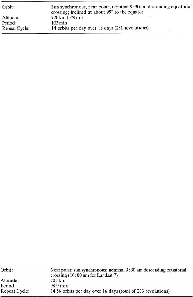
The first three Landsats had identical orbit characteristics, as summarised in
Table A.4. The orbits were near polar and sun synchronous – i.e., the orbital plane
precessed about the earth at the same rate that the sun appears to move across the

392 A Missions and Sensors
Table A.4. Landsat 1, 2, 3 orbit characteristics
face of the earth. In this manner data was acquired at about the same local time on
every pass.
All satellites acquired image data nominally at 9:30 a.m. local time on a descend-
ing (north to south) path; in addition Landsat 3 obtained thermal data on a night-time
ascending orbit for the few months that its thermal sensor was operational. Fourteen
complete orbits were covered each day, and the fifteenth, at the start of the next day,
was 159 km advanced from orbit 1, thus giving a second day coverage contiguous
with that of the first day. This advance in daily coverage continued for 18 days and
then repeated. Consequently complete coverage of the earth’s surface was given,
with 251 revolutions in 18 days.
The orbital characteristics of the second generation Landsats, commencing with
Landsats 4 and 5, are different from those of their predecessors. Again image data
is acquired nominally at 9:30 a.m. local time in a near polar, sun synchronous orbit;
however the spacecraft are at the lower altitude of 705 km. This lower orbit gives a
repeat cycle of 16 days at 14.56 orbits per day. This corresponds to a total of 233
revolutions every cycle. Table A.5 summarises the Landsat 4, 5 orbit characteristics.
Unlike the orbital pattern for the first generation Landsats, the day 2 ground pattern
for Landsats 4 and 5 is not adjacent and immediately to the west of the day 1 orbital
pattern. Rather it is displaced the equivalent of 7 swath centres to the west. Over
16 days this leads to the repeat cycle.
Landsat 6, launched in 1993, was not successfully placed in orbit and was lost
over the Atlantic Ocean. Landsat 7 is a similar satellite in all respects.
Whereas Landsats 1, 2 and 3 contained on-board tape recorders for temporary
storage of image data when the satellites were out of view of earth stations, Landsats 4
and 5 do not, and depend on transmission either to earth stations directly or via the
geosynchronous communication satellite TDRS (Tracking and Data Relay Satellite).
TDRS is a high capacity communication satellite that is used to relay data from a
Table A.5. Orbit parameters for Landsats 4, 5, 7

A.2 Earth Resource Satellite Sensors in the Visible and Infrared Regions 393
number of missions, including the Space Shuttle. Its ground receiving station is in
White Sands, New Mexico from which data is relayed via domestic communication
satellites. Landsat 7 also uses TDRS for data downlinking but has an on-board solid
state recorder for temporary storage.
A.2.2
The Landsat Instrument Complement
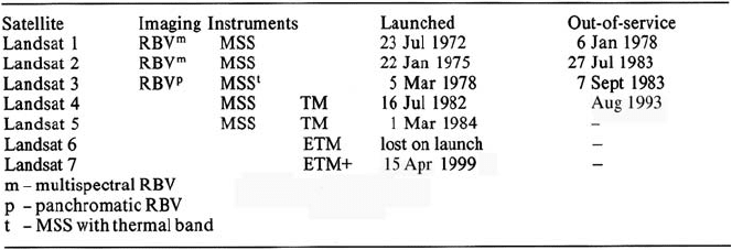
Three imaging instruments have been used with the Landsat satellites to date. These
are the Return Beam Vidicon (RBV), the Multispectral Scanner (MSS) and the The-
matic Mapper (TM). Table A.6 shows the actual imaging payload for each satellite
along with historical data on launch and out-of-service dates. Two different RBV’s
were used: a multispectral RBV package was incorporated on the first two satellites,
while a panchromatic instrument with a higher spatial resolution was used on Land-
sat 3. The MSS on Landsat 3 also contained a thermal band; however this operated
only for a few months.
Table A.6. Landsat payloads, launch and out of service dates
The MSS was not used after Landsat 5. With the launch of Landsat 7 an Enhanced
Thematic Mapper + (ETM+) was added.
The following sections provide an overview of the three Landsat instruments,
especially from a data characteristic point-of-view.
A.2.3
The Return Beam Vidicon (RBV)
As the name suggests the RBV’s were essentially television camera-like instruments
that took “snapshot” images of the earth’s surface along the ground track of the
satellite. Image frames of 185 km ×185 km were acquired with each shot, repeated
at 25 s intervals to give contiguous frames in the along track direction at the equivalent
ground speed of the satellite.

394 A Missions and Sensors
Three RBV cameras were used on Landsats 1 and 2, distinguished by different
transmission filters that allowed three spectral bands of data to be recorded as shown
in Table A.7. On Landsat 3 two RBV cameras were used; however both operated
panchromatically and were focussed to record data swaths of 98 km, overlapped to
give a total swath of about 185 km. By so doing a higher spatial resolution of 40 m
was possible, by comparison to 80 m for the earlier RBV system.
Historically the spectral ranges recorded by the RBV’s on Landsats 1 and 2 were
referred to as bands 1, 2 and 3. The MSS bands (see following) in the first generation
of Landsats were numbered to follow on in this sequence.
A.2.4
The Multispectral Scanner (MSS)
The Multispectral Scanner was the principal sensor on Landsats 1, 2 and 3 and was
the same on each spacecraft with the exception of an additional band on Landsat 3.
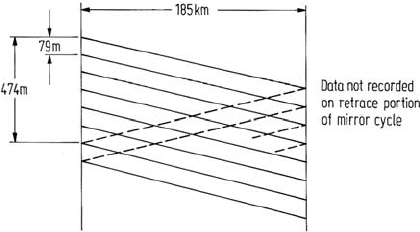
The MSS is a mechanical scanning device that acquires data by scanning the earth’s
surface in strips normal to the satellite motion. Six lines are swept simultaneously
by an oscillating mirror and the reflected solar radiation so monitored is detected
in four wavelength bands for Landsats 1 and 2, and five bands for Landsat 3, as
shown in Table A.7. A schernatic illustration of the six line scanning pattern used
by the MSS is shown in Fig. A.1. It is seen that the sweep pattern gives rise to an
MSS swath width of 185 km thereby corresponding to the image width of the RBV.
The width of each scan line corresponds to 79 m on the earth’s surface so that the
six lines simultaneously correspond to 474 m. Approximately 390 complete six-line
scans are collected to provide an effective image that is also 185 km in the along
track direction. For Landsats 1 and 2, 24 signal detectors were required to provide
four spectral bands from each of the six scan lines. A further two were added for the
thermal band data of Landsat 3. Those detectors are illuminated by radiation reflected
from the oscillating scanning mirror in the MSS, and produce a continuously varying
Fig. A.1. The six line scanning pattern used by the Landsat multispectral scanner. Dimensions
are in equivalent measurements on the ground. This scanning pattern is the same in each of
bands 4 to 7. The same six line pattern is used on Landsats 4 and 5 except that the strip width
is 81.5 m and 82.5 m respectively
