Richards J.A., Jia X. Remote Sensing Digital Image Analysis: An Introduction
Подождите немного. Документ загружается.

314 11 Image Classification Methodologies
characteristics of the minimum distance classifier employed. This is an important
general principle: the analyst should know the properties and characteristics of the
classifier being used and, from a knowledge of the structure of the image, choose
spectral class descriptions that match the classifier.
11.7
Case Study 2: Multitemporal Monitoring of Bush Fires
This case study demonstrates three digital image processing operations: image-to-
image registration, principal components transformation and unsupervised classifi-
cation. It entails the use of two Landsat multispectral scanner image segments of a
region in the northern suburbs of the city of Sydney, New South Wales. The region
is subject to damage by bush fires, and the images show fire events and revegetation
in the region over a period of twelve months. Full details of the study can be found
in Richards (1984) and Richards and Milne (1983).
11.7.1
Background
The principal components transformation developed in Chap. 6 is a redundancy
reduction technique that generates a new set of variables with which to describe
multispectral remote sensing data. These new variables, or principal components,
are such that the first contains most of the variance in the data, the second contains
the next major portion of variance and so on. Moreover, in these principal compo-
nent axes the data is uncorrelated. Owing to this it has been used as a data transform
to enhance regions of localised change in multitemporal multispectral image data
(Byrne and Crapper 1979; Byrne et al., 1980; Ingebritsen and Lyon 1985; Fung and
Le Drew 1987). This is a direct result of the high correlation that exist between image
data for regions that do not change significantly and the relatively low correlation
associated with regions that change substantially. Provided the major portion of the
variance in a multitemporal image data set is associated with constant cover types,
regions of localised change will be enhanced in the higher components of the set of
images generated by a principal components transformation of the multitemporal,
multispectral data. Since bushfire events will often be localised in image data of the
scale of Landsat multispectral scanner imagery, the principal components transfor-
mation should therefore be of value as a preclassification enhancement (and, as it
transpires, as a feature reduction tool).
11.7.2
Simple Illustration of the Technique
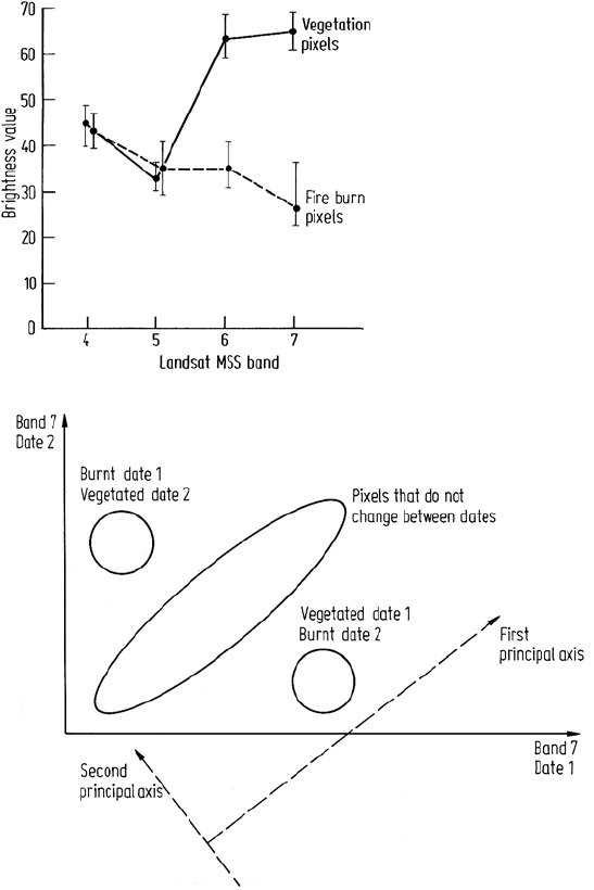
Figure 11.5 shows the spectral reflectance data of healthy vegetation and vegetation
damaged by fire, typical of that in the image data to be used below. As expected,
11.7 Case Study 2: Multitemporal Monitoring of Bush Fires 315
Fig. 11.5. Typical spectral reflectance data
of healthy vegetation pixels and fire dam-
aged vegetation pixels. These have been
derived from the actual image data used
below. Reproduced from Remote Sensing
of Environment, Vol. 16, 1984
Fig. 11.6. Hypothetical illustration of a 2 dimensional 2 date Landsat MSS band 7 space,
showing the dispersion of pixels associated with constant cover types and those that change
between dates
the major effect is in the infrared region, corresponding to band 7 of the Landsat
(1–3) MSS. To illustrate the value of principal components in highlighting changes
associated with fire events suppose we consider just band 7 data from two dates.
One date is prior to a fire and the other afterwards. We can construct a two date
scatter diagram as shown in Fig. 11.6. Pixels that correspond to cover types that
remain essentially constant between dates cluster about an elongated area as shown,
316 11 Image Classification Methodologies
representing water, vegetation and soils. Cover types that change between dates show
as major departures from that general trend. For example pixels that were vegetated in
the first date and burnt in the second lead to the off-diagonal cluster shown. Similarly
pixels that appeared burnt in the first date and revegetated in the second appear as an
off-diagonal cluster in the opposite direction.
Principal components analysis will lead to the axes shown in Fig. 11.6. As seen the
band 7 variations associated with the localised changes project into both component
axes. However the effect is masked in the first component by the large range of
brightnesses associated with the near-constant cover types. By comparison the change
effect in the second component will dominate since the constant cover types will map
to a small range of brightness in the second principal component.
The same general situation occurs when all available bands of image data are
used. However several of the higher order components will reflect local change
information.
11.7.3
The Study Area
In December 1979 the State of New South Wales in Australia experienced a number
of major bushfires. While the majority of these were in mountain ranges to the west
and northwest of the capital, Sydney, one particularly threatening fire occurred in
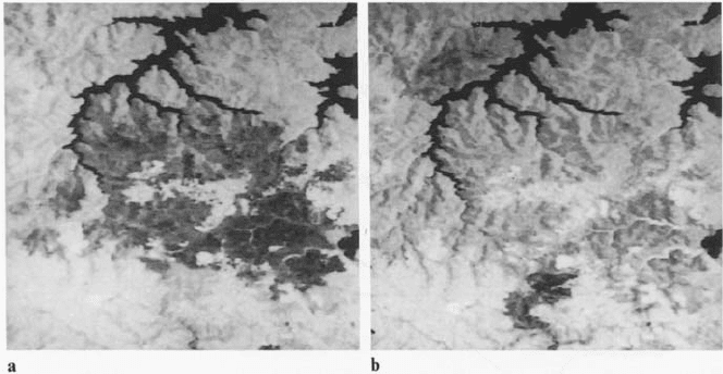
Sydney’s northern suburbs. Figure 11.7a shows a portion of a Landsat MSS image
in this vicinity acquired on 29 December 1979. The area of bushland damaged by
fire appears dark. The same region almost one year later (14 December 1980) is
shown in Fig. 11.7b. The 1979 fire scar is diminished owing to partial vegetation
recovery. However, two new fire burns are evident, as indicated, resulting from fires
in the intervening period. The pair of images together therefore allow examination
of vegetation to fire burn change and fire burn to revegetation.
11.7.4
Registration
Areas about two to three times larger than those shown in Fig. 11.7 were registered
utilizing approximately 20 control points spaced near the scene circumference with a
few scattered over the scene centre. The actual positions of some control points used
are shown in Fig. 2.17a by comparison to the study area. Cubic polynomial mapping
of the 1980 image to the 1979 image was performed. Resampling was based upon
cubic convolution interpolation since the primary intention of the project was to
examine principal components images by photointerpretation. The resulting average
standard errors for the prediction of control points in the master image from those in
the slave were less than 1/4 pixel spacing in both row and column.
11.7 Case Study 2: Multitemporal Monitoring of Bush Fires 317
Fig. 11.7. a Portion of the Landsat MSS band 7 data acquired over Sydney on 29 December
1979. The dark region in the centre is an area burnt out by a fire several days earlier. b The
Landsat MSS band 7 of the region in a but acquired almost 1 year later, on 14 December 1980.
The fire burn is revegetating as evidenced by the developing light regions. Two new fire burns
have occured. These show as dark regions on the north-western and southern regions of the
image segment
11.7.5
Principal Components Transformation
The registered subscenes were added to form an 8-dimensional multitemporal image
data set (in the order 1979 band 4, 1979 band 5 ... , 1980 band 4, 1980 band 5 ... ),
from which the set of principal components was generated. Automatic polarization
(inversion of brightnesses) and scaling options were chosen in the transformation
process as these gave component images with better visual dynamic range and it
was felt that they would not prejudice subsequent interpretation at the level of dis-
crimination envisaged (into major cover types and change classes but not into fine
subdivision of vegetation species, etc.).
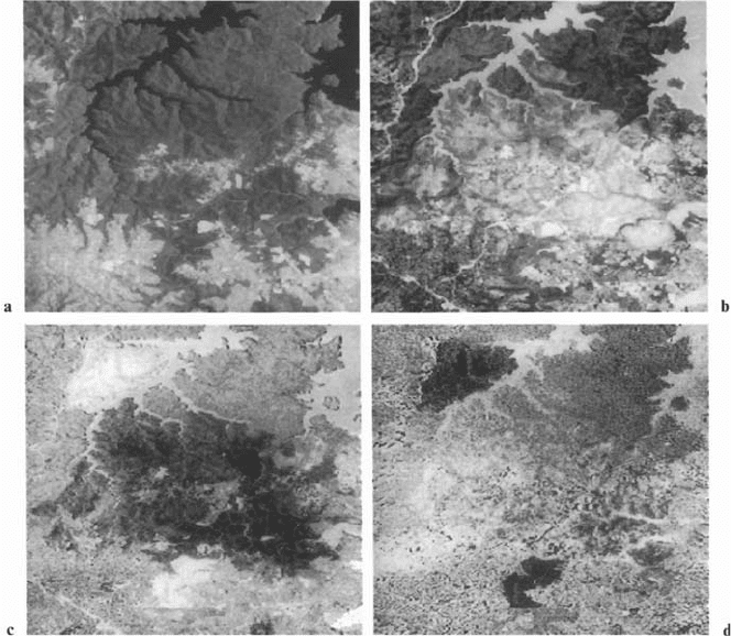
The first four of the eight principal component images are shown in Fig. 11.8.
The remainder do not display any features of significance to the study. The first
component is tantamount to a total brightness image, whereas the later components
highlight changes. It is the second, third and fourth components that are most striking
in relation to the fire features of interest. Pixels that have essentially the same cover
type in both dates e.g., vegetation and vegetation, fire burn and fire burn, show as
midgrey in the second, third and fourth components. Those that have changed, either
as vegetation to fire burn or as fire burn to vegetation show as darker or brighter
than midgrey, depending upon the component. These effects are easily verified by
substituting typical spectral reflectance characteristics into the equations that gen-
erate the components. Each component is a linear combination of the original eight
bands of data, where the weighting coefficients are the components of the corre-
318 11 Image Classification Methodologies
Fig. 11.8. The first four principal components of the 8-dimensional data set formed by con-
catenating the four Landsat MSS bands of the region of interest from each date. Components
are numbered as a PC 1; b PC 2; c PC 3; d PC 4. Components 3 and 4 particularly highlight
the fire-related events. Reproduced from Remote Sensing of Environment, Vol. 16, 1984
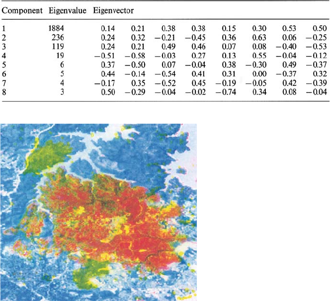
sponding eigenvector of the 8 ×8 covariance matrix. These eigenvectors along with
their associated eigenvalues (which are the variances of the components) are shown
in Table 11.4. In interpreting the fourth component it is necessary to account for a
polarization inversion introduced in generating the set of principal components.
The second principal component image expresses the 1979 fire burn as lighter
than the average image tone, while the third principal component highlights the two
fire burns. The 1979 burn region shows as darker than average whereas that for 1980
shows as slightly lighter than average. In the fourth component the 1980 fire burn
shows as darker than average with the 1979 scar not evident. What can be seen,
however, is revegetation in 1980 from the 1979 fire. This shows as lighter regions. A
particular example is revegetation in two stream beds on the right-hand side of the
image a little over halfway down.
A colour-composite image formed by displaying the second principal component
as red, the third as green, and the fourth as blue is shown in Fig. 11.9. This shows
the area that was vegetated in 1979 but burned in 1980 as lime green; the regions
11.7 Case Study 2: Multitemporal Monitoring of Bush Fires 319
Table 11.4. Eigenvalues (variances) and eigenvectors of the 8-dimensional, original image
data covariance matrix. The eigenvectors are the component weighting coefficients
Fig. 11.9. Colour composite multitemporal image formed by displaying the second principal
component as red, the third principal component as green and the fourth principal component
as blue
from the 1979 burn that remain without vegetation or have only a light vegetation
cover in 1980 show as bright red; revegetated regions in 1980 from the 1979 fire
display as bright blue/purple whereas the vegetated, urban, and water backgrounds
that remained essentially unchanged between dates show as dark green/grey.
11.7.6
Classification of Principal Components Imagery
Because of the change enhancement offered in the principal components it should
be possible to produce a change class thematic map by classification.
An initial unsupervised classification of the first four principal components pro-
duced substantial confusion between water/land and fire burn/vegetation. Owing to
the nature of the first component, this is to be expected. A second test using com-
320 11 Image Classification Methodologies
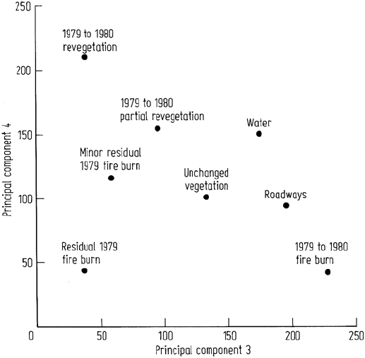
Fig. 11.10. Bispectral plot used for developing spectral classes in the classification of the
third and fourth principal components into major fire-related themes. Reproduced from Remote
Sensing of Environment, Vol. 16, 1984
ponents 2, 3, and 4 was acceptable, although some of the richly revegetated regions
were unclassified. Consequently, it was decided to use just components 3 and 4 in
the classification since a visual inspection indicates that they contain most of the
class/change class information required.
The six major cover types were roadways, water, 1979 to 1980 fire burn, 1979
to 1980 revegetation, unchanged vegetation, and residual 1979 fire burn. Unchanged
urban regions were not considered since resolution of these from other unchanged
classes such as vegetation and water was not required. Maximum likelihood signa-
tures for the six selected classes were generated. This left a significant proportion
of what could be called “partial revegetation (1979 to 1980)” and “minor residual
1979 fire burn” unclassified. This situation was rectified by adding these two further
classes as shown in the bispectral plot of Fig. 11.10.
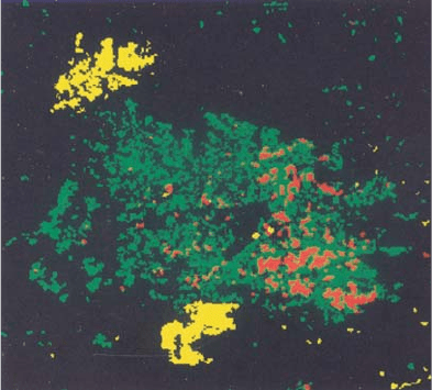
The classification map of Fig. 11.11 was obtained using the eight subclasses,
along with a likelihood threshold so chosen to avoid classification of regions for
which signatures were not developed (such as urban). In the map only three major
change classes are displayed, these being minor and major vegetation regeneration
from 1979 to 1980 (the decision was made by inspection of the original standard
colour composite images), the 1980 fire burn, and the residual bare effect from the
1979 fire. The latter is not strictly a change class for the pair of images considered
11.8 Hierarchical Classification 321
Fig. 11.11. Thematic map generated by classification of the third and fourth principal com-
ponents. Only three classes are shown. These are vegetation regeneration (green), the 1980
fire burn (yellow) and the residual bare effect from the 1979 fire (red)
but, nevertheless, was generated easily and is a significant class in the context of the
study of fire damage and vegetation recovery. Notable in this classification is that
there appears to be no confusion between burn and revegetating pixels, and water
edge regions. The reason for this is that the water edge pixels are approximately
constant between dates (to the extent that tides are constant) and thus are correlated.
They will map therefore to the midgrey constant background region of the higher
order principal components, whereas the fire burn pixels (with which they can be
confused) are vegetated in one date and burned in another and thus map to a quite
different range of brightness in transformed imagery. Experience with single scene
classification often shows water edge and fire burn confusion.
11.8
Hierarchical Classification
11.8.1
The Decision Tree Classifier
The classifiers treated in above have all been single stage in that only one decision
is made about a pixel, as a result of which it is labelled as belonging to one of the
available classes or is left unclassified. Multistage classification techniques are also
possible in which a series of decisions is taken in order to determine the correct label
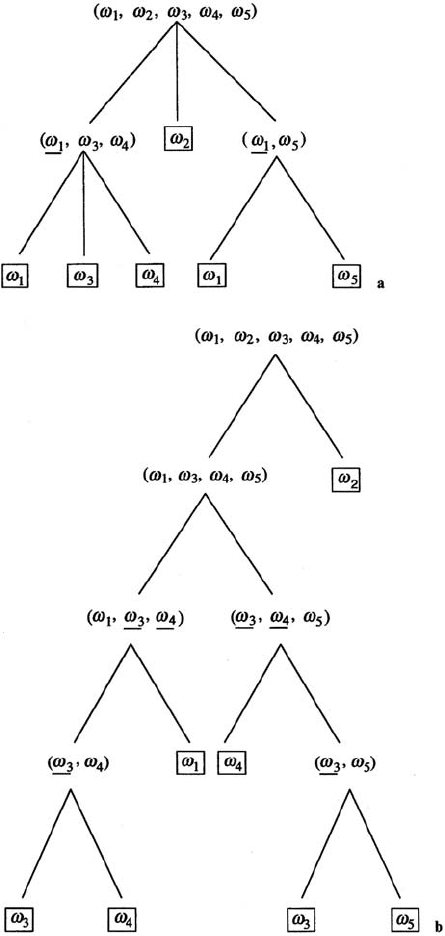
for a pixel. Examples of such an approach are shown in Figs. 8.17 and 8.18. The
more common multistage classifiers are called decision trees, examples of which are
shown in Fig. 11.12. They consist of a number of connected classifiers (or decision
322 11 Image Classification Methodologies
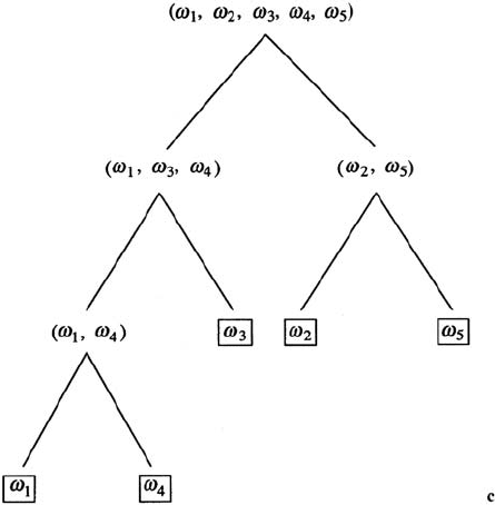
Fig. 11.12. a A general decision tree. b A binary decision tree with overlapping classes.
c A binary tree without overlapping classes – underlines indicate class overlaps
11.8 Hierarchical Classification 323
Fig. 11.12c.
nodes) none of which is expected to perform the complete segmentation of the image
data set. Instead, each component classifier only performs part of the task, as noted
in the figure. Perhaps the simplest type is the binary tree in which each component
classifier, or node, is expected to perform a segmentation of the data into only one
of two possible classes, or groups of classes.
The advantages of using a multistage or tree approach to classification include
that different data sources, different sets of features, and even different algorithms
can be used at each decision stage. Minimising the number of features to use in a
decision is significant for reducing processing time and for improving the accurcy
of small class training.
11.8.2
Decision Tree Design
Frequently, decision tree strategies can be designed manually, particularly when
they are required to perform quite specific labelling tasks (Swain and Hauska, 1977).
However, as with single stage classifier and neural network training it would be of
value to have automated design procedures available.
There are three tasks in the design of a decision tree: finding the optimal structure
for the tree, choosing the optimal subset of features at each node, and selecting the
decision rule to use at each node. An optimal or suboptimal tree structure may aim
for minimum error rate, a minimum number of nodes, or a minimum path length in
deciding how to split classes at each node of the tree; consideration must be given also
