Raabe J. Hydro power - the design, use, and function of hydromechanical, hydraulic, and electrical еquipment
Подождите немного. Документ загружается.


i
internal; instant21:eous; due
to
Birnbaum point
1
loss.
M
mean value; channel centre line.
m
mixed; meridional.
min
minimum.
max
maximum.
,
nozzle.
nominal value.
OP
out
r
res
ra
R
best point (bep).
outlet.
point
P
on contour; pumping; pressure face; power house; permanent.
pipe; passive cascade.
plate.
volumetric loss (leakage).
rated; radial; roughness.
resulting.
runaway.
rotor; residual cascade.
rotor blade; suction face; saturation point.
draft tube; streamwise direction; longitudinal.
stagnation point.
shaft.
circumferential.
loss, vapour.
windage; wheel.
in
x,
y,
:-direction, respectively.
Other
symbols
n
vector in
n
direction.
no
unit vector.
-
c
time-averaged velocity
c.
C'
velocity fluctuation.
h
'
nondimensional value of
h.
d
time derivative of
R.
A
deviation; Laplace operator.
L

1.
The origin
of
hydro power, its potential and its use
in
a
world wide context
1.1.
Introduction
The main sources of hydro power are the large river systems of the world with their vast
catchment areas.
A
survey of the characteristic features of some river systems shows that
the usable potential increases more with the catchment area than with the mean altitude
of the system. The usable potential is usually greater in the downstream areas than in
the
upstream ones. In general the potential does not only depend on such obvious figures as
the total river length or the discharge at the river mouth.
The topography of the continents together with the climate and
the rainfall rate may
favour the damming of a river even of
low gradient provided the valley has a sufficient
depth. This and the collection of water creates head and discharge as the basic require-
ments of hydro power. The theoretical potential
of
the world can be predicted from
hydrographs, precipitation and the gradient of the river. It is always related to the usable
potential. This depends on the theoretical potential and
rcsults from the technical possi-
bilities available, from the feasibility of electric power
transn~ission over a lor?€ distance
and from the power demand in the neighbourhood of a certain scheme. Any development
requires a usable potential, a certain demand for power and a reasonable electricity rate
due to hydro power. Therefore the usable potential has to be considered in the context
of the total power production at least of the total electricity production in the area of a
certain site. For these reasons the harnessable potential of the river power does not only
change with the system of rivers and their topography, but differs also from one
cou12try
to another depending on their economies. When compared with other sources of primary
energy it has its merits,
e.g., its regeneration and availability for nearly nothing
in
addition
to the absence of
polliltion. It can be generated by run-of-river, storage, diversion,
depression and tidal power plants. Tt may easily be stored by damming and pumping to
cover peak load economically and with flexibility.
1.2.
Water from rivers, its causes and features
1.2.1.
The
rivers
1.2.1
.I.
Large
sources
of
water
power
Mountain regions are more gifted with water power than the plains. They usually
combine the advantages of water courses and inclined surfaces and are therefore impor-
tant
as prerequisites of water power. I-iowever because of their larger surface area the
plains
1113~
surpass mountain regions
in
their energy potential. Hence the biggest supplies
of "tvliitc c;,;~l"
;LX
017t;linccI frol~i tjic !:lrsc i.ivcrs
of
thc plairls ;l!id nor from nlountain
torrcrit.;. c.2.. (tic c;rtclii;ic~it
;IXI
of tlic rli!cr I'a~-;i~~i'i
:it
lt;iii>ii
:it
its
exit
fro111 lIr;~/.il
is
fot~r
till?cs tlic
S~II.~;ICC
;II.C;I
01'
~VCSL
Cicrmany.
scc
[I.
I].
1.2.1.2.
Cl1;11-actcristics
3rd
cl;~ssific;ltion
of
well-known
ri~crs
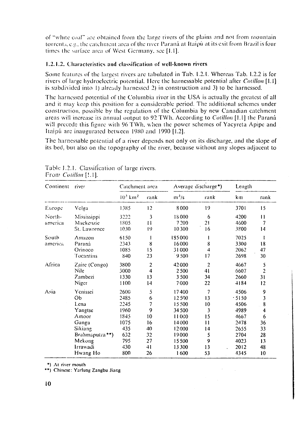
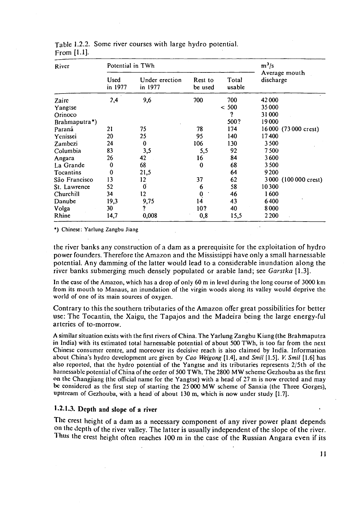
Sorne fcat~~rcs of thc 1:ir~cs: rrvcrs arc tabi~latcd in
Tab.
1.3.1.
Whcrcas 'Tab. 1.2.2 is for
rivers of
I;trsc Itytlroelectric potcntial. ilcl-e the 11:irncssnble potenlial after
Colillort
(1.11
is
s:rbJi\iclcd into
I)
alrc;,rly lii~r~lc~~~~i
2)
in
construction and
3)
to
be
harnessed.
Thc hnrncsscd potcntial
of
tlic Co1umbi;i rivcr in the USA
is
actually thc grcatcst of all
a~?d
I!
nxiy
keep
rh~\ position for
;I
cun,\idcr.riblc period. The additional schcrnes under
construc.tiol~. po\siblc
by
thc
regulation
of
ti~c Colt~lnbia by ncw Canadian catchment
arcris
~~11'1
rlm-c,lx irs annual oiltput to
93
TWti. Acco~ding to
Cotillori
[I.
I]
thc Paranli
RI!~
prccedc thrs figurc nrth
96
TlVh.
ui~en tlic power schemes of Yncyreta Aplpe and
Itaipir arc innu~urritcd bctnccn
I9XO
ancl
1990
[1.2].
Thc harnessablc poic~~tial of
a
river dcpcnds not only
on
its discharge,
and
the slope of
its bed,
bur also
on
rlic topography of tlie rrver, because without any slopes adjacc~~t to
Tablt.:
1.2.1. ~iassifica tioil of large rivers.
Prow
Cotillor7
[!.I].
Continent river
Cx~chrncnt
a
re:\ Averngc discharge*) Ler~gtli
10"1n~
i-ank
~n'/s
I.;I
n
k
k
111
nln
k
Korth-
XIississ~ppi
:rrnc;ic;t
bl:~ckcl~zie
St.
Lau
rencc
South
A!II;IZOII
amcrii:;;
Parani
Orinoco
I'ocanlir~s
cifricit
Zaire (Cori_eo)
Nile
Zambezi
Niger
42
GOO
2
500
3
500
7
000
Asia
Ycnissei
Ob
Lena
Yangtse
Atnoor
G
a
ng3
Si
kiang
Bra:lmlipuii.n"*)
Mekong
lrra\vacl~
H\vacg I30
1
7
400
I
2
500
15
500
34
500
I
1
OUO
14
000
1
2
I100
1
9
000
15 500
13
300
1
600
*)
At
river
mouth
**)
Chiricse
:
Yzrlung
Zangbu
Jiscg
Table
1.2.2.
Some river courses with large hydro potential.
From
[1.1].
-
River Pote~~tial in TWh m3/s
Average mouth
Used Under erection Rest to Total discharge
in
1977
in
1977
be used usable
--
Zaire
Yangtse
Orinoco
Rrahmaputra
*)
Paran6
Y enissei
Zambezi
Columbia
Angara
La Grande
Tocant ins
S'5o Francisco
St. Lawrence
Churchill
Danube
Volga
Rhine
42 000
35 000
3
1
000
19000
16
000 (73 000
crest)
17 400
3
500
7 500
3 600
3
500
3
200
3 000
(1
00 000
crest)
10
300
1
600
6
400
8
000
2200
.
*)
Chinese:
Yarlung
Zangbu
Jiang
the river banks any construction of
a
dam as a prerequisite for the exploitation of hydro
power founders. Therefore the Amazon and the Mississippi have only a small harnessable
potential. Any damming of the latter would lead to a considerable inundation along the
river banks submerging much densely populated
cjr arable land; see
Garstka
f1.31.
In the case of the Amazon, which has a drop of only
60
m in level during the long course of
3000
km
from its mouth to Manaus, an inundation of the virgin woods aiong its valley would deprive the
world of one of its main sources of oxygen.
Contrary to this the southern tributaries of the Amazon offer great possibilities for better
use: The
Tocantin, the Xaigu, the Tapajos and the Madeira being the large energy-ful
arteries of to-morrow.
A
similar situation exists with the first rivers of China. The Yarlung Zangbu Kiang (the Brahmaputra
in India) with its estimated total harnessable potential of about
500
TWh, is too far from the next
Chinese consumer centre, and moreover its decisive reach is also claimed by India. Information
about.China's hydro development are given by
Cao
Weigong
[1.4],
and
Smil
[1.5].
V
Smil
[1.6]
has
also reported, that the hydro potential of the Yangtse and its tributaries represents
2/5th of the
hsrnessable potential of China of the order of
500
TWh. The 2800
M
W scheme Gezhouba
as
the first
on the
Changjiang (thc oficial name for the Yangtse) with a head of
27
m
is
now erected and may
bc
considered as the first step of starting the
25000
MW scheme of Sanxia (the Three Gorges),
upstream of Gezhouba, with a head of about
130
m,
which is now under study
11.71.
1.2.1.3.
Depth
and
slope of
a
river
The
crest height of a dam as a necessary component
of
any river power plant depends
011
lhc
depth
of
the river valley. The latter
is
usually independent of the slope
of
the river.
'lhs
the crest height often reaches
100
m in the case of the Russian Angara even if its
slope of
1
:
5000
is about h;tlf of that of thc Columbia, which rcaches this height only once
at
<;ranti Coulce. Also thc Volgn occ:~siorlally provides hca~ls
df
I
I
to
24
m, the same as
the'i'ennrssce has. ever, though the slopc
or
the latter is thrcc times lar_~cr. I'hc sinall slope
of the
Volg;~ csplnins thc Lnormous length of its >torage basins which reaches
530
km in
Volgograd (formerly
Stalingrad). The
surface
area being 3100 km2. Sce
Grrhin
[l.S],
Borovoi
[I
.9],
and
Cotillorl
[1.1].
If the rivcr bed is only slightly cut in, dikes of small height are necessary for distances of
tens and sornetimcs
hundrcds of km. Thus on the Argentine Parana, to exploit two
16
l'Wh stations,
245
krn of dikes are needed in a reach
of
600
km, hsving a mean slope
of
0,OOG
%.
But often the Jeep cut
of
the rivcr bed dispenses with the need of a dike. Thus
on the
Dnjepr
a
dike was built only for
50
km out of 185
km
on the left river bank near
Kiev, see
[1.1!.
Contrary to this. dammirlg dikes are needcd for the French-German Rhine and the
Danube in the
neighbourhood of Vienna; see
Lejoulon
[1.10],
Gotz
[1.11], and
Cotillon
[l-11.
1.2.1.4.
High
head
and
large
discharge
These favourable circumstances exist in general where the river leaves the large plane of
its main catchment area through a series
of rapids, usually located in
a
strongly sloping
gorge.
l'he Churchill Falls on the Churchill river in Labrador, Itaipli on the Parana in
the
south of Brazil, the Inga Rapids on the Zaire (formerly Congo) and the Victor2 Falls
on the
Zambezi
are some of the most characteristic examples [I. 11.
Sometimes the cut
ir!
of the river bed with
a
strong slope may be long and the level drop
large. In this
case many power plants ir, cascades are needed. 'This holds true for !he rivers
hianicouagan, Aux Ouiardes and
La
Grande as tributatires of the St. Lawrence and the
Hudson Bay respeciively.
A
plateau may have steps, the
accompanying
river then has
some natural falls,
sometimes
at large distance from each other. This is th,: case of thz
St. Lawrence in Canada (e.g., Niagara Falls).
The exceptional aspects of some river sites
resuit from considerations .of topography ar:d
climate.
1.2.2.
Topography
1.2.2.
i.
The
elcrne~~ts
of
the
continents
The continents are formed by three essential elements: The plateaus, the ranges and the
basins. The plateaus are the platforms, which originated from the formation
of
planes due
to erosion of the mountain ranges of the Primary Earth Period. They cover the largest
portion of the continental surface.
The ranges are nearly all
f~rmed in the Alpine folding period, e.g., the Alps, the Himalaya
and the Andes. As
a
whole they occupy the smallest portion of the continent.
The basins originate from sedimentation of the material eroded from ranges and plateaus.
They correspond to the low regions
of
the continent, progressivzly lowered by the rising
weight of marine or river sedimentation. Due to their different origin their age may be
very distinct and even of the Primary
P-eriod of the earth like the Toungouza in the
North-East of Siberia. They cover the second largest part of the surface
area of continents,
less than the plateaus and greater than the ranges. Examples may be the North American
belt of the Prairies. the Western Amazon basin and the Rio
Plata basin
of
Brazil and
Paraguay.

1.2.2.2.
Topography
and
water
circulation
The topography creates slopes, rapids and falls and collects the water in river beds. This
is possible because of the earth's surface water [1.12], the sun's radiation, and the resulting
evaporation of water, which rises in a heavier atmosphere (the troposphere) up
to
the
outer edge of the latter and is transported by winds. When this water drops down from
~Iouds only a very small portion of its original potential energy relative to the ocean level
~ernains for the potential of the rivers.
A
large portion seeps into the ground, and another
evaporates again.
The downstream gravity component of a river with a sloping bed is the origin of the
kinetic energy of a stream. This is finally converted into heat by dissipation. The local
water circulation, investigated in
[1.13] may be considered as a part of the global one
mentioned above. The latter is also the base of our terrestrial life
[1.14].
1.2.2.3.
Topography as the origin of falls and water collection
-
The falls: The steps in the slopes of a river bed creating falls or steep slopes of the river
bed, with rapids, are always linked to rocky elements sometimes in the form of
a
chain.
They may result from an elevated plateau being adjacent to the lower basin of sedimen-
tary or marine origin. The connection of both by the river is made usually by a drop in
level ranging from 1 to 10% or also by a fall if the boundary of the plateau is sufficiently
resistant or perhaps by a series of subsequent falls. This passage from the plateau to the
basin is illustrated by the
Paran5 in its southern part leaving the Brazilian plateau at the
falls of Sete Quedas 1700 km from the river mouth
(1.11.
The transition from the plateau to the ocean by an inclined profile of the river bed, is
given in the cases of the Canadian rivers
Churchill (Labrador), Aux Outardes, Manicoua-
gan and
La
Grande [1.1].
If the river is barred by the plateau it is diverted there in se\~eral arms or cuts towards
the ocean. The Zaire downstream of Kinshaha-Brazzaville is an example of the diversion
type and the
Dnjepr of the cutting type.
When the plateau emerges from a sedimentary ground in the form of a barrier this
determines a break of the slope. The Yenissei at Krasnoyarsk illustrates this. The same
occurs, when a mountain range crosses the location of a basin. This is the case at the Iron
Gate, where the Danube crosses a spur of the Carpathians.
The short-circuiting of a river bend may enlarge considerably the slope in the diversion thus created
(Diversion power plant).
The
most famous cut of a river bend, only an idea to date, is located in
China at Yarlung
Zangbu (Brahmaputra): The length of the short-circuited reach bctween Timpa
and Yortong
is
of the order of 200
km,
the level drop 2200
m,
the time-averazed discharge is
2000
m3/s, the power produced could attain
240
TWh
annually.
The
distance between
Timpa
and
Yortong
is
40
km,
but only an underground diversion of
16
km
is
needed, see
Cotillon
[1.1].
-
The
collection of water: According to
Cotillon
(1.11 river systems are partly elementary
and partly
of
an hierarchic order. In the first case we have rivers following the line of the
greatest slope. The rivers of the Baie James (La Grande), also
the Manicouagan and Xux
Outardes are good examples.
Thc
other limiting system is that of a network around one final collector. I-Iere the
ciitchment area, feeding the main river assures the cor~centration of
the
discharge in
various ways. Because of their small resistance to crossing, the sedimentary basins
rcsult
into
this
concentration (Zaire, Yenissei). But this may occur also above
a
plateau (Parana)
or
;IS
in thc C,l?inz rilngcs. whcre tl~ey
ii:tvc
been formctl
by
ci~ptrrre oftcr~ tl~lc
to
regressive
erosion,
scc
Col
illorr
[
1.1
1.
Trernc:iclous regions tniiy be drained
by
one single collector. The largc Sibcrii~n rivers
(Yet~issci, Ob, Len;t) havc ciltcht~le~~t ;lrc;rs, each of which is ten ti~iics that of \Vest
C;ern~;lny
and
in the cxc of Zaire (Congo) this figure would be
13.
ancl
22
titlies for the
Amazon. The
catchmcnt area is not litiiitcd always by nioantainous ranges forming the
horizon. Sometimes
especially
in Jurrnsic ground subterranean streams connect adjacent
catchment
areas, e.g. that of the upper Danube with tkat
of
tllc Khinc by the Ache.
1.2.3.
Climate
The
clirnate also determines the nature
af
a hydro power site. Outside the equatorial zone
with its high
rr:infall
and
its arid bound:try zones the depth of annual rainfall gro\xls as
the ocean is approached. On the other hand rising continental character reduces the
precipitation rate.
Rivers
of
large discharge may have on the one side a large catchment area together with
a
sn~ail precipitation or vice versa. Thus the Siberian Angr~ra and La Griinde (Hudson
Bag) havc the same
mean dischargc at their river mouth, but thc precipitation rate of the
catchment
are2 is five times largzr on the
La
Grande than
on
the Angara
[1.15].
Exceptionally large discharges like those of the Aniazon and the Zaire (Congo) result
from
a
combination of an immense catchment area and
n
high equatorial precipiiation
rate. The hydro electric
Ing:i
site on the Zaire is unique, because the topography and the
ciinmtz are cumulative in contributing ail the possible factors for water power produc-
tiun: Lclrge dischargc froni equatori~l rainfall rate and a large catchrncnt area near the
river mouth and rapids
and hence high available head there, where the river possesses its
final flow rate,
[1.16].
1.3.
The
potential
and
its
distribution
1.3.1.
Theoretical,
harnessable,
harnessed
potcntinl
The potential
of
a certin river system is defined by the annu:~l
work
that the surface
water of the system produces in the
average year. Table 1.3.1 shows the distribution of
the theoretical and harnessable potential and
installable capacity over the different
re@ioris
of
the world. Tab1.e
1.3.2
shows the same for the mzin producers of
hydro
power,
supplemented also by
the harr~essed potential and the itlstalled capacity
[l.
11.
Thc thcorctical potential
7:
can be ci~lculated from averaged hydrographical records or cstimztes
and level drop measurements along the river course
in
the iollowing
way.
For every river the
dist!-ibution of
the
time-averagcd dischargc
Q
and the level drop is taken along its course from the
source to the mouth or confluence point. From this is known for
a
section
i
of
!he
rivcr between the
confluences
of
two sub.cequent tributaries
the
timc-averaged discharge
Q;.
The drop
in
level
Ah,
of
this
section
is
also known. This
then
yiclds the theoretical powor of
ths
scction considered
de
=
g
Alli
q
Q,.
Sumrning
up
this fisure
over
the whole Icng!h of all
the
rivers
in
the area considered,
the
thsorcticnl potential
7-
is obtained
as
annua! work in a mean year
(p
being the drilsity of water)
A
more
simple
estimate of
T
rcsults from
the
relation:
T
=
mean drop
in
lcvcl
in
the c:ltchmcnt
area
s
catchment arca
x
precipitation rate per
unit
area and year
x
9,8313600.

Table 1.3.1. Distribution of Hydro Potential over the world.
Aftcr
Cotilloi~
[I.
11.
-
Zone
Surface
Theoretical
Usable
Installable Load factor
area potential
T
potential
H
capacity
P
(cp)
in
lob
km2 in TWh
in TWh in
GW
H/(8760
P)
Europe
without USSR
4,9 3 400 700 215 0;37
-
USSR
22
4
000 1100 269 0,465
USA,
Canada,
Greenland
2
1
6
100 1300 200 0,740
Japan, China
10
9
000 1450 380 0,435
Middle and
South America
20,5
5
400 1850
.
328 0,642
Africa
30 6 300 2000 437 0,52
Asia (without
Japan, China,
Siberia)
2
1
?
1200 309 0,443
Oceania and
Australia
8,5
1
500
200 38 0,60
Antarctis
14 200
?
?
-
Total
153 36 000
9800 2266
0,385
The error in using formulas like this results from the fact that usually the relevant mean drop in level
lies far below the mean value given by the highest difference in altitude of the mountains of this
aica.
Thus in Europe mountainous areas with an altitude range of
2500
m
possess one third of their area
at altitudes below one tenth
oi
2500
m. Therefore the simplified formula !eads usuaily
to
an over
estimation of the theoretical potential.
The harnessable potential
H
depends on the one hand on the theoretical potential and,
on the other hand it depends on the power demand, on
the technical tools for river power
development, on the distance of the site envisaged from the next consumer and hence also
on the state
of
the art of power transmission. Therefore the harnessable potential is a
figure varying with time.
The same holds on a larger scale for the potential harnessed. This figure naturally
increases continuously as long as it falls short of the harnessable potential
H.
Table 1.3.1 shows, that for 1974, for example, the harnessable potential of 9800 TWh is
27%
of
the theoretical potential of
36000
TWh (1.11. This comes close
to
a recent
estimate of 44
000
TWh [1.17], and falls short of an earlier estimate of
Slebinger
[1.18] and
incltides also Greenland, the theoretical potential of which is deemed to be
100
TWh.
The
harnessed potential will reach
2200
TWh in 1985 being then 22,4
%
of the harnessa-
blc
potential. In the above, the harnessable potential
is
taken as
9800
TWh
[1.19].
Strictly speaking, the work and not the capacity installed is significant for the development
of
hydro
Po\vcr. Ncv~rtheles~ the installed capacity
is
often used. It depends on the presence of a storage basin,
on
111~
distance of the site from the next consumer centre, and on the peak load demands of the
cll'r'rric
pl.id.
However, naturally the maker of hydromcchanical and electric equipment is more
'tlt''rcs[cll
in
the development of the capacity insta!led.

Table
1.3.2.
Msin
producers of
watcr
powcr
in
1973
11
.I]
and
19SO
[1.77]
Area Thcor. I-Iarncssablc
Iliirncsscd
Illstallcd
Load
Harnessed
?4
of
pot. pot. output
pot. (TWh)
capacity
(G
W)
factor
pot.(TWh) harncsssblr:
-
pot.
(TWh) (TWh)
(GW)
1974
198C
1974 1980 1974 1960 1985 1935
Worid
USA
Canada
USSR
Brazil
Japan
Norway
France
Sweden
China
Italy
lridia
Swit7,erland
Spain
Austria
Yugoslavia
West
Germany
Australia
New
Zealand
Mexico
Argentine
Total
13740 5514 1263.3 1258,O 1500.7 291,7 395,8 '0,450 0,410
1564
392
%
of
world
value
55 56 56 88 8
6
86 6
6
7
1
