NP 100 - Mariners Handbook
Подождите немного. Документ загружается.

110
CHAPTER 5
Home
Contents
Index

CHAPTER 5
111
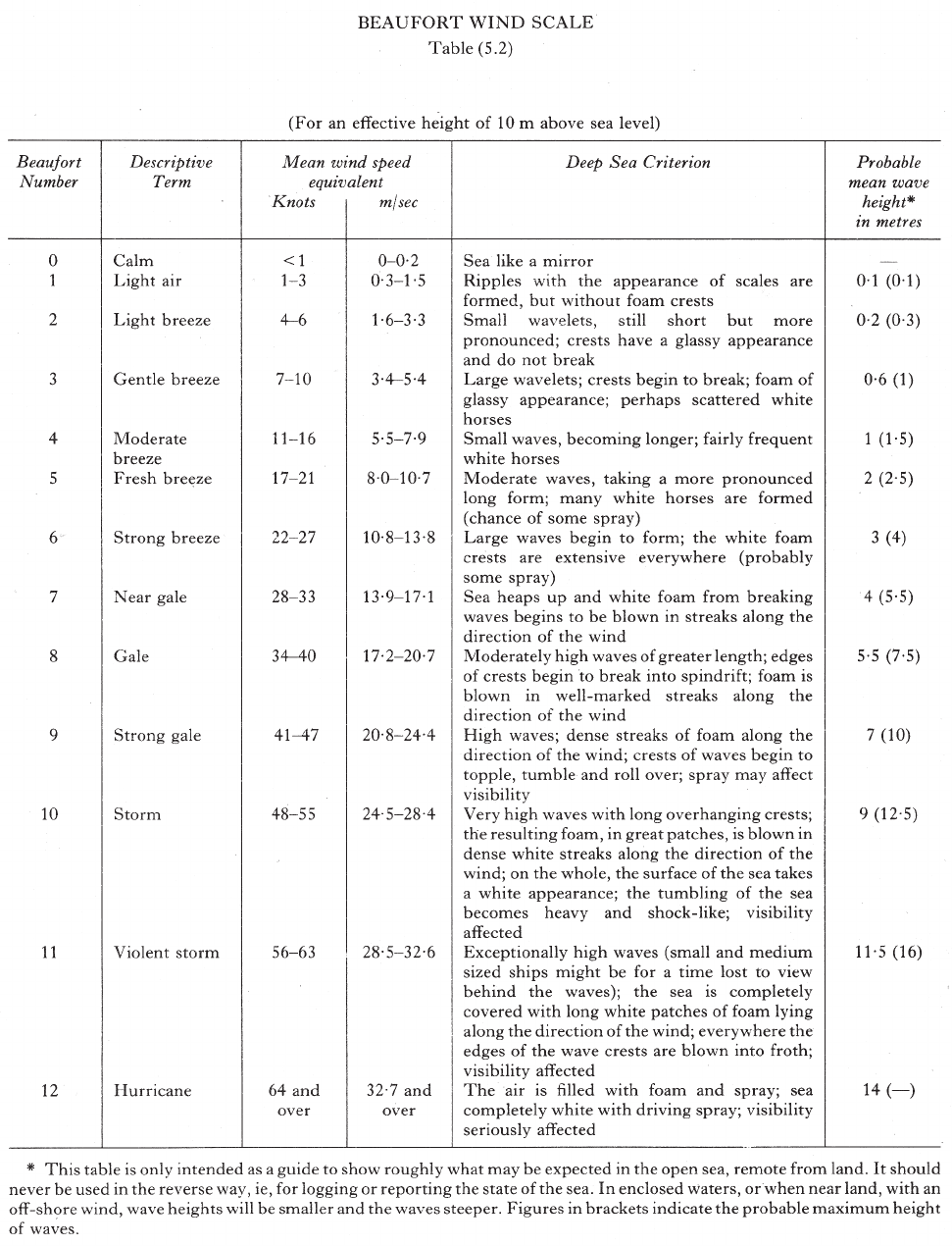
Effects of variation in the sun’s declination
5.4
1 The annual movement of the sun in declination is
followed by corresponding movement of the pressure belts
and associated winds. Movement varies in different
localities but the pressure systems generally migrate about
5°–8° in latitude, lagging some 6 to 8 weeks behind the
sun.
Effects of land and sea distribution
5.5
1 Over large land masses the temperature becomes very
high in summer and low in winter; over the oceans the
variation is comparatively much less. This leads to
relatively high pressure over land in winter and low
pressure in summer; the resulting large seasonal pressure
variations are a dominating feature over continental areas
and produce large scale modifications to winds over
neighbouring oceans. A notable example is the monsoon
wind cycle over the Indian Ocean and W Pacific Ocean
which is caused by the large seasonal pressure oscillation
over Asia.
General climate
Equatorial Trough
5.6
1 A broad belt of shallow low pressure and weak pressure
gradients towards which the Trade Wind air streams of the
N and S hemispheres flow is termed the “Equatorial
Trough” or “Doldrums”. The trough moves N and S
seasonally and in some regions, particularly in the vicinity
of large land masses, its seasonal migration takes it well
outside equatorial latitudes.
2 Within the Equatorial Trough the localities where the
winds from the two hemispheres converge are marked by
lines or zones of massive cumulonimbus cloud and
associated heavy downpours, thunderstorms and squalls,
and are often loosely known as the Intertropical
Convergence Zone (ITCZ). Although a convergence zone
may have some characteristics of a middle latitude cold
front, there is normally little or no air mass contrast across
the boundary nor is there any consistent frontal movement.
A convergence zone is liable to disperse in one locality and
be replaced by a new development some distance away.
3 Thus the weather to be expected in the Doldrums is
variable light or calm winds alternating with squalls and
thundery showers, but on occasion a ship may experience
only fine weather. Conditions are generally worst when the
Trade Winds are strongest.
It is noteworthy that the Equatorial Trough is often the
birthplace of disturbances which, as they move to higher
latitudes, can develop and intensify to become violent
tropical storms.
Trade Winds
5.7
1 Air streams originate in the sub-tropical oceanic
anticyclones of the N and S hemispheres and blow on the
E and equatorial flanks of the anticyclones towards the
Equatorial Trough. General direction is NE in the N
hemisphere; SE in the S hemisphere. They are encountered
and blow with remarkable persistence over all major oceans
of the world, except the N Indian Ocean and the China
Seas where the monsoon winds predominate. The Trade
Wind zones migrate seasonally, and in each hemisphere
extend to about 30°N or 30°S in the respective summers,
25°N or 25°S in winter.
2 Average wind strength is force 3–4, and in each
hemisphere maximum strength is reached in spring; of the
two Trade Wind air streams the SE Trade Winds are
considerably the stronger and the highest average wind
speeds (force 5) are found in the S Indian Ocean. In each
hemisphere the winds tend to weaken on approaching the
Equatorial Trough; on the W flanks of the anticyclones the
winds turn polewards becoming SE in the N hemisphere
and NE in the S hemisphere.
3 Weather in the Trade Wind zones is generally fair and
invigorating with the sky often cloudless or with
well-broken small cumulus clouds. On the E sides of the
oceans visibility is sometimes impaired due to fog and mist
over cold ocean currents or by dust carried offshore by the
wind. Cloud amounts and incidence of rain increase
towards the Equatorial Trough and also on the W sides of
the oceans especially in summer.
Variables
5.8
1 Over the areas covered by the oceanic anticyclones,
between the Trade Winds and the Westerlies farther towards
the poles, there exist zones of light and variable winds
which are known as the Variables; the N area is sometimes
known as the Horse Latitudes (30°N–40°N). The weather in
the zones is generally fair with small amounts of cloud and
rain.
Westerlies
5.9
1 On the polar sides of the oceanic anticyclones lie zones
where the wind direction becomes predominantly W. Unlike
the Trade Winds, these winds known as the Westerlies are
far from permanent. The continual passage of depressions
from W to E across these zones causes the wind to vary
greatly in both direction and strength. Gales are frequent,
especially in winter. The weather changes rapidly and fine
weather is seldom prolonged. Gales are so frequent in the S
hemisphere that the zone, S of 40°S, has been named the
Roaring Forties.
2 In the N hemisphere fog is common in the W parts of
the oceans in this zone in summer.
Polar regions
5.10
1 Lying on the polar side of the Westerlies, the polar
regions are mainly unnavigable on account of ice. The
prevailing wind is generally from an E direction and gales
are common in winter, though less so than in the zones of
the Westerlies. The weather is usually cloudy and fog is
frequent in summer.
Seasonal winds and monsoons
General information
5.11
1 There is a regular cycle of winds over certain ocean
areas, as explained above, which results from seasonal
pressure changes over neighbouring land masses due to
heating and cooling. Most important and best known
examples are the monsoon winds of the N Indian Ocean,
China Seas and Eastern Archipelago.
5.12
1 In the N winter an intense anticyclone develops over the
cold Asian continent and from around October or
November to March a persistent NE Monsoon wind blows
over the N Indian Ocean and South China Sea; over the W
Pacific Ocean the wind is NNE. The winds are generally
moderate to fresh but can reach gale force locally as surges
Home
Contents
Index

CHAPTER 5
112
of cold air move S and particularly where funnelling occurs
(Taiwan Strait, Palk Strait, for example). Weather is
generally cool, fair and with well-broken cloud though the
coasts of S China and Vietnam are frequently affected by
extensive low cloud and drizzle. The NE Monsoon winds
may extend across the equator changing direction to N or
NW to become the N Monsoon off E Africa and the NW
Monsoon of N Australian waters.
5.13
1 In the N summer pressure over Asia falls with lowest
pressure near the W Himalayas. The anticlockwise
circulation gives persistent SW Monsoon winds from May
to September or October over the N Indian Ocean and
South China Sea, and SSW or S winds over the W Pacific
Ocean. Winds are generally fresh to strong and raise
considerable seas. Warm humid air gives much cloud and
rain on windward coasts and islands.
2 Similar regular and persistent winds, also known by the
name of “monsoon” occur in other parts of the world,
although the areas affected are by comparison far more
limited. An example is the Gulf of Guinea where a SW
Monsoon wind blows from June to September.
The seasons of the principal monsoons and their average
strengths are shown in Table 5.13.
Local winds
Land and sea breezes
5.14
1 The regular daily cycle of land and sea breezes is a
well-known feature of tropical and sub-tropical coasts and
large islands. These breezes also occur at times in
temperate latitudes in fine weather in summer though the
effects are rather weaker. The cause of these breezes is the
unequal heating and cooling of the land and sea. By day
the sun rapidly raises the temperature of the land surface
whereas the sea temperature remains virtually constant. Air
in contact with the land expands and rises, and air from the
sea flows in to take its place producing an onshore wind
known as a “sea breeze”. By night the land rapidly loses
heat by radiation and becomes colder than the adjacent sea;
air over the land is chilled and flows out to sea to displace
the warmer air over the sea and produces the offshore wind
known as a “land breeze”.
2 Sea breezes usually set in during the forenoon and reach
maximum strength, about force 4 (occasionally 5 or 6) in
mid-afternoon. They die away around sunset. Land breezes
set in late in the evening and fade shortly after sunrise;
they are usually weaker and less well marked than sea
breezes. The following factors favour development of land
and sea breezes:
3 Clear or partly cloudy skies;
Calm conditions or light variable winds;
Desert or dry barren coast as opposed to forests or
swamps;
High ground near the coast.
In windy conditions the effect of a land or sea breeze
may be to modify the prevailing wind by reinforcing,
opposing or causing a change in direction.
Katabatic winds
5.15
1 When intense radiation, perhaps on clear nights, causes
cooling over sloping ground, the colder denser air will flow
downhill under the influence of gravity producing a breeze
known as a “katabatic” or “downslope” wind.
2 In mountainous regions cold air may accumulate over
high ground; onset of a light wind can displace the cold air
and initiate cascading down a slope to lower ground or into
a valley to give a strong wind which in exceptional cases
can reach gale or storm force.
3 Where mountains rise close inshore such a katabatic
wind can be a serious hazard to small craft or ships at
anchor; onset of the strong offshore wind is often without
warning and may arrive as a sudden severe squall. The
wind may extend several miles offshore.
Among the areas where katabatic winds are common are
Greenland, Norway, N Adriatic Sea, E Black Sea and
Antarctica.
Depressions
Description
5.16
1 A depression (or Low) (Diagram 5.16) appears on a
meteorological chart as a series of isobars roughly circular
or oval in shape around the centre where pressure is
lowest. Depressions are frequent in middle latitudes and
give unsettled weather conditions; they are often, though
not always, accompanied by strong winds. They vary
greatly in size from very small features to very large
circulations over 2000 miles in diameter; central pressure in
extreme cases may be as low as 950 hPa. The extent and
power of a deep and large depression can not only produce
gale force winds but raise very high, persistent and
dangerous seas. In the N hemisphere the wind circulation
around a depression is anticlockwise and slightly inwards
across the isobars towards the low pressure; in the S
hemisphere the circulation is clockwise, see 5.2.
2 Depressions may move in any direction though most
middle latitude systems move in a generally E direction.
There is no normal speed movement. A small developing
and perhaps very attractive depression can travel very
quickly indeed, possibly 30–60 kn; but as a depression
deepens into a large system it usually moves much more
slowly and especially so when decaying and filling.
Fronts
5.17
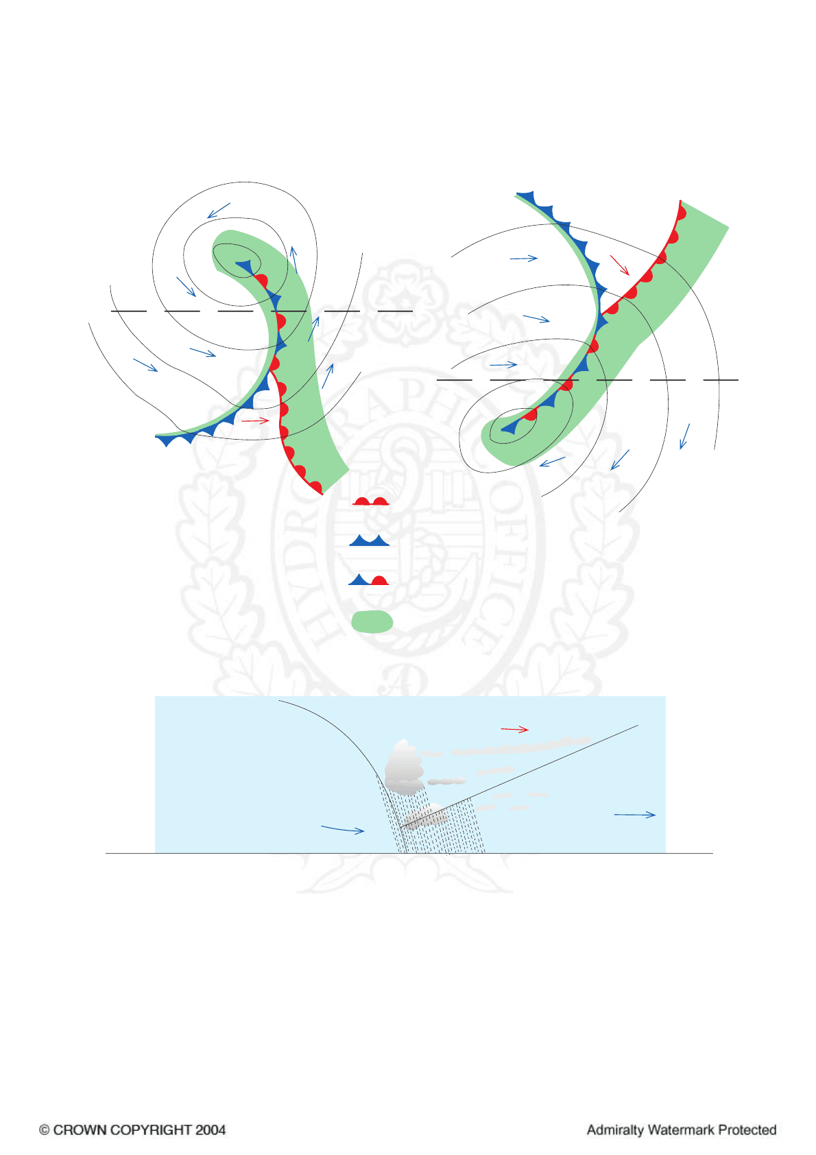
1 Depressions often originate on a front which is the
boundary zone between two contrasting air masses. In
middle latitudes it is usual for air moving from the polar
regions to encounter warm air from the sub-tropics moving
in the opposite direction. At the frontal boundary where the
two meet there is a tendency for small disturbances to
develop on the front where the warm air makes incursions
into the cold air mass and vice versa; the warm air rises
over the cold air.
2 The process is illustrated in Diagram 5.17. A disturbance
appears as a wave on the frontal boundary and travels E
along the front as it increases in magnitude. Pressure falls
in the vicinity of the crest of the wave and a depression
circulation develops.
3 It can be seen that as the leading edge of the frontal
wave, BC, moves E over an observer the air passing him
will change from cool to warmer; this is a warm front.
When the rear flank of the same wave, AB, reaches the
observer the air passing him will change from warm to
cooler; a cold front.
Home
Contents
Index
Area
General
Wind
Direction
South China Sea
NE
SW
NE-N
SW-S
N-NW
SW-SE
N-NW
SW-S-E
NE
SW
NW
SE
SE
SE-E
W-NW
W-NW
South China Sea
Eastern China Sea
Yellow Sea
Japan Sea
Eastern China Sea
Yellow Sea
Japan Sea
North Indian Ocean
Northern Hemisphere
South Hemisphere
North Indian Ocean
Indonesian waters
Indonesian waters
Arafura Sea
Arafura Sea
N and NW Australian Waters
N and NW Australian Waters
Jan Feb Mar
May Jun Jul Aug Sep Oct Nov Dec
Apr
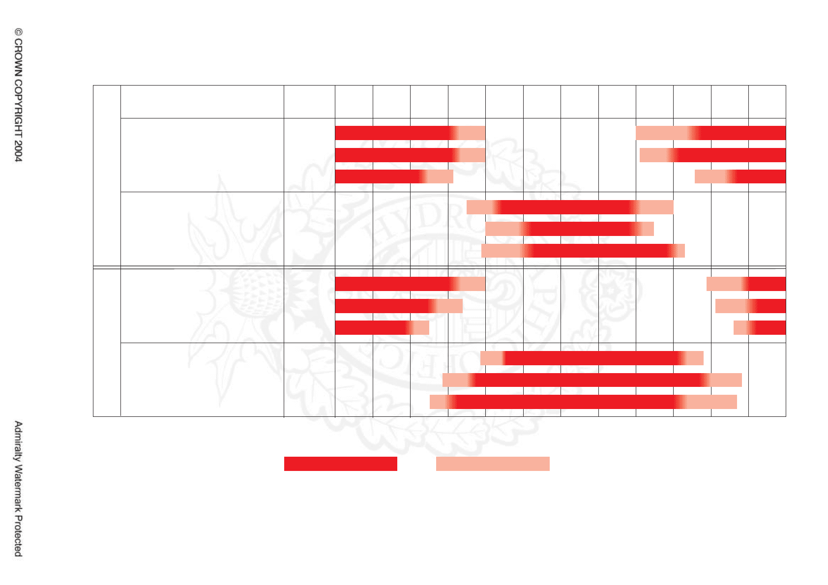
Table showing principal areas affected and months in which tropical storms normally occur
Seasonal Wind/Monsoon Table - West Pacific and Indian Ocean
Table (5.13)
Seasonal Winds - normal periods
Figures indicate typical wind force (Beaufort)
Seasonal Winds - variable periods at onset and termination
}
}
5-6 4-5
5-6 6 6 5
3-4 3-4
4-5 4-5 4-5 4-5
3-43-4 4-54-54-54-5
5-65-6
4-54-5
5
33
44444
3 3
5 3-4 3-4
4
4
4 4 4-53
4
55 55
4-5
44 44
CHAPTER 5
113
Home
Contents
Index
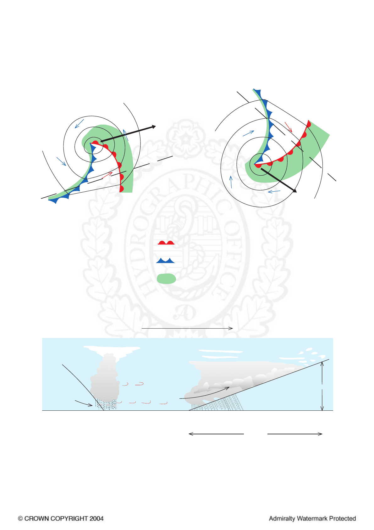
WARM
AIR
(WARM SECTOR)
WARM
AIR
(WARM SECTOR)
COLD
AIR
COLD
AIR
COLD
AIR
COLD
AIR
L
L
PATH OF
DEPRESSION
PATH
OF
DEPRESSION
NORTHERN
HEMISPHERE
SOUTHERN
HEMISPHERE
X
X
Y
Y
WARM
FRONT
PRECIPITATION
COLD
FRONT
(a) Plan of a Depression
(b) Plan of a Depression
(c) Section through Depression at XY
DIRECTION OF MOVEMENT
X
Y
Depressions (5.16)
8000m
COLD AIR
WARM AIR
COLD
AIR
500 MILES
WARM
FRONT
WARM SECTOR
COLD
FRONT
CHAPTER 5
114
Home
Contents
Index

CHAPTER 5
115
4 The configuration of fronts within the depression
circulation as shown in Diagram 5.17 is a normal and
characteristic feature of middle latitude depressions.
5.18
1 Warm front. When the air in the warm sector of the
depression meets the denser cold air on the frontal
boundary, the warm air overrides it; extensive cloud and
precipitation covering a wide area result as the warm air
ascends. The slope of the frontal discontinuity is about 1 in
100 so that the ascending warm air eventually reaches the
upper atmosphere some 500 miles ahead of the surface
frontal boundary and cirrus cloud at around 25 000–
30 000 ft is often the first sign of the approaching system.
5.19
1 Cold front. The cold air behind the front overtakes the
warm air of the warm sector and undercuts it, causing the
less dense warm air to rise; often quite suddenly so that a
belt of large cumulus or cumulonimbus cloud results.
Associated weather are squalls and heavy thunder showers
but the frontal belt of bad weather is usually much
narrower than at a warm front; but as no frontal cloud
precedes the cold front there may be little warning of its
approach. The “tail” of a cold front trailing behind a
depression is commonly the place of origin for further
wave depressions.
5.20
1 Occlusion. In a frontal system the cold front generally
moves faster than the warm front and eventually overtakes
it, thereby closing or occluding the warm sector of the
depression. Thereafter the cold front may displace the
warm front (see Diagram 5.20) effectively leaving a surface
cold front with mixed characteristics of both warm and
cold fronts: a “cold occlusion”. Alternatively when the air
behind the cold front is less dense than the air ahead of the
warm front, the cold front will rise up the warm frontal
discontinuity effectively leaving only a warm front at the
surface but again with mixed characteristics of both warm
and cold fronts: a “warm occlusion”.
2 In both cases the air in the warm sector is lifted from
the surface and the depression subsequently becomes less
active and starts to fill.
Weather
5.21
1 The following typical sequence of weather is likely as a
middle latitude depression approaches and passes. It must
be emphasised however that individual depressions in
different localities can differ considerably from each other
according to the physical characteristics of the constituent
air masses and the nature of the surface over which they
are travelling.
The approach of a depression is indicated by a falling
barometer.
5.22
1 If a depression is approaching from the W and passing
on the poleward side of the observer high cirrus clouds
appear in the W and the wind shifts to the SW or S in the
N hemisphere, or to the NW or N in the S hemisphere, and
freshens. The cloud layer increases to give overcast skies
which gradually obscure the sun; as the cloud becomes
progressively lower rain, or snow, at first intermittent,
becomes continuous and heavier. As the warm front passes,
the wind veers in the N hemisphere, or backs in the S
hemisphere, the fall of the barometer eases and the
temperature rises as the rain stops or moderates.
2 In the warm sector cloudy skies are usual; any
precipitation is usually drizzle and visibility is often
moderate or poor. If the sea surface temperature is low, fog
banks may develop.
The arrival of the cold front is marked by the approach
from the W of a thick bank of cloud: it is often obscured
by the extensive low cloud of the warm sector. As the front
passes, a further veer of the wind to W or NW in the N
hemisphere, or backing to W or SW in the S hemisphere,
may be accompanied by a squall. A belt of heavy rain, hail
or snow precedes the arrival of cooler, clearer air as the
barometer begins to rise.
3 As the depression recedes, showery conditions may
develop; a second cold front similar in character to the first
one sometimes marks the arrival of yet colder air.
When the depression is occluded the weather sequence
ahead of the front is similar to the approach of a warm
front; but as the front passes, a short period of heavy rain
may occur as the cold air behind the front arrives, and the
wind veers in the N hemisphere, or backs in the S
hemisphere. An old occlusion gradually assumes the
character of a warm or cold front according to the
respective temperatures of the air ahead of and behind the
front.
4 It frequently happens that another depression follows
12–24 hours later in which event the barometer again
begins to fall as the wind veers towards the SW or S in the
N hemisphere, or to the NW or N in the S hemisphere.
5.23
1 If a depression travelling E or NE in the N hemisphere,
or E or SE in the S hemisphere, is passing on the opposite
side of the observer to the pole the winds ahead of the
system will be E, then backing through NE to N or NW in
the N hemisphere, or veering through SE to S or SW in
the S hemisphere, as the depression passes by. Changes of
wind direction and speed are gradual and unlikely to be so
sudden as on the opposite side of a low to the pole. But
near the centre of a depression winds may temporarily fall
light and variable before strong or gale force winds set in
rapidly as pressure begins to rise and the low moves away.
There is often a long period of continuous rain and
unpleasant weather with low cloud especially when the
centre of the depression passes close by.
2 A secondary depression may sometimes develop in the
circulation of a large low, usually on the equatorial side
and often on the cold front. The secondary initially moves
with the primary depression, embedded in the circulation,
but the secondary may deepen rapidly to become a
vigorous system and give strong or gale force winds in
unexpected localities. In some cases the primary low may
fill whilst the secondary intensifies to become the dominant
feature.
Tropical storms
General information
5.24
1 Tropical storms are intense depressions which develop in
tropical latitudes; they are often the cause of very high
winds and heavy seas. Although the pressure at the centre
of a tropical storm is comparable to that of an intense
middle latitude depression, the diameter of a tropical storm
is much smaller (typically some 500 miles compared with
1500 miles) and thus the related pressure gradients and the
wind speeds are correspondingly greater. The wind blows
around the centre of a tropical storm in a spiral flow
Home
Contents
Index
COLD POLAR AIR
WARM TROPICAL AIR
C
C
P
A
T
H
O
F
W
A
V
E
PATH OF WAVE
A
A
AC
B
B
AC =
STATIONARY
SURFACE BOUNDARY
OR FRONT
SMALL WAVE
DEVELOPING
AT B
CIRCULATION
AROUND B
AB = COLD FRONT
BC = WARM FRONT
(1)
(2)
(3)
C
O
O
L
A
I
R
WARM AIR
W
A
R
M
A
IR
C
O
O
L
A
I
R
Formation of fronts in the N Hemisphere (5.17)
CHAPTER 5
116
Home
Contents
Index
COLD
AIR
COLD
AIR
COLD
AIR
COLDER
AIR
COLD
AIR
COLD
AIR
L
L
WARM
FRONT
PRECIPITATION
COLD
FRONT
OCCLUSION
OCCLUSION
WARM
AIR
WARM
AIR
WARM AIR
NORTHERN
HEMISPHERE
SOUTHERN
HEMISPHERE
X
X
X
Y
Y
Y
(a) Plan of a Depression
(b) Plan of a Depression
(c) Section through Cold Occlusion at XY
Occlusions (5.20)
CHAPTER 5
117
Home
Contents
Index
CHAPTER 5
118
inwards, anticlockwise in the N hemisphere and clockwise
in the S hemisphere: hence the occasional alternative name
“revolving storm”.
2 Within the circulation of a tropical storm the wind is
often very violent and the seas are high and confused;
considerable damage may be done even to large and
well-found ships. The danger is especially enhanced when
ships are caught in restricted waters without adequate room
to manoeuvre and early action may be essential to preclude
such a situation arising.
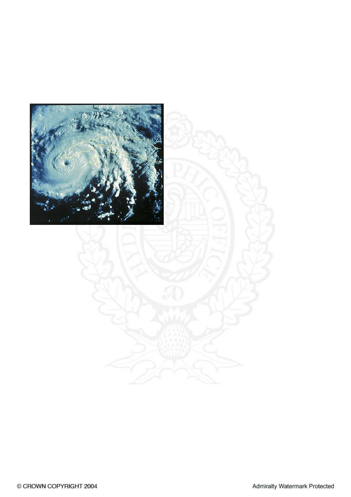
View of a hurricane from a satellite
Characteristics
5.25
1 Winds of gale force (above 34 kn) are likely up to
100–200 miles from the centre of a storm at latitudes of
less than 20°; as a storm moves to higher latitudes it tends
to expand and by the time a system has reached 30°–35°
(N or S) these distances may be doubled. Hurricane force
winds (above 64 kn) are likely within 80 miles of a storm
centre in the tropics and mean wind speeds of well over
100 kn have been recorded in major storms. Winds are
extremely gusty and the wind speeds in gusts may be some
30–50% higher than the mean; gusts exceeding 175 kn have
been reported. At the centre of a well-developed storm is a
characteristic area, known as the “eye” of the storm, within
which winds are light or moderate variable, the sky partly
cloudy but with a heavy sometimes mountainous, and
confused swell. The diameter of the eye can vary from less
than 10 miles in small intense storms to 30–40 miles in the
very large storms. Surrounding the eye is the dense dark
wall cloud extending to a great altitude and with very
heavy rain beneath; maximum wind speeds are attained at
the inner margin of the wall cloud in a belt averaging
about 5–15 miles in width. In this zone visibility is almost
nil due to the spray and torrential rain.
Occurrence
5.26
1 The localities, seasons, average frequencies and local
names of these storms are shown in Table 5.26. They are
most frequent during the late summer and early autumn of
each hemisphere; they are comparatively rare from
mid-November to mid-June in the N hemisphere and from
mid-May to November in the S hemisphere. However it is
stressed that no month is entirely safe and that storms can
occur at any time.
Formation and movement
5.27
1 Tropical storms develop only over oceans, and
origination is especially frequent near the seasonal location
of the Equatorial Trough. In the N hemisphere storms form
mostly in the belt 5°–15°N early and late in the storm
season, and between 10°N and 25°N at the height of the
season; in the N Atlantic Ocean storm formation between
25°N and 30°N is fairly common. In the S hemisphere
most storms develop between 5°S and 18°S. Those which
affect the W Pacific, S Indian and N Atlantic Oceans are
usually first reported in the W part of these oceans; there
are exceptions such as in the N Atlantic Ocean during
August and September when an occasional storm originates
near Arquipélago de Cabo Verde.
2 Tracks followed are very variable in all areas and
individual tracks may be quite erratic, but very generally, in
the N hemisphere a storm will move off in a direction
between 275° and 350° though most often within 30° of
due W. When near latitude 25°N storms usually recurve
away from the equator and by the time they reach 30°N
movement is in a NE direction. In the S hemisphere initial
movement is between WSW and SSW (usually the former)
to recurve between 15°S and 20°S and thence follow a SE
path. Many storms, however, do not recurve but continue in
a WNW direction in the N hemisphere, or WSW in the S
hemisphere. When a storm moves inland it weakens and
eventually dissipates; but if it should re-emerge to follow
an ocean track again it may re-intensify. The speed of
storms is usually about 10 kn in their early stages
increasing slightly with latitude but seldom exceeding 15 kn
before recurving. A speed of 20–25 kn is usual after
recurving through speeds of over 40 kn have been recorded.
When storms move erratically, sometimes making one or
more complete loops, their speed of movement is usually
slow; less than 10 kn.
5.28
1 Detection and tracking of tropical storms is greatly
assisted by weather satellites and most storms are detected
at a very early stage of development; thereafter each storm
is carefully tracked and in some areas storms are monitored
by weather reconnaissance aircraft which fly into the
circulations to record observations.
5.29
1 Storm warnings of the position, intensity and expected
movement of each storm are broadcast at frequent and
regular intervals. Details of stations which transmit
warnings, the areas covered and transmission schedules are
given in Admiralty List of Radio Signals Volume 3.
2 The following terms are in general use to describe
tropical circulations at various stages of intensity:
Tropical Depression Winds of force 7 or less
Tropical Storm Winds of force 8 and 9
Severe Tropical Storm Winds of force 10 and 11
Typhoon, Hurricane, Cyclone Winds of force 12
3 The Weather Centres issuing Storm Warnings and
advisory messages are generally manned by competent
forecasters of long experience with an optimum supply of
available information at their disposal. However it is
sometimes difficult to identify the precise position of a
storm centre, even with modern tracking facilities; and in
view of the uncertain movement of storms, prediction of
the future path of a storm may be liable to appreciable
error particularly when forecasting for several days ahead.
Home
Contents
Index
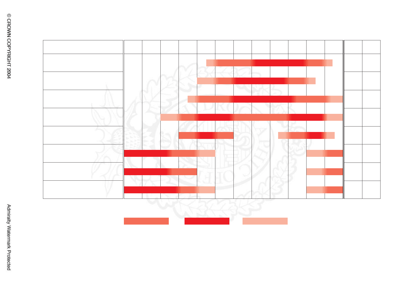
Area & Local name
North Atlantic, West Indies
region (hurricane)
North-East Pacific (hurricane)
North-West Pacific (typhoon)
North Indian Ocean
Bay of Bengal (cyclone)
North Indian Ocean
Arabian Sea (cyclone)
South Indian Ocean
W of 80°E (cyclone)
Australia W, NW, N coasts &
Queensland coast (hurricane)
Fiji, Somoa, New Zealand
(North Island) (hurricane)
Jan Feb Mar May Jun
Jul Aug Sep Oct Nov Dec A
10
15
25-30
2-5 1-2
1-2
5-7
2-3
1
2
1
27
15-20
5
7
B
Apr
Table showing principal areas affected and months in which tropical storms normally occur
Tropical Storm Table
Table (5.26)
Column A: Approximate average frequency of tropical storms each year
Column B: Approximate average frequency of tropical storms each year which develop Force 12 winds or stronger
Start/Finish of season Period of greatest activity
Period affected when season early/late
CHAPTER 5
119
Home
Contents
Index