Hooke R.L. Principles of glacier mechanics
Подождите немного. Документ загружается.

Basal temperatures in Antarctica 141
-5
-5
Areas at the pressure
melting temperature
Areas below -10
o
C
0 1000 km
-10
-5
-20
-20
-30
-30
-30
-20
-10
Areas at the pressure
melting temperature
Areas below -10
o
C
0 1000 km
Q
u
e
e
n
M
a
u
d
L
a
n
d
Ice
shelf
Ice
shelf
(a)
(b)
-10
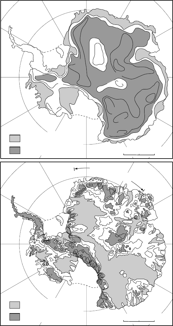
Figure 6.15. (a) Basal
temperatures,
◦
C, from the
Column model; (b) basal
temperatures,
◦
C, calculated
by Ph. Huybrechts, especially
for this book, using the model
described in Huybrechts
(2002). ((a) Modified from
Budd et al., 1971. Reproduced
with permission of the
Australian Antarctic Division.)

142 Temperature distribution in polar ice sheets
Budd et al.were using balance velocities that were an order of magni-
tude higher than Huybrechts in this sector, thus overemphasizing strain
heating.
The differences between the temperature distributions in Figure 6.15
emphasize the need for caution in using the Column model. However,
the Column model does illustrate the basic physical factors affecting the
temperature distribution in ice sheets, and can be used to obtain reason-
able estimates of the temperature distribution with only a calculator or
spreadsheet. For geomorphologists wishing to test ideas on the origin of
certain landforms, for example, the errors introduced by the simplifying
assumptions made in the Column model are probably no greater than
the uncertainties in the ice age values of parameters like b
n
, H, β
b
and u
that are used in it.
Geomorphic implications
Temperature distributions such as that in Figure 6.12 have implications
for glacial erosion and deposition and the origin of some glacial land-
forms. Erosion rates are likely to be highest where basal melt rates are
low, and particularly where meltwater is refreezing to the glacier sole.
Thus, we might expect to find that erosion was most intense some dis-
tance from the divide. Conversely, the formation of lodgment till by
subglacial melting should be most prevalent beneath the ablation zone.
Both are consistent with observation.
The calculations shown in Figure 6.12 also suggest that zones of
frozen bed, a couple of kilometers wide, should develop along ice sheet
margins in regions where mean annual temperatures are sufficiently low.
This, indeed, seems to have been the case in North Dakota and adjacent
areas of Alberta and Saskatchewan. Here, blocks of bedrock, tens to
hundreds of meters on a side, became frozen to the base of the glacier
and were moved outward a kilometer or so (Figure 6.16). Detachment
may have been facilitated by high pore-water pressures in the unfrozen
rock beneath the frozen zone. Upon deposition, these blocks formed
hills. When the ice eventually receded, the basins from which the blocks
were plucked became lakes (Moran et al., 1980).
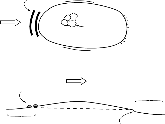
In some places, subglacial frozen bed conditions persisted through-
out the last glacial period. The best studied such areas are in western
Sweden, in the divide region of the Weichselian ice sheet. These cold
zones were probably a consequence of a combination of high accu-
mulation rates, cold temperatures, and thin ice in the topographically
high divide region. Relict periglacial landforms like patterned ground
(Kleman and Borgstr¨om, 1994) and weathering features such as tors
(Kleman and H¨attestrand, 1999) are found in these areas. These features
Geomorphic implications 143
Detachment
u
Unfrozen
Frozen
2–3 km
Lake
Hill
Former ice sheet
Figure 6.16. Hill–lake pair formed by thrusting at a frozen margin.
developed under ice-free conditions during the last interstadial. Around
the edges of these zones of relict landscape, frozen bed conditions per-
sisted on higher ground while lower areas were at the pressure melting
point. Kleman and Borgstr¨om (1994)have described a distinctive set of
landforms in such situations (Figure 6.17). Up- and downglacier from the
higher areas the ice was sliding, whereas it remained frozen to the sub-
strate over the hill itself. This led to longitudinal compression on the stoss
side of the hill, and longitudinal extension on the lee side. Till dragged
by the ice thus became stacked in transverse moraines on the stoss side.
On the lee side it was pulled away, forming an abrupt scarp (Figure 6.17).
Along the lateral boundaries, there is a narrow transition separating the
relict surface from an area of glacially modified topography.
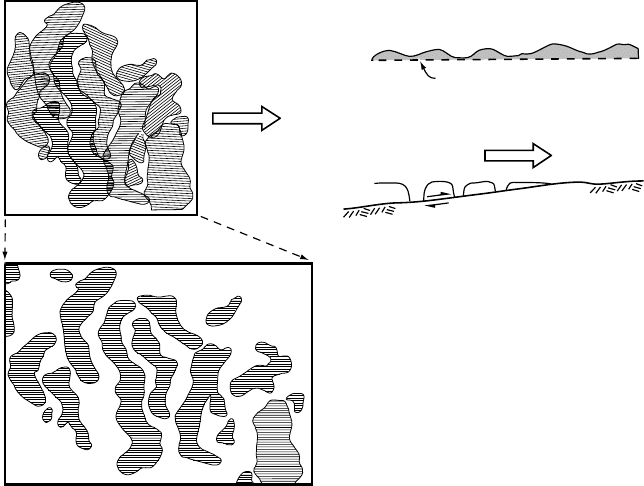
Ribbed moraine is another distinctive landform that is commonly
present around the edges of areas where frozen bed conditions either per-
sisted throughout a glaciation or perhaps developed during deglaciation
(H¨attestrand and Kleman, 1999). Ribbed moraines are anastomosing,
somewhat sinuous ridges oriented transverse to ice flow (Figure 6.18a).
The ridges typically consist of glacial drift similar to that in adjacent
areas without ridges. The drift is usually till but may be glaciofluvial
sediment or a combination of the two. In troughs between ridges, seis-
mic investigations and limited exposures suggest that the drift sheet is
generally thin or missing (Figure 6.18c). If one could decouple the ridges
from the substrate and slide them together, they would fit remarkably well
(Figure 6.18b). These characteristics suggest that the ridges were formed
by pull-apart of a once-continuous drift sheet at the boundary between
zones of thawed and frozen bed (Figure 6.18d). H¨attestrand and Kleman
have argued convincingly that this is the case. They have shown that
ribbed moraine is confined almost exclusively to the core areas of late
Pleistocene ice sheets. They find that the ridges are transverse to ice flow
directions during deglaciation and not to flow directions during the Late
Glacial Maximum, suggesting that they formed during deglaciation.
As our understanding of the origin and distribution of features such
as hill–hole pairs, relict surfaces, and ribbed moraine improves, they
will become increasingly valuable in constraining numerical models
144 Temperature distribution in polar ice sheets
(b)
Stoss side
moraines
Patterned ground
Compressive
flow
Frozen
Unfrozen
Extending flow
Transverse
till scarp
Ice flow
Transverse
till scarp
Lateral sliding boundary
Stoss side
moraines
Ice
flow
(a)
Patterned
ground
Figure 6.17. Schematic map (a) and cross section (b) through a low hill that
remained frozen throughout a glacial advance and on which periglacial
landforms are thus preserved. Stoss side moraines were formed in the zone of
compressive ice flow on the stoss side of the hill, and transverse till scarps were
formed on the lee side.
of Pleistocene ice sheets. Some modeling studies have already used
the distribution of these features for this purpose (see, for example,
Fastook and Holmlund, 1994; Moran et al., 1980)but much remains to be
done.
Summary
We began this chapter by deriving the energy balance equation. Given
boundary conditions appropriate for a polar ice sheet, solutions to this
equation yield the temperature distribution in the ice sheet. The boundary
conditions most commonly used are: (1) the temperature at the surface,
which is approximated by the mean annual temperature, perhaps with a
correction for heating by percolating melt water; and (2) the temperature
gradient at the bed. The latter is based on estimates of the geothermal
Summary 145
Decollément
Ice flow
Unfrozen
Frozen
(a)
(d)
Ice flow
(c)
(d)
60% extension
Figure 6.18. Formation of ribbed moraine. (a) Map of ribbed moraine ridges
near Lake Rogen in west-central Sweden. The line pattern on the ridges shows
the direction of faint fluting. (b) Inferred original relative positions of ridges.
Areas of overlap are attributed to streamlining after the ridges were pulled apart.
(c) Schematic cross section through a series of ridges showing thickness of
material above decoll
´
ement. (d) Schematic diagram showing how a layer of
frozen soil overlying thawed material could be pulled apart by extensional flow
in the ice. ((a) and (b) from H
¨
attestrand and Kleman, 1999. Reproduced with
permission of the authors and Elsevier Science.)
flux. If calculations suggest that the bed is at the pressure melting point,
the temperature gradient is adjusted to ensure that calculated basal tem-
peratures do not exceed the melting point.
By using appropriate simplifications, we studied solutions to the
energy balance equation for the situation at an ice divide, for the situa-
tion near the glacier surface but some distance from the divide, and for
a column of ice extending through an ice sheet some distance from the
divide. Two key assumptions in the latter, the so-called Column model,
are that w decreases linearly with depth and that longitudinal advection
can be approximated by assuming a warming rate at depth that equals that
at the surface. Both of these lead to basal temperatures that are too cold,
and the second may result in physically impossible temperature distri-
butions in areas where surface temperatures are changing rapidly in the
longitudinal direction. With suitable caution, however, we found that the
146 Temperature distribution in polar ice sheets
Column model was useful for illustrating how various physical processes
that affect the temperature distribution were reflected in calculated tem-
peratures along a flowline of the Laurentide Ice Sheet. Comparison of
basal temperatures beneath the Antarctic ice sheet calculated by using
the Column model and with a state-of-the-art numerical model served
to emphasize both the value and the limitations of the former.
Finally, we discussed some geomorphic features formed at bound-
aries between zones of thawed and frozen bed, and noted that these could
be used to constrain numerical models of ice sheets.
Chapter 7
The coupling between a glacier and
its bed
In Chapter 4 we found that the rate of deformation of ice, ˙ε
e
, could be
related to the applied stress, σ
e
,by:˙ε
e
=
(
σ
e
/B
)
n
(Equation (4.5)). The
rigorous basis for this flow law will not be developed until Chapter 9,
but some indications of the complexities involved in applying it have
already been mentioned. Despite these complexities, calculations using
it are reasonably accurate. Computed deformation profiles are an exam-
ple. This is, in large part, because ice is a crystalline solid with relatively
uniform properties. The principal causes of inaccuracy in such calcu-
lations are a consequence of impurities in the ice, including water, of
anisotropy associated with the development of preferred orientations of
crystals, and of incomplete knowledge of the temperature and boundary
conditions.
As mentioned briefly in Chapter 5 (Figure 5.5), glaciers also move
over their beds readily when the basal temperature is at the pressure
melting point. However, the rate at which this movement occurs is far
more difficult to analyze. This is again, in part, because the boundary
conditions, principally the water pressure and the morphology of the
bed, are not known. However, a more fundamental problem is the fact
that granular rock debris is usually present, either in the ice or between
the ice and the bed, or both. There is considerable uncertainty surround-
ing the processes involved in the deformation of such material and the
appropriate constitutive relations describing its deformation and that of
ice containing it. Furthermore, unlike the situation with pure ice, the
properties of the rock debris vary, not only from glacier to glacier, but
also from point to point beneath a single glacier.
147
148 The coupling between a glacier and its bed
Figure 7.1. Bed geometry
used in Weertman’s (1964)
analysis of basal sliding.
Although it may be impossible to know the boundary conditions
well enough to predict accurately the rate of movement of a glacier over
its bed, it is nevertheless important to understand the processes in order
to place limits on the rate. Thus, a significant effort has been made to
analyze these processes, using judicious assumptions where necessary
as a substitute for detailed data. This analysis has led to relations between
the rate of movement and measurable quantities such as water pressure
and driving stress that can be tested with field data.
We start this discussion by looking at the movement of clean ice
over an irregular hard rigid bed – the traditional sliding problem. Some
of the principal shortcomings of the analysis are then discussed. Finally
we take up the problem of deformation of the granular materials over
which many glaciers move.
Sliding
The basic processes by which ice moves past an obstacle on a rigid bed,
regelation and plastic flow, were first discussed by Deeley and Parr (1914)
and later quantified by Weertman (1957a, 1964). Regelation involves
melting of ice in the region of high pressure on the upglacier or stoss side
of the obstacle and refreezing of that water in the region of lower pres-
sure on its lee face. Plastic flow is simply deformation of ice in a three-
dimensional flow field around the obstacle. In his analysis, Weertman
used a simplified model of the bed geometry, sometimes called the tomb-
stone model, consisting of uniformly spaced rectangular blocks on a flat
surface (Figure 7.1). This model has been roundly criticized as being
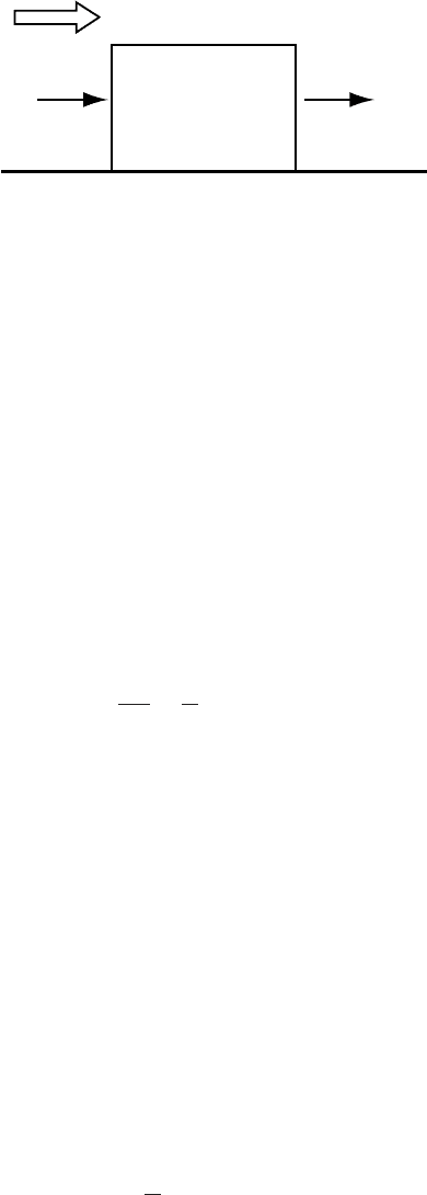
Sliding 149
s
s
s
l
Ice flow
Higher pressure,
Colder
Lower pressure,
Warmer
Figure 7.2. Pressure and
temperature on stoss and lee
sides of a rectangular bump
on a glacier bed.
unrealistic, and inappropriately defended by arguing that fudge fac-
tors can be inserted to make it applicable to real situations. The real
value of the model is that the physical principles involved in the sliding
process are illustrated without resorting to sophisticated mathematical
techniques.
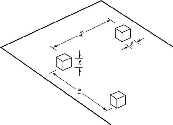
Consider the bed shown in Figure 7.1.For simplicity we will use
cubical obstacles with sides of length, , instead of Weertman’s rectan-
gular ones. The mean spacing between obstacles is
L, and we therefore
define r = /
L as the roughness of the bed. The mean drag on the bed is
τ .Asthe ice is separated from the bed by a thin film of water, we assume
that faces parallel to the flow cannot support a shear stress. Thus the
entire drag over an area
L
2
must be supported by one obstacle. The total
force on the obstacle is then F =τ
L
2
,sothe stress difference across the
obstacle, σ
s
− σ
l
, is:
σ
s
− σ
l
=
τ
L
2
2
=
τ
r
2
(7.1)
where the subscripts, s and l, refer to stoss and lee, respectively.
Regelation
Let us deal with regelation first. The average temperature at the bed
is constrained to be at the pressure melting point determined by the
average pressure in the water layer. The average pressure is a function
of the local glacier thickness. The pressure in the water film on the
stoss face of the obstacle is higher than the average, and the pressure
on the lee face is lower (Figure 7.2). We denote the pressure difference
across the obstacle, σ
s
− σ
l
,byP. This pressure difference results in a
temperature difference, T = CP,where C is the change in melting
temperature with pressure (Equation (2.2)).
The temperature difference across the obstacle, from Equation (7.1),
is thus:
T = C
τ
r
2
(7.2)

150 The coupling between a glacier and its bed
and the temperature gradient through it is T/. The heat flow through
the obstacle is thus:
Q =
T
K
r
2
= TK
r
(7.3)
where
2
is the cross-sectional area of the obstacle and K
r
is the ther-
mal conductivity of rock. K
r
has the dimensions J m
−2
s
−1
(K/m)
−1
,or
Jm
−1
s
−1
K
−1
.Atypical value for rock or ice is 2.2. Q has the dimensions
Js
−1
.
This heat flow can melt ice at a rate Q/Hρ,where H is the heat of
fusion, 3.3 × 10
5
Jkg
−1
, and ρ is the density of ice, ∼900 kg m
−3
.
Thus, the melt rate is expressed in m
3
s
−1
.Dividing this rate by the
cross-sectional area of the obstacle,
2
,gives the speed with which ice
can move past the obstacle by regelation, S
r
. Thus, using Equations (7.2)
and (7.3):
S
r
=
Q
2
Hρ
=
Cτ K
r
Hρr
2
(7.4)
In reality, some heat also flows from the low-pressure region to the high
pressure region through the ice above the obstacle and through the rock
beneath it, so this relation slightly underestimates S
r
.
The water formed by melting in the high-pressure area on the stoss
side of the obstacle flows either upglacier or downglacier to areas of
lower pressure. The area of low pressure in the lee of the obstacle that
we have been analyzing is one such sink. Because heat is conducted
away from this area by the temperature gradient through the obstacle,
this water refreezes. Thus, to complete the regelation cycle, the water
flux to the lee of the obstacle must equal the melt on the stoss side. We
will examine the consequences of a failure of this condition later, and
consider plastic flow next.
Plastic flow
Plastic flow (or creep) of ice around an obstacle clearly must contribute to
flow of a glacier past the obstacle. Weertman suggested that this plastic
flow is enhanced owing to the high stresses on the obstacle. He thus
assumes that the speed with which ice moves past the obstacle by this
process, S
p
,isproportional to and to the creep rate obtained by using
the stress difference from Equation (7.1)intheflow law:
S
p
= b˙ε = b
τ
Br
2
n
(7.5)
where b is a dimensionless constant of proportionality. Note that dimen-
sionally ˙ε is a speed.