Groshong Richard H. 3-D Structural Geology(Second Edition)
Подождите немного. Документ загружается.

56 Chapter 2 · Location and Attitude
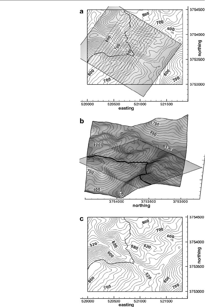
Fig. 2.25.
Intersection between topo-
graphic contours and a planar
marker horizon. Contour in-
terval 20 ft. a Structure con-
tours on a geologic horizon
(within shaded rectangle) and
topographic contours. The out-
crop trace of the contact is the
thick line. b Oblique 3
-D view
to E. c Geologic map of the
outcrop trace (thick line) with
the structure contours of the
plane removed

57
identical elevations are marked. Additional topographic and structural contours can
be interpolated to add additional control. Marking the intersection points is most
convenient if the topographic map is on a transparent overlay that can be placed above
the structure contour map, something that is easily done in computer drafting pro-
grams. A 3
-D view of the intersecting surfaces (Fig. 2.25b) helps in understanding the
procedure. The intersection points are connected to obtain the outcrop pattern of the
horizon (Fig. 2.25c). The inferred outcrop pattern becomes a working hypothesis for
the location of the horizon. Exactly the same procedure is used to find the intersection
between a fault and a stratigraphic marker or the line of intersection between two faults.
2.8
Derivation: Tangent Diagram on a Spreadsheet
To plot a tangent diagram with a spreadsheet it may be necessary to shift the origin for
the azimuth (Az) from zero to the east to zero to the north using
Az = Az – 90 . (2.23)
Change the dip to the tangent of the dip,
r = tan (dip) , (2.24)
and change from polar to Cartesian coordinates with
x = r cos (Az) , (2.25a)
y = r sin (Az) . (2.25b)
The native angle format in spreadsheet trigonometric functions is radians and so where
angles in degrees are used in trigonometric expressions they must always be converted to
degrees from radians. Plot the transformed points as an xy graph in the spreadsheet.
2.9
Exercises
2.9.1
Interpretation of Data from an Oil Well
The Appleton oil field is located near the northern rim of the Gulf of Mexico basin.
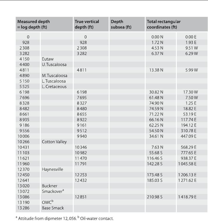
Use the data from well 4835
-B in this field (Table 2.2) to solve the following problems.
Find the subsea depths of the stratigraphic markers. Write a spreadsheet program using
Eqs. 2.3 and 2.4 to find the coordinates of a point between two known points. Find the
true vertical depths and the total rectangular coordinates of the formation contacts in
the well. What is the orientation of the well where it penetrates the Smackover? Write
a spreadsheet program to solve this problem based on Eq. 2.4. Find the true vertical
depths and the total rectangular coordinates of the oil-water contact (OWC) and the
2.9 · Exercises
58 Chapter 2 · Location and Attitude
base of the Smackover. Plot the locations of the stratigraphic tops relative to the sur-
face location of the well on the map (Fig. 2.26). Connect the points to show the shape
of the well in map view. How far from the well (horizontally and in which direction)
would you expect to first find the intersection of the oil
-water contact with the top of
the Smackover Formation, assuming constant dip for the Smackover?
2.9.2
Attitude
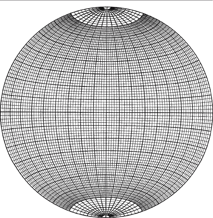
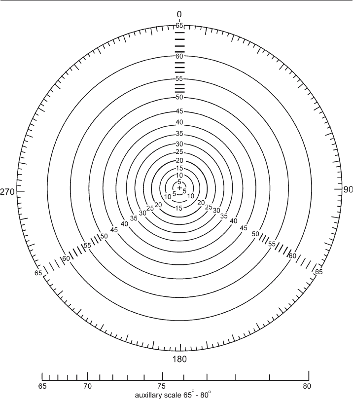
Given the dip vector of the plane 35, 240, show on an overlay of a stereogram the trace
of the plane, its dip vector, and its pole. Show the dip vector 25, 240 on a tangent dia-
gram. What is the apparent dip along a line that trends 260?
Table 2.2. Data from well 4835-B, Appleton field, Alabama. Kelly Bushing: 244 ft
59
2.9.3
Attitude from Map
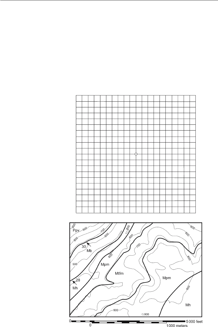
Use the map of the Blount Springs area (Fig. 2.27) to answer the following questions. Find
the attitude of the Mpm in its southeastern outcrop belt using the 3-point method. Draw
structure contours for the Mtfp, Mpm, and Mh on the eastern side of the map. Are the
upper and lower contacts of each unit parallel to each other? Do you think the contacts
are mapped correctly? Determine the attitude of the eastern contact between the Mpm
and the Mtfp by the 3
-point method and from the structure contours. Are they the same?
If they are different, discuss which answer is better. What would be the apparent dip of
the Mpm in a north-south roadcut through the northwestern limb of the anticline?
Fig. 2.26.
Map grid for plotting
points in a deviated well
2.9 · Exercises
Fig. 2.27.
Geological map of the north-
east corner of the Blount
Springs area, southern Appa-
lachian fold
-thrust belt. Thin
lines are topographic contours
(elevations in feet). Thick lines
are geologic contacts. Arrows
are dip directions; numbers
give the amount of dip
60 Chapter 2 · Location and Attitude
Fig. 2.28. Equal-area stereogram
61
Fig. 2.29. Tangent diagram
2.9 · Exercises

Chapter 3
3.1
Introduction
This chapter covers the basic techniques for contouring continuous surfaces and for
the construction of composite
-surface maps. The contouring of faults and faulted sur-
faces is treated in Chap. 7.
3.2
Structure Contouring
A structure contour map is one of the most important tools for three-dimensional
structural interpretation because it represents the full three
-dimensional form of a
map horizon. The mapping techniques to be discussed are equally applicable in sur-
face and subsurface interpretation. The usual steps required to produce a structure
contour map are:
1. Plot the points to be mapped.
2. Determine an appropriate contour interval.
3. Interpolate the locations of the contour elevations between the control points. There
are several techniques for doing this and they may give very different results when
only a small amount of data is available.
A structure contour map is constructed from the information at a number of obser-
vation points. The observations may be either the xyz positions of points on the sur-
face, the attitude of the surface, or both. A relatively even distribution of points is
desirable and which, in addition, includes the local maximum and minimum values of
the elevation. If the data are from a geologic map or from 2
-D seismic-reflection pro-
files, a very large number of closely spaced points may be available along widely spaced
lines that represent the traces of outcrops or seismic lines, with little or no data be-
tween the lines. The number of points in a data set of this type will probably need to
be reduced to make it more interpretable. Even if the contouring is to be done by com-
puter, it is possible to have too much information (Jones et al. 1986). This is because
the first step in contouring is always the identification of the neighboring points in all
directions from a given data point and it is difficult and usually ambiguous to choose
the neighbors between widely spaced lines of closely spaced points. Before contouring,
the lines of data points may need to be resampled on a larger interval that is still small
enough to preserve the form of the surface.
Structure Contouring

64 Chapter 3 · Structure Contouring
A series of rules for contouring has been developed over the years to produce
visually acceptable maps that reasonably represent the surface geometry. The ref-
erence frame for a contour map is defined by specifying a datum plane, such as
sea level. Elevations are customarily positive above sea level and negative below sea
level. The contour interval selected depends on the range of elevations to be depicted
and the number of control points. There should be more contours where more
data are available. The contour interval should be greater than the limits of error
involved. Errors of 20 ft (7 m) are typical in correlating well logs and as a result
of minor deviations of a well from vertical. Uncertainties in locations in surface
mapping are likely to produce errors of similar magnitude. The contour interval
should be small enough to show the structures of interest. The map can be read
more easily if every fifth or tenth contour is heavier. The map should always have a
scale. A bar scale is best because if the map is enlarged or reduced, the scale will
remain correct.
The contour interval on a map is usually constant; however, the interval may be
changed with the steepness of the dips. A smaller interval can be used for low dips.
If the interval is changed in a specific area, make the new interval a simple multiple
(or fraction) of the original interval and clearly label the contour elevations and/or
show the boundaries of the regions where the spacing is changed on the map.
The contours must obey the following rules (modified from Sebring 1958; Badgley
1959; Bishop 1960):
1. Every contour must pass between points of higher and lower elevation.
2. Contour lines should not merge or cross except where the surface is vertical or is
repeated due to overturned folding or reverse faulting. The lower set of repeated
contours should be dashed.
3. Contour lines should either close within the map area or be truncated by the edge
of the map or by a fault. Closed depressions are indicated by hash marks (tic marks)
on the low side of the inner bounding contour.
4. Contour lines are repeated to indicate reversals in the slope direction. Rarely will a
contour ever fall exactly on the crest or trough of a structure.
5. Faults cause breaks in a continuous map surface. Normal separation faults cause
gaps in the contoured horizon, reverse separation faults cause overlapping contours
and vertical faults cause linear discontinuities in elevation. Where beds are repeated
by reverse faulting, it will usually be clearer to prepare separate maps for the
hangingwall and footwall.
6. The map should honor the trend or trends present in the area. Crestal traces, trough
traces, fold hinges and inflection lines usually form straight lines or smooth curves
as appropriate for the structural style.
Mapping by hand usually should begin in regions of tightest control and move
outward into areas of lesser control. It is usually best to map two or three contours
simultaneously in order to obtain a feel for the slope of the surface. The contours will
almost certainly be changed as the interpretation is developed; therefore, if drafting by
hand, do the original interpretation in pencil. The map should be done on tracing
paper or clear film so that it can be overlaid on other maps.
65
3.3
Structural Style in Contouring
Contouring may be done using different styles, each of which produces its own char-
acteristic pattern (Handley 1954). With a large amount of evenly spaced data, the differ-
ence between maps produced by different styles will usually be small. Contouring by
any method must be viewed as a preliminary interpretation because unknown struc-
tures can always occur between widely spaced control points. The characteristics of
the common styles of contouring are summarized next. Contours are usually shown as
smooth curves although this should depend on the structural style (Sect. 3.3.4). The
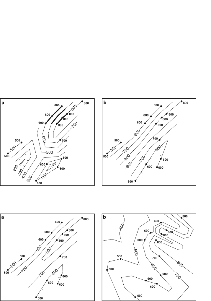
following examples (Figs. 3.1–3.2) are based on exactly the same points in order to
demonstrate the differences that can be achieved by different methods.
Fig. 3.1. Different contouring methods applied to the same control points (solid circles). a Equal-spaced
contouring. The dip to be maintained (heavy contours) is chosen in the region of tightest control. b Parallel
contouring
Fig. 3.2. Interpretive contouring; a based on interpretation that regional trends are northeast–southwest;
b based on the interpretation that the regional trends are northwest–southeast
3.3 · Structural Style in Contouring

66 Chapter 3 · Structure Contouring
3.3.1
Equal Spacing
Equal
-spaced contouring (Fig. 3.1a) is based on the assumption of constant dip mag-
nitude over as much of the map area as possible. In the traditional approach, the dip
selected is determined in an area of tightest control. The same dip magnitude is then
used over the entire map (Handley 1954; Dennison 1968). Find the dip from the con-
trol points with the three
-point method (Sect. 2.4), or, if the dip is known, as from an
outcrop measurement or a dipmeter, find the contour spacing from the dip (Eq. 2.21).
This approach projects dips into areas of no control or areas of flat dip and so will
create large numbers of structures that may be artifacts (Dennison 1968). Because of
the great potential for producing nonexistent structural closures, this method is usu-
ally not preferred (Handley 1954).
Equal-spaced contouring of the Mtfp (Fig. 3.1a) produces multiple closures, two an-
ticlines and a syncline that is much lower than any of the data points. The anticlinal
nose defined by the 800-ft contour is reasonable but the closed 700-ft anticline to the
south and the syncline bounded by the 200
-ft contour on the southwest are forced into
regions of low dip or low control.
3.3.2
Parallel
Parallel contouring is based on the assumption that the contours are parallel, in other
words, a strong linear trend is present. The contours are drawn to be as parallel as
possible and the spacing between contours (the dip) is varied as needed to maintain
the parallelism (Dennison 1968). The resulting map may contain cusps and sharp
changes in contour direction, but is good for areas with prominent fold trends (Tearpock
1992). The method tends to generate fewer closures between control points than equal
-
spaced contouring and more than linear interpolation (Tearpock 1992).
The parallel contouring of the top of the Mtfp (Fig. 3.1b) is strongly influenced by
the parallelism of the contours that can be drawn through the data points on the north-
west limb and on the southeast limb of the major anticline. This method suggests an
elongate northeasterly trending anticline in the center of the map and a southwest
-
plunging syncline on the southeast. The syncline is in the same position as the anti-
cline predicted by the equal
-spaced method (Fig. 3.1a).
3.3.3
Interpretive
Interpretive contouring reflects the interpreter’s understanding of the geology. The
preferred results are usually regular, smooth and consistent with the local structural
style and structural grain. Generally, the principle of simplicity is applied and the least
complex interpretation that satisfies the data is chosen.
Interpretive contouring (Fig. 3.2a) incorporates the knowledge that the structural
grain is northeast–southwest and that the regional plunge is very low. The main anti-
cline seen in each of the other techniques is present and is interpreted to be closed to
