Groshong Richard H. 3-D Structural Geology(Second Edition)
Подождите немного. Документ загружается.

77
structural trend. Nearest neighbors are the closest points on adjacent traverses. This
problem can be overcome by orienting traverses parallel and/or perpendicular to the
structural trend, or by mapping based on the structural trend (Sect. 5.5).
Non
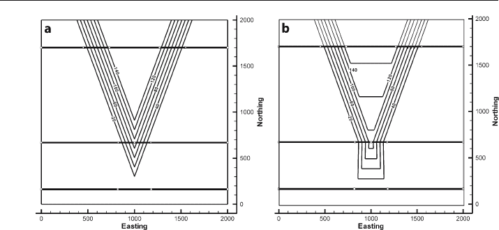
-cylindrical folds pose a greater challenge for accurate mapping. The fold in
Fig. 3.17a is a simple flat
-topped anticline with limbs that converge to the south and
disappear, giving a conical geometry. Sampled along three traverses perpendicular to
the average crestal trend, the reconstruction does only a fair job of reproducing the
original geometry. The fold limbs are reproduced but the flat crest and the plunging
nose are misrepresented. Mapping based on 3
-D dip domain interpretation (Sect. 6.7)
is the most accurate approach for this style of structure.
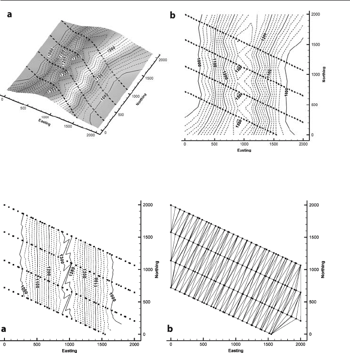
Fig. 3.15. Map made by inverse-distance interpolation (weighting exponent 3.5) of points along cross sections
from data in Fig. 3.14. Lines of black squares are control points. a Oblique view. b Structure contour map
Fig. 3.16. Map made by triangulation of points along cross sections from data in Fig. 3.14. Lines of
black squares are control points. a Structure contour map. b TIN network
3.5 · Mapping from Profiles
78 Chapter 3 · Structure Contouring
3.6
Adding Information to the Data Base
Structure contour maps can be based on a significant amount of information in addi-
tion to the elevations on a single horizon. The shape of the contoured surface can be
controlled using the attitudes of bedding, data from multiple stratigraphic horizons,
and from pore
-fluid behavior such as different groundwater levels or the presence or
absence of hydrocarbon traps as indicated by shows of oil and gas in wells. Finding the
structural trend and mapping based on trend are discussed in Chap. 5 and 6.
3.6.1
Bedding Attitude
If the bedding attitude is known from outcrop or dipmeter measurements (Fig. 3.18a),
it can be incorporated into the contouring. Attitudes at the well-bore or outcrop scale
can give insight into the shape of the surface but are subject to influence by small
-scale
structures. The contours are not required to have the same dip everywhere on the map.
The contour spacing will change as the dip changes. Structure contours are perpen-
dicular to the bedding dip. The distance between the contours is given by Eq. 2.21. In
the example of Fig. 3.18, for a contour interval of 100 and dip of 25°, the spacing be-
tween the contours at map scale is 214, giving the structure contour map in the vicinity
of the control point shown in Fig. 3.18b.
If mapping is customarily done at a standard scale, then a map
-spacing ruler
(Fig. 3.19) can be useful. A contour
-spacing ruler shows the spacing between contours
for a variety of dips, given the map scale and the contour interval. It is constructed
using Eq. 2.21. The ruler is oriented perpendicular to the structure
-contour (strike)
trend and the contour spacing for a given dip is easily plotted or the dip determined
from the contour spacing.
Fig. 3.17. Structure contour maps of a conical, dip-domain anticline. a Original map showing three
traverses where elevations have been extracted (heavy EW lines). b Map constructed by triangulating
points extracted from the three profiles in a

79
3.6.2
Projected and Composite Surfaces
A projected surface is a structure contour map derived entirely by projecting data from
other stratigraphic levels. A projected marker is sometimes called a ghost horizon.
Usually a projected surface is below the lowest control points. A typical use is to project
the subsurface location of an aquifer or an oil reservoir from outcrop or shallow sub-
surface information.
A composite surface is a structure contour map derived using data from multiple
stratigraphic horizons, including the horizon being mapped. One horizon is selected
as the reference surface and data from other stratigraphic horizons are projected up-
ward or downward to this horizon, using the known stratigraphic thicknesses. The
best choice of a reference horizon is one for which there is already a significant amount
of control and that minimizes the projection distance. Usually a reference horizon that
is stratigraphically in the middle of the best
-controlled units should be selected. The
data from multiple horizons provide increased control on the interpretation of the shape
of the reference horizon. This type of map is particularly useful in the interpretation
of outcrop data because the locations of all formation boundaries can be used to pro-
vide control points, greatly increasing the areal distribution of data.
An elevation on a marker surface is transformed into an elevation on a projected
surface by adding or subtracting the vertical distance between the two (Fig. 3.20). The
projection is made from a point where the elevation of the marker is known. This may
be the location of a surface outcrop (as in Fig. 3.20) or the elevation of a contact in a
well. The distance to the projected horizon is derived from the thickness of the unit by
Fig. 3.18.
Structure contour direction and
spacing from an attitude mea-
surement. a Dip vector at
a point having an elevation
of 800. b Structure contours
in the vicinity of the point.
For I = 100, H = 214
Fig. 3.19. Contour-spacing ruler
3.6 · Adding Information to the Data Base

80 Chapter 3 · Structure Contouring
d = t /cos
δ
, (3.1)
where d = vertical distance between the surfaces, t = true thickness, and
δ
= true dip
(Badgley 1959). The projection can be either up or down from the known point, that
is, from the marker horizon in Fig. 3.20 to either a or b. Be sure to use the same datum
(i.e., sea level) for all measurements. Projections from a surface map need to use the
topographic elevation to find the elevation with respect to sea level. Projections above
the surface of the earth are as valid as projections below the surface; it is not necessary
that the reference surface be confined to the subsurface.
If regional thickness variations are present, the thickness used for projection must
be adjusted according to the location. An isopach map (Chap. 4) provides the informa-
tion necessary to determine the thickness at specific points. In regions of low dip, the
difference between the vertical distance and the true thickness is small. In this situa-
tion an approximate projected surface can be derived by simply adding or subtracting
the thickness between the units to or from the elevation of the marker to obtain the
projected surface (Handley 1954; Jones et al. 1986; Banks 1993).
Projected data can greatly augment the information on a single horizon and can
lead to a significant improvement in the interpreted geometry of the structure. The
increase in data available for contouring may significantly improve the map on the
reference horizon. Inconsistent data on different horizons can be more easily recog-
nized when all data are projected to the same surface. Accurate projection requires
accurate knowledge of the unit thickness and the dip, both of which are likely to con-
tain uncertainties and so a certain amount of “noise” is to be expected in the projected
data set. The interpreted surface and the data will be iteratively improved as the incon-
sistencies are eliminated.
The creation of a composite surface map allows utilization of stratigraphic markers
that are not formation boundaries. The location of any marker horizon separated from
the reference surface by a known stratigraphic interval can be converted to an eleva-
tion on the reference horizon. Even if the marker is not usually mapped, it will provide
important information.
The construction of a projected or composite
-surface includes assumptions that must
be considered in each application. Projection with Eq. 3.1 requires that the dip and
Fig. 3.20.
Vertical cross section showing
the projected distance from a
point (small circle) on a marker
horizon to reference surface.
Projections may be done either
upward (to a) or downward
(to b). The region below
ground level is patterned;
d: vertical distance between
surfaces; t: true thickness;
δ
: true dip
81
thickness remain constant and the units unfaulted over the projection distance. The
most definitive check on the validity of a projected or composite surface is to construct
a cross section that shows all the horizons from which data have been obtained (Chap. 6),
as in Figs. 3.21 and 3.22. Any projection problems should be reasonably obvious on the
cross section.
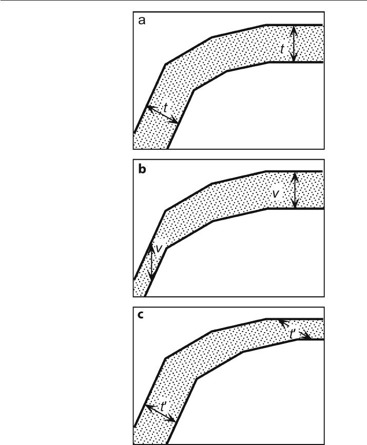
Folding may produce thickness changes that are a function of position within the
fold and the mechanical stratigraphy. Equation 3.1 is based on the assumption that
Fig. 3.21.
Cross sections showing direc-
tions of constant thickness.
The dips are identical in each
cross section. a Constant bed
thickness (t). b Constant verti-
cal thickness (v). c Constant
apparent thickness (t') in an
inclined direction
3.6 · Adding Information to the Data Base
82 Chapter 3 · Structure Contouring
bed thickness remains constant throughout the fold for all units being projected
(Fig. 3.21a), in other words, that all the horizons are parallel. This is called parallel
folding, and is only one of the possible fold styles. Deformation can change the thick-
nesses, especially the thicknesses of thick soft units between stiffer units. The direc-
tion of constant thickness is an element of the fold style. A similar fold maintains
constant thickness parallel to the axial surfaces. Constant vertical thickness projec-
tion (Handley 1954; Banks 1993) is strictly appropriate only for similar folds that have
vertical axial surfaces (Fig. 3.21b). The resulting thinning on steep limbs is a common
feature of compressional folds, even in those that maintain constant bed thickness
elsewhere. If the axial surfaces of a similar fold are inclined, the direction of constant
thickness is inclined to the vertical (Fig. 3.21c). Projection of surfaces is probably
best restricted to situations in which bed thicknesses are approximately constant
(Fig. 3.21a).
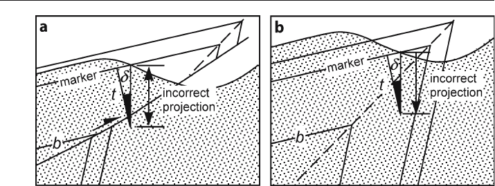
Projection of thickness is based on the further assumption that the stratigraphy
between the projection point and the composite surface is an unbroken sequence of
uniform dip. If the vertical line of projection crosses a fault (Fig. 3.22a) or an axial
surface (Fig. 3.22b), then the projection will be incorrect. The shorter the projection
distance, the less likely these problems are to occur.
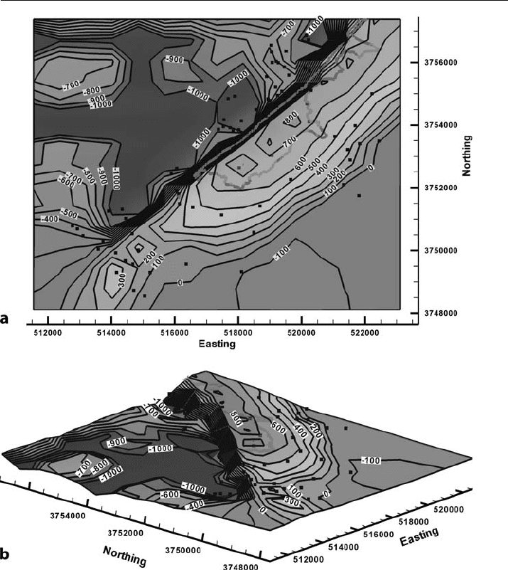
The value of a composite
-surface map in structural interpretation is shown by the
composite surface of the Mtfp (Fig. 3.23) in the Blount Springs map area. The pro-
jected points allow a structure contour map to be constructed for the top of a centrally
located stratigraphic horizon (top Mtfp). This map was produced by first interpolating
the dip values between control points and then projecting all the points on each con-
tact to the top of the Mtfp. Projecting using very steep dips provided some unrealistic
results because the long vertical projection distances cross gently dipping axial sur-
faces, invalidating the result as in Fig. 3.22b. The obviously incorrectly projected points
have been removed. The square points in Fig. 3.23a are the locations of dip measure-
ments and approximately indicate the limits of control. The complex structure north-
west of the anticline and the flat surface to the southeast are artifacts of the contouring
process (kriging) and do not represent real structure.
Fig. 3.22. Vertical cross sections showing incorrect projections across discontinuities. a Projection across
a fault. b Projection across an axial surface. The region below ground level is patterned.
δ
: dip; t: thickness
of the interval being projected
83
The major northeast-southwest trending structure (Fig. 3.23) is the Sequatchie anti-
cline, now clearly shown to be an asymmetric anticline with a steep forelimb on the north-
west. The internal consistency of the data appears to be good, confirming the general vali-
dity of all the mapped outcrop traces. The flattening and spreading of the anticline at its
southwest end is real, and represents a saddle where the fold crest steps to the northwest.
Fig. 3.23. Composite-surface map of the top Mtfp, Blount Springs map area of Fig. 2.4. The outcrop trace
of the top Mtfp is a wide, light gray line. Thicknesses used for projection are: Mpm = 108 ft and Mh = 105 ft,
calculated from the geologic map (Fig. 2.4); Mtfp = 245 ft from a well in the area; Mb = 625 ft from the
outcrop just southeast of the map area. Map coordinates are UTM in meters and contour elevations are in
feet. Squares are locations of dip measurements. a Map. b Oblique 3-D view to the northeast
3.6 · Adding Information to the Data Base
84 Chapter 3 · Structure Contouring
3.6.3
Fluid
-Flow Barriers
Fluid movement, or the lack of it, through porous and permeable units can indicate the
connectivity or the lack of connectivity between wells. A show is a trace of hydrocar-
bons in a well, and can indicate the presence of a nearby hydrocarbon trap that is
otherwise unseen. Different water levels, oil
-water contacts, or fluid pressures in nearby
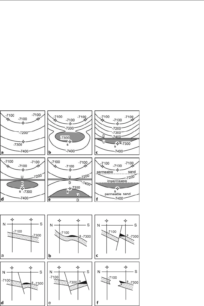
wells can indicate a barrier between the wells. The structure contour map in Fig. 3.24a
and the corresponding cross section in Fig. 3.25a show four wells that appear to define
a region of uniform dip. Suppose, however, that an oil or gas show is present in the
downdip well but not in the updip wells. The show suggests proximity to a hydrocar-
bon trap, yet the map does not indicate a trap. The map must be revised to include
some form of barrier because of this additional information (Sebring 1958). Possible
alternatives that could produce an oil or gas show in the downdip well include a hydro-
Fig. 3.24.
Alternative maps honoring the
same data points. a Map based
on the four wells being dry
holes. b–f Maps based on pres-
ence of an oil show in the well
labeled s, implying presence of
a barrier between this well and
the three updip dry holes. Hy-
drocarbon accumulations are
shaded. Figure 3.25 shows the
corresponding cross sections.
(After Sebring 1958)
Fig. 3.25.
Alternative cross sections in
the dip direction honoring the
same data points. a Section
based on the four wells being
dry holes. b–f Sections based
on presence of an oil show (s)
in the downdip well, implying
a barrier between this well and
the updip wells. Hydrocarbon
accumulations are shaded.
Figure 3.24 shows the corre-
sponding structure contour
maps. (After Sebring 1958)
85
carbon-filled structural closure up the dip (Figs. 3.24b, 3.25b), different types of faults
between the downdip well and the updip wells (Figs. 3.24c–e, 3.25c–e) or a stratigraphic
permeability barrier (Figs. 3.24f, 3.25f). A stratigraphic barrier does not necessarily
require the structure to be changed from the original interpretation. The structural
configuration is the same in Figs. 3.24f and 3.25f as in Figs. 3.24a and 3.25a.
3.7
Exercises
3.7.1
Contouring Styles
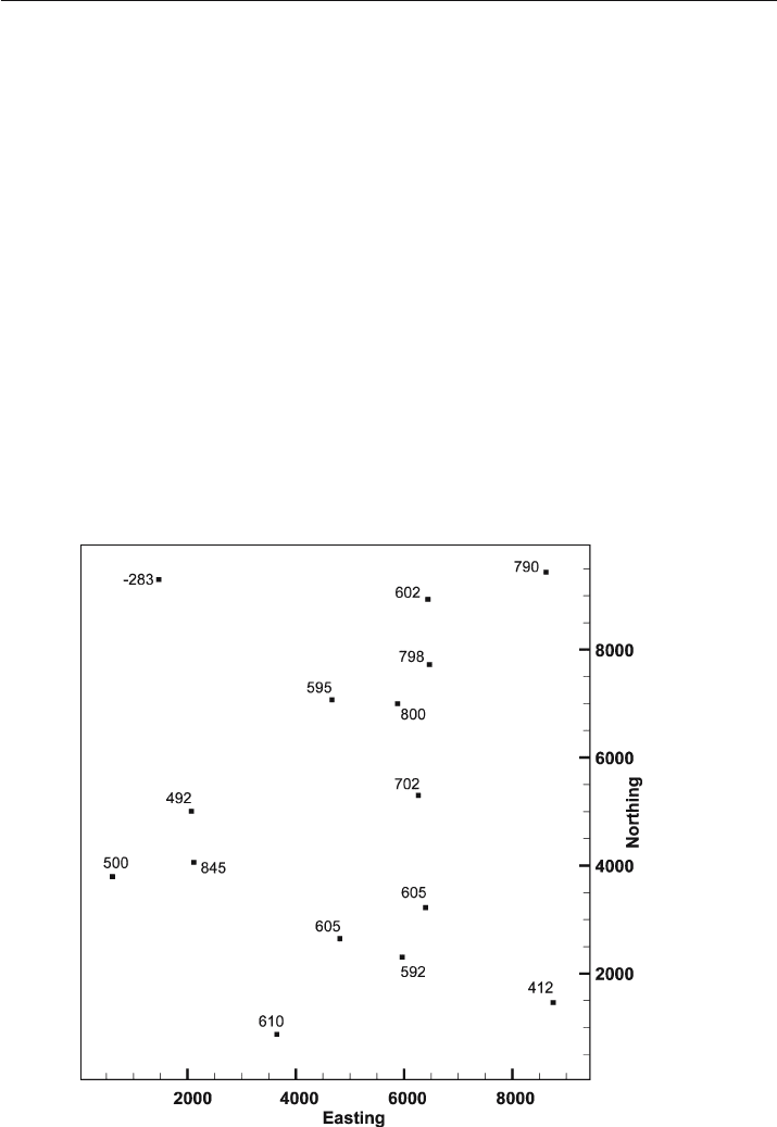
Use the data from the Weasel Roost Formation (Fig. 3.26) to try out different contour-
ing techniques and to see the effect of trend biasing. Use interpretive contouring and
assume a surface with no grain. Contour by parallel contouring: (a) assuming a north-
west-southeast grain; (b) assuming a northeast-southwest grain. Draw crestal and
trough traces on the structure contour maps just completed. Use interpretive con-
touring and assume a northeast
-southwest grain. Define a TIN using greedy triangu-
lation and contour by linear interpolation.
Fig. 3.26. Map of elevations (feet or meters) of the top of the Weasel Roost Formation
3.7 · Exercises
86 Chapter 3 · Structure Contouring
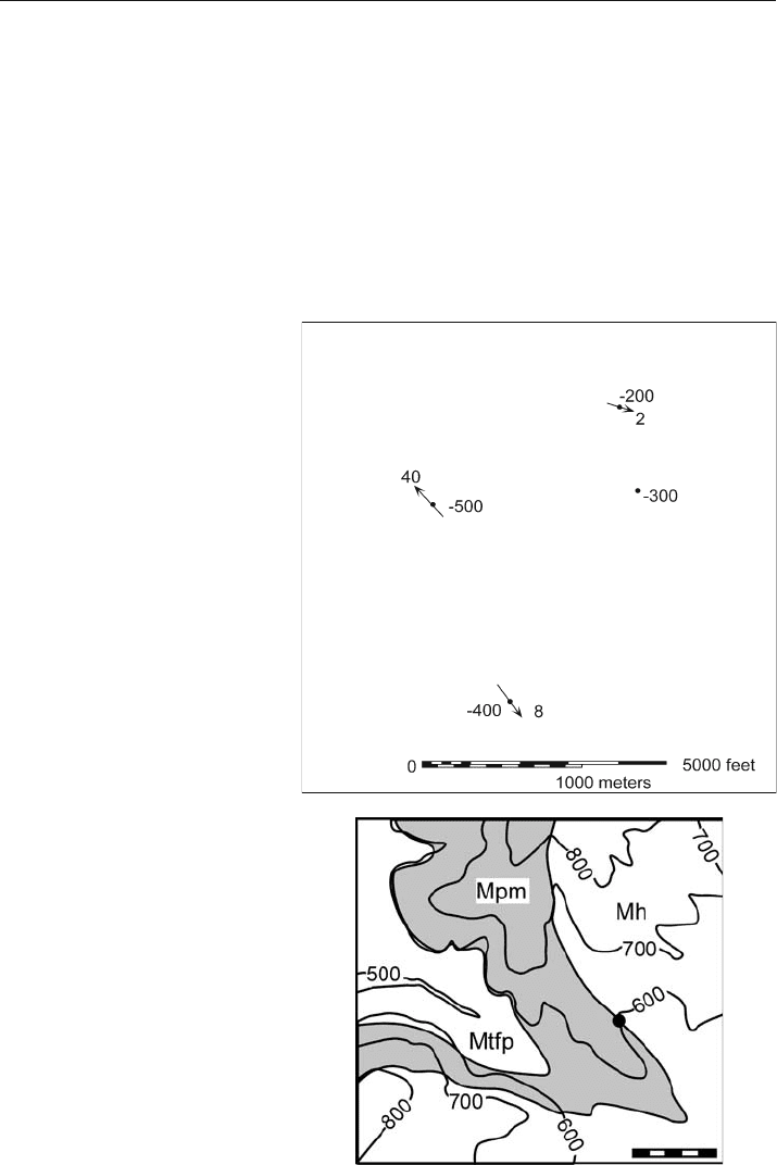
Fig. 3.27.
Map of the top of the porous
Tuscaloosa sandstone. Nega-
tive elevations are below sea
level; azimuth of bedding dip
is indicated by arrows
Fig. 3.28.
Geologic map of the Mill Creek
area. Topographic elevations
are in feet and the scale bar
is 1000 ft
3.7.2
Contour Map from Dip and Elevation
Contour the top of the Tuscaloosa sandstone in Fig. 3.27 using the bedding attitudes to
help generate the contour orientations and spacings. The elevations are in meters.
3.7.3
Depth to Contact
Find the elevation of the top of the Mtfp below the dot in Fig. 3.28. The thickness of
the Mpm is 97 ft and the dip is 04°.
