Groshong Richard H. 3-D Structural Geology(Second Edition)
Подождите немного. Документ загружается.

46 Chapter 2 · Location and Attitude
Plotting poles and lines can be done more quickly on a stereogram using a
Biemsderfer plotter (Wise 2005), a calibrated dip scale that rotates on the center of the
net to allow plotting of points without rotating the overlay. The attitudes of lines such
as dip vectors and lineations are also quickly and easily plotted on a tangent diagram,
described in Sect. 2.3.3.
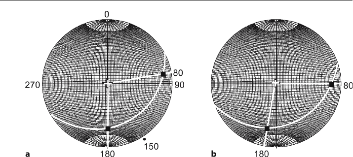
Apparent dips are quickly determined on a stereogram as the orientation of the
point of intersection between a line in the direction of the apparent dip and the great-
circle trace of a plane. For example, find the apparent dips along the azimuths 080
and 180 for the plane plotted previously (
δδ
δδ
δ
= 32, 150). Plot lines from the center of the
graph in the azimuth directions (Fig. 2.15a). The intersections of the azimuth lines
with the great circle are the apparent dips. Dips can be read from the N-S axis as well
as the E
-W and so the 180° azimuth is in measurement direction. The angle measured
inward from the primitive circle to the intersection is the apparent dip, 28°. The over-
lay is rotated into measurement position for the 080° azimuth (Fig. 2.15b) to find the
apparent dip of 15°.
Apparent dip problems can be worked backwards to find the true dip from two
apparent dips. Plot the points representing the apparent dips, then rotate the overlay
until both points fall on the same great circle. This great circle is the true dip plane.
2.3.2
Natural Variation of Dip and Measurement Error
The effect of measurement error or of the natural irregularity of the measured surface
on the determination of the attitude of a plane is readily visualized on a stereogram.
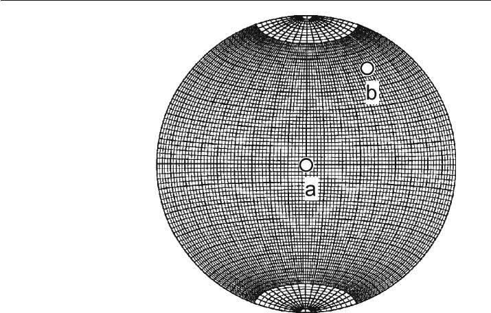
The plane is represented by its pole (Fig. 2.16). Irregularities of the measured surface
and measurement errors should produce a circular distribution of error around this
pole (Cruden and Charlesworth 1976). An error of 4° around the true dip is probably
Fig. 2.15. Apparent dip in the plane given by the dip vector 32, 150 on an equal-area, lower-hemisphere
stereogram. a Plane plotted with apparent dips shown as black squares. The south
-trending apparent
dip is 28, 180. b Overlay rotated 10° to bring the 080° trending apparent dip into measurement posi-
tion; apparent dip is 15, 080
47
the maximum expected for routine field measurements on a normally smooth bed
surface. Measurements on a rough surface may show an even greater variability. A
good average attitude from a rough surface can be obtained by making several mea-
surements and then separately averaging the strikes and dips or the trends and plunges
of the dips. A good field measurement procedure is to lie a flat field notebook or square
of rigid plastic on a rough bed surface to average out the irregularities.
The effect of the error is related to the attitude of the plane. If the bed is horizontal,
the pole is vertical (Fig. 2.16, point a) and the error means that the azimuth of the dip
could be in any direction, even though the true three
-dimensional orientation of the plane
is rather well constrained. Small irregularities on a bed surface have the same effect
(Woodcock 1976; Ragan 1985). On a steeply dipping plane (Fig. 2.16, point b), the same
amount of error causes little variation in either the azimuth or the dip. Conversely, the
measurement of the trend of a line on a gently dipping surface is accurate to within a
few degrees, but the direction measured on a steeply dipping plane may show signifi-
cantly greater error (Woodcock 1976). A precision of about 2° is about normal for
calculations done using a stereogram. For greater precision, the calculations should be
done analytically by methods that will be presented later in the chapter.
2.3.3
Tangent Diagram
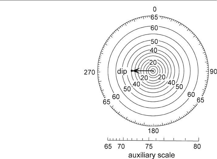
The other useful diagram for representing the attitudes of planes is the tangent dia-
gram (Fig. 2.17; an enlarged copy is given at the end of the chapter as Fig. 2.29). De-
veloped by Hubbert (1931), it has been popularized by Bengtson (1980, 1981a,b) in
the context of dipmeter interpretation. It is particularly valuable in the determina-
Fig. 2.16.
Equal
-area, lower-hemisphere
stereogram. Measurement
error of 4° (radius of circles)
around true bedding poles
(points a and b)
2.3 · Orientations of Lines and Planes
48 Chapter 2 · Location and Attitude
tion of the crest lines of cylindrical and conical folds (Chap. 5). The concentric circles
on the diagram represent the dip magnitude and their spacing is proportional to the
tangent of the dip, hence the name tangent diagram. The center of the diagram is
zero dip. The azimuth is marked around the margin of the outer circle. The attitude
of a plane is represented by a vector from the origin in the direction of the azimuth
and having a length equal to the dip amount (Fig. 2.17). The attitude can be shown
with the complete vector or as a point plotted at the location of the tip of the vector.
See Sect. 2.8 for how to plot dip vector points on a tangent diagram using a spread-
sheet. A major convenience of the tangent diagram is that no overlay is required and
that certain problems are solved very quickly and without the rotations that are re-
quired with the stereogram. The drawback of the tangent diagram is that very steep
dips require a very large diagram. The diagram in Fig. 2.17 extends to a dip of 65°. A
calibrated scale that can be used to plot dips from 65° to 80° is given at the bottom of
this figure. To use it, plot the vector along the appropriate radius and use the auxil-
iary scale to find the added length of the vector beyond the outer circle of the dia-
gram. The diagram is not practical if a significant percentage of the dips are over 70°,
for which a stereogram is more suitable. The tangent diagram can be used as a circu-
lar histogram, even for steep dips, by plotting the steep dips with their correct azi-
muths along the outer circle.
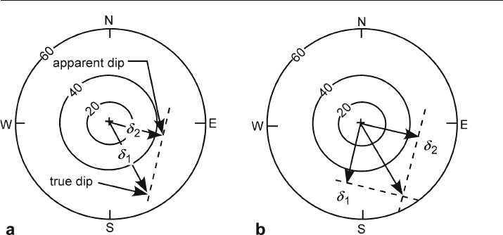
A tangent diagram is a convenient tool for finding the true or apparent dip. The
apparent dip in a given direction (Fig. 2.18a) is the vector in the appropriate direction.
Fig. 2.17.
Tangent diagram. Arrow rep-
resents a plane dipping 40°
to the west (40, 270). (After
Bengtson 1980)
49
For example, given a dip vector of a bed
δδ
δδ
δ
1
, find the apparent dip in the direction of
δδ
δδ
δ
2
.
Project the tip of
δδ
δδ
δ
2
onto the direction of
δδ
δδ
δ
1
. The projection is along a line perpendicu-
lar to the apparent dip. The length of the projected bedding vector in the direction of
the apparent dip is the amount of the apparent dip. The true dip can be found from
two apparent dips. The perpendiculars from the apparent dips (
δδ
δδ
δ
1
and
δδ
δδ
δ
2
) intersect at
the tip of the true dip vector (Fig. 2.18b).
2.4
Finding the Orientations of Planes
The attitude of a plane measured by hand with a compass or given by a dipmeter log
is effectively the value at a single point. Measured over such a small area, the attitude
is very sensitive to small measurement errors, surface irregularities, and the presence
of small
-scale structures. The following two sections describe how to find the attitude
from three points that can be widely separated and from structure contours. Both
methods provide an average attitude representative of the map
-scale structure.
The farther the points depart from a straight line, the more reliable the expected
result because small irregularities or location errors will have less influence on the
result. If more than three points are available to find the attitude of the plane, a best
-
fit can be determined using planar regression or moment of inertia analysis (Fernández
2005). A typical situation for this application would be a series of points along the
outcrop trace of a plane (e.g., Fig. 2.4). On the other hand, the farther the points are
from one another, the greater the possibility that they no longer fall on a single plane.
A high
-quality calculated dip will be compatible with the surrounding data as demon-
strated with a structure contour map (Chap. 3) and cross section (Chap. 6). If the unit
thickness is known (Chap. 4), a very powerful test of the quality of a calculated dip is
to show that both the top and base of the unit fit their respective outcrop traces.
Fig. 2.18. Apparent dip on a tangent diagram. a Apparent dip from true dip. b True dip from two ap-
parent dips. (After Bengtson 1980)
2.4 · Finding the Orientations of Planes
50 Chapter 2 · Location and Attitude
2.4.1
Graphical Three
-Point Problem
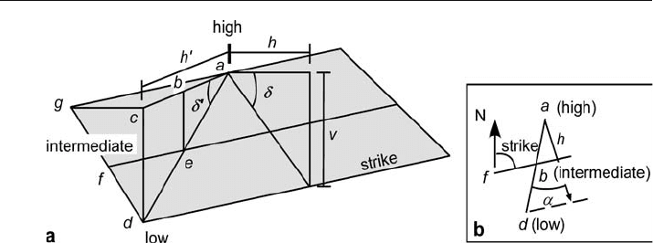
The attitude of a plane can be uniquely determined from three points that are not on
a straight line. Let the highest elevation be point a and the lowest be point d (Fig. 2.19).
The intermediate elevation, f, must also occur along the line joining a and d as point e.
The line fe is the strike line. The horizontal (map) distance from a to e by linear
interploation is ab, where
ab = (ac × be) / cd . (2.10)
Plot the length ab on the map (Fig. 2.19b) and join point f and b to obtain the strike
line. The dip vector lies along the perpendicular to the strike, directed from the high
point to the intermediate elevation along the strike line. The dip amount is
δ
=arctan(v / h) , (2.11)
where v = the elevation difference between the highest and the lowest points and h =the
horizontal (map) distance between the highest point and a strike
-parallel line through d.
The azimuth of the dip is measured directly from the map direction of the dip.
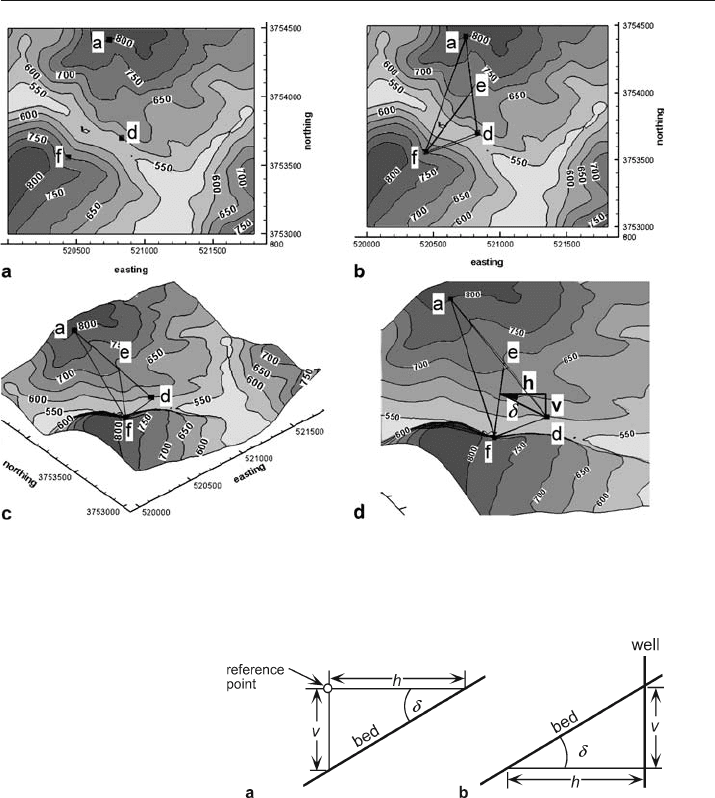
A typical example of a 3-point problem is seen on the map of Fig. 2.20a. The map
shows the elevations of three locations identified in the field as being on the same
contact (a, f, d). These points could just as easily be the elevations of a formation bound-
ary identified in three wells. To find the attitude of the contact, draw a line between the
highest and lowest points (a–d, Fig. 2.20b) and measure its length. Use Eq. 2.10 to find the
distance along the line from the high point to the level of the intermediate elevation (e).
Connect the two intermediate elevations to find the strike line (Fig. 2.20b,c). Draw a
perpendicular from the strike line (e–f) to the lowest point (d, Fig. 2.20d). The hori-
zontal length of the line is h and the elevation change is v. Determine the dip from
Eq. 2.11. The azimuth of the dip is measured from the map. The dip vector in this
example is 22, 125.
Fig. 2.19. True dip,
δ
, and apparent dip,
δ
'. a Perspective view. b Map view. N: north. For explanation
of a–h and v, see text
51
A dip can be converted from degrees into feet/mile or meter/kilometer by solving Eq. 2.11
for v and letting h be the reference length (5 280 ft for ft/mile or 1 000 m for m/km):
v = h tan
δ
, (2.12)
where v = the vertical elevation change, h = reference length, and
δ
= dip. The same
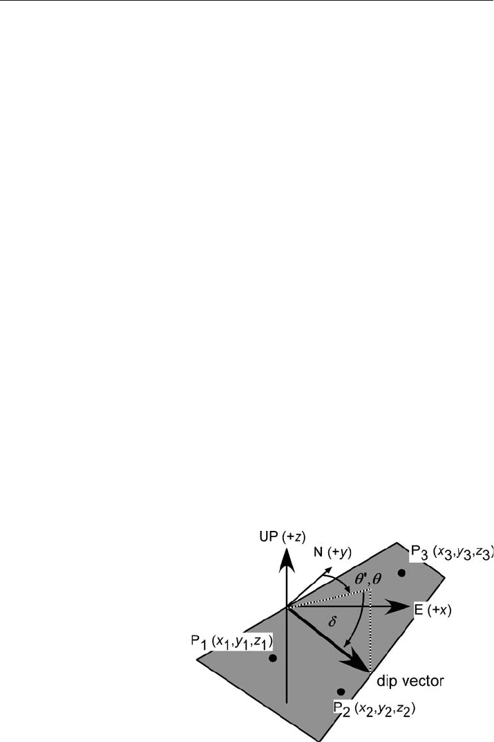
relationship can be used to determine the vertical distance from a reference point to
a dipping horizon seen in a nearby outcrop (Fig. 2.21a).
Another useful application of Eq. 2.11 is to find the distance to the intersection be-
tween a horizontal plane (such as an oil
-water contact) and a dipping plane (such as
Fig. 2.20. Attitude determination from three points on a topographic map. Horizontal scale in km, ver-
tical scale in ft. a Three points (solid squares) on a contact. b Determination of the strike line (e–f).
c The same three points in oblique 3
-D view to NE. d Enlarged 3-D view of three-point solution
Fig. 2.21.
Distance to a point on a dip-
ping bed, in vertical cross
sections in the dip direction.
a Vertical distance from a ref-
erence point to a dipping bed.
b Horizontal distance from a
well to a dipping bed
2.4 · Finding the Orientations of Planes
52 Chapter 2 · Location and Attitude
the top of the unit containing the contact) which are separated by a known distance in
the well. Solve Eq. 2.11 for h (Fig. 2.21b):
h = v /tan
δ
, (2.13)
where h = distance from the well bore to the intersection with a dipping bed and
v = vertical distance in the well between the intersection of the dipping horizon and
the horizontal horizon.
2.4.2
Analytical Three
-Point Problem
The attitude of a plane is given by the trend and plunge of the dip vector (Fig. 2.22). The
dip vector can be determined analytically from the xyz coordinates of three non
-colinear
points (derived in Sect. 12.3). The preliminary trend and plunge of the dip vector is
θ
'=arctan(A / B) , (2.14)
δ
= arcsin {–cos [90 + arccos (C / E)]} , (2.15)
where
θ
' = the preliminary azimuth of the dip,
δ
= the amount of the dip, and
A = y
1
z
2
+ z
1
y
3
+ y
2
z
3
– z
2
y
3
– z
3
y
1
– z
1
y
2
, (2.16a)
B = z
2
x
3
+ z
3
x
1
+ z
1
x
2
– x
1
z
2
– z
1
x
3
– x
2
z
3
, (2.16b)
C = x
1
y
2
+ y
1
x
3
+ x
2
y
3
– y
2
x
3
– y
3
x
1
– y
1
x
2
, (2.16c)
D = z
1
y
2
x
3
+ z
2
y
3
x
1
+ z
3
y
1
x
2
– x
1
y
2
z
3
– y
1
z
2
x
3
– z
1
x
2
y
3
, (2.16d)
E =(A
2
+ B
2
+ C
2
)
1/2
. (2.16e)
Fig. 2.22.
Three points on a plane and
the dip vector of the plane
53
The sign of E =–signD if D ≠ 0; = sign C if D =0 and C ≠ 0; = sign B if C = D =0.
Division by zero is not allowed in Eq. 2.14. The value of
θ
' computed from Eq. 2.7 is
always between the values of 000° and 090° and is equal to 90° if B = 0. The true
azimuth,
θ
, of the dip in the complete range from 000° to 360° can be determined from
θ
'
and the signs of cos
α
and cos
β
(Eqs. 2.17 and Table 2.1):
cos
α
= A/ E , (2.17a)
cos
β
= B / E , (2.17b)
where A, B, and E are given by Eqs. 2.16a,b,e above.
As an example, find the analytical solution to the 3
-point problem in Fig. 2.20. The
three points have the coordinates, in xyz order, of 520 739, 3 754 420, 800; 520 438,
3 753 560, 700; 520 833, 3753 700, 600. From Eqs. 2.14–2.17, the dip is 22° at an azimuth
of 125°. The leading UTM digits of the x and y coordinates are identical and need not
be included in the calculation.
2.5
Apparent Dip
Apparent dip,
δ
', is the angle in a plane between the horizontal and some direction
other than the true dip (Fig. 2.19a). To find the apparent dip, let the horizontal angle
between the true and apparent dip be
α
, then
δ
' = arctan (tan
δ
cos
α
) . (2.18)
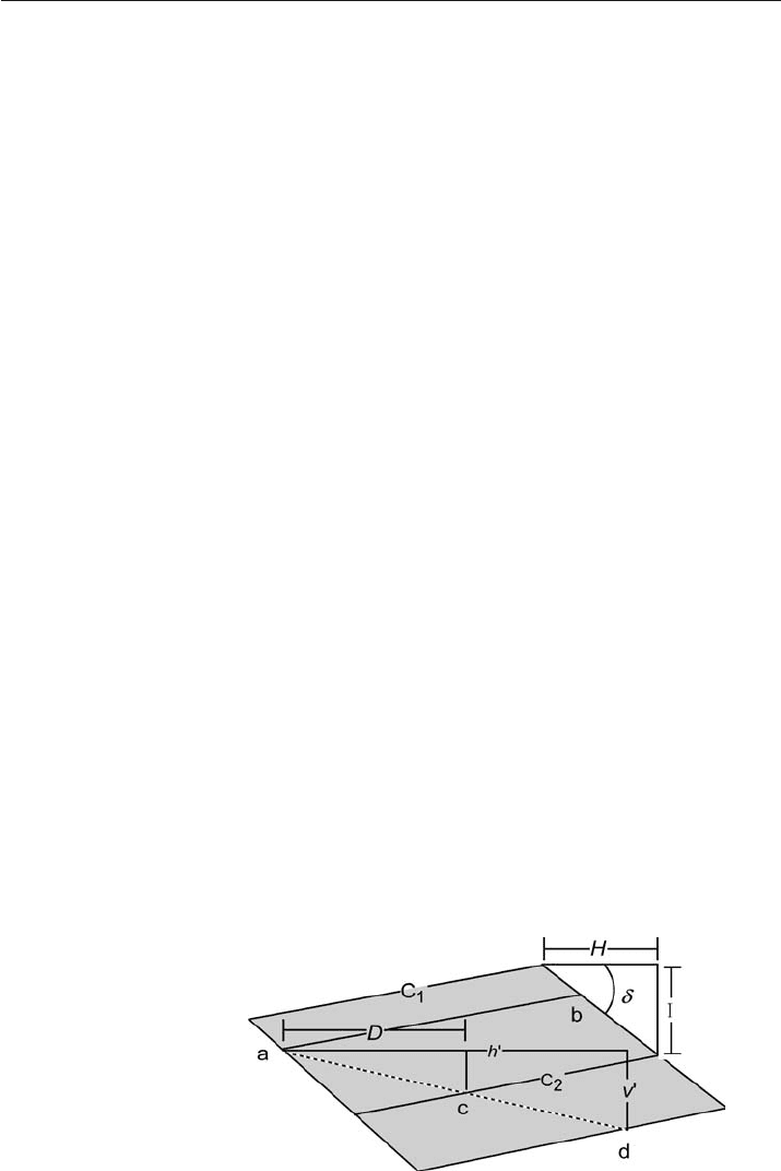
On a completed structure-contour map, the apparent dip in a given direction is found
from
δ
'=arctan(I / h') , (2.19)
where I = the contour interval and h' = the horizontal distance on the map between
the contours in the direction of interest (Fig. 2.23). If the direction perpendicular to
the contours is selected, then the apparent dip is the true dip. If the strike direction is
selected, the apparent dip is zero.
Fig. 2.23.
Relationships between struc-
ture contours, point elevations,
and dip. Points a and b are at
the same elevation; c and d are
at different elevations. C
1
and
C
2
are structure contours. For
explanation of other symbols,
see text
2.5 · Apparent Dip
54 Chapter 2 · Location and Attitude
2.6
Structure Contours
Structure contours provide an efficient and effective representation of the attitude of a
surface. The contours are strike lines and the dip direction is perpendicular to the con-
tours (Fig. 2.23). The simplest way to construct structure contours from a geologic map
is to connect points on a contact that lie at the same elevation. If two points on a contact
have the same elevation, for example a and b in Fig. 2.23, then a line joining them is a
strike line or structure contour. Finished maps normally show contours at even incre-
ments of elevation.
Structure contours are the primary method for illustrating the shape of structures in the
subsurface. Generated from outcrop maps, structure contours provide an effective method
for validating the outcrop pattern and for smoothing out local dip variations caused by bed
roughness. If a map horizon is planar, the contours on it are parallel and uniformly spaced.
Folding produces curved contours that usually are not far from parallel at a local scale.
Abrupt changes in direction indicate fold hinges, faults, or mistakes. Unless radical thickness
changes occur, the structure contours on adjacent horizons are approximately parallel.
The following sections describe the creation of straight
-line structure contours from
the elevations of three points and the interpretation of contours in the vicinity of a dip
measurement. The generation of curved structure contours from multiple control points
is discussed in Chap. 3.
2.6.1
Structure Contours from Point Elevations
Structure contours are usually generated from point elevations, especially in subsur-
face work. Except for the unlikely circumstance where all the points happen to fall on
the selected contour elevations, contouring will require placing contours between con-
trol points that have different elevations. This means that contour values must
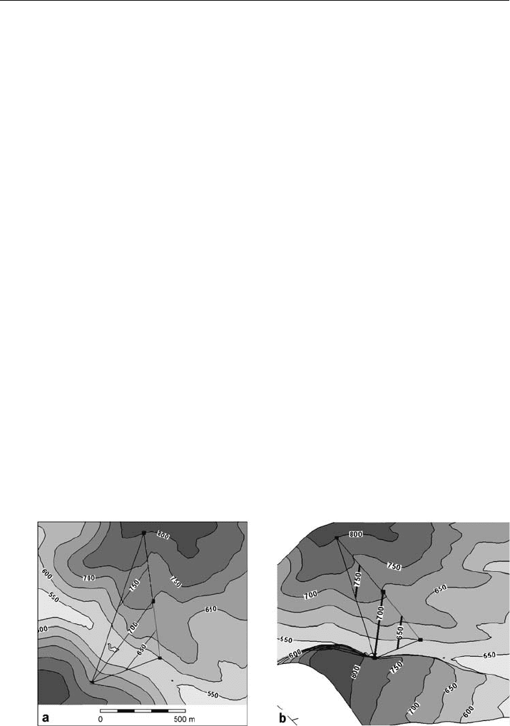
Fig. 2.24. Structure contours on a dipping plane (from Fig. 2.20). The 650-ft and 750-ft contours are
interpolated between the four control points. a Plan view. b 3
-D oblique view to NE

55
be interpolated between the control points. Using linear interpolation (more complex
forms of interpolation are considered in Chap. 3), an interpolated even
-elevation con-
tour lies at point c (Fig. 2.23) on the straight line between the two points at known
elevations a and d. Following the method of Eq. 2.10, the elevation of the upper control
point is a, the horizontal distance of the desired contour from the highest control point
is D, the elevation of the desired contour is C
2
, the map distance between the two control
points is h', and the vertical distance between the two control points is v', giving
D = h' (a – C
2
)/v' . (2.20)
As an example, the strike line constructed in Fig. 2.20b is itself a structure contour
line. Two additional structure contour lines are shown in Fig. 2.24.
2.6.2
Structure Contours from Attitude
If the dip is known, then the spacing between structure contours is found from the
method of Eq. 2.11 (Fig. 2.23) to be
H = I /tan
δ
, (2.21)
where H = horizontal spacing between structure contours measured perpendicular to
the contour strike, I = contour interval, and
δ
= dip. The trend of the structure con-
tours is perpendicular to the dip direction.
2.6.3
Dip from Structure Contours
If the attitude is given by structure contours, the dip is found by solving Eq. 2.21:
tan
δ
= I / H , (2.22)
where
δ
= dip, I = contour interval, and H = spacing between contours. The dip direc-
tion is perpendicular to the contour, in the direction toward the lower contour.
2.7
Intersecting Contoured Surfaces
The trace of a contact on a geologic map represents the intersection of the topographic
surface with the boundaries of the geologic units. Finding the intersection between two
surfaces is a fundamental technique in three
-dimensional interpretation. In Sect. 2.6.1,
three points along the outcrop trace of a planar geological contact were used to gen-
erate a structure-contour map. Conversely, the outcrop trace of a contact can be deter-
mined from a structure contour map. The following procedure works for both plane
and curved structure contour surfaces. The structure contour map is superimposed
on the topographic map (Fig. 2.25a). All intersection points where both surfaces have
2.7 · Intersecting Contoured Surfaces
