Groshong Richard H. 3-D Structural Geology(Second Edition)
Подождите немного. Документ загружается.

280 Chapter 9 · Dip-Sequence Analysis
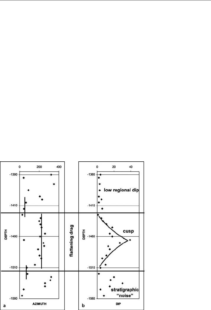
Interpretation begins with the azimuth-depth and dip-depth plots (Fig. 9.23). At shal-
lower elevations in the well, the dip magnitude is consistently low and the azimuth highly
variable. These are the characteristics expected for a low regional dip (c.f., Fig. 9.9). The
next deeper interval appears to be a cusp on the dip
-depth diagram. In the context of a
cusp, the azimuth
-depth diagram suggests flattening drag (c.f., Fig. 9.18). The lower por-
tion of the well contains no clear structural pattern and may represent stratigraphic noise,
perhaps a unit containing disparate dips like a conglomerate (where the pebble bound-
aries would produce dip readings) or a reef (where individual corals might be producing
the dips).
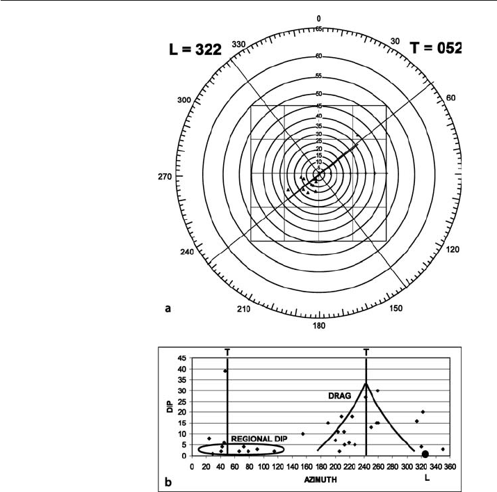
Having isolated the cusp as an interval of interest, further analysis will be performed
on that part of the well log alone. The T and L directions are most clearly found on the
tangent diagram (Fig. 9.24a). There is a substantial amount of scatter but the least squares
best
-fit line does a good job of locating the T direction. Where it can be checked against
other geological data, the best fit line has proved to be remarkably reliable, even where the
scatter is large. If a quadratic best
-fit line approximates a hyperbola and fits the data
reasonably well, then the fold is probably conical. Where a quadratic best
-fit is not hyper-
bolic, the best fit is linear and the fold is cylindrical. The dip
-azimuth diagram (Fig. 9.24b)
shows substantial scatter but can be interpreted with reference to Fig. 9.18 as showing a
regional dip component and a drag-fold component. The results of this stage of the analy-
sis give T = 052 and L = 322. Additional valuable information is the strike of the fault,
which must be approximately parallel to the L direction, 322°.
Fig. 9.23.
Azimuth-depth and dip-depth
diagrams for data in Table 9.2.
a Azimuth versus depth. b Dip
versus depth
281
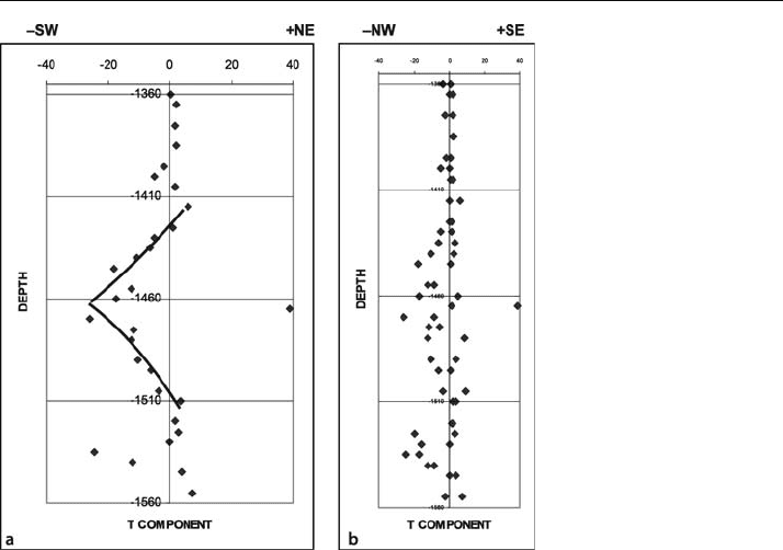
The final part of the interpretation is based on the T and L component plots. A
normal fault dips in the direction the cusp points on a T component plot, which is to
the southwest for this example (Fig. 9.25a). At this stage, the effect of the choice of the
T and L directions on the component plots should be examined. Vary their directions
and watch for the effect on the L
-component plot. The best result is one which shows
the points falling the closest to the zero line, indicating that the L direction has been
correctly chosen. The result in Fig. 9.25b is the best that can be obtained from this data
set. Note that the data point that was at the tip of the cusp on the dip
-depth plot
(Fig. 9.23b) lies on the wrong (NE) side of the T
-component plot (Fig. 9.25a). Re-ex-
amination of the original data (Fig. 9.22) shows this to be a point with poor data qual-
ity. It might represent a dip on a fracture or be a spurious result on fractured rock in
the fault zone. No data at all might be expected from a fault zone in which the bedding
has been highly disrupted by the deformation.
Fig. 9.24.
Determination of T and L di-
rections for data in Table 9.2.
a Tangent diagram. b Dip-
azimuth diagram
9.6 · Analysis of Faults
282 Chapter 9 · Dip-Sequence Analysis
9.7
Exercises
9.7.1
SCAT Analysis of the Sequatchie Anticline
Use the data in Table 9.1 to perform a complete SCAT analysis on the dip traverse across
the Sequatchie anticline. Plot the azimuth-distance and the dip-distance diagrams. What
are the T and L directions? What are the dip components in the T and L directions?
Plot them on the dip
-component diagrams.
9.7.2
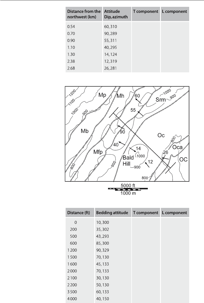
SCAT Analysis of Bald Hill Structure
Use the data in Table 9.3 to perform a complete SCAT analysis on the dip traverse across
the Bald Hill structure to see if a fault is present and its location and orientation, given
that the faults in the area are reverse.
9.7.3
SCAT Analysis of Greasy Cove Anticline
Perform a complete SCAT analysis on the Greasy Cove anticline (Table 9.4). Consider both
fold and fault geometry. The anticline is part of the southern Appalachian fold
-thrust belt.
Fig. 9.25.
T and L component plots for
data in Table 9.2, given T = 052
and L = 322. Plus and minus
values assigned to the compass
directions are for spreadsheet
plotting purposes. a T compo-
nent versus depth. b L compo-
nent versus depth
283
Fig. 9.26.
Geologic map of the Bald Hill
area. Topographic contours (in
feet) are thin lines; geologic
contacts are wide gray lines.
Data have been projected par-
allel to strike onto NW-SE
traverse line. (Modified from
Burchard and Andrews 1947)
Table 9.3.
Bald Hill bedding attitudes
Table 9.4.
Southeastern Greasy Cove
anticline bedding attitudes
9.7 · Exercises

Chapter 10
10.1
Introduction
This chapter focuses on the quality control of completed interpretations as expressed in
maps and cross sections. Quality control means locating and correcting errors in the data
and in the interpretation. Problems can arise from data transcription errors, incomplete
exposure in the field, interpolation uncertainties between wells and seismic profiles, and
missing or misleading information in seismic interpretations. The quality
-control issues
discussed in this chapter can be broadly categorized as data errors and contouring arti-
facts, inconsistency of trends, bed thickness anomalies, and impossible fault shapes.
Additional techniques for detecting and correcting errors involving the restoration and
balancing of cross sections are covered in Chap. 11. Those topics are covered separately
because they also include related methods for extracting additional geological informa-
tion from the data and for making model-based predictions of the geometry. The single
best quality control for an interpretation is to build an internally consistent, 3
-D model of
the entire structure. Many of the individual problems noted in the following sections would
be obvious in 3
-D. The following sections discuss methods that are commonly applied in
2
-D, that is, to geological outcrop maps, structure contour maps, and to cross sections.
10.2
Data Errors and Contouring Artifacts
Before a map is finalized, it should always be examined for data errors, edge effects,
and contouring artifacts. Some of these problems are nearly inevitable because of human
error in data input and the intrinsic behavior of computer contouring algorithms.
10.2.1
Data Errors
Data errors are a likely possibility where single points fall far from the average surface.
Problem points may be recognized by the presence of small closed highs or lows, usu-
ally defined by multiple contours that surround an individual point. Such errors com-
monly arise from mistakes in the interpretation of the unit boundaries or as transcription
errors in transferring data to the map. This type of error tends to produce very local
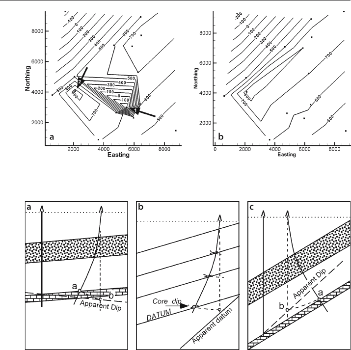
highs and lows on a preliminary structure contour map (Fig. 10.1a). Point 1 (Fig. 10.1a)
is almost certainly a bad data point as it forms a small, deep depression in the map
surface. Point 2 is a closure at an elevation consistent with other elevations on the map
Quality Control
286 Chapter 10 · Quality Control
and could be real or a bad data point. Removal of point 1 leads to a more structurally
reasonable map (Fig. 10.1b) and shows point 2 to be consistent with the revised map.
Maps produced by triangulation are the best for recognizing data errors because gridded
maps smooth the values and thereby reduce the effect of anomalous values. It is always
worth checking a point that produces a one
-point closure. Local closures, if actually
present, are important because, for example, they might form hydrocarbon traps.
Bad points can arise from a deviated well that is mistakenly interpreted as being ver-
tical, causing both location and thickness anomalies. The log depth to a formation boundary
is larger in a well that deviates down dip than in a vertical well at the same surface location
(Fig. 10.2a). If the formation boundary is plotted vertically beneath the well location, its
depth will be too great. If an apparent dip is then determined between this well and a
Fig. 10.1. Locating data errors on a structure contour map. a Preliminary map with questionable clo-
sures. b Map recontoured after removal of point 1
Fig. 10.2. False apparent dips caused by unrecognized well deviation. a Apparent dip determined between
two wells, one unknowingly deviated down dip. b Dip determined from core dip in the unknowingly devi-
ated well. c Apparent dip determined between two wells, one unknowingly deviated up dip. (After Low 1951)
287
correctly located formation top in another well, the apparent dip will be wrong, perhaps
even in the wrong direction (Fig. 10.2a). If the dip is determined from a core in a deviated
well (Fig. 10.2b) that is mistakenly thought to be vertical, then the inferred dip will be too
large. The apparent thicknesses are too large in both situations. A well that deviates up
dip will result in an apparent steepening of the dip between two wells and thicknesses (if
mistakenly corrected for dip) that will be too small (Fig. 10.2c).
10.2.2
Edge Effects
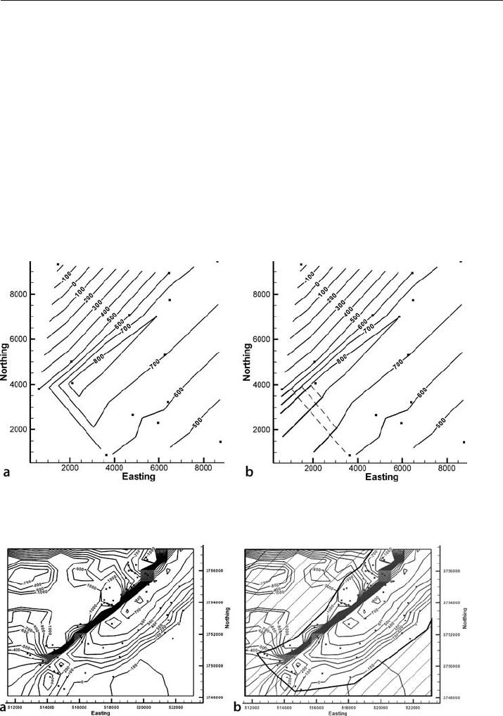
Both humans and computer-contouring algorithms appear to prefer contours that close
within the map area. In Fig. 10.3a, the triangulation algorithm has closed the contours
on southwest end of the anticline. Based on the available control, open contours to the
southwest (Fig. 10.3b) are equally valid and perhaps more geologically reasonable.
Fig. 10.3. Is the closure real? a Anticline closed to the southwest in triangulated map from data in Fig. 3.5.
b The same structure opened to the southwest (heavy lines), deleted contours dashed
Fig. 10.4. Edge effects on a map of the Sequatchie anticline. Control points are solid squares. a Map
from Fig. 3.23a. b Same map with region of no data shaded (diagonal lines)
10.2 · Data Errors and Contouring Artifacts
288 Chapter 10 · Quality Control
Gridding algorithms typically extend the contours to the edges of the grid, regard-
less of whether or not data are present to support the extrapolation. Figure 10.4a is a
map produced by a computer kriging algorithm over a rectangular region. The region
without any data to control the contours is shaded in Fig. 10.4b. The closed highs and
lows within the shaded area are completely spurious.
A TIN network may contain extremely elongated triangles along the edges of the
data, implying a relationship between widely separated points. Such widely separated
points are not necessarily geologically related and probably should not influence the
shape of the surface between them. The TIN network should be examined for such
problems and such long
-distance connections might be removed. Some computer
programs eliminate triangles for which one or two of the angles are smaller than a
threshold value. This tends to reduce the problem but does not eliminate it.
10.2.3
Excessive Detail
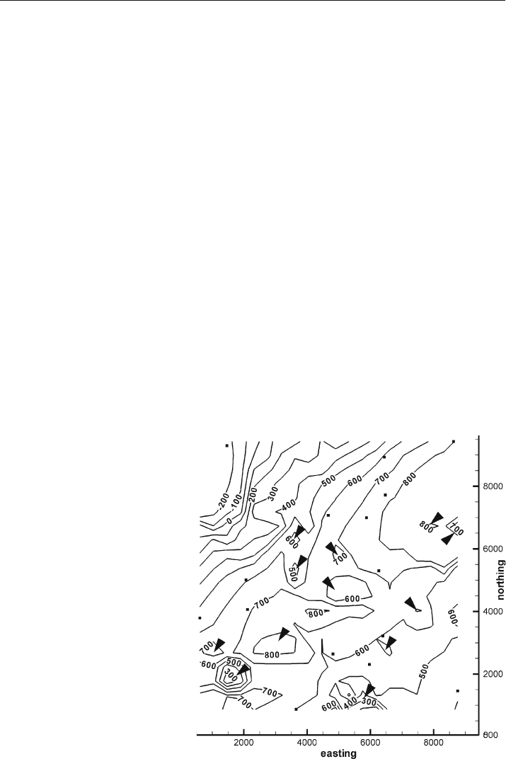
Excessively wiggly contours or areas containing multiple, small, structural closures may
be contouring artifacts (Krajeweski and Gibbs 1994). Closed contours that do not con-
tain control points should be viewed with suspicion as artifacts of the gridding algo-
rithm (Fig. 10.5). This type of artifact only occurs with gridding algorithms and is
more likely when using high
-order surfaces (e.g., kriging with quadratic drift and grid-
node densities much greater than the control-point density).
Another type of artifact may arise if data from multiple sources, such as different
seismic surveys, are contoured together, because their datums may be different. Each
Fig. 10.5.
Structure contour map from
Fig. 3.11d. Control points are
small squares. Triangles point
to local closures unjustified by
control points
289
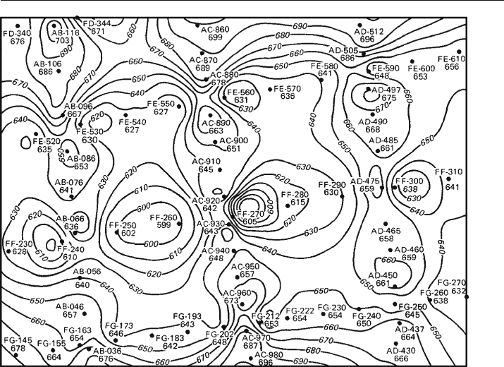
data set can be internally consistent, but one may have elevations systematically shifted
with respect to the other. Cloverleaf patterns of highs and lows (Fig. 10.6) characterize
this type of problem (Jones et al. 1986; Jones and Krum 1992). Two-dimensional seis-
mic lines in areas of dipping units have the additional problem that the reflections on
lines parallel to strike may be shifted laterally from the surface location of the line,
leading to a similar datum shift between lines that are at right angles to one another
(Oliveros 1989). Mis
-ties between reflectors and incorrect stacking velocities can lead
to similar cloverleaf patterns.
10.3
Trend Incompatibilities
The basic principle of trend compatibility is that the trends obtained from different
parts of the total data set, which may include structure contour maps, geological con-
tact locations and bedding attitude measurements, must agree, or a reason for any
discrepancies must be found.
Structure contours are a valuable aid in evaluating the validity of the contact
locations on a geological map. To test the preliminary geologic map of Fig. 10.7a,
find the orientations of the structure contours implied by both the top and bottom
Fig. 10.6. Cloverleaf structure contour pattern produced by data along three north-south seismic lines
mis-tied to three east-west lines. Control points are indicated by dots. Contours are concentrated along
lines of data collection. (Jones et al. 1986)
10.3 · Trend Incompatibilities
290 Chapter 10 · Quality Control
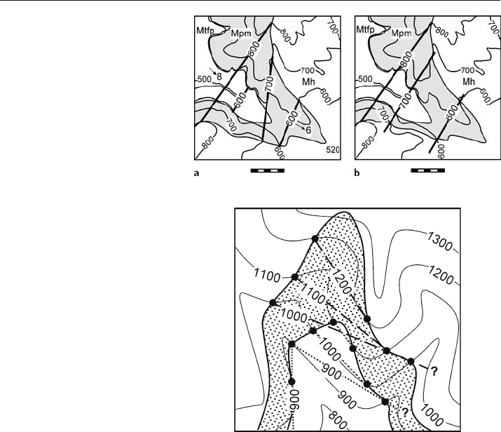
boundaries of the Mpm (Fig. 10.7a). The 800-ft and 600-ft contours are parallel, but
the 700
-ft contour is quite different, suggesting that the contact locations producing
the 700
-ft contour could be wrong. The map is improved by changing the least certain
outcrop trace to make the 700
-ft contour to be parallel to the others (Fig. 10.7b). The
revised map becomes a new working hypothesis which should be field checked.
The consistency between a structure contour map and bedding attitudes from out-
crop measurements or dipmeters provides a powerful test of the interpretation. The
fold axis trend must be consistent with the structure contour trend. The potential
problem is illustrated with the map in Fig. 10.8. If the formation boundary elevations
are sampled at individual points around the structure, they will be contoured as shown
(previously discussed in Sect. 5.5). A problem will be recognized only if compared to
the trend of the fold axis, which trends north–south with zero plunge. The correct
structure contours are shown in Fig. 10.9a. This interpretation would be clear with
good exposure in the field (Fig. 10.9b), but in the subsurface could not be interpreted
without knowledge of the fold axis.
A few locations with dip information can be used to test and control the structures.
The information provided by a small number of formation tops alone can be con-
toured in numerous ways as evidenced by the two maps (Fig. 10.10a and 10.10b)
Fig. 10.7.
Geologic map. Units from
youngest to oldest are Mh,
Mpm, Mtfp. Topographic el-
evations are in feet and the
scale bar is 1000 ft. a Structure
contours (heavy lines) deter-
mined from the intersection of
mapped formation boundaries
with the topographic contours.
b Revised geologic and struc-
ture-contour map
Fig. 10.8.
Structure contours on the top
and base of an outcropping
unit on a topographic map.
Structure contours drawn be-
tween closest corresponding
elevations across the V formed
by the outcrop trace. Solid
dots are control points; long
dash contours are on top of
the bed; dotted contours are
on the base of the bed. Ques-
tion marks show where struc-
ture contours indicate that the
bed surface should intersect
the topographic surface but
no intersection is observed
