El-Rabbany A. Introduction to GPS
Подождите немного. Документ загружается.


When collecting soil samples, GPS is used to precisely locate the
sample points from a predefined grid (Figure 10.3). After testing the
soil samples, information such as nitrogen and organic material contents
can be obtained. This type of information is mapped and used as a
reference to guide farmers in efficiently and economically treating soil
problems.
When GPS is integrated with an aerial guidance system, the field
sprayer can be guided through a moving map display. Based on the spray-
ers location, the system will apply the chemicals at the right spots, with
minimal overlap, and automatically adjust their rate. This, in addition
to increasing productivity, ensures that chemicals and fuel are used
efficiently.
GPS is also used to map crop yields. As the DGPS-equipped harvester
moves across the field, yield rates are recorded along with DGPS-derived
positions. This information is then mapped to show the yield rate.
Easy-to-use integrated systems with only a few buttons are now avail-
able on the market. DGPS corrections are available from the government-
operated DGPS/beacon service free of charge, as well as from a number of
commercial services. The users own base station may be built as well
(Figure 10.3).
10.4 GPS for civil engineering applications
Civil engineering works are often done in a complex and unfriendly envi-
ronment, making it difficult for personnel to operate efficiently. The ability
of GPS to provide real-time submeter- and centimeter-level accuracy in
a cost-effective manner has significantly changed the civil engineering
industry. Construction firms are using GPS in many applications such as
road construction, Earth moving, and fleet management.
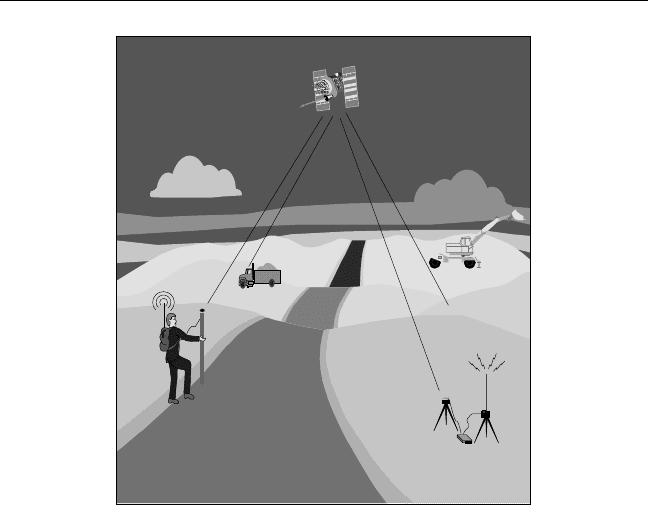
In road construction and Earth moving, GPS, combined with wireless
communication and computer systems, is installed onboard the Earth-
moving machine [5]. Designed surface information, in a digital format, is
uploaded into the system. With the help of the computer display and the
real-time GPS position information, the operator can view whether the
correct grade has been reached (see Figure 10.4). In situations in which
millimeter-level elevation is needed, GPS can be integrated with rotated
beam lasers [6].
GPS Applications 133
TEAMFLY
Team-Fly
®
The same technology (i.e., combined GPS, wireless communications,
and computers) is also used for foundation works (e.g., pile positioning)
and precise structural placement (e.g., prefabricated bridge sections and
coastal structures). In these applications, the operators are guided through
the onboard computer displays, eliminating the need for conventional
methods [7].
GPS is also used to track the location and usage of equipment at differ-
ent sites. By sending this information to a central location, GPS enables
contractors to deploy their equipment more efficiently. Moreover, vehicle
operators can be efficiently guided to their destinations.
10.5 GPS for monitoring structural deformations
Since its early development, GPS has been used successfully in monitoring
the stability of structures, an application that requires the highest possible
accuracy. Typical examples include monitoring the deformation of dams,
134 Introduction to GPS
Radio
Base
Figure 10.4 GPS for construction applications.

bridges, and TV towers. Monitoring ground subsidence of oil fields and
mining areas are other examples where GPS has been used successfully. In
some cases, GPS may be supplemented by other systems such as INS or
total stations to work more efficiently. Deformation monitoring is done
by taking GPS measurements over the same area at different time
intervals [7].
Slow-deforming structures such as dams require submillimeter- to
millimeter-level accuracy to monitor their displacement. Although this
accuracy level may be achieved with GPS alone under certain conditions, it
is not a cost-effective method [7]. To effectively monitor such structures,
GPS should be supplemented with geotechnical sensors and special types
of total stations.
Bridges, in contrast, are subjected to vibrations caused by dynamic
traffic loads. To effectively monitor such cyclic deforming structures, dual
GPS receivers should be located at several points with maximum ampli-
tude of cyclic deformation [7]. For example, in monitoring the worlds
longest suspension bridge (Akashi Bridge, Japan), a GPS receiver is
installed at the midpoint of the bridge while two others are installed at the
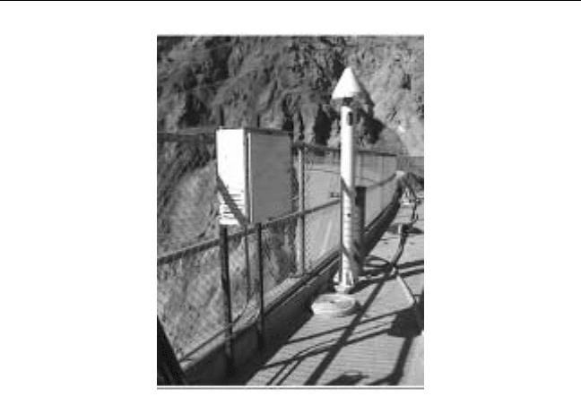
main towers. Figure 10.5 shows another example in which the Ashtech Z12
dual-frequency receiver is used for monitoring bridge deformation. As the
GPS data collection rate is currently limited to 10 Hz, an INS system may
supplement the GPS system, in some cases, to monitor the high-frequency
portion of the structure vibration.
10.6 GPS for open-pit mining
Until recently, conventional surveying was the only method available for
staking drill patterns and other mining surveying. As a result of the harsh
mining environment, however, stakes were often buried or displaced. In
addition, drill operators had no precise way of determining the actual bit
depth. Likewise, there was no way of monitoring the drill performance in
the various geological layers or monitoring the haul trucks in an efficient
way. More recently, however, the development of modern positioning sys-
tems and techniques, particularly RTK GPS, has dramatically improved
various mining operations [8, 9]. In open-pit mines, for example, the use
of RTK GPS has significantly improved several mining operations such as
drilling, shoveling, vehicle tracking, and surveying. RTK GPS provides
GPS Applications 135
centimeter-level positioning accuracy, and requires only one base receiver
to support any number of rovers. As the pit deepens, part of the GPS signal
may be blocked by the steep walls of the mine, causing a positioning prob-
lem. However, this problem, has been successfully overcome by integrating
GPS with other positioning systems, mainly the pseudolite system (see
Section 9.5) [10].
The mining cycle includes several phases, with ore excavation being
one of the most important [11]. Excavating the ore is done by drilling a
predefined pattern of blast holes, which are then loaded with explosive
charges. The pattern of blast holes is designed in such a way that the size of
the rock fragmentation is optimized. As such, it is important that the drills
be precisely positioned over the blast holes, or otherwise redrilling may be
required. An efficient way of guiding the drills is through integrating GPS
with a drill navigation and monitoring system consisting of an onboard
computer and drilling software. Some systems utilize two GPS receivers,
mounted on the top of the drill mast, for precise real-time position and ori-
entation of the drill. The designed drill patterns are sent to the onboard
computer via radio link, and are then used by the integrated system to
136 Introduction to GPS
Figure 10.5 GPS for monitoring bridge deformation. (Courtesy of Magellan
Corporation.)
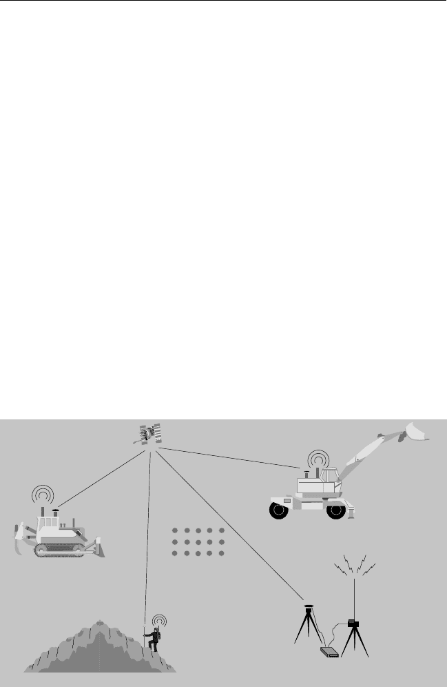
guide the drill operator to precisely position the drill over blast holes (see
Figure 10.6). This is done automatically without staking out. In addition,
the onboard computer displays other information such as the location and
depth of each drill hole. This is very important as it allows the operator to
view whether or not the target depth has been reached. As well, the system
accumulates information on the rock hardness and the drill productivity,
which can be sent to the engineering office in near real time via radio link.
Such information can be used not only in monitoring the drill productivity
from the engineering office, but also in understanding the rock properties,
which enables better future planning [11].
GPS is also used for centimeter-level-accuracy guidance of shoveling
operations (Figure 10.6). Shovels are used in loading the ore into the haul
trucks, which then transport it and unload it in stockpiles. With an inte-
grated GPS and shovel guidance and monitoring system, elevation control
can be automated. With the help of the system display, shovel operators are
able to keep the correct grade. This is done automatically without the need
for grade control by conventional surveying methods. Similar to the drill-
ing, shoveling productivity can be sent to the engineering office in near real
time via radio link for monitoring and analysis.
GPS Applications 137
Radio
Base
Volume
surveying
Earth
moving
Shovel
operations
Drilling
Figure 10.6 GPS use in open-pit mining.

In transporting the ore, haul trucks use continuously changing mining
roads and ramps. Unless efficiently routed, safety and traffic problems
would be expected, which cause an increase in the truck cycle time. The use
of GPS, wireless communication, and a computer system onboard the haul
trucks solve this problem efficiently. With the help of a computerized dis-
patch system, haul trucks can be guided to their destination using the best
routes. In addition, the dispatch center can collect information on the
status of each haul truck as well as the traffic conditions. Analyzing the traf-
fic conditions is particularly important in devising a more appropriate
road design [11].
GPS is also used in other phases of the mining cycle, for example, in
checking the coordinates of the individual points and volume surveying.
Either the RTK or the non-RTK GPS could be used for these functions
(Figure 10.6).
10.7 GPS for land seismic surveying
Oil and gas exploration requires mapping of the subsurface geology
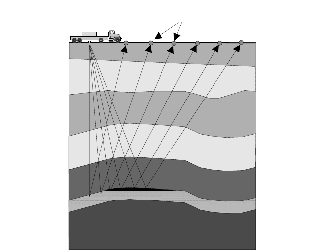
through seismic surveying. In land seismic surveys, low-frequency acoustic
energy is sent down into the underground rock layers (Figure 10.7). The
source of the acoustic energy is often selected to be a mechanical vibrator
consisting of a metal plate mounted on a truck. The plate is pressed against
the ground and vibrated to produce the acoustic energy. In rough areas,
dynamite is still being used as the energy source.
As the acoustic energy (signal) crosses the various underground rock
layers, it is affected by the physical properties of the rocks. Portions of the
signal are reflected back to the surface by the various layers. The reflected
energy can be detected by special seismic devices called geophones, which
are laid out at known distances from the energy source along the survey
line (Figure 10.7). Upon detecting seismic energy, geophones output elec-
trical signals that are proportional to the intensity of the reflected energy
[12]. The electrical signals are then recorded on magnetic tapes for geo-
physical analysis and interpretation.
It is clear that unless the positions of the energy source and the geo-
phones are known with sufficient accuracy, the very expensive seismic data
becomes useless. GPS is used to provide the positioning information in a
standard or a user-defined coordinate system. Integrated GPS/GLONASS
138 Introduction to GPS
and GPS/digital barometer systems have been used successfully in situa-
tions of poor GPS signal reception [13]. With the help of GPS, the environ-
mental impacts (e.g., the need to cut trees) as well as the operating cost of
seismic surveys have been reduced significantly.
10.8 GPS for marine seismic surveying
Marine seismic surveying is similar in principle to land seismic surveying.
That is, a low-frequency acoustic energy is sent down into the subsurface
rock layers, and is reflected back to the surface to reveal information about
the composition of subsurface rocks (Figure 10.8).
Different methods are used in marine seismic surveys depending on
the water depth. In deep waters, seismic vessels tow seismic cables, known
as streamers, which contain devices called hydrophones used for detecting
reflected energy. A single vessel will normally tow four to eight parallel
streamers; each has a length of several kilometers [12]. The low-frequency
GPS Applications 139
Energy source
Geophones
Figure 10.7 GPS for land seismic surveying.
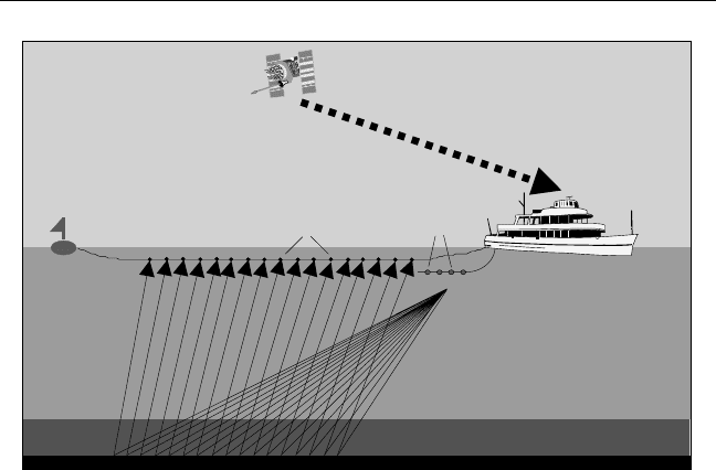
acoustic energy is generated using a number of air guns towed behind the
vessel at about 6m below the surface. In shallow waters, both the land and
the marine methods are used. Ocean bottom cable (OBC) survey is a rela-
tively new technology that has been used recently for water depth of up to
about 200m. In this method, hydrophones and geophones are combined in
a single receiver to avoid water column reverberation (Figure 10.8).
To obtain meaningful results, the positions of the energy source and
the hydrophones must be known with sufficient accuracy. This can be eas-
ily achieved, at lower cost, with GPS. Moreover, it is possible to revisit the
points precisely with the GPS waypoint feature (see Section 10.15).
As the operation of marine seismic surveys is very expensive, the issue
of quality control (QC) is essential. To maintain QC, the seismic industry
has suggested the use of two independent positioning systems, with GPS
being the primary one [12].
10.9 GPS for airborne mapping
GPS alone has been successfully used for topographic mapping of small-
size areas. Using either conventional GPS kinematic surveying or GPS
140 Introduction to GPS
GPS signal
Energy
source
Hydrophones
Tailbuoy
Marine
seismic
vessel
Figure 10.8 GPS for marine seismic surveying.
RTK, a user takes positions of the points on the ground where the topogra-
phy changes, which can be used at a later time to produce the topographic
map of that area. Even in rough areas, GPS can be mounted on all-terrain
vehicles (ATVs) to precisely map those areas. However, there exist situa-
tions in which the use of GPS alone becomes time-consuming and/or cost-
ineffective [14]. Examples include mapping large areas, coastal areas,
forests, and inaccessible areas.
Traditionally, mapping large and inaccessible areas was done using
classical airborne photogrammetry. With this method, an aircraft-
mounted camera is used to capture a sequence of images for the area to be
mapped, which after processing construct the map. To be of practical use,
the captured images must first be related to the geodetic reference system
(e.g., WGS 84), a process known as georeferencing the images. In classical
airborne photogrammetry, the georeferencing is done indirectly with the
help of a number of ground control stations with known geodetic coordi-
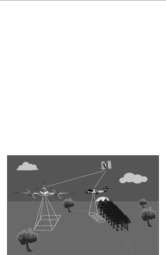
nates and their corresponding image coordinates. In recent years, GPS has
been used onboard the aircraft to provide the precise position of the aerial
camera as well as the precise time of each aerial exposure (Figure 10.9) [15].
The use of GPS in airborne photogrammetry has significantly reduced
the required number of ground control points. It has not, however,
GPS Applications 141
Aerotriangulation
LIDAR
Figure 10.9 GPS for airborne mapping.

eliminated the necessity for aerial triangulation or the ground control
points. This limitation, however, was overcome by augmenting GPS with a
high-quality IMU; see Section 9.4 for details about this integration. The
integrated GPS/inertial system provides not only the precise position of
the imaging sensor but also its orientation (attitude). This allows for the
captured images to be directly related to the geodetic reference system
without using ground control points. In other words, direct georeferencing
of the captured images can be achieved when using an integrated GPS/
inertial system onboard the aircraft. In practice, however, a minimum
number of ground control points may be needed for assessing the resulting
accuracy [15].
Direct georeferencing using the integrated GPS/inertial system is
gaining wide acceptance, and is expected to become the standard tool for
rapid determination of the sensor position and orientation. With recent
advances in digital airborne imaging sensors and digital photogrammetric
workstations, the integrated GPS/inertial system will allow for fully digital
photogrammetric workflow to be developed. With digital imaging sensors,
no film development and scanning are required, which further reduces the
time and the cost of photogrammetric work. Other applications such as
airborne remote sensing and light detection and ranging (LIDAR) will
greatly benefit from the direct georeferencing using the integrated
GPS/inertial system. The latter system, LIDAR, uses an airborne laser scan-
ner to measure the altitude of the points above the ground level [16]. Com-
bining the GPS/inertial-based position and orientation of the laser with the
measured altitude of the points leads to direct acquisition of accurate digi-
tal elevation models (DEM). Another advantage of the LIDAR system is
that the data can be collected at night as well as under cloudy and high wind
conditions. In addition, the ability of the laser to penetrate to the ground,
even in forest areas, makes the airborne laser system attractive to the forest
industry. Moreover, the LIDAR system can be used in mapping featureless
areas such as deserts and areas covered by snow and ice [17].
10.10 GPS for seafloor mapping
Safe and efficient marine navigation requires, among other factors, accu-
rate information about the water depth and the sea bottom [18]. In addi-
tion, the availability of accurate water depth is vital for making use of
142 Introduction to GPS
