Boyle G. (Ed.) Renewable Electricity and the Grid: The Challenge Of Variability
Подождите немного. Документ загружается.

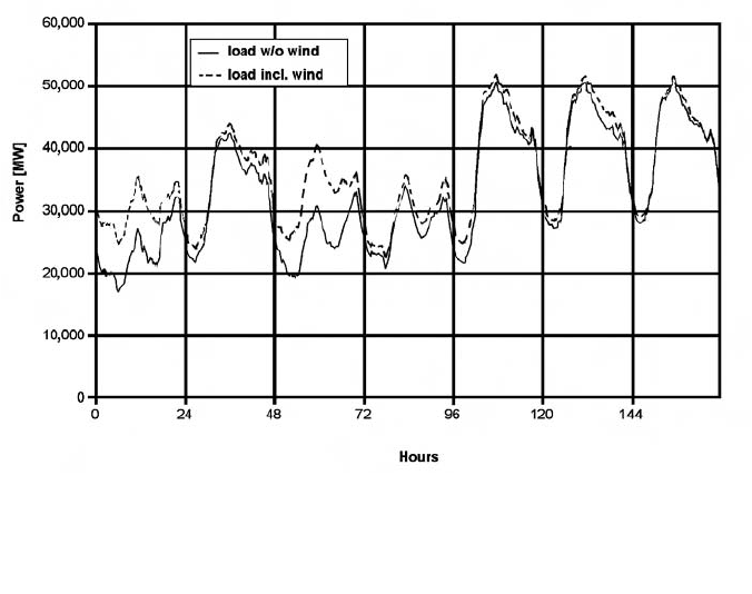
production follows the predicted load curve. Deviations of the actual from the
predicted load are equalized by using balancing power.
The dark band shown in Figure 5.1 was the share of electricity generated
by wind power in Germany during this week. The wind power production
varied between almost zero on the last day and up to about 10 gigawatts (GW)
on day three. Conventional power plants had to supply only the share of the
load shown by the lower curve. If wind power generation was not predicted,
it would appear as an additional and unknown ‘negative load’ and would
require an extremely large use of balancing energy. This is technically and
economically undesirable. Instead, the forecast power output from wind power
is used together with the load forecast to schedule the conventional power
plants. In this way, only the errors in the forecasts have to be balanced by
balancing energy. This also clearly shows that the forecast error determines the
need of balancing energy in order to integrate wind power.
A wind power forecast is indispensable for system operation and security.
Its accuracy is directly connected to the need for balancing energy and, hence,
to the cost of wind power integration. Consequently, a large amount of
research has been directed towards developing high-quality and reliable wind
power forecasts during recent years, and many different forecasting systems
with different approaches have been developed. In countries with a substantial
share of wind power in the electricity system, such as Denmark, Germany or
Spain, wind power forecasting systems are already an essential part of grid and
system control.
96 Renewable Electricity and the Grid
Figure 5.1 Load and wind power generation for one week in Germany
(2003)
3189 J&J Renew Electricity Grid 6/8/07 7:35 PM Page 96
APPLICATIONS OF WIND POWER FORECASTING
The most important application for wind power forecasting is to reduce the
need for balancing energy and reserve power, which are needed to integrate
wind power within the balancing of supply and demand in the electricity
supply system (i.e. to optimize power plant scheduling). This leads to lower
integration costs for wind power, lower emissions from the power plants used
for balancing, and, subsequently, to a higher value of wind power.
A second application is to provide forecasts of wind power feed-in for grid
operation and grid security evaluation. To assess the security of the grid and to
operate it (e.g. for maintenance and repair), the grid operator needs to know
the current and future wind power feed-in at each grid connection point.
The objectives of a wind power forecast therefore depend upon the appli-
cation:
• For optimized power plant scheduling and power balancing, an accurate
forecast of the wind power generation for the whole control zone is needed.
The relevant time horizon depends upon the technical and regulatory
framework (e.g. the types of conventional power plants in the system and
the trading closure times).
• For determining the reserve power that has to be held ready to provide
balancing energy, a prediction of the accuracy of the forecast is needed.
Since the largest forecast errors determine the need for reserve power, these
have to be minimized. In Germany, the relevant forecast horizon is usually
rather long (i.e. predicted one day ahead).
• For grid operation, the current and forecast wind power generation in each
grid area or grid connection point is needed. This requires a forecast for
small regions or even single wind farms. For grid management, shorter time
horizons are often relevant. Switching and other grid operations do not
have a long lead time and therefore a higher accuracy of short-term fore-
casts is more important.
STEPS IN A FORECASTING SYSTEM
In producing a wind power forecast, different steps can be distinguished:
• numerical weather prediction;
• wind power output forecast;
• regional upscaling.
As the first step, a weather prediction, including the forecast of the wind speed
and possibly some other meteorological parameters, is needed for a wind power
forecast. This is provided by numerical weather prediction (NWP) models.
Most often, two or more hierarchical levels with different NWP models and
increasing resolution are used (see the section on ‘Numerical weather
prediction’). Very simple systems use as a substitute for NWP models measured
Wind Power Forecasting 97
3189 J&J Renew Electricity Grid 6/8/07 7:35 PM Page 97
wind speeds from a location in the direction of the mean pressure systems
movement. It is possible to compute forecasts without weather prediction from
actual measurements of power output, but only for very short forecast horizons.
The NWP data is used as input to the next step: the wind farm power-
output forecasting. This takes into account the local meteorological influences
on the wind speed and direction, the power conversion characteristics of the
turbine, wind farm shading, and other effects that influence the power output.
Different approaches and combinations of approaches have been developed
and are in use (see the section on ‘Different approaches to the power output
forecast’). For forecasts with a shorter forecast horizon, online measured wind
speeds and/or wind farm power output are used as additional input to the fore-
casting (see the section on ‘Forecast horizon’).
If the forecast is needed for a larger region with very many wind farms or
wind turbines, forecasts are compiled only for some representative wind farms
and the results from these are scaled up to regional forecasts as a third step (see
the section on ‘Regional upscaling’).
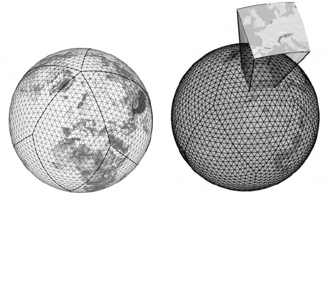
NUMERICAL WEATHER PREDICTION
Weather forecasts from numerical weather prediction models (NWP models)
are the most essential input needed for almost all wind power forecast models.
Usually a model chain of hierarchical levels with different NWP models and
increasing resolution is used.
The model chain starts with meteorological measurements and observa-
tions all over the globe, performed by meteorologists, weather stations,
satellites and so on. All available data are used as input to a global NWP
model, which models the atmosphere of the entire Earth. The NWP model
calculates the future state of the atmosphere from the physical laws governing
the weather. Since these calculations are very computationally expensive, the
resolution of a global model has to be rather coarse (see Figure 5.2, left).
Global models are in operation at only about 15 weather services.
To provide more accurate weather forecasts, local area models (LAMs) are
used, which cover only a small part of the Earth but can be run with a much
higher resolution (see Figure 5.2, right). These models use the forecasts of the
global model as input and calculate a weather forecast, taking into account the
local characteristics of the terrain.
NWP models are usually run operationally by national weather services.
Most of these only run a LAM for their region of interest and use data from
other global models as input. Some commercial companies also run NWP
models, and dedicated service companies also operate NWP models especially
for wind power forecasting.
One example of a LAM is the LME model (Doms and Schättler, 1999). It
covers central Europe with 325 325 grid cells. This leads to a horizontal
resolution of about 7 7km. The forecast horizon of the operational model is
48 hours and the resolution is 1 hour. Model runs are started thrice daily at 00
coordinated universal time (UTC), 12 UTC and 8 UTC.
98 Renewable Electricity and the Grid
3189 J&J Renew Electricity Grid 6/8/07 7:35 PM Page 98
In some model systems, a third step is performed using a high resolution meso-
scale model with an even higher resolution. This is especially important if the
LAM available has low resolution and the terrain is complex. The meso-scale
models can either be run by the provider) of the weather prediction data (i.e.
a weather service provider or as part of the wind power forecast model.
In practical applications, different NWP model data are often available for
a wind power forecast. Important criteria for the selection of the most appro-
priate NWP model(s) are:
• area covered;
• spatial and temporal resolution;
• forecast horizon;
• accuracy;
• number of runs and their calculation time.
DIFFERENT APPROACHES TO THE POWER OUTPUT
FORECAST
The aim of a wind power forecast is to link the wind prediction of the NWP model
to the power output of the wind farm. Three fundamentally different approaches
can be distinguished:
Wind Power Forecasting 99
Source: Reproduced with kind permission of the DWD (German Weather Service)
Figure 5.2 Horizontal grid of a global numerical weather prediction model
and enlarged area covered by a local area model
3189 J&J Renew Electricity Grid 6/8/07 7:35 PM Page 99
1 The physical approach aims to describe the physical process of converting
wind to power, and models each of the steps involved.
2 The statistical approach aims at describing the connection between
predicted wind and power output directly by statistical analysis of time
series from data in the past.
3 Finally, the learning approach uses artificial intelligence (AI) methods to
learn the relationship between predicted wind and power output from time
series of the past.
In practical applications, the methods are sometimes combined or mixed.
Models with a physical approach almost always use data from the past to tune
their models or use model output statistics (MOS) for a correction of the result.
On the other hand, models using statistical or AI methods often use knowledge
of the physical processes, such as the shape of the power curve, in designing
their models.
The physical approach contains a chain of models of the different physical
processes involved:
• wind conditions at the site and hub height of the turbines;
• wind farm shading effects;
• turbine power curve;
• model output statistics (MOS).
The wind prediction of a NWP model represents a mean wind speed over the
area of one grid cell of the model at a certain height. As a first step, the site-
specific wind speed and direction at hub height of the turbines has to be
calculated. The models used for this are either micrometeorological models,
such as the WAsP model (Mortensen et al, 1993) and/or flow models, usually
meso-scale models such as MM5 (Grell et al, 1994). These models take into
account the influence of the vertical wind speed profile, the orography of the
terrain, the surface roughness and thermal effects. In a second step, wind farm
shading effects are calculated by a wind farm model, such as PARK (PARK,
1993) or FLaP (FLaP, 2002). The turbine power curve is then used to convert
the wind speed at each turbine into the expected power output. Finally, model
output statistics are used to correct the results for systematic deviations caused
either by uncertainties in the information needed by the models or by inaccu-
racies in the models. MOS is a statistical correction method based on time
series of the past. It is essential for the good forecasting quality of a physical
model since the physical processes are highly complex and the information
needed for the models often has limited accuracy. The models require detailed
knowledge about the wind farms to be forecast (e.g. the terrain around the
wind farm, the layout of the farm and the power curve of the turbines).
Statistical approaches analyse the connection between weather forecasts
and power production from time series of the past and describe this connec-
tion in a way that enables it to be used for the future.
Like statistical models, artificial intelligence methods also describe the
connection between input data (the predictions of the NWP model) and output
100 Renewable Electricity and the Grid
3189 J&J Renew Electricity Grid 6/8/07 7:35 PM Page 100

data (wind farm power output). But instead of an explicit statistical analysis,
they use algorithms that are able to implicitly describe non-linear and highly
complex relations between this data. Different methods are used for this, such
as:
• artificial neural networks;
• support vector machines;
• nearest neighbour search.
For both the statistical and AI approach, long and high-quality past time series
of weather predictions and power output are of essential importance.
Each of these approaches is used in practical applications. The physical
approach is, for example, used in the Prediktor (Landberg, 1994, 2001) and
Previento (Focken et al, 2001; Focken et al, 2002) models. The WPPT (Nielsen
and Madsen, 1997; Nielsen et al, 2002) model uses a statistical approach,
while the WPMS (Rohrig and Ernst, 2000; Lange et al, 2006) model uses an
artificial intelligence approach. For an overview of different models, see
Landberg et al (2003), Giebel et al (2003) and Lange and Focken (2005). The
main advantages and drawbacks of different approaches for the power output
forecasts are summarized in Table 5.1.
Table 5.1 Summary of the main advantages and drawbacks of different
approaches for a power output forecast
Statistical and artificial intelligence Physical approach
approaches
+ No physical insight necessary + Chance to understand physical behaviour
+ Fast calculation + Measurement data less important
– Depends upon high-quality and – Needs extensive information about
long-term measurement data wind farms
– Situations with limited numbers of – Great effort in the set-up
observations are difficult
FORECAST HORIZON
The forecast horizon is the time period between the time at which the forecast
is available and the forecast point in time. Different forecasts are used for
different purposes and their forecast horizons depend upon the requirements
of the user, stemming from technical and regulatory conditions, and upon the
feasibility of forecasting.
From the meteorological and climatological point of view, one can distin-
guish long-term or seasonal forecasts with a forecast horizon of several
months, medium-term forecasts with a range of up to two weeks, short-term
Wind Power Forecasting 101
3189 J&J Renew Electricity Grid 6/8/07 7:35 PM Page 101
forecasts for the next few days, and very short-term forecasts for a forecast
horizon of up to one day. Generally, the forecast accuracy decreases with
increasing forecast horizon.
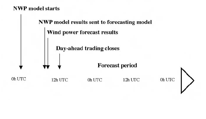
For current wind power forecasting, deterministic forecasts are used up to
a forecast horizon of three to five days. Essentially, two forecast horizons have
to be distinguished: the day-ahead forecast and the short-term forecast. The
day-ahead forecast is mainly used for day-ahead power trading. The forecast
horizon therefore depends upon the organization of the trading (e.g. the gate
closure time and the trading days). An example for a gate closure time of 12.00
am for the next day is shown in Figure 5.3. The NWP model starts running at
midnight with the observations from the day before. It finishes calculation
around 7.00 am and sends the information to the wind power forecasting
system. This usually has a very short calculation time and the results are avail-
able a few minutes later. They are analysed and used for trading the power for
the next day until at 12.00 am the trading ends. This means that the calcula-
tion of the forecast starts 48 hours ahead, counted from the start of the NWP
model. If there is no trading during weekends and pubic holidays, lead time for
the calculation for the ‘day-ahead’ trading can actually be 96 hours or longer.
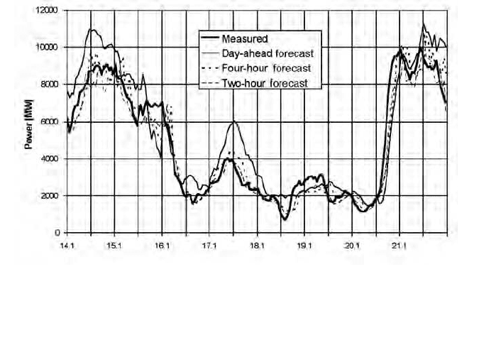
Short-term wind power forecasting is mainly used for intra-day trading
and grid operation and security. Its main characteristic is that it utilizes online
data from measurements of actual power output and/or wind speed. For very
short forecast horizons, this leads to a very important increase in forecast accu-
racy (see Figure 5.4). Usually, NWP model data and online measurement data
are combined for the short-term forecast, giving more weight to the NWP data
for longer forecast horizons and more weight to online data for shorter hori-
zons. Very short-term forecasts of up to one or two hours are possible even
without NWP model data. For forecast horizons of more than approximately
half a day, the online data usually do not add information to the NWP model
data and the short-term forecast ends.
102 Renewable Electricity and the Grid
Figure 5.3 Typical time schedule for wind power forecasting used
for day-ahead trading
3189 J&J Renew Electricity Grid 6/8/07 7:35 PM Page 102
REGIONAL UPSCALING
A wind power forecast for a larger region with many wind farms is usually
made by forecasting only some of the wind farms and by extrapolating their
power output to the whole region – often called regional upscaling. This mini-
mizes the effort involved in making the forecasts and reduces the amount of
data needed from NWP models as input. The accuracy of the forecasts does
not decrease much since wind farms close to each other show a similar behav-
iour. However, it is important that the wind farms selected for forecasting are
representative of all wind farms to which their output is extrapolated.
Different algorithms can be used for upscaling. Their main function is to
calculate the output of all wind farms of the area from the known (or forecast)
output of the representative wind farms. In the Wind Power Management
System (WPMS), developed by ISET in Germany, the following mechanism is
used. The area of interest is subdivided into grid squares. For each of these grid
squares, the installed capacity of wind farms, their coordinates and hub
heights, and the roughness of the terrain are known. This information is
compiled from a database of all wind turbines in Germany, which includes:
• installed power;
• rotor radius;
• hub height;
• location;
• turbine type;
• surface roughness;
• date of erection and dismantling.
Wind Power Forecasting 103
Figure 5.4 Example time series of online measurement and forecasts of wind
power generation in Germany; forecasts with different forecast horizons are
shown
3189 J&J Renew Electricity Grid 6/8/07 7:35 PM Page 103
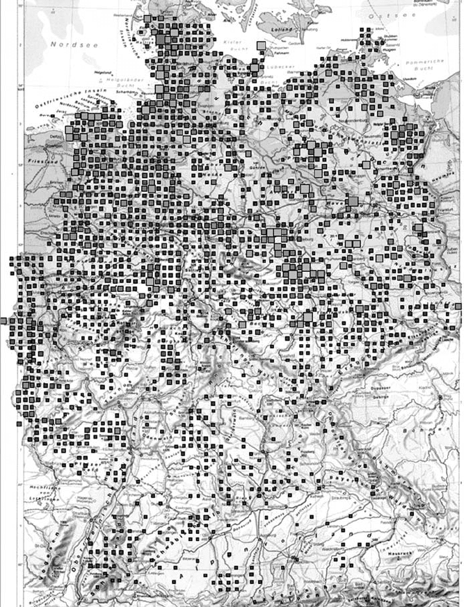
Figure 5.5 Grid squares used by the Wind Power Management System for
regional upscaling
Figure 5.5 shows the grid squares for Germany as an example. The size of the
squares shows information about installed capacity: the smallest squares are 1
megawatt (MW) to 13MW, and the largest squares are 131MW to 146MW.
The WPMS calculates the power output of the wind turbines in each grid
square by using the forecast power output of the representative wind farms.
104 Renewable Electricity and the Grid
3189 J&J Renew Electricity Grid 6/8/07 7:35 PM Page 104

The closer a reference wind farm is to the grid square, the greater is its influ-
ence (see Figure 5.6). Considering a case with i grid squares and j
representative wind farms, the power output of the whole region P
total
is the
sum of the power output P
i
from all its grid squares:
P
total
=
i
P
i
. [1]
The power output of one grid square is calculated from the weighted power
outputs of all representative wind farms:
P
i
= k
i
j
A
ij
P
j
. [2]
Here, P
j
is the power output of representative wind farm j, normalized with its
installed power, and k
i
is a normalization factor. The weighting factors A
ij
are
calculated as:
A
ij
= exp
–S
ij
–––
S
0
P
IP,i
[3]
where P
IP,i
is the installed power in grid square i, S
ij
is the distance between a
representative wind farm and the grid square, and S
0
is a spatial correlation
parameter that has to be determined empirically.
The normalization factor k
i
makes sure that the sum of all weighting
factors equals 1:
1
k
i
= –––––––––– . [4]
j
A
ij
SMOOTHING EFFECT
The power output of wind farms fluctuates. These fluctuations are very diffi-
cult to forecast, and even if the power output on a particular day is predicted
well, the fluctuations will cause a forecast error. The larger the wind farm, the
smaller will be the fluctuations and the corresponding forecast error. If many
wind farms are forecast together, the forecast error decreases further. In addi-
tion, the aggregation of large regions with several gigawatts of installed
capacity will lead to a decrease in the relative forecast error since there will be
cases where the forecast errors of different regions will partly cancel each other
out. An example of this is shown in Figure 5.7, which shows the forecast error
for the three German control zones with large wind power capacity: those of
E.ON, VE-T and RWE, together with the error of the aggregated forecast for
an example time series of four days. It can be seen that the forecast error for
the aggregated wind power always stays below 2.5 per cent, while the error for
Wind Power Forecasting 105
3189 J&J Renew Electricity Grid 6/8/07 7:35 PM Page 105