Awange J.,Grafarend E., Palancz B., Zaletnyik P. Algebraic Geodesy and Geoinformatics
Подождите немного. Документ загружается.


8-4 Extending the Newton-Raphson approach using pseudoinve rse 107
W (x, y, u, v, w) =
p
x
2
+ y
2
+ u
2
+ v
2
+ w
2
→ min W
x,y , u,v,w
(8.12)
under the constrains,
f
i
= 0, i = 1, 2, 3 (8.13)
It is clear that the Newton-Raphson method can not be used. Employing genetic
algorithm, we get,
x = 0.187018, y = −1.08919 × 10
−6
, u = 0.81298, v = 0.000124852, w = 0.504332
with a norm of 0.975.
8-4 Extending the Newton-Raphson approach using
pseudoinverse
Now, in order to avoid these difficulties an extension of the Newton - Raphson
method can be introduced, see [337]. This method uses the pseudoinverse of the
Jacobian, instead of its inverse. The computation of the pseudoinverse is based on
the singular value decomposition technique. Every A matrix m ×n, m ≥ n can be
decomposed as
A=UΣV
T
(8.14)
where (.)
T
denotes the transposed matrix, U an m × n matrix, and V an n × n
matrix satisfying
U
T
U=V
T
V = VV
T
= I
n
(8.15)
and Σ =< σ
1
, ..., σ
n
> a diagonal matrix. These σ
i
’s, σ
1
≥ σ
2
≥, ..., σ
n
≥ 0 are
the square root of the non negative eigenvalues A
T
A and are called the singular
values of matrix A. As it is known from linear algebra e.g. Bernstein [73], singular
value decomposition (SVD) is a technique used to compute the pseudoinverse for
a singular or ill-conditioned matrix of linear systems. In addition, this method
provides a least square solution for overdetermined systems and minimal norm
solutions for the case of undetermined systems.
The pseudoinverse of a matrix A of m ×n is a matrix A
+
of n ×m satisfying
AA
+
A = A, A
+
AA
+
= A
+
,
A
+
A
∗
= A
+
A,
AA
+
∗
= AA
+
(8.16)
where (.)
∗
denotes the conjugate transpose of the matrix. There always exists a
unique A
+
which can be computed using SVD: (a) If m ≥ n and A = UΣV
T
then
A
+
= VΣ
−1
U
T
(8.17)
where Σ
−1
=< 1 /σ
1
, ..., 1 /σ
n
> . b) If m < n then compute the
A
T
)
+
, pseu-
doinverse of A
T
and then
A
+
=
A
T
)
+
T
(8.18)

108 8 Extended Newton-Raphson method
The idea of using pseudoinverse in order to generalize the Newton-Raphson method
is not new. It means that in the iteration formula (8.19), the pseudoinverse of the
Jacobian matrix will be em ployed instead,
x
i+1
= x
i
− J
+
(x
i
) f (x
i
) (8.19)
The pseudoinverse can be computed in a symbolic as well as a numeric form.
For e xample, considering the first example, see Sommese and Wampler’s [367]
equations in Sect. 16-21, the Jacobi matrix is
J(x, y) =
2x 0
y x
0 2y
(8.20)
and its pseudoinverse
J
+
(x, y) =
x
3
+4xy
2
2(x
4
+4x
2
y
2
+y
4
)
y
3
x
4
+4x
2
y
2
+y
4
−
xy
2
2(x
4
+4x
2
y
2
+y
4
)
−
x
2
y
2(x
4
+4x
2
y
2
+y
4
)
x
3
x
4
+4x
2
y
2
+y
4
4x
2
y +y
3
2(x
4
+4x
2
y
2
+y
4
)
!
(8.21)
The Jacobian matrix at the point (x
i
= 1 , y
i
= 1) is,
J(1, 1) =
2 0
1 1
0 2
(8.22)
and the pseudoinverse is
J
+
(1, 1) =
5
12
1
6
−
1
12
−
1
12
1
6
5
12
(8.23)
The new values ( x
i+1
, y
i+1
) in the next iteration step are
1
1
− J
+
(1, 1)
f
1
(1, 1)
f
2
(1, 1)
f
3
(1, 1)
=
1
2
1
2
(8.24)
8-5 Applications of the Extended Newton-Raphson method
Example 8.1 (Overdetermined polynomial system). Let us recall the Sommese
and Wampler’s [367] equations solved in Sect. 8-31. Using the Extended Ne wton-
Raphson method with initial values (x
0
= 1, y
0
= 1), we get the solution (after 40
iterations) as
x = 1.8189894035458573 × 10
−12
, y = 1.81899 × 10
−12
.
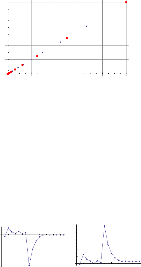
The convergence is shown in Fig. 8.3 and the norm of error is 2.5724394843074972×
10
−12
. We therefore achieved a considerably more accurate result with approxi-
mately the same number of iteration steps as that of Sect. 8-31. This means faster
convergency.

8-5 Applications of the Extended Newton-Raphson method 109
0.2
0.4
0.6
0.8
1.0
x
0.2
0.4
0.6
0.8
1.0
y
Figure 8.3. Convergence of the Extended Newton-Raphson method (big points) while
that of the standard Newton-Raphson (small points)
Example 8.2 (Overdetermined non-polynomial system). Extended Newton-Raphson
method can solve directly the original overdetermined system of Sect. 8-32 with
both initial conditions more quicker than the standard methods (see Chap. 7)
when solving the transformed square one system of equations. In addition, no
transformation of the overdetermined model into a square one is necessary.
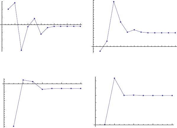
Example 8.3 (Determined system with singular Jacobian). The Extended Newton
Raphson method converge s from all of the different initial values for the c ase
of the Ojika [314] problem that we attempted to solve in Sect. 8-33 using the
standard Newton-Raphson method (i.e., obtaining the roots of the system of the
two polynomials of Eqn. 8.10). Figs.8.4- 8.6 illustrate the fast convergence obtained
when Extended Newton-Raphson is obtained as opposed to the standard Newton-
Raphson (see Fig. ).
5
10
15
2
0
1
5
1
0
5
5
5
10
15
10
20
30
40
50
Figure 8.4. Convergence when starting values are (-1, -1)
Example 8.4 (Underdetermined system). The result produced by the Extended
Newton-Raphson method depends on the initial condition, which is natural in

110 8 Extended Newton-Raphson method
2
4
6
8
10
12
1
.5
1
.0
0
.5
0.5
1.0
1.5
2
4
6
8
10
12
2
4
6
8
10
Figure 8.5. Convergency when starting values are (1, -1)
2
4
6
8
1
.0
0
.8
0
.6
0
.4
0
.2
2
4
6
8
1.5
2.0
2.5
3.0
3.5
4.0
Figure 8.6. Convergency when starting values are (-1, 1)
the case of a local me thod, but no divergence takes place. In order to get the so-
lution with the minimal norm, we computed the solutions with 500 initial values
generated randomly in the interval [- 0.5, 0.5]. The computation took 1.422 sec
and the norm of the solution was 0.977. While using global constrained minimiza-
tion via ge netic algorithm, the computation needed 2.390 sec and the norm of the
solution was 0.975.
8-6 Concluding remarks
The examples demonstrate the efficiency and effectiveness of the suggested method,
especially for cases of overdetermined systems. Although the Extended Newton-
Raphson procedure is a local method, the solution of a square subset of the overde-
termined system can provide a good initial guess for the computation. As a side
effect, the method can also solve determined ill- conditioned problems frequently
arising from geometrically ill-posed configurations e.g. in GPS positioning [41] or
in solving datum transformation problems, see [430]. In addition, the implementa-
tion of this method is quite easy, since the computation of inverse of the Jacobian
matrix could be simply replaced by the pseudoinverse in any Newton - Raphson
procedure.

9 Procrustes solution
“It seems very strange that up to now Procrustes analysis has not been
widely applied in geodetic literature. With this technique linearization prob-
lems of non linear equations system and iterative procedures of computation
could be avoided, in general, with significant time saving and less analytical
difficulties” F. Crosilla.
9-1 Motivation
This chapter presents the minimization approach known as “Procrustes” which
falls within the multidimensional scaling techniques discussed in Sect. 9-22. Pro-
crustes analysis is the technique of matching one configuration into another in-
order to produce a measure of match. In adjustment terms, the partial Procrustes
problem is formulated as the least squares problem of transforming a given matrix
A into another matrix B by an orthogonal transformation matrix T such that
the sum of squares of the residual matrix E = A − BT is minimum. This tech-
nique has been widely applied in shape and factor analysis. It has also been used
for multidimensional rotation and also in scaling of different matrix configura-
tions. In geodesy and geoinformatics, data analysis often require scaling, rotation
and translation operations of different matrix configurations. Photogrammetrists,
for example, have to determine the orientation of the camera during aerial pho-
togrammetry and transform photo coordinates into ground coordinates. This is
achieved by employing scaling, translation and rotation operations. These ope ra-
tions are also applicable to remote sensing and Geographical Information System
(GIS) where map coordinates have to be transformed to those of the digitizing
table. In case of robotics , the orientation of the robotic arm has to b e determined,
while for machine and computer visions, the orientation of the Charge-Coupled
Device (CCD) cameras has to be established. In practice, positioning with satel-
lites, particularly the Global Navigation Satellite Systems (GNSS) such us GPS
and GLONASS has been on rise. The anticipated GALILEO satellites will further
increase the use of satellites in positioning. This has necessitated the transfor-
mation of c oordinates from the Global Positioning System (WGS 84) into local
geodetic systems and vice versa.
A classical problem in geodesy and geoinformatics that would benefit from this
technique is transformation, and in particular the 7–parameter datum transfor-
mation problem. The traditional approach of solving this problem, for instance,
has been to linearize the nonlinear equations and then apply least squares method
iteratively. With the proposed Procrustes approach, all that is required of the user
is to insert the coordinates of one system (e.g., local coordinate system) in say, the
matrix A, and those of the other system (e.g., GPS in WGS-84) into the matrix B.
Using Procrustes analysis technique presented in this chapter, and later in Chap.
17, the desired scale, rotation and translation parameters can be obtained directly.
J.L. Awange et al., Algebraic Geodesy and Geoinformatics, 2nd ed.,
DOI 10.1007/978-3-642-12124-1 9,
c
Springer-Verlag Berlin Heidelberg 2010
112 9 Procrustes solution
Although long applied in other fields such as; sociology, to map crime versus
cities, and also in medicine as we will see in Sect. 9-23, Procrustes method is rela-
tively new to the fields of geodesy and geoinformatics. Its first entry into geodesy
can be traced back to the work of [120, 121] where the method was used in the
creation of the criterion matrix used for deformation analysis. Further applications
include the works of [16, 168, 169] who applies it to compute the three-dimension
orientation parameters, deflection of the vertical, and 7-parameter datum trans-
formation.
Recent application of the approach in geoinformatics can be found in the works
of [123] who employs it to solve the photogrammetric block adjustment by inde-
pendent models, [65] who applies it for size and shape three-dimensional object
reconstructions, and [66] who uses the technique to update cadastral maps. At the
beginning of the Chapter, we quoted F. Crosilla [122], the father of Procrustes in
geodesy and geoinformatics. He wonders why such an amazing technique has not
been widely applied in geodesy.
Procrustes method is a very effective method for determining the Helmert’s
datum transformation parameters since it requires neither initial starting values
nor iteration. Due to this attractive attribute, the ABC-Procrustes algorithm ex-
tended it to solve the 3D affine transformation problem where scale factors are
different in the 3 principal directions X, Y, Z. In this study, it is illustrated that
such direct extension is restricted to cases of mild anisotropy in scaling. For strong
anisotropy, however, the procedure fails. The PZ-method is proposed as an exten-
sion of the ABC algorithm in case of strong anisotropy. The procedures are applied
to determine transformation parameters for; (i) transforming Australian Geodetic
Datum (AGD 84) to Geocentric Datum Australia (GDA 94), i.e., mild anisotropy
and (ii) the Hungarian datum (strong anisotropy). The results indicate that the
PZ-algorithm leads to a global minimization as opposed to the ABC-algorithm al-
beit with slightly longer computational time. However, the ABC-method is found
to be useful for computing proper initial values for PZ-method thereby increasing
its efficiency.
In this chapter, the partial, also called simple Procrustes algorithm which is
sufficient for solving only the rotation elements is presented. It will be demon-
strated how the approach solves the three-dimensional orientation and the vertical
deflection (direction of local gravity vector) problems. In Chap. 17, the general
Procrustes algorithm will be presented and used to solve the 7-parameter similar-
ity transformation problem which is often encountered in practice.
9-2 Procrustes: Origin and applications
9-21 Procrustes and the magic bed
The origin of the name, and perhaps the concept is traced back to Greece. Some-
where in Attica in Greece lived a robber whose name was Procrustes. His house
was so well positioned besides the road such that he was frequented by visitors

9-2 Procrustes: Origin and applications 113
who had to spend the night. In his house, Procrustes also known as Damastes kept
a special bed: So special was the bed such that the visitors were required to fit
in it. Unfortunately for Procrustes, neither were all his visitors of the same height
nor length of the magic bed. All the same, the visitors were somehow forced in
some “magic” way to fit into the magic bed. This was not done by adjusting the
bed, but to the contrary its occupants! Procrustes devised ways to fit his quests
onto his bed. Guests who were shorter for the bed were stretched by hammering
or racking their bodies to fit the bed, while those who were longer had their legs
chopped off! In both cases, the victims died. As fate would have it, Procrustes was
himself adjusted to fit his own bed by Theseus, a young Attic hero whose mission
was to eliminate robbers. The Encyclopedia of Greek Mythology writes
1
:
“Procrustes (proh-KRUS-teez). A host who adjusted his guests to their
bed. Procrustes, whose name means “he who stretches”, was arguably the
most interes ting of Theseus’s challenges on the way to becoming a hero.
He kept a house by the side of the road where he offered hospitality to
passing strangers, who were invited in for a pleasant meal and a night’s
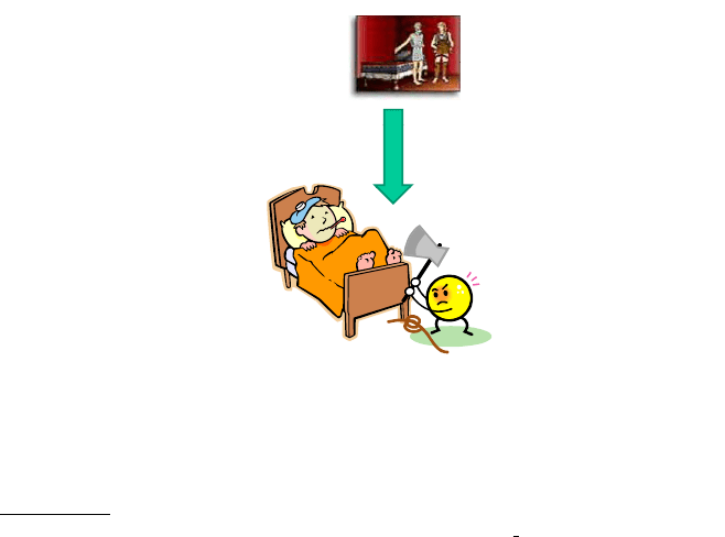
rest in his very special bed (see Fig. 9.1
1
). Procrustes described it as having
the unique property that its length exactly matched whomsoever lay down
upon it. What Procrustes didn’t volunteer was the method by which this
“one-size-fits-all” was achieved, namely as soon as the guest lay down
Procrustes went to work upon him, stretching him on the rack if he was
too short for the bed and chopping off his legs if he was too long. Theseus
turned the tables on Procrustes, fatally adjusting him to fit his own b e d.”
Figure 9.1. Procrustes and his “magical” bed
This magic bed of Procrustes has become a saying for arbitrarily - and perhaps
ruthlessly - forcing someone or something to fit into an unnatural scheme or pat-
tern.
1
http://www.mythweb.com/encyc/gallery/procrustes c.html
c
Mythweb.com
114 9 Procrustes solution
9-22 Multidimensional scaling
Multidimensional scaling (MDS) is a method that represents meas urements of
similarity (or dissimilarity) among pairs of objects such as distances between points
of low-dimensional multidimensional space. Let us consider for example that data
consists of intelligence tests and that one desires to see the correlation between the
tests. MDS can be used to represent these data in a plane such that the correlation
can be studied. The more closer the points are (i.e., the shorter the distances
between the points), the more correlated they are. MDS thus gives an advantage
of graphical visualization of hidden adherent properties between objects. MDS has
been described by [87] as:
• An approach for representing similarity and dissimilarity data as exemplified
by distances of low dimensional space. This is done in-order to make this data
accessible for visual inspection and exploration.
• An approach for testing if and how certain criteria by which one distinguishes
among different objects of interest are mirrored in a corresponding empirical
differences of this object (i.e., correlated).
• A data analytic approach that allows one to discover the three-dimensions that
underlie judgements of dissimilarity and similarity.
• A psychological model that explains judgements of diss imilarity in terms of a
rule that mimics a particular type of distance function.
Procrustes approach therefore is a procedure that is applied to realize the goals
of MDS. In other words, it is a tool of MDS concerned with the fitting of one
configuration into another as close as possible.
9-23 Applications of Procrustes in medicine
As a m otivational urge to embrace this long overdue powerful tool, this section
presents briefly two areas where Procrustes procedure has found practical appli-
cation. These are:
• Procrustes application software for gene recognition [150].
• Identification of malarial parasites [130].
The technique has also been applied in various fields ranging from biology, psy-
chology, to structural analysis etc.
9-231 Gene recognition
Gene recognition started as a statistical analysis and splicing sites. The statis-
tical procedures however could not deal with other types of genes such as eu-
karyotic (i.e., a single-celled or multicellular organism whose cells contain a dis-
tinct membrane-bound nucleus). To solve this problem, researchers in the field
developed PROCRUSTES software, which uses similarity-based approach to gene

9-2 Procrustes: Origin and applications 115
recognition [150]. This was achieved using spliced alignment technique. The soft-
ware is reported by Human Genome News
2
to be able to identify with remarkable
accuracy human version of genes that are in other forms of life. The human genes
are broken into smaller segments known as exons. Searching for exons is analo-
gous to following a magazine article that appears in, say, pp. 5, 23, 84, and 93,
with almost identical advertisement and other articles appearing between. The
software is applied to construct all these pages that contain the required article
and automatically combine them into a best fitting set. The technique is said to
work best when a “target protein” from the nonhuman sample guides the search,
thus ensuring an accuracy that approaches 100%. In this technique, if a genomic
sequence and a set of candidate exons are given, the algorithm explores all possible
exon as semblies and finds a chain with the best fit to relate target protein. Instead
of trying to identify the correct exons by statistical means (which predicts the
correlation between the predicted and the actual gene to 70%, with just 40-50%
exons predicted correctly), PROCRUSTES considers all possible chain with the
maximum global similarity to the target protein. The procedure predicts a corre-
lation of about 99% between the predicted and the actual gene [150]. The tool is
useful in pinp ointing elusive human version of cancer-causing gene!
9-232 Identification of malaria parasites
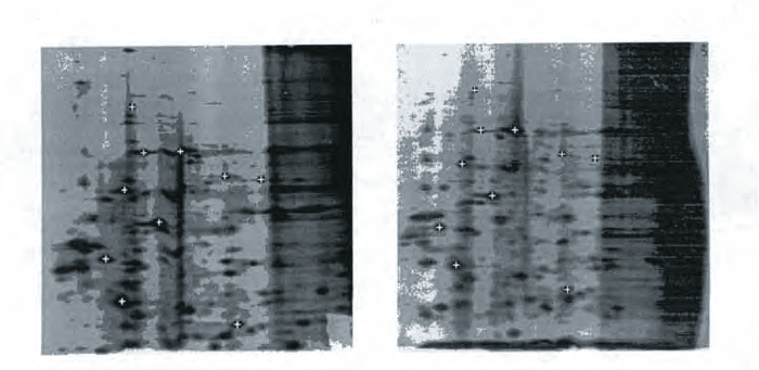
Dryden [130] applies Procrustes to identify proteins by comparing the elec-
trophoretic gel images (Fig. 9.2
3
). The gels are obtained from strains of parasite
which carry malaria. The procedure uses Procrustes matching and affine shape
registration to match the gels. It applies some biological material to the left corner
of the two images of gels A and B in Fig. 9.2. The material is then separated down
the gel according to molecular weight (with the highest on top) and across the
gel according to isoelectric point (with the highest on the right of the gel). Gel
image is then used to identify strains of parasites using pattern of spots marked
by (+). Dark spots appearing on the gels indicate the composition of protein and
are marked by some expert in both gels A and B. Ten spots are marked in each
gel and then classified as either invariant or variant spots.
The invariant spots are considered to be present for all parasites. The arrange-
ment of the variant spots is of particular interest as it helps in the identification
of malarial parasite. The field problem sighted by [130] however is that gels are
prone to deformation such as translation, scaling, rotation, affine transformation
and smooth-linear bending. Gel images therefore need to be registered by matching
each image using a set of transformation to alleviate the deformations above [130].
This is achieved through the use of Procrustes analysis.
2
July-September 1996; 8:(1)
3
c
Chapman and Hall Press

116 9 Procrustes solution
Figure 9.2. The electrophoretic gels from gel A and gel B. Ten invariant spots have
been marked by (+) in white above
c
Chapman and Hall Press
9-3 Partial procrustes solution
9-31 Conventional formulation
Procrustes being a technique of matching one configuration into another and pro-
ducing a measure of match, seeks the isotropic dilatation and the rigid translation,
reflection and rotation needed to best match one configuration to another [116, p.
92]. In this chapter, the term partial shall be used to mean optimal rotation
in-order to avoid confusion since the term is used differently by different authors.
For example, [197, 198] considers a case where the configuration matrix has sev-
eral unknown elements in the minimization of the Frobenius norm as the partial
Procrustes problem. Dryden [130] on the other hand uses the term partial Pro-
crustes to refer to minimization of the Frobenius norm only over the translation
and rotation. The general Procrustes solution is used as the minimization over the
full set of similarity transformation as shall be seen in Chap. 17. In the solution of
partial Procrustes problem, we refer to Table 9.1 for some matrix properties which
will be of use.
The Procrustes problem is concerned with fitting a configuration B into A as
close as possible. The simplest Procrustes case is one in which both configurations
have the same dimensionality and the same number of points, which can be brought
into a 1 − 1 correspondence by substantive considerations [87, p. 339]. Let us
consider the case where both A and B are of the same dimension. The partial
Procrustes problem is then formulated as
A = BT (9.1)
The rotation matrix T in (9.1) is then solved by measuring the distances between
corresponding points in both configurations, square these values, and add them to
