Marron P.J., Voigt T., Corke P., Mottola L. Real-World Wireless Sensor Networks
Подождите немного. Документ загружается.

18 R. Bagree et al.
when compared to active beam interrupted motion detectors. Active beam based
system may get triggered by a very small object(e.g. leaves falling of a tree). It
has the Fresnel lens with the viewing angle of 90 degree and a range of approxi-
mately 20 feet. At start-up the PIR requires a ‘warm-up’ time in order to learn
its environment or in other words creating the heat map of the environment. This
start-up time could be anywhere from 10-60 seconds. After this, whenever PIR
sensor detects any sudden change in its heat map, in other words it detects an
intrusion; it pulls up its output pin giving an interrupt to the micro-controller.
The interrupt from the PIR wakes up the micro-controller and it initializes the
image sensor to take the photograph. The initialization of image sensor happens
in two steps. In the first step the micro-controller enables the power to the
image sensor using a power switch TPS2092 [9]. The power switch is being used
to conserve the power which otherwise would be wasted as the quiescent power
of the image sensor. In the second step the micro-controller sends commands to
the image sensor to customize setting and to capture the image.
Image Sensor. COMedia Ltd.’s C328R [10] image sensor module is used, which
performs as a JPEG compressed, low cost, low powered still camera. It interfaces
with the micro-controller using the serial communication. It works on 3.3V with
60mA of current. As we are using IR flash to illuminate the object, we use a lens
without IR filter. CMOS image sensors are typically sensitive to 1000 nm and
use of IR LED in 850 nm to 950 nm range to illuminate the target is possible.
The lens configuration can also be altered to vary the Field of View (FOV) of
the camera [11]. Currently, we are using the lens with FOV of 60 degree.
Before taking the photograph the micro-controller reads the output of a photo-
resistor, interfaced to its ADC pin, to sense whether the ambient light is sufficient
for the image or if flash is required. Depending on the need, micro-controller
switches on the high intensity Infra-Red Flash using a power MOSFET.
All the photographs need to be time stamped along with the node ID. To
keep track of time on the node, we are using a Real Time Clock (RTC). When
the node is powered on for the first time, it needs to be in the range of a base
station to synchronize with the system time. Once the time is set, the battery
backed RTC keeps the timing information for years and corrects any drift each
time node communicates with the base.
Real Time Cl ock (RTC). We use DS3231[12] as RTC, which is one of the
industry’s most accurate RTC. Its power consumption is 110 μA at 3.3V. It
has integrated temperature compensated crystal oscillator (TCXO) and I
2
C
interfacing.
A radio transceiver has been used to transfer the collected photographs and
other data/health information of the node to the gateway/base station for on-
ward transmission to the server.
Radio-Transceiver. Communication module XBee Pro[13] from Digi-Key is
used, which is based on ZigBee/IEEE 802.15.4 standard. It operates at 2.4 GHz
(only freely available ISM band in India), providing a range of more than a
kilometer. Its RF data rate is 250 Kbps. While using this frequency results in
TigerCENSE: Wireless Image Sensor Network 19
higher power consumption for same range compared to 900 MHz, we gain in
terms of much higher data rate and smaller compact antenna. Low cost, low
power and ease of use are among the other advantages. It also provides five sleep
modes to meet various needs of different applications. We use lowest power sleep
mode as it is not a time but power critical system. Recently introduced, XBee
Pro 2.5 version supports multihop transfer of data.
The image can be transferred using multihop facility provided by XBee Pro
2.5. But there are chances, because of bad weather or some other technical
problem, establishing a communication link is not always possible for a sensor
node especially those deployed in remote areas. So the captured image needs to
be stored in some storage device. Typically the size of a photograph is 60KB. So
we cannot use an internal memory and need an external storage.
Micro-SD Card. We have used micro Secure Digital (SD)[14] card, commonly
used in mobile phones, which can be interfaced with micro-controller using SPI
bus. The card can be manually removed and the images can be transferred into a
computer, phone or even a digital camera for viewing. The conventional method
of writing data into external flash memory restricts the user from viewing the
images with such ease. The storage capacity of the micro-SD card is adjustable
depending on the activity of the animal at the location. Currently we are using
a2GBcard.
All the decision making and controlling of components on the node is done
centrally by the micro-controller.
Micro-controller. ATMega1281V [15], with 128K bytes program memory, is the
core processing unit of our design. It has 4K bytes of EEPROM and 8K bytes of
SRAM. The availability of 2 USART ports enables independent communication
of Camera and Radio transceiver with the core processing unit. The internal res-
onator is not accurate enough for serial communication, so an external crystal of
1.83728 MHz is used. (Limiting baud error to zero percent [15]).
An efficient energy power supply and management policy has been designed to
achieve true non-intrusive nature of tigerCENSE. Energy efficiency is achieved
by using very low loss DC/DC converter and other components such as power
switch to switch off all the devices, whose sleep mode power consumption is not
sufficiently low. All the peripherals are switched off or kept in sleeping mode,
except PIR sensor, in normal mode. The system is powered by a re-chargeable
Li-poly battery. Solar energy harvesting is being added to further enhance the
node life. The battery’s capacity should be sufficient enough to power the node
for at least one month. We are carrying out tests to determine node’s actual life
time in working environment.
Battery. We are using a 6AH Li-poly battery[16]. These are very slim, extremely
light weight batteries based on the new Polymer Lithium Ion chemistry. Its output
voltage is 3.7V with 2.7V cut-off voltage. Also it has 2C discharge rate.
Designing a simple power supply for such complex system was a challenge. All
components and sensors were carefully selected to have low energy consumption
profile and almost similar input supply range with 3.3V as the common voltage.
The decision of using a common voltage (3.3V) not only made the power supply
20 R. Bagree et al.
for the node simple but also saved energy, which otherwise, would have been
wasted in regulating it for different voltages. With time the battery voltage will
reduce from 3.7V to 2.7V. But the node needs a constant voltage supply of 3.3V
so we need a buck-boost DC converter to regulate the battery voltage.
Buck Boost Converter. To utilize the battery power to the maximum, a
DC/DC converter, TPS63001[17] buck boost converter from Texas Instruments,
is used. It provides a constant 3.3V output with a maximum of 1.8A of current;
being rated up to 96% efficient.
The same battery will be used to power the IR LEDs. These LEDs will be
used in pulse mode with high time of 30ms. To get high intensity rays, we need to
supply very large current (approx. 3.0 A) for this pulse duration . As a battery
may not supply such large current, we need buffer storage of electric charge
in between. Super-capacitor is the best option for this task. We are using two
super-capacitors in series to get the required voltage.
Super-Capacitor. Super-capacitor TS12S-R[18] is used, which is highly com-
pact and high density capacitor with capacity of 10F at 2.5V. Its self discharge
rate is very low and can supply maximum of 4.5A of current.
To switch on the LEDs for such a short time, we need a Power MOSFET with
very small ON time resistance. ON time resistance is of particular importance as
we are drawing very high current of 2.5A. Even few milliohms of ON resistance
can result in significant voltage drop across LEDs, which will reduce its intensity
severely.
Power MOSFET. The Power MOSFET STB100NF03L[19] from ST Micro-
electronics has been used for the said task. Its ON-resistance is less than 3.2 mΩ
with Gate threshold voltage is as low as 1.7V.
Tigers mostly move in night time and to illuminate the animal, we are using
IR LEDs. But since the size of the trap is of much concern, we need to use
least no. of LEDs possible. This requires very high radiant intensity, low forward
voltage LEDs.
IR LED. We use TSHG5210[20], which is the strongest high intensity IR LED
available in the market from Vishay Semiconductors. This is an infrared, 850nm
emitting diode with forward voltage of 1.5V. In pulse mode its radiant power is
2300mW/sr. Its angle of half intensity is +/- 10 degree. However, one may need
wider beam angle than what this provides.
Right now the system uses 12 LEDs in parallel. We are working on the ways to
reduce the number of LEDs to about 5-6 by improving the charge buffer system.
We selected parallel configuration as it is easy to provide a large current instead
of high voltage. Also, in such configuration each LED is independent of the other
and failure of one LED does not disturb the function of whole flash.
Learning from the experience for wildCENSE[21] project the node has been
designed employing numerous noise reduction techniques. To reduce the ADC
noise, a LC filter (L=10mH and C=0.1μF ) has been added to the ADC pins
of the micro-controller. Also, the AVcc is connected to the main power supply
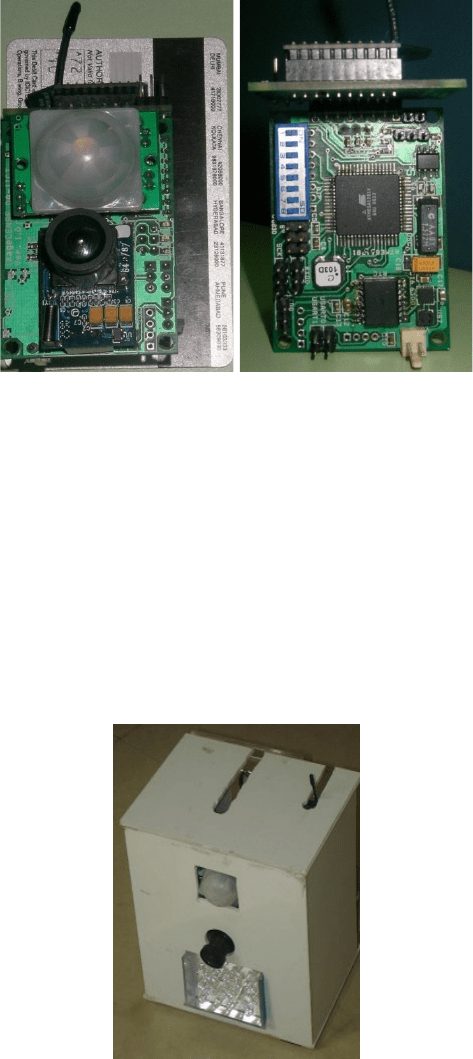
TigerCENSE: Wireless Image Sensor Network 21
Fig. 2. tigerCENSE node, Front and Rear view
without any in between fan out lines, to reduce noise [22]. The whole PCB has
copper pouring to keep the noise at a minimum level as also to dissipate any
heat generated by the node. Figure 2 depicts the PCB made for the node. The
size of the populated PCB is 3.8 x 5.6 x 3.1cm
3
, weighing only 43 gms excluding
power supply and enclosure.
5 Experimental Results
Based on the expected speed of movement and width of walkways(assumed 10
feet) and distance of node from walkway to be 10 feet, a delay of 1.8 sec is kept
Fig. 3. Prototype box used for testing

22 R. Bagree et al.
Fig. 4. Photograph clicked using IR Flash in dark night
between the PIR interrupt and capturing a photograph of the object. Minimum
delay achievable seems to be 250 ms. It is extremely small time as compared
to the response time of traditional traps which ranges into few seconds. Also,
minimum delay between two continuous shots has been found out to be 1s. It is
dictated by the time to transfer the data from Image Sensor to Micro-SD card
and can be reduced by buffering it in a fast memory, if one needs to collect a
burst of images.
To find out the minimum suitable ON time for the IR flash to capture the
stripes clearly on its body, we deployed a prototype box, as shown in Figure 3,
near the cage of a tiger in Kankaria Zoo, Ahmedabad, Gujarat. We programmed
the node to take pictures with increasing ON time starting from 10ms to 70ms
with an increment of 10ms. Figure 4 shows some of the photographs taken by
the node in the dark using an IR Flash. From the experiments we concluded
that an ON time of 30ms is sufficient to get a reasonable quality image with
clear stripes. We need flash time to be as low as possible to reduce blur due to
motion. Some commercial digital cameras use 125 ms flash time, which leads to
significant blare to the extent of image being useless.
6Conclusion
This paper presents an operational prototype for wildlife monitoring using WiSN.
tigerCENSE is compact, non-intrusive, energy efficient and reliable sensing de-
vice. It not only has all the capabilities of traditional traps but has also addressed
most of the drawbacks of them. Integrated development has led to minimum de-
lay of 250 ms. The software protocols and the hardware implementation have

TigerCENSE: Wireless Image Sensor Network 23
all been carefully crafted to optimize the systems energy requirement. Further,
utilizing the solar recharging mechanism, node lifetime would be enhanced.
In future, we can also add some micro-climatic sensors in order to collect
ambiance information. Also, to reduce the amount of wireless data transfer, we
can deploy in-situ digital signal processing technique. This will help us save both
power and time which is highly crucial for the success of the system.
tigerCENSE has been mainly developed to help in the research and conserving
tigers. Besides the use for conducting a census, camera traps can be very useful
for many management tasks. It can be used for human surveillance as well. In
the past, traps have photographed poaching parties. Although due to latency in
collecting the photograph target animal prey were not saved but it eventually
led to the arrest and conviction of known offenders.
Acknowledgment
We would like to thank Bharat Jethwa of GEER foundation (Gandhinagar) for
always being available when needed. Discussion with WII researchers P R Sinha
(Director), S P Goyal, K Sankar, B Pandav, Q Qureshi and others have been
very helpful. We would also like to thank R K Sahu(Superintendent) and others
of Kankaria Zoo, Ahmedabad for giving us permission to carry out trials as
well as helping in the process. We would also like to acknowledge tremendous
contribution made by earlier team members of tigerCENSE, especially Amrit
Panda, Rigveda Kadam, Dheeraj Kota and Hemant Kavadiya.
References
1. Yasuda, M., Kawakami, K.: New method of monitoring remote wildlife via the
Internet. Ecological Research 17, 119–124 (2002)
2. Nath, L.: Camera Trap in Conservation, http://www.nfwf.org/AM/Template.cfm?
Section=Home&TEMPLATE=/CM/ContentDisplay.cfm&CONTENTID=8749
3. http://www.panda.org/what_we_do/endangered_species/tigers/
4. http://www.iucnredlist.org/details/15955/0
5. Staving Off Extinction: A Decade of Investments to Save the World’s Last Wild
Tigers (1995-2004),
http://www.nfwf.org/Content/ContentFolders/NationalFishandWildlife
Foundation/ConservationLibrary/ProgramEvaluations/Staving off
Extinction.pdf
6. McDougal, C.: The Face of the Tiger. Rivington Books, London (1977)
7. http://www.panda.org/what_we_do/endangered_species/tigers/tiger_
solutions/
8. PIR Parallax 555-18017 Datasheet, http://www.parallax.com/detail.asp?
product_id=555-28027
9. Texas Instrument TPS2092 Datasheet, http://www.ti.com/lit/gpn/tps2092
10. COMedia Ltd’s C328RS User-Manual, http://www.electronics123.net/amazon/
datasheet/C328R_UM.pdf
11. Lens of camera, http://www.electronics123.net/amazon/datasheet/C328R.pdf
24 R. Bagree et al.
12. DS3231 RTC Datasheet, http://www.maxim-ic.com/quick_view2.cfm/qv_pk/
4627
13. XBee-PRO OEM RF Modules Product manual, http://www.maxstream.net/
products/XBee/product-manual_XBee_OEM_RFModules.pdf
14. micro-SD Card Datasheet, http://www.sparkfun.com/datasheets/Prototyping/
microSD_Spec.pdf
15. Atmel ATMega1281 Datasheet, http://www.atmel.com/dyn/resources/prod_
documents/doc2549.pdf
16. Polymer Lithium Ion Batteries 6Ah Datasheet, http://www.sparkfun.com/
datasheets/Batteries/UnionBattery-2000mAh.pdf
17. Texas Instruments TPS63001 Datasheet, http://www.ti.com/lit/gpn/tps63001
18. Suntan Super-capacitor TS12S-R Datasheet, http://www.sparkfun.com/
datasheets/Components/TS12S-R.pdf
19. ST microelectronics Power MOSFET STB100NF03L Datasheet, http://www.st.
com/stonline/products/literature/ds/9307.pdf
20. Vishay Semiconductor IR LEDs TSHG5210 Datasheet, http://www.vishay.com/
docs/81810/tshg5210.pdf
21. Jain, V.R., Bagree, R., Kumar, A., Ranjan, P.: wildCENSE: GPS base Animal
Tracking System. In: International Conference on Intelligent Sensors, Sensor Net-
works and Information Processing, Sydney, December 15-16 (2008)
22. Innovative Techniques for Extremely Low Power Consumption with 8-bit Micro-
controllers,
http://www.atmel.com/dyn/resources/prod_documents/doc7903.pdf
Motes in the Jungle: Lessons Learned from a Short-Term
WSN Deployment in the Ecuador Cloud Forest
Matteo Ceriotti
1
, Matteo Chini
2
, Amy L. Murphy
1
,
Gian Pietro Picco
2
, Francesca Cagnacci
3
, and Bryony Tolhurst
4
1
Fondazione Bruno Kessler—IRST, Trento, Italy
{ceriotti,murphy}@fbk.eu
2
Dip. di Ingegneria e Scienza dell’Informazione (DISI), Univ. of Trento, Italy
matteo.chini@gmail.com, gianpietro.picco@unitn.it
3
Edmund Mach Foundation—IASMA, S. Michele all’Adige, Italy
francesca.cagnacci@iasma.it
4
Biology Division, School of Pharmacy and Biomolecular Sciences, Univ. of Brighton, UK
bryonytolhurst@live.co.uk
Abstract. We study the characteristics of the communication links of a wireless
sensor network in a tropical cloud forest in Ecuador, in the context of a wildlife
monitoring application. Thick vegetation and high humidity are in principle a
challenge for the IEEE 802.15.4 radio we employed. We performed experiments
with stationary-only nodes as well as in combination with mobile ones. Due to
logistics, all the experiments were performed in isolation by the biologists on
our team. In addition to discussing the characteristics of links in this previously
unstudied environment, we also discuss the lessons we learned from operating
under peculiar constraints in a peculiar deployment scenario.
1 Introduction
Wireless sensor networks (WSNs) are applied in many scenarios, each with unique
characteristics in terms of connectivity. Assessing the specifics of a target environment
is usually complex, and often entails a preliminary pilot deployment.
Application context and motivation. In this paper we report about such a pilot deploy-
ment, which took place in the cloud forest of the North-Western slopes of Ecuadorian
Andes during March 29–April 3, 2010, and whose details are provided in Section 2.
The work described here is part of a larger research effort targeting the monitoring of
biodiversity in community-based primary cloud forest reserves in this Andean region.
Indeed, this area is at the confluence of two of the world’s hottest biological hotspots:
the Choc´o-Dari´en Western Ecuadorian and the Tropical Andes. Available checklists of
vertebrates likely miss most reptile and mammal species, including medium-to-large
ones. The knowledge about these species’ use of space and community interactions is
essential to ascertain their susceptibility to environmental changes and guide conser-
vation measures. Available information is extremely sparse and based on discontinu-
ous observations and occasional surveys. Direct observation of animals is not a robust
method, due to the very dense vegetation, while traditional indirect methods, such as
capture-mark-recapture or radio-tracking are extremely effort-demanding as these areas
are secluded. Recent advancements in wildlife studies, e.g., the use of GPS devices, are
expensive and therefore applicable to a small number of species and sample size. WSNs
P.J. Marron et al. (Eds.): REALWSN 2010, LNCS 6511, pp. 25–36, 2010.
© Springer-Verlag Berlin Heidelberg 2010
26 M. Ceriotti et al.
provide a new, exciting option in such challenging environmental conditions, especially
for long-term monitoring. Advantages include the need for only a single capture (to fit
the node) and the possibility to study a large sample thanks to the relatively low equip-
ment and deployment cost. However, an essential step in seizing this opportunity is the
evaluation of the node performance in the target environment.
The envisioned WSN application will encompass nodes permanently deployed in
the environment at known locations as well as attached with collars to the animals
themselves. We intend to use motes functionally equivalent to Moteiv’s TMote Sky [3],
arguably the most popular platform today. However, the 2.4 GHz band used by the
CC2420 radio chip on these motes is known to be highly sensitive to foliage and
water—essential ingredients of a cloud forest. Therefore, the primary motivation be-
hind the study described here was to assess the connectivity characteristics of the target
environment to determine the feasibility of our WSN architecture and guide its design.
Related work. A few real-world deployments focus on forests [5], but with character-
istics different from ours. Despite the importance of understanding the connectivity of
the environment targeted by a WSN, this information is rarely reported in the litera-
ture. Instead, the problem is usually tackled with studies targeting either static [4] or
mobile [1] scenarios. All the reported works, however, leverage the possibility to pro-
gressively refine the investigation based on the findings. Our need to define a priori the
entire experimentation pushed us towards a more general methodology, something still
not available in the literature. To design our study we leveraged our prior expertise in
comparing the network characteristics of a tunnel against the vineyard environment [2].
However, the differences in the application scenario, involving mobile nodes, and the
inability to access the experiment site demanded a significant revision of our techniques.
Challenges. The deployment itself presented non-trivial logistical difficulties due to
the geographical distance and the harshness of our target environment. Things were
further complicated by the fact that the WSN experiments were “piggybacked” on the
biologist’s trip to Ecuador for other research purposes.
As a consequence, we faced rather unusual requirements. In the literature, similar
experiments are typically run by the WSN developers, often in rather controlled en-
vironments. Instead, in our case the experiments had to be run by the biologists, and
in isolation. Remote WSN configuration was not an option, due to the absence of data
connectivity from the experiment location—the jungle. Similarly, a multi-phase deploy-
ment, where the output of one experiment guides the setup of the next, was also not an
option due to the distance between the experiment location and the closest Internet ac-
cess, and to the duration of the experiments. The latter was limited by the biologist’s
already-established trip schedule, further reduced by the inevitable lost baggage.
Simply put, this meant that our hw/sw WSN setup had to work out of the box for
the entire duration of the experimental campaign, and had to be simple enough to be
operated by someone without expertise with this technology.
Contributions and findings. The details about our cloud forest experiments are pro-
vided in Section 3. The main contributions of this paper are the following:
1. Low-power wireless in the jungle environment. In Section 4 we analyze the gath-
ered data. The depth of the analysis is somewhat limited by the aforementioned
logistic problems, as we did not have a second chance to investigate the source
of unexpected behaviors. However, we are not aware of other studies investigating
Motes in the Jungle 27
low-power wireless communication in an environmentsimilar to ours and therefore,
even with these limitations, we believe our study can be of value for the research
community. Moreover, some of our findings are somewhat surprising. For instance,
we expected links to be rather short and unreliable, due to foliage, water, and hu-
midity. Instead, our data show that 30-meter links are common, and in some cases
reliable communication occurs up to 40 m.
2. Mobile nodes as a connectivity exploration tool. The inclusion of experiments with
mobile nodes was initially motivated by the animal-borne nodes in our envisioned
application. We expected to draw the bulk of our considerations from stationary-
only experiments. Instead, mobile nodes played a much more relevant role in our
study. On one hand, the stationary-only experiments did not deliver the amount
of data we expected. The connectivity patterns were not known in advance, and a
multi-phase deployment was not an option, as already discussed. Mobile experi-
ments provided a data set complementing the stationary ones. On the other hand,
with hindsight, the use of mobile nodes is an effective way to explore connectiv-
ity, regardless of mobility requirements. Intuitively, a broadcasting node moving
through a single, well-designed path yields a wealth of information, more varied
and fine-grained w.r.t. stationary-only experiments, even considering the interfer-
ence introduced by the person executing the experiments. This enables a more
precise “connectivity map” of the environment, that can be used for instance to
guide node placement. We believe the use of mobile nodes can become an essential
element of studies aimed at characterizing connectivity in WSN environments.
3. When WSN developers are not in charge. Our experiments were run by someone
other than the WSN developers because of opportunity. There may be other reasons,
e.g., the necessity to require authorizations or safety concerns related to the target
deployment area. In any case, for WSN to become truly pervasive, end-users must
be empowered with the ability to deploy their own system. The lessons we learned,
distilled in Section 5, can be regarded as a contribution towards this goal.
2 Deployment Scenario
Location. The community-based reserve of Junin, in the Intag region of the Imbabura
province in Ecuador (0
o
16’19.09”N; 78
o
39’28.92”W) is between 1,200 and 2,800 m
above sea level of the North-Western slopes of the Ecuadorian Andes. Significant
portions of these mountain areas are primary cloud tropical forests, almost permanently
cloudy and foggy. According to the United Nation’s World Conservation Center, cloud
forests comprise only 2.5% of the world’s tropical forests, and approximately 25% are
found in the Andean region. Therefore, they are considered at the top of the list of threat-
ened ecosystems. The climate is tropical, and the flora and fauna incredibly rich, with
about 400 species of birds and 50 known mammal species (including 20 carnivores),
many probably still unchecked or even unknown. The small human community of about
50 people is 20 km from the closest village, and a 7 hour dirt-road drive from the closest
town.The vegetation is made by relatively scatteredmature trees, constituting the canopy,
and a dense undergrowth of shrubs and epiphites. During the rainy season (November-
May), when we ran our experiments, it rains every day for nearly the entire day.
WSN Equipment. Our experiments used 18 TMote Sky nodes, equipped with the Chip-
Con 2420 IEEE 802.15.4-compliant,2.4 GHz radio and on-board inverted-F micro-strip