Lowenthal G., Airey P. Practical Applications of Radioactivity and Nuclear Radiations
Подождите немного. Документ загружается.

9.3 Environmental applications of radioisotopes 291
(d)
(e)
Figure 9.5. (cont.)
involves balancing dredging costs with estimates of the ef®ciency with which
dumped material re-enters the shipping channel. Tracer techniques have been used
to study the rate of movement of dredge spoil at proposed dump sites.
. Sustainable development in the coastal zone: prediction of the impact of a proposed
development on the sand budgets requires good baseline information on bed load
transport.
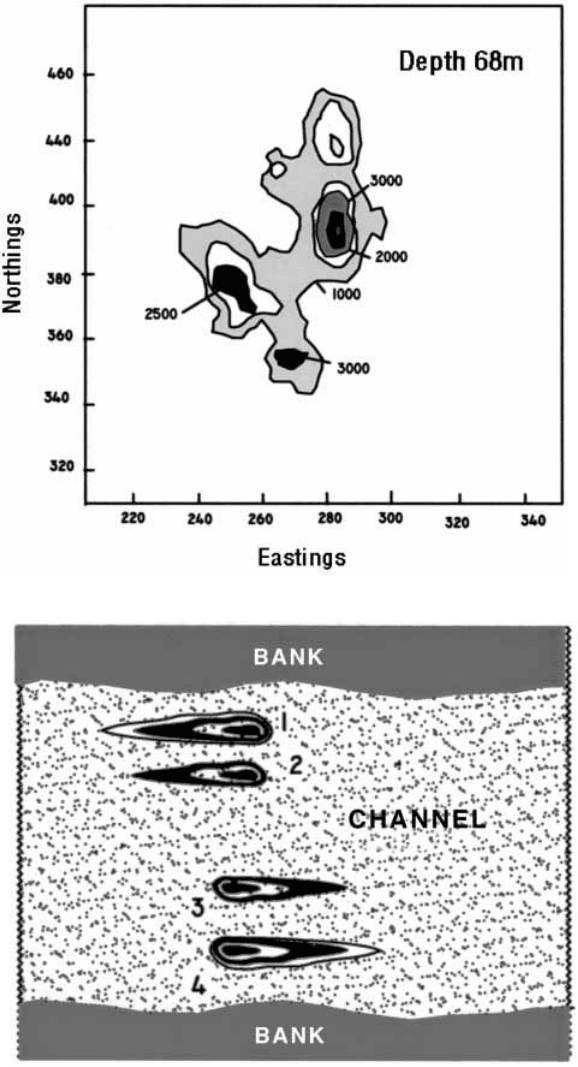
The results of a typical bed load study are sketched in Figure 9.5(d).
Information was required on the dynamics of sand transport in a channel
connecting a coastal lake system to the sea. Radiotracer was injected at four
locations across the channel. In the northern part of the channel, the net
migration was in one direction; in the southern section, in the opposite
direction. The observed sand migration was the consequence of the current
patterns in the channel during ebb and ¯ood tides. It would have been
dif®cult to obtain such direct information using other methods.
A number of case studies in Latin America and Europe have been reviewed
by Aun and Bandiera in IAEA (1995). On the basis of long experience, the
authors concluded that the bene®ts of tracer technology will only be fully
realised as part of a multi-disciplinary approach to coastal engineering
problems.
Detector calibration
Success in obtaining reliable quantitative information on sand and sediment
movement depends on the quality of the calibration of the monitoring
detector. As with the total count method for measuring ¯ow rates in rivers
and pipelines (Sections 9.3.2 and 8.3.6), the major dif®culty is reproducing, in
the laboratory, the source±detector geometry that occurs in the ®eld.
Calibration of the detector ef®ciency is made in a large water tank partially
Radionuclides to protect the environment292
(f )
Figure 9.5. (cont.)
®lled with sand and designed to simulate conditions at the bottom of the lake
or estuary. A realistic geometry can often be simulated by mounting the
detector on a rig a few centimetres above the surface of the sand (Figure
9.2(b)).
Complications can arise in the ®eld because the radioactive sand released
to the surface is incorporated into the mobile layer as a consequence of
periodic re-suspension and deposition processes associated with bed load
transport. Over extended periods, bioturbation might also be signi®cant. As a
consequence of g ray attenuation, the ef®ciency with which the detector
responds to radioactive sand particles depends on its depth. This effect may
be simulated in the calibration tank by covering the radionuclide source with
successive layers of sediment and taking repeated measurements. When
calculating the calibration factor an assumption has to be made concerning
the distribution of the tracer as a function of depth. The validity of the
assumption should be checked if possible by collecting cores at a number of
locations within the radioactive patch, sectioning the cores and measuring the
activity pro®les directly (Figure 9.5(c)).
Suspended sediment gauges
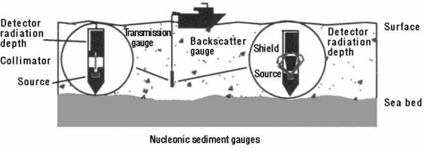
Nucleonic gauges have been developed for the accurate measurements in real
time of the levels of suspended sediments in rivers and estuaries (Figure
9.5(f )). These data are of interest in understanding issues as diverse as the
stability of dredge spoil grounds and, more generally, the impact on estuaries
of sediments transported to the coastal zone by river systems. Suspended
sediment gauges are designed as gamma ray transmission (Section 7.2.1) or
gamma ray backscatter (Section 7.2.2) gauges. Both types of gauges can
measure sediment loadings equivalent to bulk density changes of less than
1%. With transmission gauges, the sensitive region is the small volume
between the source and the detector. This is a disadvantage compared with
the backscatter gauge, which has a much larger sensitive volume. On the
other hand, the response of the transmission gauge is much less sensitive to
effects due to the proximity to boundaries such as the bed of the estuary or
the water surface. Applications have been made to:
. continuous monitoring of high (say 1 to 100 kg/m
3
) sedim ent loadings in rivers as a
function of rainfall and at different depths;
. surveying the levels of suspended sediments in reservoirs and harbours as a
function of location and depth; and
. optimising the ef®ciency suction dredging by monitoring the concentration of
dredge spoil in the well of the dredge as a function time.
9.3 Environmental applications of radioisotopes 293
Further information may be obtained from Tazioli and Caillot (IAEA, 1983)
and Aun and Bandeira (IAEA, 1995).
9.4 Applications of naturally occurring radioisotopes
9.4.1 Man-made versus environmental radioisotopes
Naturally occurring, or environmental radioisotopes were introduced in
Section 9.2.2 when they were classi®ed into three categories: cosmogenic
isotopes, fall-out products and primordial isotopes (Table 9.2). Applications
of man-made and environmental isotopes are generally complementary.
Man-made radionuclides are selected from a large number of available
isotopes, are used to label a particular component of a complex system and
are injected at a precise location and according to a precise protocol.
Consequently, very detailed information is obtained on the behaviour of an
environmental system in the vicinity of the injection.
By contrast, environmental isotopes are widely distributed by natural
processes and are used to obtain information over a regional scale. By and
large the data re¯ect the cumulative effect of the environmental process (say,
erosion, siltation, groundwater movement) over time scales related to the half
life of the isotope. Information is normally obtainable over periods equivalent
to four or ®ve half lives. For instance
210
Pb (T
1/2
= 22.3 y) is used to assess
siltation rates over about 100 years, whereas,
14
C(T
1/2
= 5730 y) and
230
Th
(T
1/2
= 75 400 y) provide information over about 20 000 and 200 000 years
respectively.
9.4.2 Erosion studies
A new use for caesium-137
Good husbandry of fertile soil is central to sustainable development in a
world where populations are expanding. Every effort is being made to
minimise losses due to water and wind induced erosion. Part of this effort
involves the development of reliable measurement techniques. A great deal is
being achieved with satellite imaging. However, there is a need to validate or
interpret the imaging data with independent estimates of erosion patterns at a
catchment scale. One such method involves the use of the environmental
isotope
137
Cs to estimate erosion rates over a whole catchment area.
137
Cs is a
®ssion product which was injected into the upper troposphere and lower
stratosphere during atmospheric nuclear tests. These radionuclides were
Radionuclides to protect the environment294
distributed world-wide by the global atmospheric circulation and, with the
passage of time, diffused to the surface of the earth. There the
137
Cs adsorbed
strongly onto the clay fraction of the soils, and acted as a natural radiotracer
for subsequent erosion and accumulation processes.
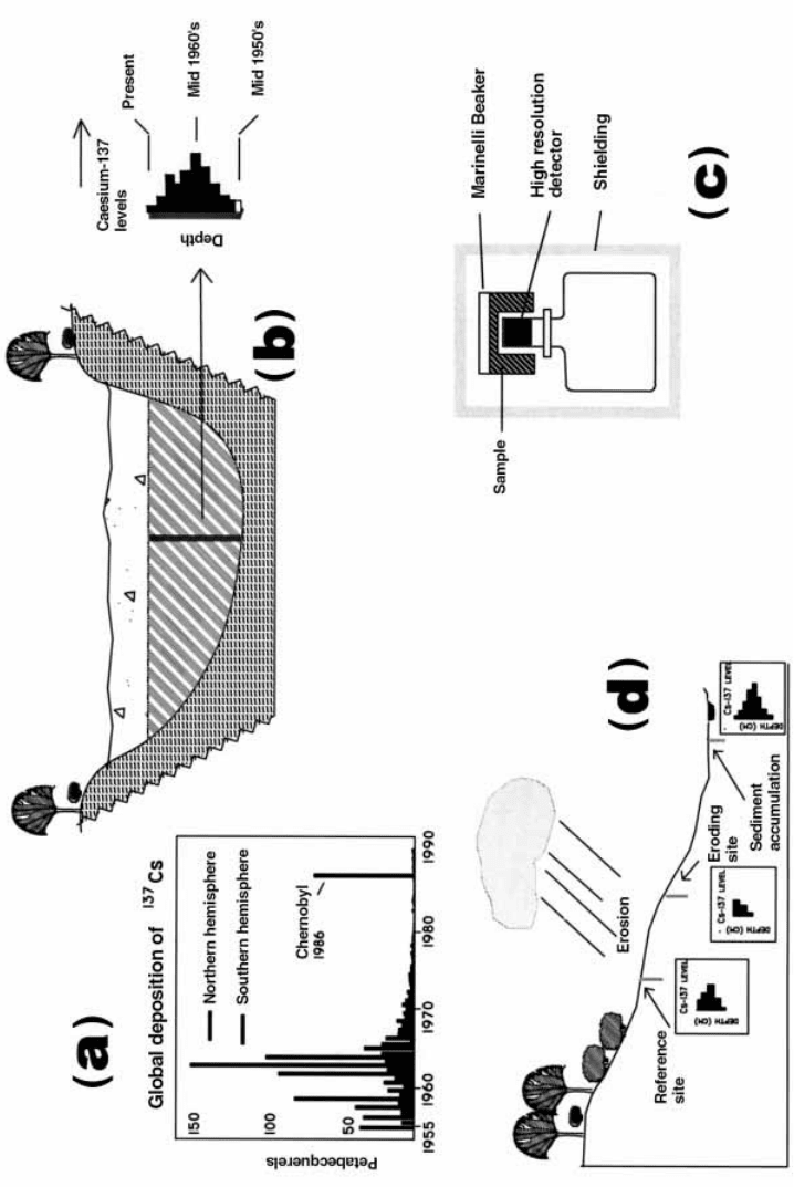
Measurable levels of
137
Cs started to appear in soil during the mid-1950s,
reached a peak in the mid-1960s and then declined following the signing of the
Atmospheric Test Ban Treaty in 1964 (Playford et al., 1992). The year by year
variation of the levels of
137
Cs reaching the earth is similar to that of other
`fall-out' products such as tritium and carbon-14 (Figure 9.6(a)) and is known
as the input function. Caesium-137 has a suf®ciently long half life (30.1 y) to
remain useful for the present purpose for many more years to come.
Environmental
137
Cs was ®rst used as a natural tracer to measure the rate
of sedimentation in lakes and reservoirs (Pennington, 1972, Pennington et al.,
1973). The sediment with the
137
Cs attached accumulates in the lake as a
consequence of erosion in the surrounding catchment areas (Figure 9.6(b)). If
there is normal sheet erosion over the catchment, the shape of
137
Cs input
function is preserved in the sediments. It is the shape of the pro®le and not
the radionuclide decay which serves as the basis for dating the accumulation
of the sediments. The ®rst appearance of environmental
137
Cs in the mid-
1950s and the peak in the mid-1960s are both readily identi®able features.
These data may be compared with results from other dating methods and
with the known historical record to gain an improved understanding of
changes in erosion patterns.
Experimentally, the
137
Cs pro®le is measured by
. collecting and sectioning a core obtained from the soil in the region of interest;
. placing each dried and weighed section of the core in a Marinelli beaker over a
high-resolution detector (Figure 9.6(c));
. measuring the countrate in the 662 keV g ray peak; and
. calculating the speci®c activity of the
137
Cs by comparison with results obtained
from a calibrated standard.
Procedures and applications
The measurement, and in particular the prediction, of the rate of erosion of
fertile soils is a key to the development of strategies for the long-term
sustainability of agriculture. The rate of surface erosion depends on a number
of parameters such as the distribution, the amount and the intensity of
rainfall, the slope of the land, the nature and extent of vegetation and the
erodability of the soil. Attempts have been made to develop equations linking
erosion rates to these parameters, and to use the equations to predict erosion
over a wide geographic region (Ritchie and Ritchie in IAEA, 1995). One of
9.4 Applications of naturally occurring radioisotopes 295
the most widely used is the Universal Soil Loss Equation (USLE). However,
it has often been inappropriately applied, both in the United States where it
was developed and around the world (Wischmeier, 1976). An independent
method for the validation of such equations is required.
Carefully planned and executed measurements of the
137
Cs pro®les on the
catchment slopes provide a basis for independent estimates of erosion rates.
The principle is shown schematically in Figure 9.6(d). The greater the erosion
rate, the greater the removal rate of soil and the less the residual
137
Cs in the
soil pro®le. On the other hand, the greater the rate of accumulation of soil in
a catchment, the greater the level of
137
Cs in its pro®le. Activity pro®les
similar to those sketched in the ®gure are not dif®cult to observe. A key for
the reliable interpretation of the resulting data is the identi®cation of a
reference location on the slope where there has been minimal erosion or
sedimentation over the past decades. The identi®cation of the reference site
usually relies on the judgement of local experts.
A complicating factor is that the countrate in the 662 keV peak attributable
to
137
Cs is often little above background. Experimentally, the background
may be reduced by using a shielded gamma spectrometer with a Compton
suppression capability. Such equipment is, however, specialised and expen-
sive. Mathematical procedures for calculating the speci®c activities of gamma
emitting isotopes at very low levels in natural samples are available, but their
discussion is beyond the scope of this text (Gilmore and Hemmingway, 1995).
An interesting result
The application of
137
Cs to the study of erosion has proven useful to studies
not only on a regional scale but also at the level of an individual farm and in
forested areas. Measurements can contribute to studies of the impact of land
use management on erosion. For instance, a study on a vineyard revealed
that for each bottle of wine produced, approximately one bottle of fertile soil
was lost to the cultivated area. If sustainable development is to be achieved,
an understanding is needed of the total environmental cost of production.
Other techniques
The procedure for using
137
Cs as a dating technique is different from that
used for the majority of radiometric methods. It does not depend on the
9.4 Applications of naturally occurring radioisotopes 297
3 Figure 9.6. Application of environmental
137
Cs to erosion measurements. (a)
The global distribution of
137
Cs (Playford et al., 1992). (b) The dating of sedimen t
accumulation in lakes and reservoirs from
137
Cs levels in drill core. (c) Counting of
sediment samples in a Marinelli beaker; (d) Application of
137
Cs measurements to
catchment erosion.
measurement of radioactive decay but on identifying special features of the
input function such as the onset of the
137
Cs activity (mid-1950s) and the
activity maximum (mid-1960s).
There are also the conventional methods of radiodating using
210
Pb
(T
1/2
= 22.2 y),
14
C(T
1/2
= 5730 y) or
230
Th/
234
U (Figure 1.5), which can serve
to measure sediment accumulation over time scales up to decades, tens of
thousands and hundreds of thousands of years respectively. In these ways,
insights can be obtained on the evolution of estuaries or other geologic
features over recent geological time. Some details are presented in Table 9.2.
9.4.3 Groundwater
Introduction
Adequate resources of fertile soil and clean drinking water are essential for
public health. To complement the discussion of the measurement of erosion
offered in the previous section, attention will now be paid to studies of sub-
surface water. This resource becomes increasingly important in areas where
reserves of good quality surface water have diminished due, for example, to
prolonged dry spells, over-exploitation or contamination. The challenge is to
establish management regimes that will ensure the sustainability of ground-
water yields.
Groundwater resource evaluation
Environmental radioisotopes have proved a useful aid in the investigation of
underground water with a few examples listed in Table 9.1. Applications have
been directed towards:
. identifying the sources of recharge water, i.e. the sources of surface water which
seep unde rground to replenish the basin;
. estimating the extent of mixing of underground water from different sources;
. calculating the age of groundwater samples, i.e. the time which has elapsed since
the water percolated underground;
. deducing the direction and rate of groundwater ¯ow; and
. understanding the processes leading to degradation in groundwater quality.
The environmental isotope approach is here illustrated with reference to a
simpli®ed version of the water table (Figure 9.7). The data obtained for this
purpose are often used to validate groundwater hydraulic models which link
the known water table levels (technically the piezometric surfaces) to the
properties of the water bearing strata (Clark and Fritz, 1997).
Radionuclides to protect the environment298
Two examples will be provided: the location of recharge areas and the
dating of underground water.
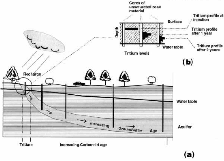
Location of recharge areas
Recharge is the process whereby surface water percolates through the soils
and other overlying strata to replenish the underground water. It is therefore
important to ensure that areas of recharge are clearly identi®ed and well
managed. Environmental tritium can make a signi®cant contribution to this
end. As shown schematically in Figure 9.7(a) the direction of groundwater
¯ow is away from recharge areas. The presence of signi®cant levels of tritium
is indicative of groundwater which has in®ltrated through the unsaturated
zone in post-nuclear times (Table 9.2), that is of samples collected from a
bore in or close to the recharge area. It is recalled that most of the tritium in
the environment was derived from atmospheric nuclear testing.
As an aside, it may be noted that small injections of man-made tritium can
be used to obtain detailed information on the transport of water in the
9.4 Applications of naturally occurring radioisotopes 299
Figure 9.7. Application of environmental isotopes to groundwater studies. (a)
Schematic diagram showing underground water percolating through an aquifer and
sampled at various locations for age dating with, say, carbon-14. (b) The use of man-
made tritium to study the rate of recharge of in®ltrating rainwater to an aquifer.
unsaturated zone. Tritium is injected at a constant depth (say 1 m). Cores
within the unsaturated region are collected at time intervals ranging from
about 1 month up to, say, 3 years. With the passage of time, the tracer
maximum is displaced down the pro®le towards the water table. At the same
time, it exhibits dispersion. This behaviour is shown in Figure 9.7(b).
The dating of underground water
The age of a groundwater sample is the time required for the water to migrate
from the area of recharge to the extraction bore. Groundwater migrates away
from the recharge area at a rate which depends on differences in the water
table levels (the so-called piezometric gradient) and the properties of the
water bearing strata. Groundwater ages can either be computed from
hydraulic data, or measured using isotope techniques.
As indicated above, environmental tritium is used to identify water which
has recharged in post-nuclear times. However, modern techniques can be
used to measure tritium to such low levels that groundwater dating up to 100
years is possible. Carbon-14 (T
1/2
= 5730 y) is widely used for the dating of
groundwater samples with residence times ranging from a few hundred up to
30 000 years.
Unlike tritium (
3
H), carbon is not a component of water but a solute. The
calculation of the groundwater age from the measured activities involves not
only an assessment of the carbon-14 levels at recharge, but also an under-
standing of the source and subsequent behaviour of the dissolved carbonate
in the groundwater system. By dating a large number of samples across a
basin, contours of equal age (isochrones) can be drawn from which the
groundwater ¯ow lines can be deduced.
Chlorine-36 (T
1/2
= 302 000 y) may be used to date water with residence
times in excess of one million years. For instance, the Great Artesian Basin,
Australia, covers about a third of the continent. The major recharge area is in
the east, and the water ¯ows in a generally westerly and southwesterly
direction. The size of the basin is such that groundwater ages reach two
million years near some of the discharge areas. In order to validate chlorine-
36 as a groundwater dating method, an inter-comparison was made between
the isotopic ages, and those calculated from a hydraulic model. Satisfactory
agreement was found.
The atom ratio
36
Cl/Cl depends not only on the age and the hydraulic
properties of the groundwater, but also on the extent to which it has dissolved
sub-surface chloride. Chlorine-36 techniques are being widely used to study
salination and the degradation of groundwater quality.
Radionuclides to protect the environment300